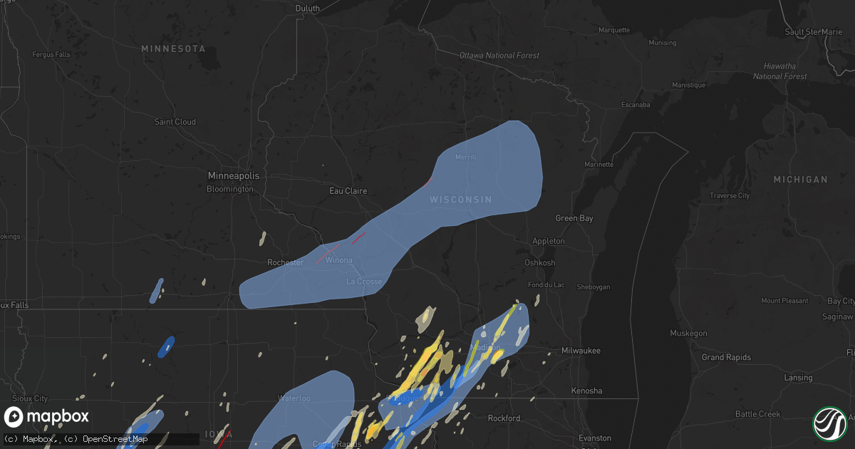
Hail Map in Wisconsin on May 21, 2024
Get this storm
May 21 map
$229
one time, instant access
Download today. No call, no setup
Keep the $229
Bought the map and want the full workflow? Apply the entire $229 to a subscription within 7 days. None of it is wasted.
Every map, not just this one
This buys you this map. Subscription and you get every map we run, in the markets you choose from a few cities to whole states to nationwide. Plus real-time alerts the moment a storm fires.
Contact data
Name, contact info, occupancy, even credit band for addresses in the footprint. You go from where it hit to who to call.
Become the source they trust
Unlimited branding weather history reports on demand. You already have the documented answer ready for the property owner, and you are the one who showed up with it.
Property data and RoofTrace estimates
Pull up any address you have got, its value and the exact code rules for that jurisdiction, straight from One Click Code. Then RoofTrace estimates the squares, pitch, and roof value, priced the way you price.
Storm reports in Wisconsin
Wisconsin
| Date | Description |
|---|---|
| 05/21/20246:56 PM CDT | Branches and tree damage. Time estimated. |
| 05/21/20246:56 PM CDT | Preliminary information: storm survey results identified an ef1 tornado that touched down near augusta... And moved north. The path length was about 10 miles... Maximum |
| 05/21/20246:56 PM CDT | Emergency management reported powerlines and trees down in augusta. Time estimated via radar. |
| 05/21/20246:55 PM CDT | Trained spotter reports quarter to ping pong sized hail. |
| 05/21/20246:54 PM CDT | A local report indicates 75 MPH wind near 1 N Hazel Green |
| 05/21/20246:51 PM CDT | Report from mping: 1-inch tree limbs broken; shingles blown off. |
| 05/21/20246:51 PM CDT | Few large branches and trees down in spring green. Report relayed via social media. Time estimated based on radar. |
| 05/21/20246:51 PM CDT | Shed roof blown off outside of dodgeville. Time estimated based on radar. Report relayed via broadcast media. |
| 05/21/20246:49 PM CDT | One small tree snapped. |
| 05/21/20246:47 PM CDT | Tree damage near highway 16. |
| 05/21/20246:47 PM CDT | 55 kts. |
| 05/21/20246:45 PM CDT | Several branches down... Damaging some cars. |
| 05/21/20246:45 PM CDT | Amateur radio reporting downed tree branches measuring 7 inches in diameter. Time estimated via radar. |
| 05/21/20246:44 PM CDT | Power lines down highways 56 and 35. |
| 05/21/20246:42 PM CDT | Large tree down over road in northside of la crosse. |
| 05/21/20246:42 PM CDT | A local report indicates 59 MPH wind near 1 NNW Onalaska |
| 05/21/20246:42 PM CDT | Barn destroyed. |
| 05/21/20246:42 PM CDT | Tree down on wells street. |
| 05/21/20246:41 PM CDT | A few 3 to 4 inch diameter branches down. |
| 05/21/20246:40 PM CDT | Tree toppled on house. |
| 05/21/20246:36 PM CDT | Report from mping: quarter |
| 05/21/20246:35 PM CDT | 2 to 3 inch branches down along 150ft line of trees. |
| 05/21/20246:30 PM CDT | Large tree snapped blocking most of south street. |
| 05/21/20246:21 PM CDT | Estimated size from pic. |
| 05/21/20246:21 PM CDT | Barns and trees blown down. |
| 05/21/20246:18 PM CDT | A local report indicates 1.00 inch wind near 1 NW Platteville |
| 05/21/20246:15 PM CDT | Main barn and heifer barn of a farmstead destroyed. Trees snapped. Possible tornado damage. |
| 05/21/20246:14 PM CDT | A local report indicates 1.50 inch wind near Platteville |
| 05/21/20244:50 PM CDT | A local report indicates 1.00 inch wind near Dodgeville |
| 05/21/20244:00 PM CDT | A local report indicates 1.75 inch wind near Dickeyville |
| 05/21/20243:57 PM CDT | A local report indicates 1.00 inch wind near Dickeyville |
| 05/21/20242:00 PM CDT | A 25 foot tree was uprooted 2 miles north of wausau. Report relayed via wsaw-tv. |
| 05/21/202412:48 PM CDT | Hail at least 1 inch in diameter via social media video. |
| 05/21/202412:43 PM CDT | Size estimated from social media pic. Time estimated from radar. |
| 05/21/202412:05 AM CDT | 18 inch tree snapped. |
| 05/21/202412:00 AM CDT | Delayed report of a large tree down. Time estimated from radar. |
| 05/20/202411:50 PM CDT | Multiple trees down. |
| 05/20/202411:48 PM CDT | Large tree down... Snapped at base. |
| 05/20/202411:44 PM CDT | Relayed through wisn. Large tree snapped at base... But was rotted out in middle. |
| 05/20/202410:35 PM CDT | Trees down with home damage. Multiple additional trees with roads blocked in the area. |
| 05/20/202410:35 PM CDT | Multiple trees and wires down across washington island. Officials are starting to clear roads. |
| 05/20/202410:11 PM CDT | Trees down. |
| 05/20/202410:10 PM CDT | Trees and wires down. |
| 05/20/202410:08 PM CDT | Tree down in sevastopol. |
| 05/20/202410:05 PM CDT | Tree down blocking bay shore drive near horseshoe bay. Time estimated based on radar. |
| 05/20/202410:04 PM CDT | Large tree branches down on a roof. |
| 05/20/20249:58 PM CDT | Tree down blocking road between oregon st. And 7th ave. Time based on radar. |
| 05/20/20249:53 PM CDT | Trained spotter reported 70 mph winds as well as downed trees and lose of power. |
| 05/20/20249:49 PM CDT | A local report indicates 1.00 inch wind near 1 W Fall River |
| 05/20/20249:45 PM CDT | Multiple reports of trees and powerlines down across the city of green bay. |
| 05/20/20249:41 PM CDT | A lot of tree limbs down covering s taylor road in green bay. |
| 05/20/20249:41 PM CDT | Large tree split. |
| 05/20/20249:38 PM CDT | Tree limb damage to a small tree along menomonee falls-brookfield border. |
| 05/20/20249:36 PM CDT | Time estimated by radar. |
| 05/20/20249:28 PM CDT | Tree limb fell onto fence. |
| 05/20/20249:25 PM CDT | Many tree limbs down in wales on multiple properties. |
| 05/20/20249:25 PM CDT | Large branches down and power out. |
| 05/20/20249:24 PM CDT | Delayed report. |
| 05/20/20249:20 PM CDT | Multiple reports of wires down. Report of tree through roof. |
| 05/20/20249:14 PM CDT | Large tree snapped at base but rotted a bit.. |
| 05/20/20249:07 PM CDT | Fascia ripped off a house in elkhorn. Time estimated by radar. |
| 05/20/20249:06 PM CDT | Trained spotter reported trees down on old highway 18 east of sevens point. Road is impassable. |
| 05/20/20249:05 PM CDT | Reports of trees and power lines down ac |
| 05/20/20249:05 PM CDT | Reports of trees and power lines down across dane county. |
| 05/20/20249:02 PM CDT | Trees and wires down in kaukauna and little chute. Semi tipped over in kaukauna. Time based on radar. |
| 05/20/20249:01 PM CDT | Large tree uprooted and laid out across the road. |
| 05/20/20248:59 PM CDT | A local report indicates 62 MPH wind near Fox Lake |
| 05/20/20248:57 PM CDT | Numerous reports of downed trees and power lines across the janesville area. With a few reports of trees falling on vehicles. Time estimated based on radar. |
| 05/20/20248:57 PM CDT | Trained spotter reported estimated wind gusts of 70 mph as well as rainfall rates of over 1 inch per hour and frequent cloud to ground lightning. |
| 05/20/20248:57 PM CDT | Ef-1 tornado confirmed in the village of kaukauna. 95 mph max wind speeds. 5/21/24 857 pm to 901 pm. Separate damage surveys conducted by nws employees on 5/21/24 and 5 |
| 05/20/20248:55 PM CDT | Multiple reports of trees down on roads across the northern half of dodge county. |
| 05/20/20248:54 PM CDT | Trees uprooted in columbus... Wi. Reported via columbia county ares weather net. |
| 05/20/20248:50 PM CDT | Heavy downfall... Severe bending of trees... Winds of 60+ |
| 05/20/20248:50 PM CDT | Spotter reported several trees down in the city of kaukauna with lose of power. Spotter estimated wind gusts reached 70 mph as storms moved through. |
| 05/20/20248:48 PM CDT | Trees down at the intersection of highways 8 and 45 in the town of monico. Time estimated from radar. |
| 05/20/20248:40 PM CDT | Numerous branches down. |
| 05/20/20248:38 PM CDT | Tree damage reported in cottage grove. Time estimated by radar. |
| 05/20/20248:35 PM CDT | Kmsn airport. |
| 05/20/20248:34 PM CDT | Report of high winds leading to broken tree limbs in the mcfarland area. Time estimated by radar. |
| 05/20/20248:30 PM CDT | A local report indicates 59 MPH wind near 2 WNW Middleton |
| 05/20/20248:30 PM CDT | Multiple trees and limbs down. |
| 05/20/20248:30 PM CDT | Trees down in township of vilas. |
| 05/20/20248:30 PM CDT | Trees and wires down near harrison. Time based on radar. |
| 05/20/20248:29 PM CDT | Large tree... One to one and a half feet in diameter... Snapped clean approximately 4 to 5 feet above the ground. |
| 05/20/20248:28 PM CDT | Tree damage reported in albany. Time estimated by radar. |
| 05/20/20248:25 PM CDT | We had several trees go down at around 8:25 tonight including a large old oak tree across west old sauk road and a pine snapped in half here in middleton township. Many |
| 05/20/20248:25 PM CDT | Numerous black cherry... Hickory and elm trees with split tops and large limbs down. Two main gusts around 825pm and again at 829pm. |
| 05/20/20248:24 PM CDT | Multiple large tree limbs snapped off of a tree and onto the roadway. |
| 05/20/20248:22 PM CDT | Multiple trees and power lines down. A few homes with trees down/against them. |
| 05/20/20248:21 PM CDT | Tree damage... With flying debris reported. Time estimated by radar. |
| 05/20/20248:20 PM CDT | Multiple trees down in monroe. Time estimated by radar. |
| 05/20/20248:18 PM CDT | Tree damage reported across berlin. Time estimated by radar. |
| 05/20/20248:18 PM CDT | Reports of tree damage around fox lake area. |
| 05/20/20248:18 PM CDT | Tree damage reported in belleville. Time estimated by radar. |
| 05/20/20248:16 PM CDT | Corrects time of previous tstm wnd dmg report from 4 ne columbus. Tree snapped in half. |
| 05/20/20248:15 PM CDT | A local report indicates 61 MPH wind near 3 ENE Monroe |
| 05/20/20248:15 PM CDT | Part of an apartment roof missing. Time estimated based on radar. Report relayed broadcast media. |
| 05/20/20248:15 PM CDT | Tree damage reported in new glarus. Time estimated by radar. |
| 05/20/20248:14 PM CDT | Multiple reports of trees and wires down across the merrill area. Time based on radar. |
| 05/20/20248:11 PM CDT | Relayed through wmtv madison. 3 large trees uprooted. |
| 05/20/20248:10 PM CDT | Large tree snapped at base. |
| 05/20/20248:09 PM CDT | Street signs bent over at the intersection of highways 54 and f to west of plover. |
| 05/20/20248:07 PM CDT | A local report indicates 60 MPH wind near Wausau Downtown Airport |
| 05/20/20248:06 PM CDT | Significant damage to a building. |
| 05/20/20248:06 PM CDT | Numerous trees down on the north side of madison along sherman and northport. Warner park. |
| 05/20/20248:05 PM CDT | Trees down in the necedah and armenia area. |
| 05/20/20248:04 PM CDT | Report from mping: 1-inch tree limbs broken; shingles blown off. |
| 05/20/20248:01 PM CDT | Trees down on houses. |
| 05/20/20248:00 PM CDT | Scattered tree limbs down... Some large... From just west of middleton to just east of mazomanie on highway 14. |
| 05/20/20248:00 PM CDT | Trees down. |
| 05/20/20247:59 PM CDT | Large trees uprooted. |
| 05/20/20247:59 PM CDT | Damage is worst from state highway 11 moving northeast from there. |
| 05/20/20247:59 PM CDT | Tree damage reported in darlington. Time estimated by radar. |
| 05/20/20247:58 PM CDT | Lots of tree and power line damage including sheds. |
| 05/20/20247:58 PM CDT | Several trees down including a large old 4 foot diameter oak tree across old sauk road and a 12 inch pine snapped in half. Many large 3 to 6 inch branches down as well. |
| 05/20/20247:57 PM CDT | Reported at kisw - alexander field south wood county airport. |
| 05/20/20247:56 PM CDT | Extensive tree damage on the south side of verona. |
| 05/20/20247:56 PM CDT | Nws storm survey team estimates 90-100mph winds west of gratiot. Barn with roof blown off. |
| 05/20/20247:54 PM CDT | Two large highway distance signs on eastbound 151 west of verona were bent down. |
| 05/20/20247:53 PM CDT | Nws storm survey concludes that straight line wind damage occurred in association with 90 mph winds. This damage occurred in lafayette county from state hwy 11 between |
| 05/20/20247:53 PM CDT | An nws storm survey concludes that 70 mph straight line winds caused damage to a farmstead southeast of gratiot. Damage to trees and farm outbuildings was scattered/lyi |
| 05/20/20247:51 PM CDT | Ef-1 tornado to the northwest of the village of edgar. 90 mph max wind speeds. 5/21/24 751 pm to 754 pm. Damage survey conducted by nws on 5/22/24. Damage to farm build |
| 05/20/20247:50 PM CDT | Tree snapped near base. Time estimated by radar. |
| 05/20/20247:50 PM CDT | Top of tree trunk snapped. |
| 05/20/20247:47 PM CDT | Report from mping: 3-inch tree limbs broken; power poles broken. |
| 05/20/20247:45 PM CDT | Report of multiple limbs and trees down near lodi marsh. Time estimated by radar. |
| 05/20/20247:45 PM CDT | Measured at the marshfield wisconet station. |
| 05/20/20247:45 PM CDT | Report from mping: 3-inch tree limbs broken; power poles broken. |
| 05/20/20247:45 PM CDT | Law enforcement has received public tornado on the ground near unity... Wi. |
| 05/20/20247:45 PM CDT | Law enforcement has received a public report of a tornado on the ground near unity... Wi. |
| 05/20/20247:39 PM CDT | Marshfield area. Trees down at eagle road and county h. |
| 05/20/20247:39 PM CDT | Trees down in marshfield. Wren and robin roads partially blocked. |
| 05/20/20247:37 PM CDT | A local report indicates 70 MPH wind near Marshfield Municipal Ai |
| 05/20/20247:37 PM CDT | A local report indicates 1.00 inch wind near 3 S Middleton |
| 05/20/20247:36 PM CDT | Nws survey team conducted damage survey on 5/22/24 and confirmed an ef1 tornado that impacted unity... Wisconsin along the clark and marathon county line. Wind speeds w |
| 05/20/20247:34 PM CDT | Piece of steel facia blown off house near the roof. Time estimated by radar. |
| 05/20/20247:32 PM CDT | Trained spotter estimates 60 mph wind gust. |
| 05/20/20247:30 PM CDT | Large tree branches snapped in blue mounds. Time estimated by radar. |
| 05/20/20247:29 PM CDT | Report of barn blown down. Time estimated. |
| 05/20/20247:28 PM CDT | A swath of significant tree damage from the golf course northeast to a nearby subdivision. About a dozen large trees uprooted. Some trees snapped at various heights fro |
| 05/20/20247:26 PM CDT | Multiple large grain bins pushed in with one cap removed by the wind. |
| 05/20/20247:26 PM CDT | Tree limbs snapped off at base but tree was a bit rotted and split. |
| 05/20/20247:26 PM CDT | Large tree limb down in sauk city. Report relayed via broadcast media. Time estimated based on radar. |
| 05/20/20247:25 PM CDT | Tree limbs snapped off at base. Tree was a bit rotted and split. |
| 05/20/20247:25 PM CDT | Report from mping: 3-inch tree limbs broken; power poles broken. |
| 05/20/20247:20 PM CDT | A local report indicates 1.00 inch wind near New Glarus |
| 05/20/20247:19 PM CDT | A local report indicates 60 MPH wind near Tomah |
| 05/20/20247:18 PM CDT | Many large trees snapped near jonesdale. |
| 05/20/20247:18 PM CDT | Power poles almost snapped. |
| 05/20/20247:18 PM CDT | Numerous large trees snapped... But rotted out. |
| 05/20/20247:16 PM CDT | Multiple trees uprooted & large limbs snapped. Time estimated from radar. |
| 05/20/20247:16 PM CDT | Tree snapped in half. |
| 05/20/20247:10 PM CDT | Tree down. |
| 05/20/20247:10 PM CDT | 15-20 inch tree down... Several 3-4 inch branches down. Time estimated via radar. |
| 05/20/20247:10 PM CDT | Power poles and lines down along highway 10. |
| 05/20/20247:08 PM CDT | Branches and trees down 6 miles sse of cornell. Time estimated via radar. |
| 05/20/20247:08 PM CDT | Em reported that in the town of wilson there are multiple trees down in laying various directions. Time estimated by radar. |
| 05/20/20247:07 PM CDT | Two utility poles snapped at base. Doesnt appear as though a tree fell onto them. |
| 05/20/20247:07 PM CDT | Report of multiple trees down. |
| 05/20/20247:06 PM CDT | Report from mping: 1-inch tree limbs broken; shingles blown off. |
| 05/20/20247:05 PM CDT | Large tree branch down. |
| 05/20/20247:05 PM CDT | Trees down on home. |
| 05/20/20247:05 PM CDT | A local report indicates 1.00 inch wind near 1 SE Dodgeville |
| 05/20/20247:04 PM CDT | Two power poles snapped at the base in the town of moscow. Pictures relayed via social media. Time estimated based on radar. |
| 05/20/20247:03 PM CDT | Trees and power lines down. |
| 05/20/20247:01 PM CDT | Tree damage. |
All States Impacted by Hail Map on May 21, 2024
Cities Impacted by Hail Map on May 21, 2024
- Akron, CO
- Otis, CO
- Yuma, CO
- Oakland, NE
- Lyons, NE
- Craig, NE
- Tekamah, NE
- Decatur, NE
- Onawa, IA
- Macy, NE
- Rosalie, NE
- Walthill, NE
- Sloan, IA
- Whiting, IA
- Winnebago, NE
- Kirkman, IA
- Manilla, IA
- Irwin, IA
- Harlan, IA
- Walnut, IA
- Hancock, IA
- Elk Horn, IA
- Kimballton, IA
- Oakland, IA
- Marne, IA
- Lewis, IA
- Griswold, IA
- Atlantic, IA
- Red Oak, IA
- Elliott, IA
- Essex, IA
- Emerson, IA
- Carson, IA
- Hastings, IA
- Imogene, IA
- Avoca, IA
- Henderson, IA
- Rock Port, MO
- Watson, MO
- Malvern, IA
- Brayton, IA
- Audubon, IA
- Exira, IA
- Massena, IA
- Cumberland, IA
- Anita, IA
- Stanton, IA
- Wiota, IA
- Villisca, IA
- Manning, IA
- Hamlin, IA
- Grant, IA
- Corning, IA
- Tarkio, MO
- Macedonia, IA
- Shenandoah, IA
- Fairfax, MO
- Craig, MO
- Clarinda, IA
- Skidmore, MO
- Burlington Junction, MO
- Nodaway, IA
- Adair, IA
- Bridgewater, IA
- Fontanelle, IA
- Carbon, IA
- Casey, IA
- Gravity, IA
- Prescott, IA
- Orient, IA
- Lenox, IA
- Creston, IA
- Greenfield, IA
- Menlo, IA
- Stuart, IA
- Dexter, IA
- Winterset, IA
- Earlham, IA
- De Soto, IA
- Van Meter, IA
- Adel, IA
- Cumming, IA
- Waukee, IA
- Prole, IA
- Booneville, IA
- West Des Moines, IA
- Norwalk, IA
- Indianola, IA
- Des Moines, IA
- Windsor Heights, IA
- Carlisle, IA
- Johnston, IA
- Urbandale, IA
- Clive, IA
- Pleasant Hill, IA
- Sanborn, IA
- Titonka, IA
- Larrabee, IA
- Peterson, IA
- Aurelia, IA
- Cherokee, IA
- Linn Grove, IA
- Alta, IA
- Shelby, IA
- Earling, IA
- Westphalia, IA
- Portsmouth, IA
- Panama, IA
- Sutherland, IA
- Ayrshire, IA
- Hartley, IA
- Havelock, IA
- Webb, IA
- Everly, IA
- Royal, IA
- Greenville, IA
- Dickens, IA
- Sioux Rapids, IA
- Mallard, IA
- Gillett Grove, IA
- Curlew, IA
- Laurens, IA
- Spencer, IA
- Treynor, IA
- Council Bluffs, IA
- McClelland, IA
- Minden, IA
- Primghar, IA
- Rolfe, IA
- Ruthven, IA
- Paullina, IA
- Remsen, IA
- Granville, IA
- Cleghorn, IA
- Marcus, IA
- Melvin, IA
- Herman, NE
- Hooper, NE
- Blair, NE
- Snyder, NE
- Clarkson, NE
- Dodge, NE
- Morse Bluff, NE
- Scribner, NE
- Fremont, NE
- Ames, NE
- Schuyler, NE
- Columbus, NE
- Winslow, NE
- Kennard, NE
- Linwood, NE
- Howells, NE
- Leigh, NE
- Nickerson, NE
- Arlington, NE
- Cedar Bluffs, NE
- Valley, NE
- North Bend, NE
- Rogers, NE
- Honey Creek, IA
- Bennington, NE
- Crescent, IA
- Fort Calhoun, NE
- Omaha, NE
- Missouri Valley, IA
- Defiance, IA
- Templeton, IA
- Gray, IA
- Sergeant Bluff, IA
- South Sioux City, NE
- Moville, IA
- Hornick, IA
- Bronson, IA
- Dakota City, NE
- Kingsley, IA
- Sioux City, IA
- Lawton, IA
- Salix, IA
- Hinton, IA
- Homer, NE
- Callaway, NE
- Westerville, NE
- Merna, NE
- Comstock, NE
- Ansley, NE
- Anselmo, NE
- Ord, NE
- Arcadia, NE
- Broken Bow, NE
- Eldora, IA
- Janesville, IA
- Ackley, IA
- Reinbeck, IA
- Beaman, IA
- Dike, IA
- Cedar Falls, IA
- Holland, IA
- Dewar, IA
- Iowa Falls, IA
- Tripoli, IA
- Evansdale, IA
- Morrison, IA
- Grundy Center, IA
- Sumner, IA
- Dunkerton, IA
- Aplington, IA
- Parkersburg, IA
- Hudson, IA
- Waterloo, IA
- Liscomb, IA
- New Hartford, IA
- Fairbank, IA
- Stout, IA
- Steamboat Rock, IA
- Readlyn, IA
- Conrad, IA
- Wellsburg, IA
- Denver, IA
- Waverly, IA
- Gladbrook, IA
- Marquette, NE
- Wakefield, NE
- Ithaca, NE
- Hubbard, NE
- Ulysses, NE
- Bellwood, NE
- Dunlap, IA
- Saint Paul, NE
- Bellevue, NE
- Archer, NE
- Wahoo, NE
- West Point, NE
- Central City, NE
- Battle Creek, IA
- Grand Island, NE
- Correctionville, IA
- Pierson, IA
- Milligan, NE
- Waterbury, NE
- Bruno, NE
- Wayne, NE
- Ricketts, IA
- Colon, NE
- Mead, NE
- Pisgah, IA
- Beemer, NE
- Dow City, IA
- Chapman, NE
- Saint Libory, NE
- Spalding, NE
- Silver City, IA
- Surprise, NE
- Beaver Crossing, NE
- Weston, NE
- Henderson, NE
- Bee, NE
- Dannebrog, NE
- Gretna, NE
- Wisner, NE
- Madison, NE
- Valparaiso, NE
- Pilger, NE
- Palmer, NE
- Platte Center, NE
- Hampton, NE
- Abie, NE
- Cedar Rapids, NE
- Washington, NE
- Saint Edward, NE
- Rising City, NE
- Bradshaw, NE
- Greeley, NE
- Belgrade, NE
- Albion, NE
- Mondamin, IA
- Mineola, IA
- Friend, NE
- Gresham, NE
- Papillion, NE
- Neola, IA
- Humphrey, NE
- Climbing Hill, IA
- Waco, NE
- Doniphan, NE
- Rodney, IA
- Dwight, NE
- Soldier, IA
- Boys Town, NE
- Underwood, IA
- Geneva, NE
- Waterloo, NE
- Ute, IA
- Danbury, IA
- Garland, NE
- Glenwood, IA
- Anthon, IA
- Seward, NE
- Mapleton, IA
- Creston, NE
- Duncan, NE
- Bancroft, NE
- Ceresco, NE
- Utica, NE
- Yutan, NE
- Woodbine, IA
- Giltner, NE
- Elba, NE
- Modale, IA
- York, NE
- Silver Creek, NE
- Polk, NE
- Stanton, NE
- Oto, IA
- Uehling, NE
- Goehner, NE
- McCool Junction, NE
- Charter Oak, IA
- Scotia, NE
- Pender, NE
- Little Sioux, IA
- Osceola, NE
- Prague, NE
- Clarks, NE
- La Vista, NE
- Primrose, NE
- Brainard, NE
- Staplehurst, NE
- Monroe, NE
- Aurora, NE
- Emerson, NE
- Hordville, NE
- Ashland, NE
- Benedict, NE
- North Sioux City, SD
- Moorhead, IA
- Shelby, NE
- Castana, IA
- Pacific Junction, IA
- Smithland, IA
- Denison, IA
- David City, NE
- Fairmont, NE
- Genoa, NE
- Elkhorn, NE
- Wolbach, NE
- Persia, IA
- Thurston, NE
- Arion, IA
- Logan, IA
- Alda, NE
- Malmo, NE
- Magnolia, IA
- Exeter, NE
- Jackson, NE
- Blencoe, IA
- Cordova, NE
- Carter Lake, IA
- Fullerton, NE
- Phillips, NE
- Stromsburg, NE
- Lindsay, NE
- Berwick, IA
- Altoona, IA
- Ankeny, IA
- Runnells, IA
- Woodburn, IA
- Lucas, IA
- Clay Center, NE
- Sutton, NE
- Saronville, NE
- Lacona, IA
- Osceola, IA
- Grafton, NE
- Edgar, NE
- Milo, IA
- Knoxville, IA
- Melcher Dallas, IA
- Chariton, IA
- Columbia, IA
- Pleasantville, IA
- Harvey, IA
- Pella, IA
- New Sharon, IA
- Leighton, IA
- Lynnville, IA
- Searsboro, IA
- Montezuma, IA
- Otley, IA
- Monroe, IA
- Ladora, IA
- Marengo, IA
- Victor, IA
- Guernsey, IA
- Forestburg, TX
- Amana, IA
- Norway, IA
- Williamsburg, IA
- South Amana, IA
- Homestead, IA
- North English, IA
- Muenster, TX
- Blairstown, IA
- Rosston, TX
- Raymond, NE
- Oxford, IA
- Stoughton, WI
- Oregon, WI
- Barnes City, IA
- Gainesville, TX
- Malcom, IA
- Cottage Grove, WI
- Cambridge, WI
- Deerfield, WI
- Whitesboro, TX
- Sadler, TX
- Warrensburg, NY
- Johnsburg, NY
- Athol, NY
- Adams, NE
- Sterling, NE
- Syracuse, NE
- Burr, NE
- Unadilla, NE
- Chestertown, NY
- Waverly, NE
- Alvo, NE
- Greenwood, NE
- Van Horne, IA
- Newhall, IA
- Watkins, IA
- Pottsboro, TX
- Otoe, NE
- Dunbar, NE
- Avoca, NE
- Nehawka, NE
- Weeping Water, NE
- Springfield, NE
- Elmwood, NE
- Nebraska City, NE
- Union, NE
- Murray, NE
- Plattsmouth, NE
- Hadley, NY
- Stony Creek, NY
- Diamond Point, NY
- Hamburg, IA
- Peru, NE
- Lake George, NY
- Queensbury, NY
- Murdock, NE
- Louisville, NE
- Manley, NE
- Riverton, IA
- Thurman, IA
- Farragut, IA
- Sidney, IA
- Homestead, FL
- Randolph, IA
- Hudson Falls, NY
- Tabor, IA
- Holstein, IA
- Cushing, IA
- Miami, FL
- Fort Edward, NY
- Argyle, NY
- Fort Ann, NY
- Salem, NY
- Ida Grove, IA
- Schaller, IA
- Galva, IA
- Arthur, IA
- Hartford, NY
- Catskill, NY
- Atoka, OK
- Stringtown, OK
- Granville, NY
- De Kalb, MO
- Antlers, OK
- Colony, KS
- Shushan, NY
- Cambridge, NY
- Greenwich, NY
- Carroll, IA
- Leavenworth, KS
- Storm Lake, IA
- West Concord, MN
- Fairmont, MN
- Wanamingo, MN
- Kenyon, MN
- Granada, MN
- Maryville, MO
- Clayton, OK
- Lansing, KS
- Platte City, MO
- Saint Joseph, MO
- Savannah, MO
- Muldrow, OK
- Faucett, MO
- Moyers, OK
- Gilmore City, IA
- Glidden, IA
- Arcadia, IA
- Dedham, IA
- Halbur, IA
- Coon Rapids, IA
- Scranton, IA
- Lidderdale, IA
- Lanesboro, IA
- Lake City, IA
- Churdan, IA
- Lohrville, IA
- Ralston, IA
- Rockwell City, IA
- Farnhamville, IA
- Gowrie, IA
- Snow, OK
- Parnell, MO
- Union Star, MO
- Helena, MO
- Uniontown, AR
- King City, MO
- Stanberry, MO
- Rea, MO
- Guilford, MO
- Lane, KS
- Osawatomie, KS
- Kansas City, KS
- Shawnee, KS
- Stigler, OK
- Algona, IA
- Van Buren, AR
- Alma, AR
- Fort Smith, AR
- Roland, OK
- Kansas City, MO
- Bellows Falls, VT
- Fonda, IA
- Natural Dam, AR
- Zumbrota, MN
- Waldron, MO
- West Halifax, VT
- Sheridan, MO
- Ravenwood, MO
- Epworth, IA
- Farley, IA
- Pickering, MO
- Stilwell, OK
- Olathe, KS
- Agency, MO
- Chester, AR
- Arlington, VT
- Cascade, IA
- Worthington, IA
- Nashoba, OK
- Somers, IA
- Callender, IA
- Colrain, MA
- Bernardston, MA
- Brattleboro, VT
- Alstead, NH
- Charlestown, NH
- Gardner, KS
- Afton, IA
- New Century, KS
- Grant City, MO
- Barnum, IA
- Manson, IA
- Blockton, IA
- Redding, IA
- Mountainburg, AR
- Mulberry, AR
- Iola, KS
- Cromwell, IA
- Garnett, KS
- Fontana, KS
- La Cygne, KS
- Parker, KS
- Centerville, KS
- Stewartsville, MO
- Gentry, MO
- Lenexa, KS
- Peosta, IA
- Dubuque, IA
- Durango, IA
- Meridian, TX
- Sherrill, IA
- Ozark, AR
- Dyer, AR
- Paola, KS
- Overland Park, KS
- Bucyrus, KS
- Diagonal, IA
- Greenfield, MA
- Potosi, WI
- Hazel Green, WI
- Cuba City, WI
- Dickeyville, WI
- Niota, IL
- Brookfield, MO
- Sibley, MO
- Saint Patrick, MO
- Leawood, KS
- Camden, MO
- Bogard, MO
- Tina, MO
- Rutledge, MO
- Elmer, MO
- Orrick, MO
- Edina, MO
- Dallas City, IL
- Sumner, MO
- Buckner, MO
- Independence, MO
- Galesburg, IL
- Novelty, MO
- Keokuk, IA
- Bucklin, MO
- Monmouth, IL
- Nauvoo, IL
- Knox City, MO
- La Plata, MO
- Richmond, MO
- Carrollton, MO
- Hardin, MO
- Kahoka, MO
- Hale, MO
- Hurdland, MO
- Lomax, IL
- Wayland, MO
- Norborne, MO
- Mount Ayr, IA
- La Harpe, KS
- Moran, KS
- Stilwell, KS
- Spring Hill, KS
- Benton, IA
- Kieler, WI
- Shannon City, IA
- Rush, CO
- Yoder, CO
- Dayton, IA
- Hamilton, TX
- Platteville, WI
- Lorimor, IA
- Shelburne Falls, MA
- West Bend, IA
- Whittemore, IA
- Burt, IA
- Lone Rock, IA
- Ceylon, MN
- Macksburg, IA
- Ellston, IA
- Tingley, IA
- Thayer, IA
- Jefferson, IA
- Blue Mound, KS
- Bronson, KS
- Kincaid, KS
- Westminster, VT
- Putney, VT
- Cambridgeport, VT
- Saxtons River, VT
- Hillsboro, TX
- Belmont, WI
- Rewey, WI
- Walpole, NH
- Lancaster, WI
- Marlow, NH
- South Acworth, NH
- Wells, MN
- Clarksville, AR
- Mound City, KS
- Redfield, IA
- Miami Beach, FL
- Humboldt, KS
- Truman, MN
- Martensdale, IA
- East Fairfield, VT
- Enosburg Falls, VT
- Fairfield, VT
- Sheldon, VT
- Darlington, WI
- Grand Junction, IA
- Dana, IA
- Uniontown, KS
- Mapleton, KS
- Ogden, IA
- Paton, IA
- Pleasanton, KS
- Murray, IA
- Blue Springs, MO
- Grain Valley, MO
- Hico, TX
- Bynum, TX
- East Dubuque, IL
- Saint Charles, IA
- Lenapah, OK
- Oak Grove, MO
- Lees Summit, MO
- Peru, IA
- Hindsville, AR
- Rogers, AR
- Morgan, TX
- Whitney, TX
- Clifton, TX
- Hialeah, FL
- Iredell, TX
- Alleman, IA
- Montgomery Center, VT
- Lowell, VT
- Levasy, MO
- Napoleon, MO
- Blum, TX
- Ellenburg Center, NY
- Lyon Mountain, NY
- Ellenburg Depot, NY
- Saranac, NY
- Prescott, KS
- Fort Scott, KS
- Hume, MO
- Elkhart, IA
- Cambridge, IA
- Rich Hill, MO
- Boxholm, IA
- Pilot Mound, IA
- Kopperl, TX
- Voorheesville, NY
- Fulton, KS
- Mineral Point, WI
- Foster, MO
- Malone, NY
- Butler, MO
- Redfield, KS
- Truro, IA
- New Virginia, IA
- Coffeyville, KS
- Nevada, IA
- North Walpole, NH
- Westfield, VT
- South Deerfield, MA
- Commerce, TX
- Wolfe City, TX
- Greenville, TX
- Winslow, AR
- Princeton, MO
- Cainsville, MO
- Mercer, MO
- Altamont, NY
- Tulsa, OK
- Sand Springs, OK
- Henrietta, MO
- Prue, OK
- Dodgeville, WI
- Wellington, MO
- Ackworth, IA
- Hartford, IA
- Edna, KS
- Zearing, IA
- Sunderland, MA
- Klondike, TX
- Cooper, TX
- Enloe, TX
- Bevington, IA
- Mitchellville, IA
- Prairie City, IA
- Colfax, IA
- Newton, IA
- Vinita, OK
- Waldron, AR
- Heavener, OK
- Hodgen, OK
- Girard, KS
- Bristow, OK
- Drumright, OK
- Deerfield, MA
- Cumby, TX
- Campbell, TX
- Conway, MA
- Oologah, OK
- Claremore, OK
- Ames, IA
- Sperry, OK
- Swan, IA
- Baxter, IA
- Owasso, OK
- Lineville, IA
- Kellogg, IA
- Urich, MO
- Bondurant, IA
- Grinnell, IA
- Gilman, IA
- Laurel, IA
- Catoosa, OK
- Kellyville, OK
- Sapulpa, OK
- Marshalltown, IA
- Ferguson, IA
- Haverhill, IA
- Melbourne, IA
- Wheeler, WI
- Chelsea, OK
- Mannford, OK
- Mindenmines, MO
- Franklin, KS
- Mulberry, KS
- Arma, KS
- Oark, AR
- Geneva, IA
- Radcliffe, IA
- Alden, IA
- Ridgeway, WI
- Promise City, IA
- Melrose, IA
- Plano, IA
- Russell, IA
- Lake Creek, TX
- Clio, IA
- Allerton, IA
- Paris, TX
- Witts Springs, AR
- Turners Falls, MA
- Pittsburg, KS
- Amoret, MO
- Hubbard, IA
- Roland, IA
- McCallsburg, IA
- Clinton, MO
- Ridgeway, MO
- Pelsor, AR
- Collinsville, OK
- Appleton City, MO
- Rockville, MO
- Spring Green, WI
- Richards, MO
- Schell City, MO
- Glenville, MN
- Austin, MN
- Lyle, MN
- Rose Creek, MN
- Hollandale, MN
- Albert Lea, MN
- Brownsdale, MN
- Waltham, MN
- Lansing, MN
- Blooming Prairie, MN
- Corydon, IA
- Albia, IA
- Moravia, IA
- Montour, IA
- Garwin, IA
- Le Grand, IA
- Tama, IA
- Toledo, IA
- Milan, MO
- Green City, MO
- Green Castle, MO
- Unionville, MO
- Jenks, OK
- Glenpool, OK
- Hector, AR
- Pattonville, TX
- Deport, TX
- Skiatook, OK
- Memphis, MO
- Vera, OK
- Ramona, OK
- Osceola, MO
- Lowry City, MO
- Cleveland, OK
- Blairstown, MO
- Big Cabin, OK
- Marble Rock, IA
- Dumont, IA
- Broken Arrow, OK
- Lovilia, IA
- Livonia, MO
- Worthington, MO
- Bixby, OK
- Clutier, IA
- Dysart, IA
- Traer, IA
- Buckingham, IA
- Lincoln, IA
- Anamosa, IA
- Olin, IA
- Center Junction, IA
- La Porte City, IA
- Sargeant, MN
- Harmony, MN
- Elkton, MN
- Preston, MN
- Wykoff, MN
- Grand Meadow, MN
- Taopi, MN
- Spring Valley, MN
- Ostrander, MN
- Le Roy, MN
- Adams, MN
- Dexter, MN
- Kasson, MN
- Eyota, MN
- Hayfield, MN
- Racine, MN
- Fountain, MN
- Lanesboro, MN
- Byron, MN
- Stewartville, MN
- Chatfield, MN
- Rochester, MN
- Eddyville, IA
- Mechanicsville, IA
- Morley, IA
- Stitzer, WI
- Deepwater, MO
- Cresco, IA
- Lime Springs, IA
- Reasnor, IA
- Sully, IA
- Bussey, IA
- West Liberty, IA
- Nichols, IA
- Depew, OK
- Walker, MO
- Cantril, IA
- Arbela, MO
- Mount Sterling, IA
- Keosauqua, IA
- Booneville, AR
- Derby, IA
- Lisbon, IA
- Altura, MN
- Pryor, OK
- Inola, OK
- Monticello, IA
- Oskaloosa, IA
- Dover, MN
- Saint Charles, MN
- Utica, MN
- Plainview, MN
- Atalissa, IA
- Tipton, IA
- Mabel, MN
- Rollingstone, MN
- Canton, MN
- Rushford, MN
- Lewiston, MN
- Peterson, MN
- Minnesota City, MN
- Fountain City, WI
- Fort Atkinson, IA
- Mount Vernon, IA
- Decorah, IA
- West Branch, IA
- Montfort, WI
- Fennimore, WI
- Highland, WI
- Muscoda, WI
- Warsaw, MO
- West Union, IA
- Rose Hill, IA
- Hopkinton, IA
- Beacon, IA
- University Park, IA
- Marceline, MO
- Wyoming, IA
- Onslow, IA
- Livingston, WI
- Concord, NH
- Coweta, OK
- Boscobel, WI
- Blue River, WI
- Waucoma, IA
- Saint Lucas, IA
- Calmar, IA
- Massena, NY
- Hogansburg, NY
- Bonaparte, IA
- Clarence, IA
- Lowden, IA
- Welch, OK
- Cochrane, WI
- Winona, MN
- Spring Grove, MN
- Houston, MN
- Caledonia, MN
- Hillsboro, IA
- Chilhowee, MO
- Glenwood, MO
- Chouteau, OK
- Linden, WI
- Cobb, WI
- Garrison, IA
- Raymond, IA
- Gilbertville, IA
- Jesup, IA
- Trempealeau, WI
- Dakota, MN
- Arcadia, WI
- Dodge, WI
- What Cheer, IA
- Gibson, IA
- Deep River, IA
- Bernard, IA
- Beggs, OK
- Oxford Junction, IA
- Lancaster, MO
- Bloomfield, IA
- Coatsville, MO
- Bombay, NY
- Cazenovia, WI
- Richland Center, WI
- Bow, NH
- Lincoln, MO
- Montrose, MO
- Edwards, MO
- Cole Camp, MO
- New Boston, NH
- Goffstown, NH
- Kirksville, MO
- Greentop, MO
- Lone Rock, WI
- Chelsea, IA
- Brooklyn, IA
- New Cambria, MO
- Okmulgee, OK
- Tracy, IA
- Blair, WI
- La Crescent, MN
- Brownsville, MN
- Hokah, MN
- Galesville, WI
- Ettrick, WI
- Whitehall, WI
- Onalaska, WI
- Independence, WI
- Holmen, WI
- Avoca, WI
- Monmouth, IA
- Bellevue, IA
- Maquoketa, IA
- Zwingle, IA
- Baldwin, IA
- La Motte, IA
- Scales Mound, IL
- Galena, IL
- Shullsburg, WI
- Ethel, MO
- Bevier, MO
- Callao, MO
- Atlanta, MO
- Stover, MO
- Versailles, MO
- Baring, MO
- Brashear, MO
- Vining, IA
- Elberon, IA
- Stockton, MO
- Benton, WI
- Liberal, MO
- Central City, IA
- Humansville, MO
- La Valle, WI
- Hillpoint, WI
- Downing, MO
- Wagoner, OK
- Atkins, IA
- Brandon, IA
- Vinton, IA
- Mount Auburn, IA
- Shellsburg, IA
- Columbus City, IA
- Columbus Junction, IA
- Oran, IA
- Urbana, IA
- Walker, IA
- Hazleton, IA
- Rowley, IA
- Oelwein, IA
- Center Point, IA
- Independence, IA
- Stoddard, WI
- La Crosse, WI
- Coon Valley, WI
- Chaseburg, WI
- West Salem, WI
- Black River Falls, WI
- Bangor, WI
- Melrose, WI
- Mindoro, WI
- Taylor, WI
- Hanover, IL
- Conesville, IA
- Letts, IA
- Novinger, MO
- Sheldon, MO
- Warren, IL
- Morris, OK
- Mansfield, AR
- Barnett, MO
- Climax Springs, MO
- Gravois Mills, MO
- Idabel, OK
- Clarksville, TX
- Plain, WI
- Arena, WI
- Weaubleau, MO
- Squires, MO
- Rose, OK
- Locust Grove, OK
- Gibbs, MO
- Geneseo, IL
- Peggs, OK
- Delmar, IA
- Walford, IA
- Hulbert, OK
- Moscow, IA
- Wilton, IA
- Muscatine, IA
- Lone Tree, IA
- Bennett, IA
- Elizabeth, IL
- Keystone, IA
- Cedar Rapids, IA
- Palo, IA
- Fairfax, IA
- Winthrop, IA
- Toddville, IA
- Maynard, IA
- Fayette, IA
- Stanley, IA
- Arlington, IA
- Quasqueton, IA
- Aurora, IA
- Luzerne, IA
- Middle Amana, IA
- Conroy, IA
- Swisher, IA
- Coggon, IA
- Wheatland, IA
- New Liberty, IA
- Sparta, WI
- Rockland, WI
- Lost Nation, IA
- Gratiot, WI
- Apple River, IL
- Hiawatha, IA
- Alburnett, IA
- Masonville, IA
- Lamont, IA
- Robins, IA
- Marion, IA
- Manchester, IA
- Ryan, IA
- Wadena, IA
- Volga, IA
- Greeley, IA
- Edgewood, IA
- Strawberry Point, IA
- Dundee, IA
- North Liberty, IA
- Solon, IA
- Tahlequah, OK
- Flemington, MO
- Wheatland, MO
- Iowa City, IA
- Coralville, IA
- Okemah, OK
- Boynton, OK
- Hollandale, WI
- Barneveld, WI
- Blanchardville, WI
- South Wayne, WI
- Argyle, WI
- Eldon, MO
- Rocky Mount, MO
- Lamar, AR
- New Blaine, AR
- Scranton, AR
- Andrew, IA
- Ava, MO
- Kalona, IA
- Polk, MO
- Pittsburg, MO
- Salina, OK
- Kansas, OK
- Rolla, MO
- Loganville, WI
- Sauk City, WI
- North Freedom, WI
- Norwood, MO
- Drury, MO
- Woodford, WI
- Ely, IA
- Blue Mounds, WI
- Delhi, IA
- Hermitage, MO
- Coleman, TX
- Macon, MO
- Proctor, OK
- Valera, TX
- Haworth, OK
- New Glarus, WI
- Mazomanie, WI
- Belleville, WI
- Paris, AR
- Monticello, WI
- Prairie Du Sac, WI
- Mount Horeb, WI
- Springville, IA
- Olean, MO
- London, AR
- Bolivar, MO
- Monroe, WI
- Urbana, MO
- Santa Anna, TX
- Oktaha, OK
- Merrillan, WI
- Alma Center, WI
- Willard, WI
- Humbird, WI
- Neillsville, WI
- Hixton, WI
- Fairchild, WI
- Osseo, WI
- Warrens, WI
- Tomah, WI
- Muskogee, OK
- Chili, WI
- Marshfield, WI
- Greenwood, WI
- Granton, WI
- Pittsville, WI
- Stratford, WI
- Hewitt, WI
- Arpin, WI
- Loyal, WI
- Spencer, WI
- Unity, WI
- Vesper, WI
- Verona, WI
- Madison, WI
- Middleton, WI
- Waunakee, WI
- Bagley, WI
- Cross Plains, WI
- Stockton, IA
- Glen Haven, WI
- Gays Mills, WI
- Martelle, IA
- Half Way, MO
- Leoti, KS
- Council Hill, OK
- West Plains, MO
- Pomona, MO
- Dover, AR
- Henley, MO
- Lanark, IL
- Shannon, IL
- Durant, IA
- Spragueville, IA
- Savanna, IL
- Nora, IL
- Stockton, IL
- Auburndale, WI
- Milladore, WI
- Wisconsin Rapids, WI
- Rudolph, WI
- Athens, WI
- Edgar, WI
- Medford, WI
- Junction City, WI
- Mosinee, WI
- Abbotsford, WI
- Colby, WI
- Browntown, WI
- Hillsboro, MO
- Marienthal, KS
- Deerfield, KS
- Holcomb, KS
- Leonard, MO
- Cassville, WI
- Saint Thomas, MO
- Westphalia, MO
- Meta, MO
- Koeltztown, MO
- Freeburg, MO
- Delaware, AR
- Tunas, MO
- Louisburg, MO
- Holy Cross, IA
- Guttenberg, IA
- Saint Elizabeth, MO
- New Vienna, IA
- Dyersville, IA
- Bloomington, WI
- Richwoods, MO
- Dittmer, MO
- De Soto, MO
- Grand Mound, IA
- Dixon, IA
- Calamus, IA
- Burkett, TX
- Marathon, WI
- Custer, WI
- Stevens Point, WI
- Rosholt, WI
- Merrill, WI
- Rib Lake, WI
- Schofield, WI
- Brokaw, WI
- Wausau, WI
- Rothschild, WI
- Pearl, IL
- Nebo, IL
- Charlotte, IA
- Preston, IA
- Russellville, AR
- Scott City, KS
- Garden City, KS
- Bangs, TX
- Brownwood, TX
- North Buena Vista, IA
- Arlington, WI
- Deforest, WI
- Barnhart, MO
- Checotah, OK
- Linn, MO
- Loose Creek, MO
- Newark, MO
- Belle, MO
- Lamar, MO
- Roodhouse, IL
- Patterson, IL
- Hillview, IL
- Winchester, IL
- Murrayville, IL
- Fenton, MO
- Saint Louis, MO
- Imperial, MO
- Arnold, MO
- Chapin, IL
- Jacksonville, IL
- Franklin, IL
- Alexander, IL
- Woodson, IL
- Pleasant Plains, IL
- Ashland, IL
- New Berlin, IL
- Waverly, IL
- Eland, WI
- Aniwa, WI
- Birnamwood, WI
- Wittenberg, WI
- Hatley, WI
- Tigerton, WI
- Ringle, WI
- Gleason, WI
- Deerbrook, WI
- Antigo, WI
- Irma, WI
- Miles, IA
- Lena, IL
- Kent, IL
- Winslow, IL
- Orangeville, IL
- McConnell, IL
- Albany, WI
- Columbia, IL
- East Saint Louis, IL
- East Carondelet, IL
- Dupo, IL
- Havana, AR
- Bland, MO
- Contoocook, NH
- Warner, OK
- Francestown, NH
- Eldridge, MO
- Camdenton, MO
- Macks Creek, MO
- Suncook, NH
- Atkins, AR
- Danville, AR
- Henryetta, OK
- Weleetka, OK
- Wetumka, OK
- Dane, WI
- Brooklyn, WI
- Evansville, WI
- Mcfarland, WI
- Windsor, WI
- Morrisonville, WI
- Sun Prairie, WI
- Rio, WI
- Lodi, WI
- Early, TX
- Marshall, WI
- Columbus, WI
- Zephyr, TX
- Elcho, WI
- Bryant, WI
- Pelican Lake, WI
- Summit Lake, WI
- Pearson, WI
- Crandon, WI
- Fox Lake, WI
- Waupun, WI
- Solgohachia, AR
- Hattieville, AR
- Owensville, MO
- Rosebud, MO
- Buffalo, MO
- House Springs, MO
- Mullin, TX
- Mattoon, WI
- Neopit, WI
- Pickerel, WI
- Elton, WI
- Laona, WI
- White Lake, WI
- Bowler, WI
- Townsend, WI
- Wabeno, WI
- Keshena, WI
- Mountain, WI
- Waterloo, WI
- Lake Mills, WI
- Reeseville, WI
- Watertown, WI
- Fall River, WI
- Jefferson, WI
- Fort Atkinson, WI
- Johnson Creek, WI
- Edgerton, WI
- Janesville, WI
- Brodhead, WI
- Juda, WI
- Center Ridge, AR
- Springfield, AR
- Gerald, MO
- New Haven, MO
- De Witt, IA
- Rover, AR
- Ola, AR
- Plainview, AR
- Dustin, OK
- Goose Lake, IA
- Lebanon, MO
- Iola, WI
- Amherst Junction, WI
- Embarrass, WI
- Clintonville, WI
- Marion, WI
- Ogdensburg, WI
- Shawano, WI
- Caroline, WI
- Gresham, WI
- Leopolis, WI
- Tilleda, WI
- Bear Creek, WI
- Shiocton, WI
- Bonduel, WI
- Gillett, WI
- Plover, WI
- Beaver Dam, WI
- Burnett, WI
- Juneau, WI
- Lowell, WI
- Clyman, WI
- Randolph, WI
- Poynette, WI
- Bryant, IA
- Greenbrier, AR
- Damascus, AR
- Eufaula, OK
- Clinton, IA
- Sabula, IA
- Leslie, MO
- Porum, OK
- Quitman, AR
- Guy, AR
- Goldthwaite, TX
- Mount Vernon, AR
- Rose Bud, AR
- Enola, AR
- Mount Carroll, IL
- Pearl City, IL
- Whitefield, OK
- Quinton, OK
- Kinta, OK
- Mccurtain, OK
- Evant, TX
- Freeport, IL
- Searcy, AR
- Romance, AR
- Mayville, WI
- Oakfield, WI
- Brownsville, WI
- Lomira, WI
- Winona, MO
- Eminence, MO
- Sheffield, IL
- Judsonia, AR
- Kensett, AR
- Ellington, MO
- Redford, MO
- New Bedford, IL
- Walnut, IL
- Tampico, IL
- Bald Knob, AR
- Beloit, WI
- Annapolis, MO
- Arcadia, MO
- Warrenton, MO
- Lesterville, MO
- Marquand, MO
- Alexander, AR
- Benton, AR
- Old Monroe, MO
- Fredericktown, MO
- O'Fallon, MO
- Ixonia, WI
- Harmon, IL
- Little Rock, AR
- Foristell, MO
- Wentzville, MO
- Moscow Mills, MO
- Troy, MO
- Wright City, MO
- Capron, IL
- Bryant, AR
- Mabelvale, AR
- Harvard, IL
- McCrory, AR
- Sharon, WI
- Darien, WI
- Walworth, WI
- Eagle, WI
- Golden Eagle, IL
- Dousman, WI
- Ironton, MO
- Wynne, AR
- Greenville, MO
- Pewaukee, WI
- Wales, WI
- Delafield, WI
- Waukesha, WI
- Keota, OK
- Winfield, MO
- Fletcher, MO
- Vulcan, MO
- Marthasville, MO
- Millstadt, IL
- Scott, AR
- England, AR
- Jefferson City, MO
- Patterson, MO
- Silva, MO
- Keo, AR
- Lonoke, AR
- Bokoshe, OK
- Spiro, OK
- Carlisle, AR
- Humnoke, AR
- Stuttgart, AR
- Ulm, AR
- Dixon, KY
- Morganfield, KY
- Roe, AR
- Junction, IL
- Henderson, KY
- Arcadia, MI
- Bear Lake, MI
- Reed, KY
- Spottsville, KY
- Casscoe, AR
- Birch Tree, MO
- Alton, MO
- Owensboro, KY
- Richland, IN
- Merom, IN
- Mount Ida, AR
- Sims, AR
- Pencil Bluff, AR
- Fremont, MO
- Walcott, IA
- Story, AR
- Donahue, IA
- Jessieville, AR
- Mountain Pine, AR
- Hot Springs Village, AR
- Bonnerdale, AR
- Royal, AR
- Hot Springs National Park, AR
- Pearcy, AR
- Lonsdale, AR
- Malvern, AR
- Hensley, AR
- Bauxite, AR
- Hydro, OK
- Yukon, OK
- Okarche, OK
- Hinton, OK
- Commiskey, IN
- North Vernon, IN
- Dupont, IN
- Calumet, OK
- Kingfisher, OK
- Piedmont, OK
- Butlerville, IN
- El Reno, OK
- Marshall, OK
- S Coffeyville, OK
- Oklahoma City, OK
- Edmond, OK
- Orlando, OK
- Stillwater, OK
- Mulhall, OK
- Geary, OK
- Meeker, OK
- Norwalk, WI
- Cashton, WI
- Westby, WI
- Necedah, WI
- Babcock, WI
- Nekoosa, WI
- Camp Douglas, WI
- Port Edwards, WI
- Plainfield, WI
- Bancroft, WI
- Almond, WI
- Amherst, WI
- Waupaca, WI
- Nelsonville, WI
- Weyauwega, WI
- Scandinavia, WI
- Horicon, WI
- Rosendale, WI
- Fond Du Lac, WI
- Brandon, WI
- Eldorado, WI
- Markesan, WI
- Ripon, WI
- Oshkosh, WI
- Van Dyne, WI
- Pickett, WI
- Hortonville, WI
- Manawa, WI
- New London, WI
- Menasha, WI
- Larsen, WI
- Neenah, WI
- Appleton, WI
- Kaukauna, WI
- Brillion, WI
- Sherwood, WI
- Hilbert, WI
- Combined Locks, WI
- Greenville, WI
- De Pere, WI
- Wrightstown, WI
- Little Chute, WI
- Kimberly, WI
- Greenleaf, WI
- Winneconne, WI
- Omro, WI
- Butte Des Morts, WI
- Fremont, WI
- Seymour, WI
- Oneida, WI
- Green Bay, WI
- Black Creek, WI
- Suamico, WI
- Pulaski, WI
- Sobieski, WI
- Abrams, WI
- Little Suamico, WI
- Oconto Falls, WI
- Krakow, WI
- Green Valley, WI
- Suring, WI
- Cecil, WI
- Nichols, WI
- Alma, WI
- Elgin, MN
- Lakewood, WI
- Casco, WI
- Algoma, WI
- Forestville, WI
- Luxemburg, WI
- New Franken, WI
- Brussels, WI
- Oconto, WI
- Sturgeon Bay, WI
- Egg Harbor, WI
- Baileys Harbor, WI
- Ellison Bay, WI
- Dunbar, WI
- Carney, MI
- Coleman, WI
- Norway, MI
- Wausaukee, WI
- Perronville, MI
- Hermansville, MI
- Pembine, WI
- Stephenson, MI
- Spalding, MI
- Amberg, WI
- Sister Bay, WI
- Loretto, MI
- Vulcan, MI
- Wallace, MI
- Fish Creek, WI
- Powers, MI
- Foster City, MI
- Crivitz, WI
- Nadeau, MI
- Niagara, WI
- Porterfield, WI
- Ephraim, WI
- Pound, WI
- Lena, WI
- Marinette, WI
- Ingalls, MI
- Peshtigo, WI
- Daggett, MI
- Menominee, MI
- Wilson, MI
- Iron Mountain, MI
- Athelstane, WI
- Quinnesec, MI
- Goodman, WI
- Dalton, WI
- Friesland, WI
- Poy Sippi, WI
- Endeavor, WI
- Kingston, WI
- Berlin, WI
- Wild Rose, WI
- Pardeeville, WI
- Westfield, WI
- Redgranite, WI
- Pine River, WI
- Fairwater, WI
- Montello, WI
- Oxford, WI
- Neshkoro, WI
- Marquette, WI
- Cambria, WI
- Packwaukee, WI
- Green Lake, WI
- Wautoma, WI
- Princeton, WI
- Catawba, WI
- Owen, WI
- Withee, WI
- Lublin, WI
- Boyd, WI
- Thorp, WI
- Stanley, WI
- Fall Creek, WI
- Kennan, WI
- Hawkins, WI
- Gilman, WI
- Cornell, WI
- Cadott, WI
- Holcombe, WI
- Westboro, WI
- Sheldon, WI
- Augusta, WI
- Glen Flora, WI
- Jim Falls, WI
- Dorchester, WI
- Portage, WI
- Doylestown, WI
- Florence, WI
- Crystal Falls, MI
- Kingsford, MI
- Argonne, WI
- Armstrong Creek, WI
- Long Lake, WI
- Fence, WI
- Skandia, MI
- Gwinn, MI
- Little Lake, MI
- Felch, MI
- Escanaba, MI
- Marquette, MI
- Bark River, MI
- Cornell, MI
- Rock, MI
- Gladstone, MI
- Perkins, MI
- Washington Island, WI
- Rapid River, MI
- Trenary, MI
- Wells, MI
- Chatham, MI


