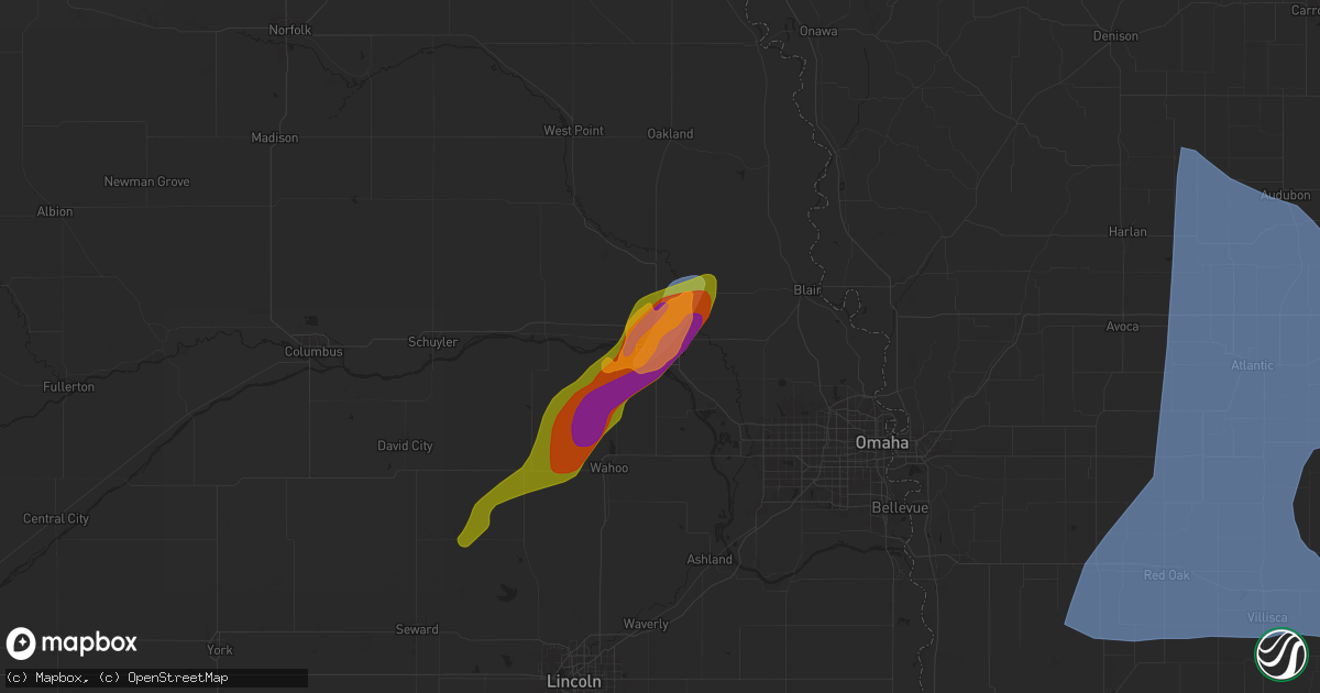
Hail Map in Fremont, NE on May 21, 2024
Get this storm
May 21 map
$229
one time, instant access
Download today. No call, no setup
Keep the $229
Bought the map and want the full workflow? Apply the entire $229 to a subscription within 7 days. None of it is wasted.
Every map, not just this one
This buys you this map. Subscription and you get every map we run, in the markets you choose from a few cities to whole states to nationwide. Plus real-time alerts the moment a storm fires.
Contact data
Name, contact info, occupancy, even credit band for addresses in the footprint. You go from where it hit to who to call.
Become the source they trust
Unlimited branding weather history reports on demand. You already have the documented answer ready for the property owner, and you are the one who showed up with it.
Property data and RoofTrace estimates
Pull up any address you have got, its value and the exact code rules for that jurisdiction, straight from One Click Code. Then RoofTrace estimates the squares, pitch, and roof value, priced the way you price.
Storm reports in Fremont, NE
Fremont, NE
| Date | Description |
|---|---|
| 05/21/202412:44 PM CDT | Report from mping: golf ball |
| 05/21/202412:44 PM CDT | Report from mping: golf ball |
| 05/21/202412:40 PM CDT | A local report indicates 65 MPH wind near 1 NNW Fremont |
| 05/21/202412:39 PM CDT | Report from mping: golf ball |
| 05/21/202412:35 PM CDT | North of the fremont airport. Delayed report. |
| 05/21/202412:34 PM CDT | Report from mping: golf ball |
| 05/21/202412:32 PM CDT | A local report indicates 1.75 inch wind near 1 NNW Fremont |
| 05/21/202412:31 PM CDT | Report from mping: golf ball |
| 05/21/202412:30 PM CDT | A local report indicates 1.75 inch wind near 2 NW Fremont |
| 05/21/202412:29 PM CDT | A local report indicates 1.75 inch wind near 1 SSW Inglewood |
All States Impacted by Hail Map on May 21, 2024
All Cities Impacted by Hail Map on May 21, 2024
- Akron, CO
- Otis, CO
- Yuma, CO
- Oakland, NE
- Lyons, NE
- Craig, NE
- Tekamah, NE
- Decatur, NE
- Onawa, IA
- Macy, NE
- Rosalie, NE
- Walthill, NE
- Sloan, IA
- Whiting, IA
- Winnebago, NE
- Kirkman, IA
- Manilla, IA
- Irwin, IA
- Harlan, IA
- Walnut, IA
- Hancock, IA
- Elk Horn, IA
- Kimballton, IA
- Oakland, IA
- Marne, IA
- Lewis, IA
- Griswold, IA
- Atlantic, IA
- Red Oak, IA
- Elliott, IA
- Essex, IA
- Emerson, IA
- Carson, IA
- Hastings, IA
- Imogene, IA
- Avoca, IA
- Henderson, IA
- Rock Port, MO
- Watson, MO
- Malvern, IA
- Brayton, IA
- Audubon, IA
- Exira, IA
- Massena, IA
- Cumberland, IA
- Anita, IA
- Stanton, IA
- Wiota, IA
- Villisca, IA
- Manning, IA
- Hamlin, IA
- Grant, IA
- Corning, IA
- Tarkio, MO
- Macedonia, IA
- Shenandoah, IA
- Fairfax, MO
- Craig, MO
- Clarinda, IA
- Skidmore, MO
- Burlington Junction, MO
- Nodaway, IA
- Adair, IA
- Bridgewater, IA
- Fontanelle, IA
- Carbon, IA
- Casey, IA
- Gravity, IA
- Prescott, IA
- Orient, IA
- Lenox, IA
- Creston, IA
- Greenfield, IA
- Menlo, IA
- Stuart, IA
- Dexter, IA
- Winterset, IA
- Earlham, IA
- De Soto, IA
- Van Meter, IA
- Adel, IA
- Cumming, IA
- Waukee, IA
- Prole, IA
- Booneville, IA
- West Des Moines, IA
- Norwalk, IA
- Indianola, IA
- Des Moines, IA
- Windsor Heights, IA
- Carlisle, IA
- Johnston, IA
- Urbandale, IA
- Clive, IA
- Pleasant Hill, IA
- Sanborn, IA
- Titonka, IA
- Larrabee, IA
- Peterson, IA
- Aurelia, IA
- Cherokee, IA
- Linn Grove, IA
- Alta, IA
- Shelby, IA
- Earling, IA
- Westphalia, IA
- Portsmouth, IA
- Panama, IA
- Sutherland, IA
- Ayrshire, IA
- Hartley, IA
- Havelock, IA
- Webb, IA
- Everly, IA
- Royal, IA
- Greenville, IA
- Dickens, IA
- Sioux Rapids, IA
- Mallard, IA
- Gillett Grove, IA
- Curlew, IA
- Laurens, IA
- Spencer, IA
- Treynor, IA
- Council Bluffs, IA
- McClelland, IA
- Minden, IA
- Primghar, IA
- Rolfe, IA
- Ruthven, IA
- Paullina, IA
- Remsen, IA
- Granville, IA
- Cleghorn, IA
- Marcus, IA
- Melvin, IA
- Herman, NE
- Hooper, NE
- Blair, NE
- Snyder, NE
- Clarkson, NE
- Dodge, NE
- Morse Bluff, NE
- Scribner, NE
- Fremont, NE
- Ames, NE
- Schuyler, NE
- Columbus, NE
- Winslow, NE
- Kennard, NE
- Linwood, NE
- Howells, NE
- Leigh, NE
- Nickerson, NE
- Arlington, NE
- Cedar Bluffs, NE
- Valley, NE
- North Bend, NE
- Rogers, NE
- Honey Creek, IA
- Bennington, NE
- Crescent, IA
- Fort Calhoun, NE
- Omaha, NE
- Missouri Valley, IA
- Defiance, IA
- Templeton, IA
- Gray, IA
- Sergeant Bluff, IA
- South Sioux City, NE
- Moville, IA
- Hornick, IA
- Bronson, IA
- Dakota City, NE
- Kingsley, IA
- Sioux City, IA
- Lawton, IA
- Salix, IA
- Hinton, IA
- Homer, NE
- Callaway, NE
- Westerville, NE
- Merna, NE
- Comstock, NE
- Ansley, NE
- Anselmo, NE
- Ord, NE
- Arcadia, NE
- Broken Bow, NE
- Eldora, IA
- Janesville, IA
- Ackley, IA
- Reinbeck, IA
- Beaman, IA
- Dike, IA
- Cedar Falls, IA
- Holland, IA
- Dewar, IA
- Iowa Falls, IA
- Tripoli, IA
- Evansdale, IA
- Morrison, IA
- Grundy Center, IA
- Sumner, IA
- Dunkerton, IA
- Aplington, IA
- Parkersburg, IA
- Hudson, IA
- Waterloo, IA
- Liscomb, IA
- New Hartford, IA
- Fairbank, IA
- Stout, IA
- Steamboat Rock, IA
- Readlyn, IA
- Conrad, IA
- Wellsburg, IA
- Denver, IA
- Waverly, IA
- Gladbrook, IA
- Marquette, NE
- Wakefield, NE
- Ithaca, NE
- Hubbard, NE
- Ulysses, NE
- Bellwood, NE
- Dunlap, IA
- Saint Paul, NE
- Bellevue, NE
- Archer, NE
- Wahoo, NE
- West Point, NE
- Central City, NE
- Battle Creek, IA
- Grand Island, NE
- Correctionville, IA
- Pierson, IA
- Milligan, NE
- Waterbury, NE
- Bruno, NE
- Wayne, NE
- Ricketts, IA
- Colon, NE
- Mead, NE
- Pisgah, IA
- Beemer, NE
- Dow City, IA
- Chapman, NE
- Saint Libory, NE
- Spalding, NE
- Silver City, IA
- Surprise, NE
- Beaver Crossing, NE
- Weston, NE
- Henderson, NE
- Bee, NE
- Dannebrog, NE
- Gretna, NE
- Wisner, NE
- Madison, NE
- Valparaiso, NE
- Pilger, NE
- Palmer, NE
- Platte Center, NE
- Hampton, NE
- Abie, NE
- Cedar Rapids, NE
- Washington, NE
- Saint Edward, NE
- Rising City, NE
- Bradshaw, NE
- Greeley, NE
- Belgrade, NE
- Albion, NE
- Mondamin, IA
- Mineola, IA
- Friend, NE
- Gresham, NE
- Papillion, NE
- Neola, IA
- Humphrey, NE
- Climbing Hill, IA
- Waco, NE
- Doniphan, NE
- Rodney, IA
- Dwight, NE
- Soldier, IA
- Boys Town, NE
- Underwood, IA
- Geneva, NE
- Waterloo, NE
- Ute, IA
- Danbury, IA
- Garland, NE
- Glenwood, IA
- Anthon, IA
- Seward, NE
- Mapleton, IA
- Creston, NE
- Duncan, NE
- Bancroft, NE
- Ceresco, NE
- Utica, NE
- Yutan, NE
- Woodbine, IA
- Giltner, NE
- Elba, NE
- Modale, IA
- York, NE
- Silver Creek, NE
- Polk, NE
- Stanton, NE
- Oto, IA
- Uehling, NE
- Goehner, NE
- McCool Junction, NE
- Charter Oak, IA
- Scotia, NE
- Pender, NE
- Little Sioux, IA
- Osceola, NE
- Prague, NE
- Clarks, NE
- La Vista, NE
- Primrose, NE
- Brainard, NE
- Staplehurst, NE
- Monroe, NE
- Aurora, NE
- Emerson, NE
- Hordville, NE
- Ashland, NE
- Benedict, NE
- North Sioux City, SD
- Moorhead, IA
- Shelby, NE
- Castana, IA
- Pacific Junction, IA
- Smithland, IA
- Denison, IA
- David City, NE
- Fairmont, NE
- Genoa, NE
- Elkhorn, NE
- Wolbach, NE
- Persia, IA
- Thurston, NE
- Arion, IA
- Logan, IA
- Alda, NE
- Malmo, NE
- Magnolia, IA
- Exeter, NE
- Jackson, NE
- Blencoe, IA
- Cordova, NE
- Carter Lake, IA
- Fullerton, NE
- Phillips, NE
- Stromsburg, NE
- Lindsay, NE
- Berwick, IA
- Altoona, IA
- Ankeny, IA
- Runnells, IA
- Woodburn, IA
- Lucas, IA
- Clay Center, NE
- Sutton, NE
- Saronville, NE
- Lacona, IA
- Osceola, IA
- Grafton, NE
- Edgar, NE
- Milo, IA
- Knoxville, IA
- Melcher Dallas, IA
- Chariton, IA
- Columbia, IA
- Pleasantville, IA
- Harvey, IA
- Pella, IA
- New Sharon, IA
- Leighton, IA
- Lynnville, IA
- Searsboro, IA
- Montezuma, IA
- Otley, IA
- Monroe, IA
- Ladora, IA
- Marengo, IA
- Victor, IA
- Guernsey, IA
- Forestburg, TX
- Amana, IA
- Norway, IA
- Williamsburg, IA
- South Amana, IA
- Homestead, IA
- North English, IA
- Muenster, TX
- Blairstown, IA
- Rosston, TX
- Raymond, NE
- Oxford, IA
- Stoughton, WI
- Oregon, WI
- Barnes City, IA
- Gainesville, TX
- Malcom, IA
- Cottage Grove, WI
- Cambridge, WI
- Deerfield, WI
- Whitesboro, TX
- Sadler, TX
- Warrensburg, NY
- Johnsburg, NY
- Athol, NY
- Adams, NE
- Sterling, NE
- Syracuse, NE
- Burr, NE
- Unadilla, NE
- Chestertown, NY
- Waverly, NE
- Alvo, NE
- Greenwood, NE
- Van Horne, IA
- Newhall, IA
- Watkins, IA
- Pottsboro, TX
- Otoe, NE
- Dunbar, NE
- Avoca, NE
- Nehawka, NE
- Weeping Water, NE
- Springfield, NE
- Elmwood, NE
- Nebraska City, NE
- Union, NE
- Murray, NE
- Plattsmouth, NE
- Hadley, NY
- Stony Creek, NY
- Diamond Point, NY
- Hamburg, IA
- Peru, NE
- Lake George, NY
- Queensbury, NY
- Murdock, NE
- Louisville, NE
- Manley, NE
- Riverton, IA
- Thurman, IA
- Farragut, IA
- Sidney, IA
- Homestead, FL
- Randolph, IA
- Hudson Falls, NY
- Tabor, IA
- Holstein, IA
- Cushing, IA
- Miami, FL
- Fort Edward, NY
- Argyle, NY
- Fort Ann, NY
- Salem, NY
- Ida Grove, IA
- Schaller, IA
- Galva, IA
- Arthur, IA
- Hartford, NY
- Catskill, NY
- Atoka, OK
- Stringtown, OK
- Granville, NY
- De Kalb, MO
- Antlers, OK
- Colony, KS
- Shushan, NY
- Cambridge, NY
- Greenwich, NY
- Carroll, IA
- Leavenworth, KS
- Storm Lake, IA
- West Concord, MN
- Fairmont, MN
- Wanamingo, MN
- Kenyon, MN
- Granada, MN
- Maryville, MO
- Clayton, OK
- Lansing, KS
- Platte City, MO
- Saint Joseph, MO
- Savannah, MO
- Muldrow, OK
- Faucett, MO
- Moyers, OK
- Gilmore City, IA
- Glidden, IA
- Arcadia, IA
- Dedham, IA
- Halbur, IA
- Coon Rapids, IA
- Scranton, IA
- Lidderdale, IA
- Lanesboro, IA
- Lake City, IA
- Churdan, IA
- Lohrville, IA
- Ralston, IA
- Rockwell City, IA
- Farnhamville, IA
- Gowrie, IA
- Snow, OK
- Parnell, MO
- Union Star, MO
- Helena, MO
- Uniontown, AR
- King City, MO
- Stanberry, MO
- Rea, MO
- Guilford, MO
- Lane, KS
- Osawatomie, KS
- Kansas City, KS
- Shawnee, KS
- Stigler, OK
- Algona, IA
- Van Buren, AR
- Alma, AR
- Fort Smith, AR
- Roland, OK
- Kansas City, MO
- Bellows Falls, VT
- Fonda, IA
- Natural Dam, AR
- Zumbrota, MN
- Waldron, MO
- West Halifax, VT
- Sheridan, MO
- Ravenwood, MO
- Epworth, IA
- Farley, IA
- Pickering, MO
- Stilwell, OK
- Olathe, KS
- Agency, MO
- Chester, AR
- Arlington, VT
- Cascade, IA
- Worthington, IA
- Nashoba, OK
- Somers, IA
- Callender, IA
- Colrain, MA
- Bernardston, MA
- Brattleboro, VT
- Alstead, NH
- Charlestown, NH
- Gardner, KS
- Afton, IA
- New Century, KS
- Grant City, MO
- Barnum, IA
- Manson, IA
- Blockton, IA
- Redding, IA
- Mountainburg, AR
- Mulberry, AR
- Iola, KS
- Cromwell, IA
- Garnett, KS
- Fontana, KS
- La Cygne, KS
- Parker, KS
- Centerville, KS
- Stewartsville, MO
- Gentry, MO
- Lenexa, KS
- Peosta, IA
- Dubuque, IA
- Durango, IA
- Meridian, TX
- Sherrill, IA
- Ozark, AR
- Dyer, AR
- Paola, KS
- Overland Park, KS
- Bucyrus, KS
- Diagonal, IA
- Greenfield, MA
- Potosi, WI
- Hazel Green, WI
- Cuba City, WI
- Dickeyville, WI
- Niota, IL
- Brookfield, MO
- Sibley, MO
- Saint Patrick, MO
- Leawood, KS
- Camden, MO
- Bogard, MO
- Tina, MO
- Rutledge, MO
- Elmer, MO
- Orrick, MO
- Edina, MO
- Dallas City, IL
- Sumner, MO
- Buckner, MO
- Independence, MO
- Galesburg, IL
- Novelty, MO
- Keokuk, IA
- Bucklin, MO
- Monmouth, IL
- Nauvoo, IL
- Knox City, MO
- La Plata, MO
- Richmond, MO
- Carrollton, MO
- Hardin, MO
- Kahoka, MO
- Hale, MO
- Hurdland, MO
- Lomax, IL
- Wayland, MO
- Norborne, MO
- Mount Ayr, IA
- La Harpe, KS
- Moran, KS
- Stilwell, KS
- Spring Hill, KS
- Benton, IA
- Kieler, WI
- Shannon City, IA
- Rush, CO
- Yoder, CO
- Dayton, IA
- Hamilton, TX
- Platteville, WI
- Lorimor, IA
- Shelburne Falls, MA
- West Bend, IA
- Whittemore, IA
- Burt, IA
- Lone Rock, IA
- Ceylon, MN
- Macksburg, IA
- Ellston, IA
- Tingley, IA
- Thayer, IA
- Jefferson, IA
- Blue Mound, KS
- Bronson, KS
- Kincaid, KS
- Westminster, VT
- Putney, VT
- Cambridgeport, VT
- Saxtons River, VT
- Hillsboro, TX
- Belmont, WI
- Rewey, WI
- Walpole, NH
- Lancaster, WI
- Marlow, NH
- South Acworth, NH
- Wells, MN
- Clarksville, AR
- Mound City, KS
- Redfield, IA
- Miami Beach, FL
- Humboldt, KS
- Truman, MN
- Martensdale, IA
- East Fairfield, VT
- Enosburg Falls, VT
- Fairfield, VT
- Sheldon, VT
- Darlington, WI
- Grand Junction, IA
- Dana, IA
- Uniontown, KS
- Mapleton, KS
- Ogden, IA
- Paton, IA
- Pleasanton, KS
- Murray, IA
- Blue Springs, MO
- Grain Valley, MO
- Hico, TX
- Bynum, TX
- East Dubuque, IL
- Saint Charles, IA
- Lenapah, OK
- Oak Grove, MO
- Lees Summit, MO
- Peru, IA
- Hindsville, AR
- Rogers, AR
- Morgan, TX
- Whitney, TX
- Clifton, TX
- Hialeah, FL
- Iredell, TX
- Alleman, IA
- Montgomery Center, VT
- Lowell, VT
- Levasy, MO
- Napoleon, MO
- Blum, TX
- Ellenburg Center, NY
- Lyon Mountain, NY
- Ellenburg Depot, NY
- Saranac, NY
- Prescott, KS
- Fort Scott, KS
- Hume, MO
- Elkhart, IA
- Cambridge, IA
- Rich Hill, MO
- Boxholm, IA
- Pilot Mound, IA
- Kopperl, TX
- Voorheesville, NY
- Fulton, KS
- Mineral Point, WI
- Foster, MO
- Malone, NY
- Butler, MO
- Redfield, KS
- Truro, IA
- New Virginia, IA
- Coffeyville, KS
- Nevada, IA
- North Walpole, NH
- Westfield, VT
- South Deerfield, MA
- Commerce, TX
- Wolfe City, TX
- Greenville, TX
- Winslow, AR
- Princeton, MO
- Cainsville, MO
- Mercer, MO
- Altamont, NY
- Tulsa, OK
- Sand Springs, OK
- Henrietta, MO
- Prue, OK
- Dodgeville, WI
- Wellington, MO
- Ackworth, IA
- Hartford, IA
- Edna, KS
- Zearing, IA
- Sunderland, MA
- Klondike, TX
- Cooper, TX
- Enloe, TX
- Bevington, IA
- Mitchellville, IA
- Prairie City, IA
- Colfax, IA
- Newton, IA
- Vinita, OK
- Waldron, AR
- Heavener, OK
- Hodgen, OK
- Girard, KS
- Bristow, OK
- Drumright, OK
- Deerfield, MA
- Cumby, TX
- Campbell, TX
- Conway, MA
- Oologah, OK
- Claremore, OK
- Ames, IA
- Sperry, OK
- Swan, IA
- Baxter, IA
- Owasso, OK
- Lineville, IA
- Kellogg, IA
- Urich, MO
- Bondurant, IA
- Grinnell, IA
- Gilman, IA
- Laurel, IA
- Catoosa, OK
- Kellyville, OK
- Sapulpa, OK
- Marshalltown, IA
- Ferguson, IA
- Haverhill, IA
- Melbourne, IA
- Wheeler, WI
- Chelsea, OK
- Mannford, OK
- Mindenmines, MO
- Franklin, KS
- Mulberry, KS
- Arma, KS
- Oark, AR
- Geneva, IA
- Radcliffe, IA
- Alden, IA
- Ridgeway, WI
- Promise City, IA
- Melrose, IA
- Plano, IA
- Russell, IA
- Lake Creek, TX
- Clio, IA
- Allerton, IA
- Paris, TX
- Witts Springs, AR
- Turners Falls, MA
- Pittsburg, KS
- Amoret, MO
- Hubbard, IA
- Roland, IA
- McCallsburg, IA
- Clinton, MO
- Ridgeway, MO
- Pelsor, AR
- Collinsville, OK
- Appleton City, MO
- Rockville, MO
- Spring Green, WI
- Richards, MO
- Schell City, MO
- Glenville, MN
- Austin, MN
- Lyle, MN
- Rose Creek, MN
- Hollandale, MN
- Albert Lea, MN
- Brownsdale, MN
- Waltham, MN
- Lansing, MN
- Blooming Prairie, MN
- Corydon, IA
- Albia, IA
- Moravia, IA
- Montour, IA
- Garwin, IA
- Le Grand, IA
- Tama, IA
- Toledo, IA
- Milan, MO
- Green City, MO
- Green Castle, MO
- Unionville, MO
- Jenks, OK
- Glenpool, OK
- Hector, AR
- Pattonville, TX
- Deport, TX
- Skiatook, OK
- Memphis, MO
- Vera, OK
- Ramona, OK
- Osceola, MO
- Lowry City, MO
- Cleveland, OK
- Blairstown, MO
- Big Cabin, OK
- Marble Rock, IA
- Dumont, IA
- Broken Arrow, OK
- Lovilia, IA
- Livonia, MO
- Worthington, MO
- Bixby, OK
- Clutier, IA
- Dysart, IA
- Traer, IA
- Buckingham, IA
- Lincoln, IA
- Anamosa, IA
- Olin, IA
- Center Junction, IA
- La Porte City, IA
- Sargeant, MN
- Harmony, MN
- Elkton, MN
- Preston, MN
- Wykoff, MN
- Grand Meadow, MN
- Taopi, MN
- Spring Valley, MN
- Ostrander, MN
- Le Roy, MN
- Adams, MN
- Dexter, MN
- Kasson, MN
- Eyota, MN
- Hayfield, MN
- Racine, MN
- Fountain, MN
- Lanesboro, MN
- Byron, MN
- Stewartville, MN
- Chatfield, MN
- Rochester, MN
- Eddyville, IA
- Mechanicsville, IA
- Morley, IA
- Stitzer, WI
- Deepwater, MO
- Cresco, IA
- Lime Springs, IA
- Reasnor, IA
- Sully, IA
- Bussey, IA
- West Liberty, IA
- Nichols, IA
- Depew, OK
- Walker, MO
- Cantril, IA
- Arbela, MO
- Mount Sterling, IA
- Keosauqua, IA
- Booneville, AR
- Derby, IA
- Lisbon, IA
- Altura, MN
- Pryor, OK
- Inola, OK
- Monticello, IA
- Oskaloosa, IA
- Dover, MN
- Saint Charles, MN
- Utica, MN
- Plainview, MN
- Atalissa, IA
- Tipton, IA
- Mabel, MN
- Rollingstone, MN
- Canton, MN
- Rushford, MN
- Lewiston, MN
- Peterson, MN
- Minnesota City, MN
- Fountain City, WI
- Fort Atkinson, IA
- Mount Vernon, IA
- Decorah, IA
- West Branch, IA
- Montfort, WI
- Fennimore, WI
- Highland, WI
- Muscoda, WI
- Warsaw, MO
- West Union, IA
- Rose Hill, IA
- Hopkinton, IA
- Beacon, IA
- University Park, IA
- Marceline, MO
- Wyoming, IA
- Onslow, IA
- Livingston, WI
- Concord, NH
- Coweta, OK
- Boscobel, WI
- Blue River, WI
- Waucoma, IA
- Saint Lucas, IA
- Calmar, IA
- Massena, NY
- Hogansburg, NY
- Bonaparte, IA
- Clarence, IA
- Lowden, IA
- Welch, OK
- Cochrane, WI
- Winona, MN
- Spring Grove, MN
- Houston, MN
- Caledonia, MN
- Hillsboro, IA
- Chilhowee, MO
- Glenwood, MO
- Chouteau, OK
- Linden, WI
- Cobb, WI
- Garrison, IA
- Raymond, IA
- Gilbertville, IA
- Jesup, IA
- Trempealeau, WI
- Dakota, MN
- Arcadia, WI
- Dodge, WI
- What Cheer, IA
- Gibson, IA
- Deep River, IA
- Bernard, IA
- Beggs, OK
- Oxford Junction, IA
- Lancaster, MO
- Bloomfield, IA
- Coatsville, MO
- Bombay, NY
- Cazenovia, WI
- Richland Center, WI
- Bow, NH
- Lincoln, MO
- Montrose, MO
- Edwards, MO
- Cole Camp, MO
- New Boston, NH
- Goffstown, NH
- Kirksville, MO
- Greentop, MO
- Lone Rock, WI
- Chelsea, IA
- Brooklyn, IA
- New Cambria, MO
- Okmulgee, OK
- Tracy, IA
- Blair, WI
- La Crescent, MN
- Brownsville, MN
- Hokah, MN
- Galesville, WI
- Ettrick, WI
- Whitehall, WI
- Onalaska, WI
- Independence, WI
- Holmen, WI
- Avoca, WI
- Monmouth, IA
- Bellevue, IA
- Maquoketa, IA
- Zwingle, IA
- Baldwin, IA
- La Motte, IA
- Scales Mound, IL
- Galena, IL
- Shullsburg, WI
- Ethel, MO
- Bevier, MO
- Callao, MO
- Atlanta, MO
- Stover, MO
- Versailles, MO
- Baring, MO
- Brashear, MO
- Vining, IA
- Elberon, IA
- Stockton, MO
- Benton, WI
- Liberal, MO
- Central City, IA
- Humansville, MO
- La Valle, WI
- Hillpoint, WI
- Downing, MO
- Wagoner, OK
- Atkins, IA
- Brandon, IA
- Vinton, IA
- Mount Auburn, IA
- Shellsburg, IA
- Columbus City, IA
- Columbus Junction, IA
- Oran, IA
- Urbana, IA
- Walker, IA
- Hazleton, IA
- Rowley, IA
- Oelwein, IA
- Center Point, IA
- Independence, IA
- Stoddard, WI
- La Crosse, WI
- Coon Valley, WI
- Chaseburg, WI
- West Salem, WI
- Black River Falls, WI
- Bangor, WI
- Melrose, WI
- Mindoro, WI
- Taylor, WI
- Hanover, IL
- Conesville, IA
- Letts, IA
- Novinger, MO
- Sheldon, MO
- Warren, IL
- Morris, OK
- Mansfield, AR
- Barnett, MO
- Climax Springs, MO
- Gravois Mills, MO
- Idabel, OK
- Clarksville, TX
- Plain, WI
- Arena, WI
- Weaubleau, MO
- Squires, MO
- Rose, OK
- Locust Grove, OK
- Gibbs, MO
- Geneseo, IL
- Peggs, OK
- Delmar, IA
- Walford, IA
- Hulbert, OK
- Moscow, IA
- Wilton, IA
- Muscatine, IA
- Lone Tree, IA
- Bennett, IA
- Elizabeth, IL
- Keystone, IA
- Cedar Rapids, IA
- Palo, IA
- Fairfax, IA
- Winthrop, IA
- Toddville, IA
- Maynard, IA
- Fayette, IA
- Stanley, IA
- Arlington, IA
- Quasqueton, IA
- Aurora, IA
- Luzerne, IA
- Middle Amana, IA
- Conroy, IA
- Swisher, IA
- Coggon, IA
- Wheatland, IA
- New Liberty, IA
- Sparta, WI
- Rockland, WI
- Lost Nation, IA
- Gratiot, WI
- Apple River, IL
- Hiawatha, IA
- Alburnett, IA
- Masonville, IA
- Lamont, IA
- Robins, IA
- Marion, IA
- Manchester, IA
- Ryan, IA
- Wadena, IA
- Volga, IA
- Greeley, IA
- Edgewood, IA
- Strawberry Point, IA
- Dundee, IA
- North Liberty, IA
- Solon, IA
- Tahlequah, OK
- Flemington, MO
- Wheatland, MO
- Iowa City, IA
- Coralville, IA
- Okemah, OK
- Boynton, OK
- Hollandale, WI
- Barneveld, WI
- Blanchardville, WI
- South Wayne, WI
- Argyle, WI
- Eldon, MO
- Rocky Mount, MO
- Lamar, AR
- New Blaine, AR
- Scranton, AR
- Andrew, IA
- Ava, MO
- Kalona, IA
- Polk, MO
- Pittsburg, MO
- Salina, OK
- Kansas, OK
- Rolla, MO
- Loganville, WI
- Sauk City, WI
- North Freedom, WI
- Norwood, MO
- Drury, MO
- Woodford, WI
- Ely, IA
- Blue Mounds, WI
- Delhi, IA
- Hermitage, MO
- Coleman, TX
- Macon, MO
- Proctor, OK
- Valera, TX
- Haworth, OK
- New Glarus, WI
- Mazomanie, WI
- Belleville, WI
- Paris, AR
- Monticello, WI
- Prairie Du Sac, WI
- Mount Horeb, WI
- Springville, IA
- Olean, MO
- London, AR
- Bolivar, MO
- Monroe, WI
- Urbana, MO
- Santa Anna, TX
- Oktaha, OK
- Merrillan, WI
- Alma Center, WI
- Willard, WI
- Humbird, WI
- Neillsville, WI
- Hixton, WI
- Fairchild, WI
- Osseo, WI
- Warrens, WI
- Tomah, WI
- Muskogee, OK
- Chili, WI
- Marshfield, WI
- Greenwood, WI
- Granton, WI
- Pittsville, WI
- Stratford, WI
- Hewitt, WI
- Arpin, WI
- Loyal, WI
- Spencer, WI
- Unity, WI
- Vesper, WI
- Verona, WI
- Madison, WI
- Middleton, WI
- Waunakee, WI
- Bagley, WI
- Cross Plains, WI
- Stockton, IA
- Glen Haven, WI
- Gays Mills, WI
- Martelle, IA
- Half Way, MO
- Leoti, KS
- Council Hill, OK
- West Plains, MO
- Pomona, MO
- Dover, AR
- Henley, MO
- Lanark, IL
- Shannon, IL
- Durant, IA
- Spragueville, IA
- Savanna, IL
- Nora, IL
- Stockton, IL
- Auburndale, WI
- Milladore, WI
- Wisconsin Rapids, WI
- Rudolph, WI
- Athens, WI
- Edgar, WI
- Medford, WI
- Junction City, WI
- Mosinee, WI
- Abbotsford, WI
- Colby, WI
- Browntown, WI
- Hillsboro, MO
- Marienthal, KS
- Deerfield, KS
- Holcomb, KS
- Leonard, MO
- Cassville, WI
- Saint Thomas, MO
- Westphalia, MO
- Meta, MO
- Koeltztown, MO
- Freeburg, MO
- Delaware, AR
- Tunas, MO
- Louisburg, MO
- Holy Cross, IA
- Guttenberg, IA
- Saint Elizabeth, MO
- New Vienna, IA
- Dyersville, IA
- Bloomington, WI
- Richwoods, MO
- Dittmer, MO
- De Soto, MO
- Grand Mound, IA
- Dixon, IA
- Calamus, IA
- Burkett, TX
- Marathon, WI
- Custer, WI
- Stevens Point, WI
- Rosholt, WI
- Merrill, WI
- Rib Lake, WI
- Schofield, WI
- Brokaw, WI
- Wausau, WI
- Rothschild, WI
- Pearl, IL
- Nebo, IL
- Charlotte, IA
- Preston, IA
- Russellville, AR
- Scott City, KS
- Garden City, KS
- Bangs, TX
- Brownwood, TX
- North Buena Vista, IA
- Arlington, WI
- Deforest, WI
- Barnhart, MO
- Checotah, OK
- Linn, MO
- Loose Creek, MO
- Newark, MO
- Belle, MO
- Lamar, MO
- Roodhouse, IL
- Patterson, IL
- Hillview, IL
- Winchester, IL
- Murrayville, IL
- Fenton, MO
- Saint Louis, MO
- Imperial, MO
- Arnold, MO
- Chapin, IL
- Jacksonville, IL
- Franklin, IL
- Alexander, IL
- Woodson, IL
- Pleasant Plains, IL
- Ashland, IL
- New Berlin, IL
- Waverly, IL
- Eland, WI
- Aniwa, WI
- Birnamwood, WI
- Wittenberg, WI
- Hatley, WI
- Tigerton, WI
- Ringle, WI
- Gleason, WI
- Deerbrook, WI
- Antigo, WI
- Irma, WI
- Miles, IA
- Lena, IL
- Kent, IL
- Winslow, IL
- Orangeville, IL
- McConnell, IL
- Albany, WI
- Columbia, IL
- East Saint Louis, IL
- East Carondelet, IL
- Dupo, IL
- Havana, AR
- Bland, MO
- Contoocook, NH
- Warner, OK
- Francestown, NH
- Eldridge, MO
- Camdenton, MO
- Macks Creek, MO
- Suncook, NH
- Atkins, AR
- Danville, AR
- Henryetta, OK
- Weleetka, OK
- Wetumka, OK
- Dane, WI
- Brooklyn, WI
- Evansville, WI
- Mcfarland, WI
- Windsor, WI
- Morrisonville, WI
- Sun Prairie, WI
- Rio, WI
- Lodi, WI
- Early, TX
- Marshall, WI
- Columbus, WI
- Zephyr, TX
- Elcho, WI
- Bryant, WI
- Pelican Lake, WI
- Summit Lake, WI
- Pearson, WI
- Crandon, WI
- Fox Lake, WI
- Waupun, WI
- Solgohachia, AR
- Hattieville, AR
- Owensville, MO
- Rosebud, MO
- Buffalo, MO
- House Springs, MO
- Mullin, TX
- Mattoon, WI
- Neopit, WI
- Pickerel, WI
- Elton, WI
- Laona, WI
- White Lake, WI
- Bowler, WI
- Townsend, WI
- Wabeno, WI
- Keshena, WI
- Mountain, WI
- Waterloo, WI
- Lake Mills, WI
- Reeseville, WI
- Watertown, WI
- Fall River, WI
- Jefferson, WI
- Fort Atkinson, WI
- Johnson Creek, WI
- Edgerton, WI
- Janesville, WI
- Brodhead, WI
- Juda, WI
- Center Ridge, AR
- Springfield, AR
- Gerald, MO
- New Haven, MO
- De Witt, IA
- Rover, AR
- Ola, AR
- Plainview, AR
- Dustin, OK
- Goose Lake, IA
- Lebanon, MO
- Iola, WI
- Amherst Junction, WI
- Embarrass, WI
- Clintonville, WI
- Marion, WI
- Ogdensburg, WI
- Shawano, WI
- Caroline, WI
- Gresham, WI
- Leopolis, WI
- Tilleda, WI
- Bear Creek, WI
- Shiocton, WI
- Bonduel, WI
- Gillett, WI
- Plover, WI
- Beaver Dam, WI
- Burnett, WI
- Juneau, WI
- Lowell, WI
- Clyman, WI
- Randolph, WI
- Poynette, WI
- Bryant, IA
- Greenbrier, AR
- Damascus, AR
- Eufaula, OK
- Clinton, IA
- Sabula, IA
- Leslie, MO
- Porum, OK
- Quitman, AR
- Guy, AR
- Goldthwaite, TX
- Mount Vernon, AR
- Rose Bud, AR
- Enola, AR
- Mount Carroll, IL
- Pearl City, IL
- Whitefield, OK
- Quinton, OK
- Kinta, OK
- Mccurtain, OK
- Evant, TX
- Freeport, IL
- Searcy, AR
- Romance, AR
- Mayville, WI
- Oakfield, WI
- Brownsville, WI
- Lomira, WI
- Winona, MO
- Eminence, MO
- Sheffield, IL
- Judsonia, AR
- Kensett, AR
- Ellington, MO
- Redford, MO
- New Bedford, IL
- Walnut, IL
- Tampico, IL
- Bald Knob, AR
- Beloit, WI
- Annapolis, MO
- Arcadia, MO
- Warrenton, MO
- Lesterville, MO
- Marquand, MO
- Alexander, AR
- Benton, AR
- Old Monroe, MO
- Fredericktown, MO
- O'Fallon, MO
- Ixonia, WI
- Harmon, IL
- Little Rock, AR
- Foristell, MO
- Wentzville, MO
- Moscow Mills, MO
- Troy, MO
- Wright City, MO
- Capron, IL
- Bryant, AR
- Mabelvale, AR
- Harvard, IL
- McCrory, AR
- Sharon, WI
- Darien, WI
- Walworth, WI
- Eagle, WI
- Golden Eagle, IL
- Dousman, WI
- Ironton, MO
- Wynne, AR
- Greenville, MO
- Pewaukee, WI
- Wales, WI
- Delafield, WI
- Waukesha, WI
- Keota, OK
- Winfield, MO
- Fletcher, MO
- Vulcan, MO
- Marthasville, MO
- Millstadt, IL
- Scott, AR
- England, AR
- Jefferson City, MO
- Patterson, MO
- Silva, MO
- Keo, AR
- Lonoke, AR
- Bokoshe, OK
- Spiro, OK
- Carlisle, AR
- Humnoke, AR
- Stuttgart, AR
- Ulm, AR
- Dixon, KY
- Morganfield, KY
- Roe, AR
- Junction, IL
- Henderson, KY
- Arcadia, MI
- Bear Lake, MI
- Reed, KY
- Spottsville, KY
- Casscoe, AR
- Birch Tree, MO
- Alton, MO
- Owensboro, KY
- Richland, IN
- Merom, IN
- Mount Ida, AR
- Sims, AR
- Pencil Bluff, AR
- Fremont, MO
- Walcott, IA
- Story, AR
- Donahue, IA
- Jessieville, AR
- Mountain Pine, AR
- Hot Springs Village, AR
- Bonnerdale, AR
- Royal, AR
- Hot Springs National Park, AR
- Pearcy, AR
- Lonsdale, AR
- Malvern, AR
- Hensley, AR
- Bauxite, AR
- Hydro, OK
- Yukon, OK
- Okarche, OK
- Hinton, OK
- Commiskey, IN
- North Vernon, IN
- Dupont, IN
- Calumet, OK
- Kingfisher, OK
- Piedmont, OK
- Butlerville, IN
- El Reno, OK
- Marshall, OK
- S Coffeyville, OK
- Oklahoma City, OK
- Edmond, OK
- Orlando, OK
- Stillwater, OK
- Mulhall, OK
- Geary, OK
- Meeker, OK
- Norwalk, WI
- Cashton, WI
- Westby, WI
- Necedah, WI
- Babcock, WI
- Nekoosa, WI
- Camp Douglas, WI
- Port Edwards, WI
- Plainfield, WI
- Bancroft, WI
- Almond, WI
- Amherst, WI
- Waupaca, WI
- Nelsonville, WI
- Weyauwega, WI
- Scandinavia, WI
- Horicon, WI
- Rosendale, WI
- Fond Du Lac, WI
- Brandon, WI
- Eldorado, WI
- Markesan, WI
- Ripon, WI
- Oshkosh, WI
- Van Dyne, WI
- Pickett, WI
- Hortonville, WI
- Manawa, WI
- New London, WI
- Menasha, WI
- Larsen, WI
- Neenah, WI
- Appleton, WI
- Kaukauna, WI
- Brillion, WI
- Sherwood, WI
- Hilbert, WI
- Combined Locks, WI
- Greenville, WI
- De Pere, WI
- Wrightstown, WI
- Little Chute, WI
- Kimberly, WI
- Greenleaf, WI
- Winneconne, WI
- Omro, WI
- Butte Des Morts, WI
- Fremont, WI
- Seymour, WI
- Oneida, WI
- Green Bay, WI
- Black Creek, WI
- Suamico, WI
- Pulaski, WI
- Sobieski, WI
- Abrams, WI
- Little Suamico, WI
- Oconto Falls, WI
- Krakow, WI
- Green Valley, WI
- Suring, WI
- Cecil, WI
- Nichols, WI
- Alma, WI
- Elgin, MN
- Lakewood, WI
- Casco, WI
- Algoma, WI
- Forestville, WI
- Luxemburg, WI
- New Franken, WI
- Brussels, WI
- Oconto, WI
- Sturgeon Bay, WI
- Egg Harbor, WI
- Baileys Harbor, WI
- Ellison Bay, WI
- Dunbar, WI
- Carney, MI
- Coleman, WI
- Norway, MI
- Wausaukee, WI
- Perronville, MI
- Hermansville, MI
- Pembine, WI
- Stephenson, MI
- Spalding, MI
- Amberg, WI
- Sister Bay, WI
- Loretto, MI
- Vulcan, MI
- Wallace, MI
- Fish Creek, WI
- Powers, MI
- Foster City, MI
- Crivitz, WI
- Nadeau, MI
- Niagara, WI
- Porterfield, WI
- Ephraim, WI
- Pound, WI
- Lena, WI
- Marinette, WI
- Ingalls, MI
- Peshtigo, WI
- Daggett, MI
- Menominee, MI
- Wilson, MI
- Iron Mountain, MI
- Athelstane, WI
- Quinnesec, MI
- Goodman, WI
- Dalton, WI
- Friesland, WI
- Poy Sippi, WI
- Endeavor, WI
- Kingston, WI
- Berlin, WI
- Wild Rose, WI
- Pardeeville, WI
- Westfield, WI
- Redgranite, WI
- Pine River, WI
- Fairwater, WI
- Montello, WI
- Oxford, WI
- Neshkoro, WI
- Marquette, WI
- Cambria, WI
- Packwaukee, WI
- Green Lake, WI
- Wautoma, WI
- Princeton, WI
- Catawba, WI
- Owen, WI
- Withee, WI
- Lublin, WI
- Boyd, WI
- Thorp, WI
- Stanley, WI
- Fall Creek, WI
- Kennan, WI
- Hawkins, WI
- Gilman, WI
- Cornell, WI
- Cadott, WI
- Holcombe, WI
- Westboro, WI
- Sheldon, WI
- Augusta, WI
- Glen Flora, WI
- Jim Falls, WI
- Dorchester, WI
- Portage, WI
- Doylestown, WI
- Florence, WI
- Crystal Falls, MI
- Kingsford, MI
- Argonne, WI
- Armstrong Creek, WI
- Long Lake, WI
- Fence, WI
- Skandia, MI
- Gwinn, MI
- Little Lake, MI
- Felch, MI
- Escanaba, MI
- Marquette, MI
- Bark River, MI
- Cornell, MI
- Rock, MI
- Gladstone, MI
- Perkins, MI
- Washington Island, WI
- Rapid River, MI
- Trenary, MI
- Wells, MI
- Chatham, MI


