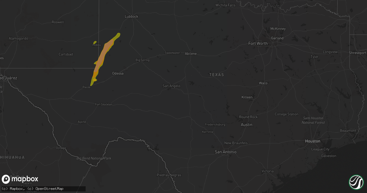
Hail Map in Texas on May 21, 2016
Get this storm
May 21 map
$229
one time, instant access
Download today. No call, no setup
Keep the $229
Bought the map and want the full workflow? Apply the entire $229 to a subscription within 7 days. None of it is wasted.
Every map, not just this one
This buys you this map. Subscription and you get every map we run, in the markets you choose from a few cities to whole states to nationwide. Plus real-time alerts the moment a storm fires.
Contact data
Name, contact info, occupancy, even credit band for addresses in the footprint. You go from where it hit to who to call.
Become the source they trust
Unlimited branding weather history reports on demand. You already have the documented answer ready for the property owner, and you are the one who showed up with it.
Property data and RoofTrace estimates
Pull up any address you have got, its value and the exact code rules for that jurisdiction, straight from One Click Code. Then RoofTrace estimates the squares, pitch, and roof value, priced the way you price.
Storm reports in Texas
Texas
| Date | Description |
|---|---|
| 05/21/20166:53 PM CDT | Thunderstorm wind damage reported at fm 1008 and fm 2331 just west of dayton lakes estates. |
| 05/21/20166:37 PM CDT | A local report indicates 1.00 inch wind near 4 SW HARTLEY |
| 05/21/20166:36 PM CDT | Barn torn up on cr 521 and cr 729 just southeast of sweeney. Possible tornado. |
| 05/21/20166:24 PM CDT | A local report indicates 1.75 inch wind near KERMIT |
| 05/21/20166:17 PM CDT | Quarter size hail reported 9.2 miles west of hartley on fm 998...20 to 30 mph wind...and fair amount of hail but not enough to cover the road. |
| 05/21/20166:15 PM CDT | Metal carport blown over in manvel. |
| 05/21/20166:13 PM CDT | Dime to quarter hail |
| 05/21/20166:00 PM CDT | Trees down in crosby...also marble sized hail. |
| 05/21/20165:57 PM CDT | Reported by the wink asos |
| 05/21/20165:45 PM CDT | Mostly dime to nickel size hail was falling with a few hailstones up to quarter size. |
| 05/21/20165:45 PM CDT | Dime to quarter sized hail at beltway 8 and interstate 10. |
| 05/21/20165:12 PM CDT | Mostly dime to penny size hail was falling with a few ping pong ball size hailstones. |
| 05/21/20164:21 PM CDT | Trees down on road at iowa lane just south of highway 6. |
| 05/20/201610:57 PM CDT | Two inch diameter hail measured with a tape measure. |
| 05/20/201610:54 PM CDT | At least half dollar size hail. Road covered in hail. |
| 05/20/201610:52 PM CDT | Nickel to quarter size hail. |
| 05/20/20169:28 PM CDT | Nickel to quarter size hail measured with a ruler. Hail increased to quarter size since the last report at 925 pm cdt. |
| 05/20/20169:14 PM CDT | Golf ball size hail on the southeast side of dalhart. |
| 05/20/20169:12 PM CDT | Ping pong ball size hail on the south side of dalhart. |
| 05/20/20169:11 PM CDT | Quarter to golf ball size hail. |
| 05/20/20169:10 PM CDT | Hail the size from quarters to golf balls reported at 6th and keeler in dalhart. |
| 05/20/20169:09 PM CDT | A local report indicates 1.00 inch wind near DALHART |
| 05/20/20168:28 PM CDT | Hail has increased to half dollar size since the previous report at this location. Road and yards covered with hail. |
| 05/20/20168:27 PM CDT | Hail has increased to golf ball size since the time of the last report at this same location. |
| 05/20/20168:26 PM CDT | Several hail stones found on the ground that measured 1.75 inches in diameter. Time of event is estimated by radar. |
| 05/20/20168:20 PM CDT | Nickel to quarter size hail. |
| 05/20/20168:20 PM CDT | Severalirrigation pivots overturned. |
| 05/20/20168:20 PM CDT | Dime to quarter size hail. |
| 05/20/20168:17 PM CDT | A local report indicates 2.00 inch wind near 7 S SEAGRAVES |
| 05/20/20168:10 PM CDT | A local report indicates 61 MPH wind near 7 S SEAGRAVES |
| 05/20/20168:07 PM CDT | Power poles down on us 180 |
| 05/20/20168:07 PM CDT | Numerous house and auto windows broken due to hail. |
| 05/20/20168:00 PM CDT | A local report indicates 65 MPH wind near 1 SW SEAGRAVES |
| 05/20/20167:54 PM CDT | Quarter size to tennis ball size hail. |
| 05/20/20167:49 PM CDT | 0.95 inch diameter hail measured with calipers. |
| 05/20/20167:49 PM CDT | Kbmt relayed public report of one inch hail in saratoga. Video also posted to social media. |
| 05/20/20167:47 PM CDT | Ping pong ball to golf ball size hail. |
| 05/20/20167:44 PM CDT | A local report indicates 2.00 inch wind near 3 S HARTLEY |
| 05/20/20167:44 PM CDT | A local report indicates 1.00 inch wind near HARTLEY |
| 05/20/20167:40 PM CDT | A local report indicates 1.75 inch wind near 3 S HARTLEY |
| 05/20/20167:21 PM CDT | Golf ball size hail covering the road in hartley. |
| 05/20/20167:18 PM CDT | A local report indicates 1.50 inch wind near 1 ESE SIMMS |
| 05/20/20167:17 PM CDT | Dime with some quarter size hail. On u.s. 385. |
| 05/20/20167:16 PM CDT | Quarter to ping pong ball size hail. |
| 05/20/20167:11 PM CDT | Ping pong sized hail in jones creek. |
| 05/20/20167:10 PM CDT | Half dollar to hen egg hail. |
| 05/20/20167:10 PM CDT | A local report indicates 1.50 inch wind near 1 ESE SIMMS |
| 05/20/20167:07 PM CDT | Update to the last report of quarters at this location. Hail size is now up to half dollars. |
| 05/20/20167:04 PM CDT | A local report indicates 1.00 inch wind near 4 SW HARTLEY |
All States Impacted by Hail Map on May 21, 2016
Cities Impacted by Hail Map on May 21, 2016
- Winona, KS
- Leoti, KS
- Edson, KS
- Levant, KS
- Colby, KS
- Brewster, KS
- Tribune, KS
- Galena Park, TX
- Houston, TX
- Crosby, TX
- Dayton, TX
- Channelview, TX
- Pasadena, TX
- Brazoria, TX
- Freeport, TX
- Sweeny, TX
- Hull, TX
- Kountze, TX
- Batson, TX
- Liberty, TX
- Sour Lake, TX
- Saratoga, TX
- Boonville, NC
- Dobson, NC
- East Bend, NC
- Lewisville, NC
- Hamptonville, NC
- Jonesville, NC
- Yadkinville, NC
- Malta, MT
- Zortman, MT
- Jordan, MT
- Sand Springs, MT
- Fort Peck, MT
- Nashua, MT
- Brusett, MT
- Cohagen, MT
- Angela, MT
- Saco, MT
- Hinsdale, MT
- Texico, NM
- Conchas Dam, NM
- Tucumcari, NM
- Clovis, NM
- House, NM
- Mcalister, NM
- Portales, NM
- Worden, MT
- Custer, MT
- Laurel, MT
- Edgar, MT
- Billings, MT
- Ingomar, MT
- Joliet, MT
- Shepherd, MT
- Molt, MT
- Bridger, MT
- Musselshell, MT
- Columbus, MT
- Big Timber, MT
- Busby, MT
- Forsyth, MT
- Rosebud, MT
- Sheridan, WY
- Decker, MT
- Birney, MT
- Clearmont, WY
- Dalhart, TX
- Hartley, TX
- Channing, TX
- Hereford, TX
- Bovina, TX
- Friona, TX
- Vega, TX
- Jal, NM
- Kermit, TX
- Seminole, TX
- Andrews, TX
- Seagraves, TX
- Wink, TX
- Hobbs, NM
- Monahans, TX
- Pyote, TX
- Brownfield, TX
- Loop, TX
- Buffalo, WY
- Banner, WY
- Arvada, WY
- Glenrock, WY
- Gillette, WY
- Douglas, WY
- Red Lodge, MT
- Roberts, MT
- Wallace, KS
- Star, NC
- Mosquero, NM
- Siler City, NC
- Pittsboro, NC
- Waller, TX
- Bellville, TX
- Navasota, TX
- Hempstead, TX
- Chappell Hill, TX
- Lame Deer, MT
- Acton, MT
- Park City, MT
- Sanford, NC
- Rogers, NM
- Port Arthur, TX
- Beaumont, TX
- Winnie, TX
- Roundup, MT
- Abbeville, LA
- Vidor, TX
- Rosharon, TX
- Liberty, NC
- Staley, NC
- Hamshire, TX
- Goldthwaite, TX
- Midwest, WY
- Edgerton, WY
- Manvel, TX
- Pearland, TX
- Conyers, GA
- College Station, TX
- Bryan, TX
- Lovington, NM
- Rapelje, MT
- Key Biscayne, FL
- Bay City, TX
- Kaycee, WY
- South Houston, TX
- Wright, WY
- Advance, NC
- Mocksville, NC
- Colstrip, MT
- San Jon, NM
- Alvin, TX
- Liverpool, TX
- Deer Park, TX
- Baytown, TX
- Highlands, TX
- La Porte, TX
- Galliano, LA
- Hialeah, FL
- Miami, FL
- Hillsboro, GA
- Gray, GA
- Tahoka, TX
- Wilson, TX
- Mullin, TX
- Plantersville, TX
- New Ulm, TX
- Cat Spring, TX
- Miami Beach, FL
- Casper, WY
- Stockbridge, GA
- Lithonia, GA
- Damon, TX
- West Columbia, TX
- Bloomington, NE
- Fromberg, MT
- Snow Camp, NC
- Haddock, GA
- Kaplan, LA
- Yoakum, TX
- Charlotte, NC
- Kensington, KS
- Pep, NM


