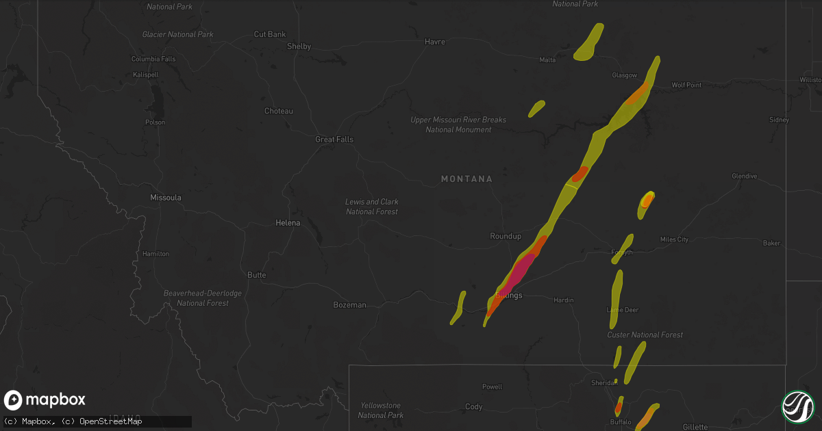
Hail Map in Montana on May 21, 2016
Get this storm
May 21 map
$229
one time, instant access
Download today. No call, no setup
Keep the $229
Bought the map and want the full workflow? Apply the entire $229 to a subscription within 7 days. None of it is wasted.
Every map, not just this one
This buys you this map. Subscription and you get every map we run, in the markets you choose from a few cities to whole states to nationwide. Plus real-time alerts the moment a storm fires.
Contact data
Name, contact info, occupancy, even credit band for addresses in the footprint. You go from where it hit to who to call.
Become the source they trust
Unlimited branding weather history reports on demand. You already have the documented answer ready for the property owner, and you are the one who showed up with it.
Property data and RoofTrace estimates
Pull up any address you have got, its value and the exact code rules for that jurisdiction, straight from One Click Code. Then RoofTrace estimates the squares, pitch, and roof value, priced the way you price.
Storm reports in Montana
Montana
| Date | Description |
|---|---|
| 05/21/20166:49 PM CDT | 64 mph wind gusts record at the jordan airport asos |
| 05/21/20166:30 PM CDT | 70-80 mph wind gust |
| 05/21/20165:30 PM CDT | Quarter sized hail fell between 430pm-500pm |
| 05/21/20165:30 PM CDT | A local report indicates 1.00 inch wind near MELSTONE |
| 05/21/20165:27 PM CDT | Trees down... Including large old trees broken off by the wind. Trailer house off its foundation and owner lost his garage. Large irrigation sprinklers were blown over |
| 05/21/20165:10 PM CDT | Strong winds with the largest hail up to the size of quarters. |
| 05/21/20165:10 PM CDT | Strong winds with the largest hail up to the size of quarters. |
| 05/21/20164:45 PM CDT | A local report indicates 1.00 inch wind near 5 E ROUNDUP |
| 05/21/20164:25 PM CDT | A local report indicates 1.00 inch wind near BILLINGS |
| 05/21/20164:25 PM CDT | Between golf ball and hen egg. |
| 05/21/20164:18 PM CDT | A local report indicates 61 MPH wind near 17 S FORT SMITH |
| 05/21/20164:17 PM CDT | A local report indicates 2.00 inch wind near SHEPHERD |
| 05/21/20164:15 PM CDT | A local report indicates 1.75 inch wind near 6 N BILLINGS |
| 05/21/20164:10 PM CDT | A local report indicates 1.75 inch wind near BILLINGS |
| 05/21/20164:10 PM CDT | A local report indicates 1.75 inch wind near 3 N BILLINGS |
| 05/21/20164:07 PM CDT | A local report indicates 1.75 inch wind near BILLINGS |
| 05/21/20164:07 PM CDT | A local report indicates 1.75 inch wind near BILLINGS |
| 05/21/20164:05 PM CDT | A local report indicates 1.75 inch wind near BILLINGS |
| 05/21/20164:03 PM CDT | A local report indicates 1.75 inch wind near BILLINGS |
| 05/21/20164:01 PM CDT | A local report indicates 1.75 inch wind near 6 W BILLINGS |
| 05/21/20164:00 PM CDT | A local report indicates 66 MPH wind near 3 NW BILLINGS |
| 05/21/20164:00 PM CDT | A local report indicates 1.00 inch wind near 6 WNW BILLINGS |
| 05/21/20164:00 PM CDT | A local report indicates 2.00 inch wind near 1 N BILLINGS |
| 05/21/20164:00 PM CDT | A local report indicates 2.00 inch wind near 1 N BILLINGS |
| 05/21/20164:00 PM CDT | A local report indicates 1.75 inch wind near BILLINGS |
| 05/21/20164:00 PM CDT | Individuals injured by hail. |
| 05/21/20164:00 PM CDT | A local report indicates 1.00 inch wind near 7 W BILLINGS |
| 05/21/20164:00 PM CDT | A local report indicates 1.25 inch wind near BILLINGS |
| 05/21/20164:00 PM CDT | A local report indicates 1.25 inch wind near 4 SW BILLINGS |
| 05/21/20163:59 PM CDT | A local report indicates 1.25 inch wind near 9 SW BILLINGS |
| 05/21/20163:59 PM CDT | A local report indicates 1.25 inch wind near BILLINGS |
| 05/21/20163:55 PM CDT | A local report indicates 2.00 inch wind near BILLINGS |
| 05/21/20163:52 PM CDT | A local report indicates 1.75 inch wind near LAUREL |
| 05/21/20163:51 PM CDT | A local report indicates 1.00 inch wind near LAUREL |
| 05/21/20163:47 PM CDT | A local report indicates 1.00 inch wind near 1 NNE LAUREL |
| 05/21/20163:45 PM CDT | A local report indicates 1.50 inch wind near 2 NE LAUREL |
| 05/21/20163:30 PM CDT | A local report indicates 1.00 inch wind near 1 N JOLIET |
| 05/21/20163:20 PM CDT | A local report indicates 1.00 inch wind near 5 NE COLUMBUS |
| 05/21/20163:05 PM CDT | A local report indicates 60 MPH wind near 7 W BOYD |
| 05/21/20163:05 PM CDT | A local report indicates 1.00 inch wind near 7 W BOYD |
| 05/21/20163:05 PM CDT | A local report indicates 1.00 inch wind near 1 NW COLUMBUS |
| 05/20/20168:44 PM CDT | 83 mph wind gust measured at the bluff creek raws station |
| 05/20/20168:10 PM CDT | 50 to 60 mph wind gust |
| 05/20/20168:07 PM CDT | Quarter sized hail reported by nws employee near signal hill. |
| 05/20/20168:07 PM CDT | Wind gust to 65 mph reported by nws employee. |
| 05/20/20168:05 PM CDT | 83 mph wind gust measured at the bluff creek raws station |
| 05/20/20167:58 PM CDT | 1.5 inch hail estimated near the confluence of the milk and missouri rivers |
| 05/20/20167:50 PM CDT | A local report indicates 1.50 inch wind near ROCK SPRINGS |
| 05/20/20167:45 PM CDT | 16 to 20 feet of roof blown off shed. |
| 05/20/20167:45 PM CDT | 80-90 mph estimated wind gust |
| 05/20/20167:45 PM CDT | A local report indicates 1.25 inch wind near 10 SE FRENCHMAN RESERVO |
| 05/20/20167:38 PM CDT | 60 mph wind gust with nickel sized hail. |
| 05/20/20167:38 PM CDT | Glasgow asos reports 58 mph wind gust. |
| 05/20/20167:35 PM CDT | Tin torn off roof and tree branches down. |
| 05/20/20167:35 PM CDT | 60 mph wind gust... Heavy rain visibility less than 50 feet... And quarter sized hail |
| 05/20/20167:35 PM CDT | A local report indicates 1.00 inch wind near 5 E SACO |
| 05/20/20167:30 PM CDT | Cedar swing set picked up and tipped over. |
| 05/20/20167:24 PM CDT | A local report indicates 1.75 inch wind near 11 N JORDAN |
| 05/20/20167:15 PM CDT | Some quarter sized hail... Most was nickel or pea sized. Also received strong winds during the event |
| 05/20/20167:05 PM CDT | 70 mph estimated wind gust with golf ball sized hail. Windows broken out of west side of ranch home. |
All States Impacted by Hail Map on May 21, 2016
Cities Impacted by Hail Map on May 21, 2016
- Winona, KS
- Leoti, KS
- Edson, KS
- Levant, KS
- Colby, KS
- Brewster, KS
- Tribune, KS
- Galena Park, TX
- Houston, TX
- Crosby, TX
- Dayton, TX
- Channelview, TX
- Pasadena, TX
- Brazoria, TX
- Freeport, TX
- Sweeny, TX
- Hull, TX
- Kountze, TX
- Batson, TX
- Liberty, TX
- Sour Lake, TX
- Saratoga, TX
- Boonville, NC
- Dobson, NC
- East Bend, NC
- Lewisville, NC
- Hamptonville, NC
- Jonesville, NC
- Yadkinville, NC
- Malta, MT
- Zortman, MT
- Jordan, MT
- Sand Springs, MT
- Fort Peck, MT
- Nashua, MT
- Brusett, MT
- Cohagen, MT
- Angela, MT
- Saco, MT
- Hinsdale, MT
- Texico, NM
- Conchas Dam, NM
- Tucumcari, NM
- Clovis, NM
- House, NM
- Mcalister, NM
- Portales, NM
- Worden, MT
- Custer, MT
- Laurel, MT
- Edgar, MT
- Billings, MT
- Ingomar, MT
- Joliet, MT
- Shepherd, MT
- Molt, MT
- Bridger, MT
- Musselshell, MT
- Columbus, MT
- Big Timber, MT
- Busby, MT
- Forsyth, MT
- Rosebud, MT
- Sheridan, WY
- Decker, MT
- Birney, MT
- Clearmont, WY
- Dalhart, TX
- Hartley, TX
- Channing, TX
- Hereford, TX
- Bovina, TX
- Friona, TX
- Vega, TX
- Jal, NM
- Kermit, TX
- Seminole, TX
- Andrews, TX
- Seagraves, TX
- Wink, TX
- Hobbs, NM
- Monahans, TX
- Pyote, TX
- Brownfield, TX
- Loop, TX
- Buffalo, WY
- Banner, WY
- Arvada, WY
- Glenrock, WY
- Gillette, WY
- Douglas, WY
- Red Lodge, MT
- Roberts, MT
- Wallace, KS
- Star, NC
- Mosquero, NM
- Siler City, NC
- Pittsboro, NC
- Waller, TX
- Bellville, TX
- Navasota, TX
- Hempstead, TX
- Chappell Hill, TX
- Lame Deer, MT
- Acton, MT
- Park City, MT
- Sanford, NC
- Rogers, NM
- Port Arthur, TX
- Beaumont, TX
- Winnie, TX
- Roundup, MT
- Abbeville, LA
- Vidor, TX
- Rosharon, TX
- Liberty, NC
- Staley, NC
- Hamshire, TX
- Goldthwaite, TX
- Midwest, WY
- Edgerton, WY
- Manvel, TX
- Pearland, TX
- Conyers, GA
- College Station, TX
- Bryan, TX
- Lovington, NM
- Rapelje, MT
- Key Biscayne, FL
- Bay City, TX
- Kaycee, WY
- South Houston, TX
- Wright, WY
- Advance, NC
- Mocksville, NC
- Colstrip, MT
- San Jon, NM
- Alvin, TX
- Liverpool, TX
- Deer Park, TX
- Baytown, TX
- Highlands, TX
- La Porte, TX
- Galliano, LA
- Hialeah, FL
- Miami, FL
- Hillsboro, GA
- Gray, GA
- Tahoka, TX
- Wilson, TX
- Mullin, TX
- Plantersville, TX
- New Ulm, TX
- Cat Spring, TX
- Miami Beach, FL
- Casper, WY
- Stockbridge, GA
- Lithonia, GA
- Damon, TX
- West Columbia, TX
- Bloomington, NE
- Fromberg, MT
- Snow Camp, NC
- Haddock, GA
- Kaplan, LA
- Yoakum, TX
- Charlotte, NC
- Kensington, KS
- Pep, NM


