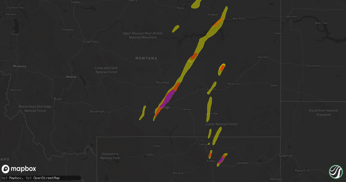
Hail Map on May 21, 2016
Get this storm
May 21 map
$229
one time, instant access
Download today. No call, no setup
Keep the $229
Bought the map and want the full workflow? Apply the entire $229 to a subscription within 7 days. None of it is wasted.
Every map, not just this one
This buys you this map. Subscription and you get every map we run, in the markets you choose from a few cities to whole states to nationwide. Plus real-time alerts the moment a storm fires.
Contact data
Name, contact info, occupancy, even credit band for addresses in the footprint. You go from where it hit to who to call.
Become the source they trust
Unlimited branding weather history reports on demand. You already have the documented answer ready for the property owner, and you are the one who showed up with it.
Property data and RoofTrace estimates
Pull up any address you have got, its value and the exact code rules for that jurisdiction, straight from One Click Code. Then RoofTrace estimates the squares, pitch, and roof value, priced the way you price.
States Impacted by Hail Map on May 21, 2016
Storm reports
North Carolina
| Date | Description |
|---|---|
| 05/21/20166:10 PM CDT | A large tree reported down on the exit ramp of i-77n and west trade st. |
| 05/21/20166:05 PM CDT | 2 trees down near the intersection of hovis rd and south hoskins rd. |
| 05/21/20166:00 PM CDT | Multiple trees down on johnny shaw road |
| 05/21/20163:30 PM CDT | One tree was blown down at lewiston road... Greensboro nc. |
| 05/21/20163:25 PM CDT | Tree down in summerfield. Report from social media. Time estimated. |
| 05/21/20162:55 PM CDT | A local report indicates 1.00 inch wind near EAST BEND |
Georgia
| Date | Description |
|---|---|
| 05/21/20163:00 PM CDT | A tree was blown down across the road near 4904 jeffersonville rd. |
| 05/21/20162:15 PM CDT | A tree was blown down on the 900 block of fortville milledgeville rd. |
Montana
| Date | Description |
|---|---|
| 05/21/20166:49 PM CDT | 64 mph wind gusts record at the jordan airport asos |
| 05/21/20166:30 PM CDT | 70-80 mph wind gust |
| 05/21/20165:30 PM CDT | Quarter sized hail fell between 430pm-500pm |
| 05/21/20165:30 PM CDT | A local report indicates 1.00 inch wind near MELSTONE |
| 05/21/20165:27 PM CDT | Trees down... Including large old trees broken off by the wind. Trailer house off its foundation and owner lost his garage. Large irrigation sprinklers were blown over |
| 05/21/20165:10 PM CDT | Strong winds with the largest hail up to the size of quarters. |
| 05/21/20165:10 PM CDT | Strong winds with the largest hail up to the size of quarters. |
| 05/21/20164:45 PM CDT | A local report indicates 1.00 inch wind near 5 E ROUNDUP |
| 05/21/20164:25 PM CDT | Between golf ball and hen egg. |
| 05/21/20164:25 PM CDT | A local report indicates 1.00 inch wind near BILLINGS |
| 05/21/20164:18 PM CDT | A local report indicates 61 MPH wind near 17 S FORT SMITH |
| 05/21/20164:17 PM CDT | A local report indicates 2.00 inch wind near SHEPHERD |
| 05/21/20164:15 PM CDT | A local report indicates 1.75 inch wind near 6 N BILLINGS |
| 05/21/20164:10 PM CDT | A local report indicates 1.75 inch wind near BILLINGS |
| 05/21/20164:10 PM CDT | A local report indicates 1.75 inch wind near 3 N BILLINGS |
| 05/21/20164:07 PM CDT | A local report indicates 1.75 inch wind near BILLINGS |
| 05/21/20164:07 PM CDT | A local report indicates 1.75 inch wind near BILLINGS |
| 05/21/20164:05 PM CDT | A local report indicates 1.75 inch wind near BILLINGS |
| 05/21/20164:03 PM CDT | A local report indicates 1.75 inch wind near BILLINGS |
| 05/21/20164:01 PM CDT | A local report indicates 1.75 inch wind near 6 W BILLINGS |
| 05/21/20164:00 PM CDT | A local report indicates 66 MPH wind near 3 NW BILLINGS |
| 05/21/20164:00 PM CDT | A local report indicates 2.00 inch wind near 1 N BILLINGS |
| 05/21/20164:00 PM CDT | A local report indicates 2.00 inch wind near 1 N BILLINGS |
| 05/21/20164:00 PM CDT | A local report indicates 1.75 inch wind near BILLINGS |
| 05/21/20164:00 PM CDT | A local report indicates 1.00 inch wind near 6 WNW BILLINGS |
| 05/21/20164:00 PM CDT | Individuals injured by hail. |
| 05/21/20164:00 PM CDT | A local report indicates 1.00 inch wind near 7 W BILLINGS |
| 05/21/20164:00 PM CDT | A local report indicates 1.25 inch wind near BILLINGS |
| 05/21/20164:00 PM CDT | A local report indicates 1.25 inch wind near 4 SW BILLINGS |
| 05/21/20163:59 PM CDT | A local report indicates 1.25 inch wind near 9 SW BILLINGS |
| 05/21/20163:59 PM CDT | A local report indicates 1.25 inch wind near BILLINGS |
| 05/21/20163:55 PM CDT | A local report indicates 2.00 inch wind near BILLINGS |
| 05/21/20163:52 PM CDT | A local report indicates 1.75 inch wind near LAUREL |
| 05/21/20163:51 PM CDT | A local report indicates 1.00 inch wind near LAUREL |
| 05/21/20163:47 PM CDT | A local report indicates 1.00 inch wind near 1 NNE LAUREL |
| 05/21/20163:45 PM CDT | A local report indicates 1.50 inch wind near 2 NE LAUREL |
| 05/21/20163:30 PM CDT | A local report indicates 1.00 inch wind near 1 N JOLIET |
| 05/21/20163:20 PM CDT | A local report indicates 1.00 inch wind near 5 NE COLUMBUS |
| 05/21/20163:05 PM CDT | A local report indicates 1.00 inch wind near 7 W BOYD |
| 05/21/20163:05 PM CDT | A local report indicates 1.00 inch wind near 1 NW COLUMBUS |
| 05/21/20163:05 PM CDT | A local report indicates 60 MPH wind near 7 W BOYD |
| 05/20/20168:44 PM CDT | 83 mph wind gust measured at the bluff creek raws station |
| 05/20/20168:10 PM CDT | 50 to 60 mph wind gust |
| 05/20/20168:07 PM CDT | Quarter sized hail reported by nws employee near signal hill. |
| 05/20/20168:07 PM CDT | Wind gust to 65 mph reported by nws employee. |
| 05/20/20168:05 PM CDT | 83 mph wind gust measured at the bluff creek raws station |
| 05/20/20167:58 PM CDT | 1.5 inch hail estimated near the confluence of the milk and missouri rivers |
| 05/20/20167:50 PM CDT | A local report indicates 1.50 inch wind near ROCK SPRINGS |
| 05/20/20167:45 PM CDT | A local report indicates 1.25 inch wind near 10 SE FRENCHMAN RESERVO |
| 05/20/20167:45 PM CDT | 16 to 20 feet of roof blown off shed. |
| 05/20/20167:45 PM CDT | 80-90 mph estimated wind gust |
| 05/20/20167:38 PM CDT | 60 mph wind gust with nickel sized hail. |
| 05/20/20167:38 PM CDT | Glasgow asos reports 58 mph wind gust. |
| 05/20/20167:35 PM CDT | Tin torn off roof and tree branches down. |
| 05/20/20167:35 PM CDT | 60 mph wind gust... Heavy rain visibility less than 50 feet... And quarter sized hail |
| 05/20/20167:35 PM CDT | A local report indicates 1.00 inch wind near 5 E SACO |
| 05/20/20167:30 PM CDT | Cedar swing set picked up and tipped over. |
| 05/20/20167:24 PM CDT | A local report indicates 1.75 inch wind near 11 N JORDAN |
| 05/20/20167:15 PM CDT | Some quarter sized hail... Most was nickel or pea sized. Also received strong winds during the event |
| 05/20/20167:05 PM CDT | 70 mph estimated wind gust with golf ball sized hail. Windows broken out of west side of ranch home. |
New Mexico
| Date | Description |
|---|---|
| 05/21/20166:19 PM CDT | A local report indicates 1.00 inch wind near PORTALES |
| 05/21/20166:15 PM CDT | A local report indicates 1.00 inch wind near 1 W PORTALES |
| 05/21/20166:14 PM CDT | A local report indicates 1.00 inch wind near 2 W PORTALES |
| 05/20/201611:45 PM CDT | A local report indicates 1.00 inch wind near TUCUMCARI |
| 05/20/20167:46 PM CDT | A local report indicates 1.25 inch wind near 1 W PLEASANT HILL |
| 05/20/20167:25 PM CDT | A local report indicates 1.00 inch wind near 2 E CLOVIS |
Texas
| Date | Description |
|---|---|
| 05/21/20166:53 PM CDT | Thunderstorm wind damage reported at fm 1008 and fm 2331 just west of dayton lakes estates. |
| 05/21/20166:37 PM CDT | A local report indicates 1.00 inch wind near 4 SW HARTLEY |
| 05/21/20166:36 PM CDT | Barn torn up on cr 521 and cr 729 just southeast of sweeney. Possible tornado. |
| 05/21/20166:24 PM CDT | A local report indicates 1.75 inch wind near KERMIT |
| 05/21/20166:17 PM CDT | Quarter size hail reported 9.2 miles west of hartley on fm 998...20 to 30 mph wind...and fair amount of hail but not enough to cover the road. |
| 05/21/20166:15 PM CDT | Metal carport blown over in manvel. |
| 05/21/20166:13 PM CDT | Dime to quarter hail |
| 05/21/20166:00 PM CDT | Trees down in crosby...also marble sized hail. |
| 05/21/20165:57 PM CDT | Reported by the wink asos |
| 05/21/20165:45 PM CDT | Mostly dime to nickel size hail was falling with a few hailstones up to quarter size. |
| 05/21/20165:45 PM CDT | Dime to quarter sized hail at beltway 8 and interstate 10. |
| 05/21/20165:12 PM CDT | Mostly dime to penny size hail was falling with a few ping pong ball size hailstones. |
| 05/21/20164:21 PM CDT | Trees down on road at iowa lane just south of highway 6. |
| 05/20/201610:57 PM CDT | Two inch diameter hail measured with a tape measure. |
| 05/20/201610:54 PM CDT | At least half dollar size hail. Road covered in hail. |
| 05/20/201610:52 PM CDT | Nickel to quarter size hail. |
| 05/20/20169:28 PM CDT | Nickel to quarter size hail measured with a ruler. Hail increased to quarter size since the last report at 925 pm cdt. |
| 05/20/20169:14 PM CDT | Golf ball size hail on the southeast side of dalhart. |
| 05/20/20169:12 PM CDT | Ping pong ball size hail on the south side of dalhart. |
| 05/20/20169:11 PM CDT | Quarter to golf ball size hail. |
| 05/20/20169:10 PM CDT | Hail the size from quarters to golf balls reported at 6th and keeler in dalhart. |
| 05/20/20169:09 PM CDT | A local report indicates 1.00 inch wind near DALHART |
| 05/20/20168:28 PM CDT | Hail has increased to half dollar size since the previous report at this location. Road and yards covered with hail. |
| 05/20/20168:27 PM CDT | Hail has increased to golf ball size since the time of the last report at this same location. |
| 05/20/20168:26 PM CDT | Several hail stones found on the ground that measured 1.75 inches in diameter. Time of event is estimated by radar. |
| 05/20/20168:20 PM CDT | Nickel to quarter size hail. |
| 05/20/20168:20 PM CDT | Dime to quarter size hail. |
| 05/20/20168:20 PM CDT | Severalirrigation pivots overturned. |
| 05/20/20168:17 PM CDT | A local report indicates 2.00 inch wind near 7 S SEAGRAVES |
| 05/20/20168:10 PM CDT | A local report indicates 61 MPH wind near 7 S SEAGRAVES |
| 05/20/20168:07 PM CDT | Power poles down on us 180 |
| 05/20/20168:07 PM CDT | Numerous house and auto windows broken due to hail. |
| 05/20/20168:00 PM CDT | A local report indicates 65 MPH wind near 1 SW SEAGRAVES |
| 05/20/20167:54 PM CDT | Quarter size to tennis ball size hail. |
| 05/20/20167:49 PM CDT | Kbmt relayed public report of one inch hail in saratoga. Video also posted to social media. |
| 05/20/20167:49 PM CDT | 0.95 inch diameter hail measured with calipers. |
| 05/20/20167:47 PM CDT | Ping pong ball to golf ball size hail. |
| 05/20/20167:44 PM CDT | A local report indicates 1.00 inch wind near HARTLEY |
| 05/20/20167:44 PM CDT | A local report indicates 2.00 inch wind near 3 S HARTLEY |
| 05/20/20167:40 PM CDT | A local report indicates 1.75 inch wind near 3 S HARTLEY |
| 05/20/20167:21 PM CDT | Golf ball size hail covering the road in hartley. |
| 05/20/20167:18 PM CDT | A local report indicates 1.50 inch wind near 1 ESE SIMMS |
| 05/20/20167:17 PM CDT | Dime with some quarter size hail. On u.s. 385. |
| 05/20/20167:16 PM CDT | Quarter to ping pong ball size hail. |
| 05/20/20167:11 PM CDT | Ping pong sized hail in jones creek. |
| 05/20/20167:10 PM CDT | A local report indicates 1.50 inch wind near 1 ESE SIMMS |
| 05/20/20167:10 PM CDT | Half dollar to hen egg hail. |
| 05/20/20167:07 PM CDT | Update to the last report of quarters at this location. Hail size is now up to half dollars. |
| 05/20/20167:04 PM CDT | A local report indicates 1.00 inch wind near 4 SW HARTLEY |
Wyoming
| Date | Description |
|---|---|
| 05/21/20166:05 PM CDT | A local report indicates 1.00 inch wind near WYARNO |
| 05/21/20164:19 PM CDT | A local report indicates 58 MPH wind near 15 NW BURGESS JCT |
| 05/20/20169:16 PM CDT | A local report indicates 60 MPH wind near SPOTTED HORSE |
| 05/20/20168:58 PM CDT | Wind knocked over propane tank in yard |
| 05/20/20168:25 PM CDT | A local report indicates 1.50 inch wind near PINE TREE JUNCTION |
| 05/20/20168:11 PM CDT | A trained spotter reported golf ball size hail. |
| 05/20/20168:04 PM CDT | A trained spotter reported golf ball size hail. |
| 05/20/20168:00 PM CDT | A picture of hail up to the size of tennis balls was posted on facebook. |
| 05/20/20167:45 PM CDT | A local report indicates 60 MPH wind near 8 WSW ECHETA |
Washington
| Date | Description |
|---|---|
| 05/21/20166:50 PM CDT | Earlier reports of a funnel cloud and wind damage on saturday 5/21 were the result of an apparent small tornado along 10th ave in kennewick. Video from the public shows |
| 05/21/20166:45 PM CDT | Large tree uprooted on 7th ave and olympia in kennewick. |
Kansas
| Date | Description |
|---|---|
| 05/21/20166:55 PM CDT | A local report indicates 1.00 inch wind near 11 NNW LEOTI |
| 05/21/20166:54 PM CDT | Delayed social media report. Time estimated from radar... Size estimated from picture. |
| 05/21/20166:10 PM CDT | A local report indicates 1.50 inch wind near 7 N SELKIRK |
| 05/21/20166:00 PM CDT | A local report indicates 1.00 inch wind near 7 N SELKIRK |
| 05/20/201611:00 PM CDT | Nickel with some quarter size hail. |
| 05/20/20169:05 PM CDT | A local report indicates 4.25 inch wind near 15 NNW MARIENTHAL |
| 05/20/20168:58 PM CDT | A local report indicates 1.75 inch wind near 15 N LEOTI |
| 05/20/20168:15 PM CDT | Brief tornado |
| 05/20/20168:12 PM CDT | A local report indicates 1.00 inch wind near 13 SW RUSSELL SPRINGS |
| 05/20/20167:15 PM CDT | A local report indicates 2.00 inch wind near 13 N LEOTI |
| 05/20/20167:10 PM CDT | A local report indicates 2.50 inch wind near 11 NNW LEOTI |
| 05/20/20167:09 PM CDT | Brief tornado |
| 05/20/20167:08 PM CDT | Brief tornado |
| 05/20/20167:06 PM CDT | Brief tornado |
| 05/20/20167:06 PM CDT | Brief tornado |
| 05/20/20167:00 PM CDT | A local report indicates 2.00 inch wind near 10 N LEOTI |
Cities Impacted by Hail Map on May 21, 2016
- Winona, KS
- Leoti, KS
- Edson, KS
- Levant, KS
- Colby, KS
- Brewster, KS
- Tribune, KS
- Galena Park, TX
- Houston, TX
- Crosby, TX
- Dayton, TX
- Channelview, TX
- Pasadena, TX
- Brazoria, TX
- Freeport, TX
- Sweeny, TX
- Hull, TX
- Kountze, TX
- Batson, TX
- Liberty, TX
- Sour Lake, TX
- Saratoga, TX
- Boonville, NC
- Dobson, NC
- East Bend, NC
- Lewisville, NC
- Hamptonville, NC
- Jonesville, NC
- Yadkinville, NC
- Malta, MT
- Zortman, MT
- Jordan, MT
- Sand Springs, MT
- Fort Peck, MT
- Nashua, MT
- Brusett, MT
- Cohagen, MT
- Angela, MT
- Saco, MT
- Hinsdale, MT
- Texico, NM
- Conchas Dam, NM
- Tucumcari, NM
- Clovis, NM
- House, NM
- Mcalister, NM
- Portales, NM
- Worden, MT
- Custer, MT
- Laurel, MT
- Edgar, MT
- Billings, MT
- Ingomar, MT
- Joliet, MT
- Shepherd, MT
- Molt, MT
- Bridger, MT
- Musselshell, MT
- Columbus, MT
- Big Timber, MT
- Busby, MT
- Forsyth, MT
- Rosebud, MT
- Sheridan, WY
- Decker, MT
- Birney, MT
- Clearmont, WY
- Dalhart, TX
- Hartley, TX
- Channing, TX
- Hereford, TX
- Bovina, TX
- Friona, TX
- Vega, TX
- Jal, NM
- Kermit, TX
- Seminole, TX
- Andrews, TX
- Seagraves, TX
- Wink, TX
- Hobbs, NM
- Monahans, TX
- Pyote, TX
- Brownfield, TX
- Loop, TX
- Buffalo, WY
- Banner, WY
- Arvada, WY
- Glenrock, WY
- Gillette, WY
- Douglas, WY
- Red Lodge, MT
- Roberts, MT
- Wallace, KS
- Star, NC
- Mosquero, NM
- Siler City, NC
- Pittsboro, NC
- Waller, TX
- Bellville, TX
- Navasota, TX
- Hempstead, TX
- Chappell Hill, TX
- Lame Deer, MT
- Acton, MT
- Park City, MT
- Sanford, NC
- Rogers, NM
- Port Arthur, TX
- Beaumont, TX
- Winnie, TX
- Roundup, MT
- Abbeville, LA
- Vidor, TX
- Rosharon, TX
- Liberty, NC
- Staley, NC
- Hamshire, TX
- Goldthwaite, TX
- Midwest, WY
- Edgerton, WY
- Manvel, TX
- Pearland, TX
- Conyers, GA
- College Station, TX
- Bryan, TX
- Lovington, NM
- Rapelje, MT
- Key Biscayne, FL
- Bay City, TX
- Kaycee, WY
- South Houston, TX
- Wright, WY
- Advance, NC
- Mocksville, NC
- Colstrip, MT
- San Jon, NM
- Alvin, TX
- Liverpool, TX
- Deer Park, TX
- Baytown, TX
- Highlands, TX
- La Porte, TX
- Galliano, LA
- Hialeah, FL
- Miami, FL
- Hillsboro, GA
- Gray, GA
- Tahoka, TX
- Wilson, TX
- Mullin, TX
- Plantersville, TX
- New Ulm, TX
- Cat Spring, TX
- Miami Beach, FL
- Casper, WY
- Stockbridge, GA
- Lithonia, GA
- Damon, TX
- West Columbia, TX
- Bloomington, NE
- Fromberg, MT
- Snow Camp, NC
- Haddock, GA
- Kaplan, LA
- Yoakum, TX
- Charlotte, NC
- Kensington, KS
- Pep, NM