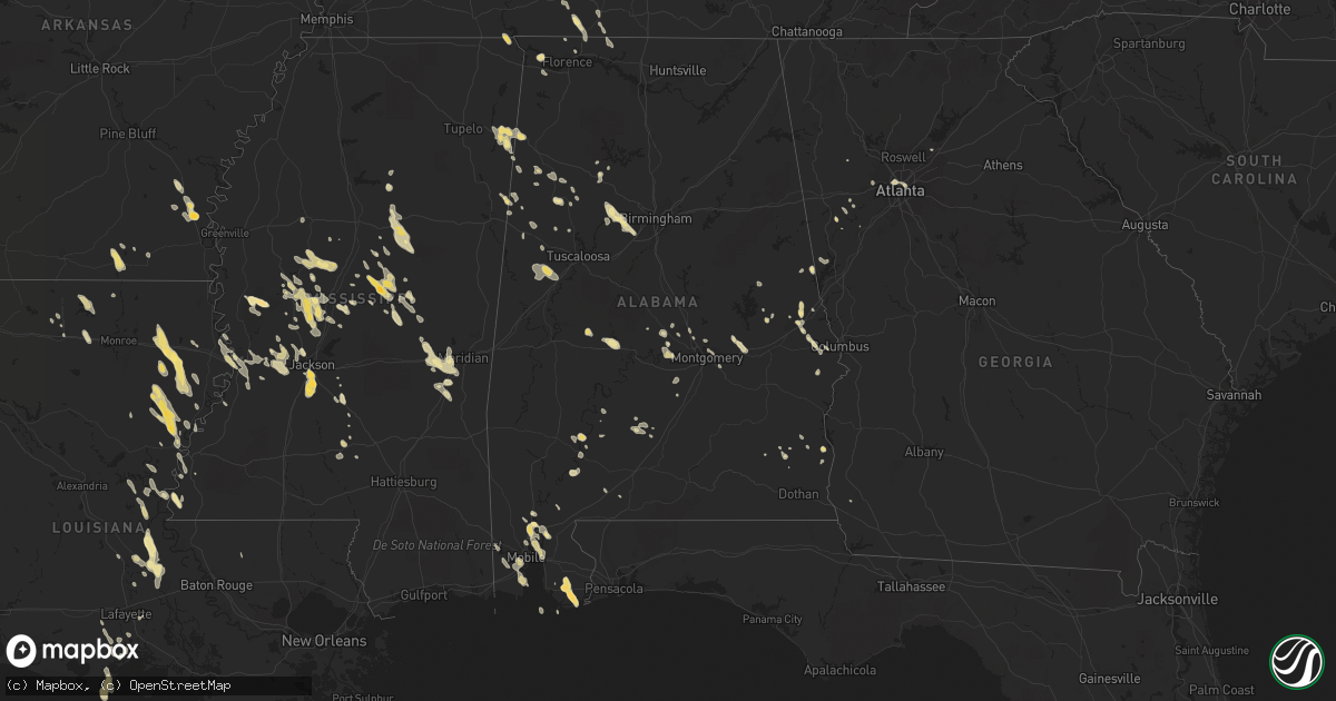
Hail Map in Alabama on May 21, 2012
Get this storm
May 21 map
$229
one time, instant access
Download today. No call, no setup
Keep the $229
Bought the map and want the full workflow? Apply the entire $229 to a subscription within 7 days. None of it is wasted.
Every map, not just this one
This buys you this map. Subscription and you get every map we run, in the markets you choose from a few cities to whole states to nationwide. Plus real-time alerts the moment a storm fires.
Contact data
Name, contact info, occupancy, even credit band for addresses in the footprint. You go from where it hit to who to call.
Become the source they trust
Unlimited branding weather history reports on demand. You already have the documented answer ready for the property owner, and you are the one who showed up with it.
Property data and RoofTrace estimates
Pull up any address you have got, its value and the exact code rules for that jurisdiction, straight from One Click Code. Then RoofTrace estimates the squares, pitch, and roof value, priced the way you price.
Storm reports in Alabama
Alabama
| Date | Description |
|---|---|
| 05/21/20125:45 PM CDT | Tree limbs /not full trees/ were knocked down onto power lines causing power outages. Dime sized hail was also reported at the intersection of cr 68 and cr 36. |
| 05/21/20123:45 PM CDT | A local report indicates 1.00 inch wind near 2 WSW FOWLERS CROSSROAD |
| 05/21/20123:07 PM CDT | Quarter size hail reported at greers market on dauphin island parkway. Lasted about 5 minutes. |
| 05/21/20122:56 PM CDT | A local report indicates 1.00 inch wind near CRAWFORD |
| 05/21/20122:37 PM CDT | Upwards to 25 cent hail. At i85 and sr51. |
| 05/21/20122:30 PM CDT | Quarter size hail reported at west bend. |
| 05/21/20121:02 AM CDT | At hueytown rd and south parkell ave. Trees down along with power lines. |
| 05/21/20121:00 AM CDT | A local report indicates 60 MPH wind near 3 NW HUEYTOWN |
| 05/21/20121:00 AM CDT | A local report indicates 1.00 inch wind near 3 NW HUEYTOWN |
| 05/21/20121:00 AM CDT | Trees reported down in concord. |
| 05/21/20121:00 AM CDT | Tree down in hueytown on walker avenue. |
| 05/21/201212:40 AM CDT | Also several tree limbs of unknown size down. |
| 05/21/201212:40 AM CDT | A local report indicates 1.00 inch wind near 5 W SHORT CREEK |
| 05/21/201212:30 AM CDT | Tree down blocking road at hwy 269 and short drive. |
| 05/21/201212:30 AM CDT | Numerous trees and power lines down along the walker/jefferson county line. |
| 05/20/201211:18 PM CDT | Nickle to quarter size hail was observed roughly 4 miles south of cr 18 along cr 26 or 2 miles south of the fayette county lake. Time estimated from radar. |
| 05/20/201211:13 PM CDT | Along al hwy 5 nw of jasper. Relayed from trained storm spotter. |
| 05/20/201211:10 PM CDT | Quarter size hail reported at the intersection of alabama highway 102 and 13. |
| 05/20/201211:01 PM CDT | Quarter size hail reported at the intersection of county road 49 and 53. |
| 05/20/201211:00 PM CDT | A local report indicates 1.00 inch wind near 2 WSW FOWLERS CROSSROAD |
| 05/20/20127:05 PM CDT | 2 miles east of intersection of us 98 and al 59. This is a relayed report to the ema by citizen. |
All States Impacted by Hail Map on May 21, 2012
Cities Impacted by Hail Map on May 21, 2012
- Miami, NM
- Wilmer, AL
- Tallulah, LA
- Camp Hill, AL
- Foley, AL
- Elberta, AL
- Gulf Shores, AL
- Summerdale, AL
- Orange Beach, AL
- Carthage, MS
- Philadelphia, MS
- Phenix City, AL
- McGehee, AR
- Dermott, AR
- Keystone, NE
- Oakman, AL
- Stewart, MS
- Weir, MS
- Eupora, MS
- Ackerman, MS
- Fort Stockton, TX
- Marathon, TX
- Ripley, OH
- Dover, KY
- Augusta, KY
- Aberdeen, OH
- Maysville, KY
- Manchester, OH
- Georgetown, OH
- Waverly, TN
- Daphne, AL
- Conchas Dam, NM
- Hillsboro, OH
- Hickory, MS
- Chunky, MS
- Hamilton, AL
- Sulligent, AL
- Caledonia, MS
- Steens, MS
- Bay Minette, AL
- Ethel, MS
- Kosciusko, MS
- Jackson, MS
- Shorter, AL
- Tallassee, AL
- Eclectic, AL
- Slade, KY
- Campton, KY
- Rogers, KY
- Moreauville, LA
- Opelika, AL
- Logan, NM
- Jeffersonville, KY
- Mount Sterling, KY
- Mount Vernon, AL
- Dell City, TX
- Terry, MS
- Florence, MS
- Edwards, MS
- Westville, FL
- Caryville, FL
- Bonifay, FL
- Ponce De Leon, FL
- Enterprise, MS
- Bolton, MS
- Baldwin, ND
- Driscoll, ND
- Regan, ND
- Sterling, ND
- Vaughan, MS
- Bentonia, MS
- Yazoo City, MS
- Benton, MS
- Canton, MS
- Clovis, NM
- Grady, NM
- Adrian, TX
- Crossett, AR
- Mobile, AL
- Theodore, AL
- Utica, MS
- Trenton, KY
- Pembroke, KY
- Elkton, KY
- Marion, AL
- Marion Junction, AL
- Miracle, KY
- Vinton, VA
- Hamburg, AR
- Ashby, NE
- Tremont, MS
- Smithville, MS
- Fulton, MS
- Vicksburg, MS
- Eutaw, AL
- Knoxville, AL
- Ralph, AL
- Camden, MS
- Winnsboro, LA
- Wisner, LA
- Gilbert, LA
- Pickens, MS
- Carrollton, GA
- Decatur, MS
- Union, MS
- Sabina, OH
- New Vienna, OH
- Leesburg, OH
- Raton, NM
- Whatley, AL
- Folsom, NM
- Suwanee, GA
- Buford, GA
- Cumberland City, TN
- Erin, TN
- Uniontown, AL
- Newbern, AL
- Dalhart, TX
- Hermitage, AR
- Billingsley, AL
- Berry, AL
- Woodville, MS
- Hopkinsville, KY
- Prattville, AL
- Irvine, KY
- Ravenna, KY
- Vega, TX
- Franklin, AL
- Lower Peach Tree, AL
- Tucumcari, NM
- Monterey, LA
- Gainestown, AL
- Florence, AL
- Cherokee, AL
- Lafayette, AL
- Nara Visa, NM
- Brasstown, NC
- Center, ND
- Siler, KY
- Barbourville, KY
- Williamsburg, KY
- Satsuma, AL
- Creola, AL
- Saraland, AL
- Axis, AL
- Salem, AL
- Richlands, NC
- Uriah, AL
- Steele, ND
- Wilton, ND
- West Union, OH
- Simmesport, LA
- Plaucheville, LA
- Melville, LA
- Palmetto, LA
- Batchelor, LA
- Cloudcroft, NM
- Friona, TX
- Camden, AL
- Lawrenceburg, TN
- Leoma, TN
- Fort Davis, TX
- Farmerville, LA
- Mendenhall, MS
- Braxton, MS
- Lexington, MS
- Iron City, TN
- Westpoint, TN
- Ariton, AL
- McCool, MS
- Abbeville, AL
- Shorterville, AL
- Trementina, NM
- Garita, NM
- Five Points, AL
- Abbeville, LA
- Georgiana, AL
- Vidalia, LA
- Natchez, MS
- Gordo, AL
- Parrish, AL
- Quinton, AL
- Adger, AL
- Bessemer, AL
- McEwen, TN
- Baskin, LA
- Krotz Springs, LA
- Fordoche, LA
- Sicily Island, LA
- Arthur, NE
- Clayton, LA
- Cruger, MS
- Tchula, MS
- Durant, MS
- Belzoni, MS
- Ogallala, NE
- Coila, MS
- Vaughn, NM
- McKee, KY
- Holly Bluff, MS
- Hereford, TX
- Detroit, AL
- Chambers, NE
- Rayville, LA
- Delhi, LA
- Newellton, LA
- Washington, LA
- Tillar, AR
- Lake Village, AR
- Iuka, MS
- Prentiss, MS
- Wallace, NE
- Lemoyne, NE
- Lewellen, NE
- Elsie, NE
- Madrid, NE
- Paxton, NE
- Clinton, LA
- Sedan, NM
- Northport, AL
- Rolling Fork, MS
- Fort Campbell, KY
- Oak Grove, KY
- Ethridge, TN
- Dimmitt, TX
- Ferriday, LA
- Fayette, AL
- Maynardville, TN
- Washburn, TN
- Powder Springs, TN
- Grand Bay, AL
- Coosada, AL
- Elmore, AL
- Saint Martinville, LA
- Flemingsburg, KY
- Hillsboro, KY
- Owingsville, KY
- Atlanta, GA
- Coldiron, KY
- Bledsoe, KY
- Livingston, TX
- Roy, NM
- Marksville, LA
- Walnut Grove, MS
- Dallas, GA
- Dawson, ND
- Braddock, ND
- Calhoun City, MS
- San Jon, NM
- Bard, NM
- Stewart, TN
- Broadview, NM
- Amherst, TX
- Hayneville, AL
- Letohatchee, AL
- Raymond, MS
- Kilmichael, MS
- Corona, NM
- Stanton, KY
- Pachuta, MS
- Rose Hill, MS
- Johnson, KS
- Beattyville, KY
- Mayslick, KY
- Seale, AL
- Autaugaville, AL
- Wewahitchka, FL
- Saint Joseph, TN
- Killen, AL
- Lexington, AL
- Sharpsburg, KY
- Las Vegas, NM
- Marion, LA
- Weaverville, NC
- Magee, MS
- Jasper, AL
- Lynchburg, OH
- Edison, OH
- Caledonia, OH
- Galion, OH
- Skipperville, AL
- Ozark, AL
- Santa Rosa, NM
- Montgomery, AL
- Pike Road, AL
- Hardy, VA
- Sextons Creek, KY
- Booneville, KY
- Hamilton, MS
- Millport, AL
- Means, KY
- Frenchburg, KY
- Greenwood Springs, MS
- Herndon, KY
- Waterproof, LA
- Vina, AL
- Clarkdale, GA
- Lithia Springs, GA
- Powder Springs, GA
- Austell, GA
- Douglasville, GA
- Winston, GA
- Sondheimer, LA
- Erath, LA
- Amarillo, TX
- Vernon, AL
- Reform, AL
- Madison, MS
- Kountze, TX
- Kim, CO
- Rayne, LA
- Vernon, FL
- Chipley, FL
- Summertown, TN
- Oak Ridge, LA
- Nauvoo, AL
- Pine Apple, AL
- Newkirk, NM
- Lowndesboro, AL
- Silver Creek, MS
- Dubach, LA
- Saint Joseph, LA
- Fort Necessity, LA
- Helena, OH
- Newnan, GA
- Deatsville, AL
- Barnardsville, NC
- Alexander, NC
- French Camp, MS
- Waynesboro, TN
- Greenwell Springs, LA
- Flora, MS
- Silver City, MS
- Pittsview, AL
- Centerville, TN
- Clay City, KY
- Bankston, AL
- McDavid, FL
- Century, FL
- Chunchula, AL
- Townley, AL
- Carrollton, AL
- Amistad, NM
- Meridian, MS
- Bassfield, MS
- Stockton, AL
- Cimarron, NM
- Eldridge, AL
- Frisco City, AL
- Farwell, TX
- Bovina, TX
- Byram, MS
- Sardinia, OH
- Pickens, AR
- Louisville, MS
- Pineville, KY
- Sallis, MS
- New Castle, VA
- New Iberia, LA
- Youngsville, LA
- Clinton, MS
- Guin, AL
- Beaverton, AL
- Crystal Springs, MS
- Richland, MS
- Clopton, AL
- Brandon, MS
- Clarksville, TN
- Whitesburg, GA
- Forest Home, AL
- Jonesville, LA
- Greenwood, MS
- Itta Bena, MS
- Mount Pleasant, TN
- Selma, AL
- Calhoun, LA
- Choudrant, LA
- Vredenburgh, AL
- Island, KY
- Sacramento, KY
- Lottie, LA
- Kilgore, NE
- Nenzel, NE
- Cody, NE
- Crookston, NE
- Saint Francis, SD
- Roanoke, AL
- Donalsonville, GA
- Sharps Chapel, TN
- Speedwell, TN
- Loretto, TN
- Five Points, TN
- Harrisonburg, LA
- Pensacola, FL
- Coden, AL
- Quitman, MS
- Springer, NM
- Newton, MS
- Acme, LA
- Big Creek, MS
- Dadeville, AL
- Vincent, KY
- Lorman, MS
- Collinsville, MS
- Little Rock, MS
- Counce, TN
- Brewton, AL
- Winchester, KY
- Winfield, AL
- Port Gibson, MS
- Valley, AL
- Plantersville, AL
- Morganza, LA
- Port Barre, LA
- Lettsworth, LA
- Kaplan, LA
- Daviston, AL
- Alexander City, AL
- Lagrange, GA
- Franklin, GA
- Kennedy, AL
- Elrod, AL
- Mescalero, NM
- Ruidoso, NM
- Ruidoso Downs, NM
- Chappell, KY
- Pine Ridge, KY
- Tyner, KY
- Winchester, AR
- Ruston, LA
- Hamptonville, NC
- Yadkinville, NC
- Carbon Hill, AL
- Stoney Fork, KY
- West, MS
- Wagon Mound, NM
- Arnaudville, LA
- Ewing, KY
- Clayton, AL
- Villa Rica, GA
- Rogersville, AL
- Anderson, AL
- Midland City, AL


