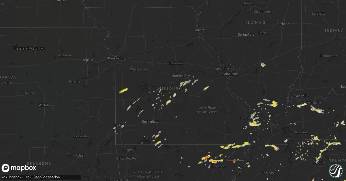
Hail Map in Missouri on May 20, 2018
Get this storm
May 20 map
$229
one time, instant access
Download today. No call, no setup
Keep the $229
Bought the map and want the full workflow? Apply the entire $229 to a subscription within 7 days. None of it is wasted.
Every map, not just this one
This buys you this map. Subscription and you get every map we run, in the markets you choose from a few cities to whole states to nationwide. Plus real-time alerts the moment a storm fires.
Contact data
Name, contact info, occupancy, even credit band for addresses in the footprint. You go from where it hit to who to call.
Become the source they trust
Unlimited branding weather history reports on demand. You already have the documented answer ready for the property owner, and you are the one who showed up with it.
Property data and RoofTrace estimates
Pull up any address you have got, its value and the exact code rules for that jurisdiction, straight from One Click Code. Then RoofTrace estimates the squares, pitch, and roof value, priced the way you price.
Storm reports in Missouri
Missouri
| Date | Description |
|---|---|
| 05/20/20186:45 PM CDT | A large hardwood tree was uprooted. Picture via social media. Delayed report... Time estimated by radar. |
| 05/20/20186:45 PM CDT | Social media pictures of trees uprooted. |
| 05/20/20186:40 PM CDT | Large tree limb down in bradleyville. |
| 05/20/20186:35 PM CDT | Corrects previous tstm wnd dmg report from 1 wsw climax springs. A large hardwood tree was uprooted. Picture via social media. Delayed report... Time estimated by radar |
| 05/20/20183:25 PM CDT | Quarter size hail reported. |
| 05/20/20183:25 PM CDT | Trees damaged with storms. |
| 05/20/20189:27 AM CDT | Hail between pea and quarter size fell in pershing. |
| 05/20/20188:00 AM CDT | Three commercial structures with significant sign damage. Roof damage reported at several locations including the mall. Seven or eight homes with shingle damage. Two ho |
| 05/20/20187:47 AM CDT | At 1246 AM CDT, a severe thunderstorm was located 10 miles north of Milan, moving east at 40 mph. HAZARD...Ping pong ball size hail and 60 mph wind gusts. SOURCE...Radar indicated. IMPACT...People and animals outdoors will be injured. Expect hail damage to roofs, siding, windows, and vehicles. Expect wind damage to roofs, siding, and trees. Locations impacted include... Kirksville, Unionville, Lancaster, Green City, Queen City, Novinger, Greentop, Downing, Greencastle, Glenwood, Pollock, Worthington, Livonia, Lemons and Green Castle. |
| 05/20/20187:15 AM CDT | Reported by off duty missouri dept of conservation employee. |
| 05/20/20184:44 AM CDT | At 944 AM CDT, severe thunderstorms were located along a line extending from near Swiss to 8 miles south of Rosebud, moving northeast at 35 mph. HAZARD...60 mph wind gusts and quarter size hail. SOURCE...Trained weather spotters. IMPACT...Hail damage to vehicles is expected. Expect wind damage to roofs, siding, and trees. Locations impacted include... Sullivan, Owensville, Hermann, New Haven, Gerald, Bland, Rosebud, Miramiguoa Park, Beaufort, Swiss, Treloar, Mount Sterling, Drake, Gasconade, Berger, Leslie, Canaan, Noser Mill, Japan and Stanton.This includes Interstate 44 in Missouri between exits 225 and 230. This also includes Deutschheim Historic Site and Meramec State Park. |
| 05/20/20184:36 AM CDT | At 936 PM CDT, severe thunderstorms were located along a line extending from 6 miles north of St. James to near Salem, moving northeast at 65 mph. HAZARD...60 mph wind gusts and penny size hail. SOURCE...Radar indicated. IMPACT...Expect damage to roofs, siding, and trees. Locations impacted include... Washington, Union, Sullivan, St. Clair, Cuba, Steelville, Bourbon, Anthonies Mill, Gerald, Viburnum, Parkway, Leasburg, Miramiguoa Park, Cherryville, Courtois, Beaufort, Leslie, St. Cloud, Stanton and Shirley.This includes Interstate 44 in Missouri between exits 203 and 242. This also includes Onondaga Cave State Park, Dillard Mill HistoricSite, and Meramec State Park. |
| 05/20/20184:23 AM CDT | At 923 AM CDT, a severe thunderstorm was located near Belle, moving east at 40 mph. HAZARD...60 mph wind gusts and quarter size hail. SOURCE...Radar indicated. IMPACT...Hail damage to vehicles is expected. Expect wind damage to roofs, siding, and trees. Locations impacted include... Bland, Canaan and Oak Hill. |
| 05/20/20184:13 AM CDT | At 913 AM CDT, a severe thunderstorm was located near Vienna, or 14 miles north of Rolla, moving east at 30 mph. HAZARD...60 mph wind gusts and quarter size hail. SOURCE...Radar indicated. IMPACT...Hail damage to vehicles is expected. Expect wind damage to roofs, siding, and trees. Locations impacted include... Belle... Vienna... Vichy... Rosati...This includes Interstate 44 between mile markers 198 and 200. |
| 05/20/20184:05 AM CDT | At 905 AM CDT, a severe thunderstorm was located near Rich Fountain, moving east at 45 mph. HAZARD...60 mph wind gusts and quarter size hail. SOURCE...Radar indicated. IMPACT...Hail damage to vehicles is expected. Expect wind damage to roofs, siding, and trees. Locations impacted include... Owensville, Linn, Belle, Bland, Freeburg, Rosebud, Westphalia, Rich Fountain, Swiss, Mount Sterling, Drake, Meta, Argyle, Canaan, Koeltztown, Bay and Loose Creek. |
| 05/20/20183:56 AM CDT | At 856 PM CDT, severe thunderstorms were located along a line extending from near Westphalia to near Rich Fountain to near Belle, moving northeast at 30 mph. HAZARD...60 mph wind gusts. SOURCE...Radar indicated. IMPACT...Expect damage to roofs, siding, and trees. Locations impacted include... Owensville, Linn, Rosebud, Chamois, Swiss, Mount Sterling, Drake, Gasconade, Morrison, Canaan, Frankenstein, Bay, Loose Creek and Bonnots Mill. |
| 05/20/20183:49 AM CDT | At 849 PM CDT, severe thunderstorms were located along a line extending from Fort Leonard Wood to 11 miles west of Licking to 6 miles north of Houston to 6 miles northeast of Cabool, moving northeast at 35 mph. HAZARD...60 mph wind gusts. SOURCE...Radar indicated. IMPACT...Expect damage to roofs, siding, and trees. Locations impacted include... Rolla... Fort Leonard Wood... Montauk State Park... Salem... St. James... Licking... Houston... Doolittle... Newburg... Raymondville... Edgar Springs... Lenox... Montauk... Jadwin... Beulah... Lake Spring... Success... Anutt... Bangert... Roby...This includes Interstate 44 between mile markers 179 and 200. |
| 05/20/20183:24 AM CDT | At 824 PM CDT, severe thunderstorms were located along a line extending from 6 miles south of St. Thomas to near Freeburg to 8 miles south of Vienna, moving east at 40 mph. HAZARD...60 mph wind gusts. SOURCE...Radar indicated. IMPACT...Expect damage to roofs, siding, and trees. Locations impacted include... Cuba, Owensville, Belle, Bland, Freeburg, Rosebud, Westphalia, Rich Fountain, Meta, Argyle, Canaan, Koeltztown and Oak Hill.This includes Interstate 44 in Missouri between exits 203 and 210. |
| 05/20/20182:57 AM CDT | At 756 PM CDT, severe thunderstorms were located along a line extending from 6 miles southeast of Rocheport to near Jamestown, moving northeast at 35 mph. HAZARD...60 mph wind gusts. SOURCE...Radar indicated. This storm has previously produced wind damage in Moniteau County. IMPACT...Expect damage to roofs, siding, and trees. Locations impacted include... Columbia, Ashland, Columbia Regional Airport, Jamestown, Easley, Murry, Lupus, McBaine, Kliever, Carrington, Sandy Hook and Wilton.This includes Interstate 70 in Missouri between exits 124 and 137. This also includes Rock Bridge State Park and Jewell CemeteryHistoric Site. |
| 05/20/20182:40 AM CDT | At 739 PM CDT, severe thunderstorms were located along a line extending from 8 miles southeast of Eldon to near Iberia to near Richland, moving northeast at 30 mph. HAZARD...60 mph wind gusts and penny size hail. SOURCE...Radar indicated. IMPACT...Expect damage to roofs, siding, and trees. Locations impacted include... Richland... Dixon... Belle... Crocker... Iberia... Vienna... Saint Elizabeth... St. Elizabeth... Tuscumbia... Eugene... Brinktown... Ulman... Vichy... Swedeborg... Marys Home... Ozark Springs...This includes Interstate 44 between mile markers 145 and 147. |
| 05/20/20182:35 AM CDT | At 735 PM CDT, a severe thunderstorm was located over Lead Hill, or 14 miles northeast of Harrison, moving northeast at 20 mph. HAZARD...60 mph wind gusts and quarter size hail. SOURCE...Radar indicated. IMPACT...Hail damage to vehicles is expected. Expect wind damage to roofs, siding, and trees. Locations impacted include... Diamond City... Lead Hill... Willis... Winington... Price Place... Ozark Isle... South Lead Hill... Peel... Oakland... Monarch... Bull Shoals Lake... |
| 05/20/20182:23 AM CDT | At 723 PM CDT, severe thunderstorms were located along a line extending from 7 miles south of Pilot Grove to near Bunceton to Tipton, moving northeast at 40 mph. HAZARD...60 mph wind gusts and penny size hail. SOURCE...Radar indicated. IMPACT...Expect damage to roofs, siding, and trees. Severe thunderstorms will be near... Boonville around 745 PM CDT.Other locations impacted by these severe thunderstorms includePrairie Home and Wooldridge.This includes Interstate 70 in Missouri between mile markers 103 and114. |
| 05/20/20182:13 AM CDT | At 711 PM CDT, severe thunderstorms were located along a line extending from near Otterville to near Versailles, moving northeast at 40 mph. HAZARD...60 mph wind gusts. SOURCE...Radar indicated. IMPACT...Expect damage to roofs, siding, and trees. Locations impacted include... California, Tipton, Jamestown, Clarksburg, High Point, McGirk, Lupus, Kliever, Sandy Hook, Latham and Enon. |
| 05/20/20182:06 AM CDT | At 706 PM CDT, severe thunderstorms were located along a line extending from 7 miles southwest of Seymour to 7 miles southwest of Mansfield to near Ava, moving northeast at 25 mph. HAZARD...60 mph wind gusts. SOURCE...Radar indicated. IMPACT...Expect damage to roofs, siding, and trees. Locations impacted include... Mountain Grove... Seymour... Mansfield... Dawson... Norwood... Hartville... Odin... |
| 05/20/20181:43 AM CDT | At 643 PM CDT, a severe thunderstorm was located near Diamond City, or 13 miles southeast of Forsyth, moving northeast at 35 mph. HAZARD...60 mph wind gusts and quarter size hail. SOURCE...Radar indicated. IMPACT...Hail damage to vehicles is expected. Expect wind damage to roofs, siding, and trees. Locations impacted include... Bull Shoals Lake... Wasola... Protem... Thornfield... Rueter... Noble... Rockbridge... Long Run... |
| 05/20/20181:19 AM CDT | At 619 PM CDT, a severe thunderstorm was located over Taneyville, or 7 miles northeast of Forsyth, moving northeast at 35 mph. HAZARD...60 mph wind gusts and quarter size hail. SOURCE...Radar indicated. IMPACT...Hail damage to vehicles is expected. Expect wind damage to roofs, siding, and trees. Locations impacted include... Ava... Taneyville... Garrison... Rome... Brownbranch... Bradleyville... Elkhead... Goodhope... Keltner... Dogwood... |
| 05/20/20181:16 AM CDT | At 615 AM CDT, a severe thunderstorm was located over Wood River, moving east at 25 mph. HAZARD...60 mph wind gusts and quarter size hail. SOURCE...Trained weather spotters. IMPACT...Hail damage to vehicles is expected. Expect wind damage to roofs, siding, and trees. Locations impacted include... Granite City, Alton, Edwardsville, Godfrey, Glen Carbon, Wood River, Highland, Bethalto, Staunton, East Alton, South Roxana, Roxana, Hartford, Worden, Marine, Livingston, Alhambra, West Alton, Prairietown and Dorsey.This includes Interstate 55 in Illinois between exits 23 and 41. |
| 05/20/20181:08 AM CDT | At 608 PM CDT, a severe thunderstorm was located 10 miles south of Warsaw, moving northeast at 35 mph. HAZARD...60 mph wind gusts and nickel size hail. SOURCE...Radar indicated. IMPACT...Expect damage to roofs, siding, and trees. Locations impacted include... Truman Lake... Truman State Park... Warsaw... Lincoln... Cole Camp... Lakeview Heights... Crockerville... Zora... Fristoe... Knobby... Edmonson... Mora... Edwards... Hastain... Whitakerville... |
| 05/19/201811:58 PM CDT | At 457 PM CDT, a severe thunderstorm was located near Rich Hill, moving northeast at 25 mph. HAZARD...Half dollar size hail. SOURCE...Radar indicated. IMPACT...Damage to vehicles is expected. This severe thunderstorm will remain over mainly rural areas of southeastern Bates County. |
| 05/19/201811:54 PM CDT | At 453 PM CDT, a severe thunderstorm was located 12 miles west of Stockton, moving northeast at 35 mph. HAZARD...60 mph wind gusts and quarter size hail. SOURCE...Radar indicated. IMPACT...Hail damage to vehicles is expected. Expect wind damage to roofs, siding, and trees. Locations impacted include... El Dorado Springs... Jerico Springs... Filley... Wagoner... Olympia... Cedar Springs... |
| 05/19/201811:35 PM CDT | At 434 PM CDT, a severe thunderstorm was located over Rich Hill, moving northeast at 20 mph. HAZARD...Quarter size hail. SOURCE...Radar indicated. IMPACT...Damage to vehicles is expected. This severe thunderstorm will be near... Rich Hill around 440 PM CDT. Butler around 500 PM CDT. |
| 05/19/201810:47 PM CDT | At 347 PM CDT, a severe thunderstorm was located over Arbyrd, or 8 miles southwest of Senath, moving northeast at 20 mph. HAZARD...60 mph wind gusts and quarter size hail. SOURCE...Radar indicated. IMPACT...Hail damage to vehicles is expected. Expect wind damage to roofs, siding, and trees. Locations impacted include... Blytheville, Gosnell, Manila, Lake City, Leachville, Senath, Monette, Cardwell, Hornersville, Arbyrd, Black Oak, Jolliff Store, Delfore, Calumet, Carmi, Whisp, Buckeye, Lester, Mounds and Arkmo. |
| 05/19/20189:45 PM CDT | At 245 PM CDT, a severe thunderstorm was located near Marmaduke, moving east at 10 mph. HAZARD...Golf ball size hail and 60 mph wind gusts. SOURCE...Radar indicated. IMPACT...People and animals outdoors will be injured. Expect hail damage to roofs, siding, windows, and vehicles. Expect wind damage to roofs, siding, and trees. Locations impacted include... Paragould, Kennett, Rector, Senath, Marmaduke, Oak Grove Heights, Cardwell, Hornersville, Arbyrd, Greenway, Nimmons, Mounds, Halliday, Arkmo, West Kennett, Leonard, Bell City, Pratt, Noland and Bertig. |
| 05/19/20189:45 PM CDT | At 244 PM CDT, a severe thunderstorm was located over Clarkton, or 7 miles east of Campbell, moving east at 25 mph. HAZARD...60 mph wind gusts and half dollar size hail. SOURCE...Radar indicated. IMPACT...Hail damage to vehicles is expected. Expect wind damage to roofs, siding, and trees. Locations impacted include... Portageville, Gideon, Parma, Risco, Tallapoosa and Catron. |
| 05/19/20188:13 PM CDT | A local report indicates 66 MPH wind near 1 S COLUMBIA |
| 05/19/20188:00 PM CDT | Thunderstorm winds downed a tree on state highway t. |
| 05/19/20187:35 PM CDT | Tractor trailer blown over on west bound exit ramp on highway 60 at mansfield and hartville exit. |
| 05/19/20187:25 PM CDT | Numerous tree limbs and a couple of trees blown down around town. |
| 05/19/20187:10 PM CDT | Social media pictures of quarter size hail. |
All States Impacted by Hail Map on May 20, 2018
Cities Impacted by Hail Map on May 20, 2018
- Altamont, TN
- Pelham, TN
- Hillsboro, TN
- Cave City, KY
- Savannah, TN
- Lutts, TN
- Harrisburg, IL
- Galatia, IL
- Grove Hill, AL
- Jackson, AL
- Laurel Hill, FL
- Black Rock, AR
- Pocahontas, AR
- Powhatan, AR
- Smithville, AR
- Portia, AR
- Walnut Ridge, AR
- Middletown, OH
- Spring, TX
- Tomball, TX
- Conroe, TX
- Olmstead, KY
- Allensville, KY
- Adairville, KY
- Jackson, MS
- Flora, MS
- Utica, MS
- Freeport, FL
- Morganfield, KY
- Brackettville, TX
- Laredo, TX
- Hebbronville, TX
- Baxter Springs, KS
- Galena, KS
- Columbus, KS
- Riverton, KS
- Millport, AL
- Clarksdale, MS
- Scottsville, VA
- Charlottesville, VA
- Palmyra, VA
- Quapaw, OK
- Greenfield, TN
- Westmoreland, TN
- Hartsville, TN
- Lafayette, TN
- Augusta, AR
- Van Horn, TX
- Corning, AR
- Piggott, AR
- Hartford, KY
- Diamond, MO
- Hanover, IN
- Lexington, IN
- Madison, IN
- Oran, MO
- Benton, MO
- Sikeston, MO
- Clanton, AL
- Sylacauga, AL
- Sturgis, KY
- Adams, TN
- Clarksville, TN
- Pollard, AR
- Dongola, IL
- Anna, IL
- Granite Falls, NC
- Dunlap, TN
- Martin, TN
- Cottage Grove, TN
- Paris, TN
- Dukedom, TN
- South Fulton, TN
- Puryear, TN
- Palmersville, TN
- Twin Falls, ID
- Golconda, IL
- Grantsburg, IL
- Lake Cormorant, MS
- Brevard, NC
- Cedar Mountain, NC
- Crocker, MO
- Iberia, MO
- Richland, MO
- Monroe, OH
- Atmore, AL
- Carthage, TX
- Long Branch, TX
- Lenoir, NC
- Hudson, NC
- Olivehill, TN
- Lexa, AR
- Goodwater, AL
- Henderson, KY
- Owensboro, KY
- Robards, KY
- Cobden, IL
- Alto Pass, IL
- Belmont, MS
- Red Bay, AL
- Vina, AL
- Golden, MS
- Tuscaloosa, AL
- Cottondale, AL
- Sabinal, TX
- Gallatin, TN
- Vienna, MO
- Dixon, MO
- Como, MS
- Tutwiler, MS
- Alligator, MS
- Duncan, MS
- Drew, MS
- Steelville, MO
- Bolivar, TN
- Ashland, MS
- Walnut, MS
- Falkner, MS
- Bertrand, MO
- East Prairie, MO
- Cash, AR
- Swifton, AR
- Shobonier, IL
- Vandalia, IL
- Brownstown, IL
- Saint Peter, IL
- Portland, TN
- Uvalde, TX
- Carrier Mills, IL
- Marion, IL
- Eldorado, IL
- Raleigh, IL
- Stonefort, IL
- Knobel, AR
- Dickson, TN
- Batesville, AR
- Hanceville, AL
- Hayden, AL
- Blue Mountain, MS
- Faunsdale, AL
- Newbern, AL
- Ripley, TN
- Talladega, AL
- Holly Springs, MS
- Jonesboro, AR
- Alicia, AR
- Hoxie, AR
- Paragould, AR
- Bono, AR
- Yazoo City, MS
- Camden, OH
- Bell City, MO
- Taneyville, MO
- Bradleyville, MO
- Gattman, MS
- Caledonia, MS
- Eaton, OH
- Climax Springs, MO
- Camdenton, MO
- Gravois Mills, MO
- Roach, MO
- Higginson, AR
- Searcy, AR
- Hendersonville, TN
- Bethpage, TN
- Brandon, MS
- Ellijay, GA
- Sharpsburg, GA
- Newnan, GA
- Sulphur Rock, AR
- Strawberry, AR
- Galena, MO
- Cape Fair, MO
- Marianna, AR
- Lebanon, MO
- Stoutland, MO
- Aubrey, AR
- Gideon, MO
- Holcomb, MO
- Campbell, MO
- Clarkton, MO
- Groveton, TX
- Moscow, TN
- Tamms, IL
- Atlanta, GA
- Cruger, MS
- Tchula, MS
- Cairo, IL
- Miller City, IL
- Thebes, IL
- Scott City, MO
- Stockton, MO
- Inverness, MS
- Vienna, IL
- Simpson, IL
- Greenville, SC
- Bedias, TX
- Iola, TX
- Lincolnton, GA
- Rich Hill, MO
- Butler, MO
- Enterprise, MS
- Arlington, TN
- Millington, TN
- Memphis, TN
- Oakland, KY
- Smiths Grove, KY
- Theodosia, MO
- Lineville, AL
- Delta, AL
- Wedowee, AL
- Valentine, TX
- Whites Creek, TN
- Joelton, TN
- Whitsett, TX
- Adolphus, KY
- Scottsville, KY
- Kirbyville, MO
- Powersite, MO
- Hollister, MO
- Chickamauga, GA
- Bessemer, AL
- Miami, OK
- Fairland, OK
- Cross Plains, TN
- Orlinda, TN
- D Hanis, TX
- Freeburg, MO
- Argyle, MO
- Somerville, TN
- Elkton, KY
- Guthrie, KY
- Beaver Dam, KY
- Nashville, TN
- Sullivan, MO
- Bourbon, MO
- Old Hickory, TN
- Goodlettsville, TN
- Madison, TN
- Falls City, TX
- Cotulla, TX
- Fowlerton, TX
- Tilden, TX
- Olaton, KY
- Luxora, AR
- Medon, TN
- Pinson, TN
- Mound City, IL
- Linn, MO
- Jourdanton, TX
- Hickory Valley, TN
- Portageville, MO
- Marston, MO
- Mounds, IL
- Calhoun, KY
- Horse Branch, KY
- Utica, KY
- Livermore, KY
- Dundee, KY
- Oxford, MS
- Etta, MS
- Thaxton, MS
- Bald Knob, AR
- Seneca, MO
- Neosho, MO
- Stewart, TN
- Magnolia, KY
- Tullahoma, TN
- Lynchburg, TN
- Vernon, AL
- Sarah, MS
- Dundee, MS
- Crenshaw, MS
- New Market, AL
- Butler, AL
- Shell Knob, MO
- Golden, MO
- Cave City, AR
- Watson, AR
- Tillar, AR
- Ozark, AL
- Porter, TX
- Leitchfield, KY
- Joplin, MO
- Oldfield, MO
- Ava, MO
- Chadwick, MO
- Boomer, NC
- Dayton, TN
- Petersburg, TN
- Fayetteville, TN
- Realitos, TX
- Rocksprings, TX
- Del Rio, TX
- Red Level, AL
- Newbern, TN
- Hickman, KY
- Springfield, TN
- Bradford, TN
- Rutherford, TN
- Shaw, MS
- Boyle, MS
- Graff, MO
- Mountain Grove, MO
- Cumberland City, TN
- Vanleer, TN
- Cumberland Furnace, TN
- Belfast, TN
- Satartia, MS
- Castalian Springs, TN
- Pearsall, TX
- Lilbourn, MO
- New Madrid, MO
- Carthage, MO
- Blytheville, AR
- Abbeville, MS
- Westport, TN
- Huntingdon, TN
- Jackson, TN
- Vicksburg, MS
- Eglin Afb, FL
- Tenaha, TX
- McEwen, TN
- Henderson, TN
- Jerico Springs, MO
- Sheldon, MO
- Lamar, MO
- Centerville, IN
- Fairmont, NC
- Beaverton, AL
- Camden, MS
- Beech Grove, AR
- Park City, KY
- Owensville, MO
- Bland, MO
- Three Rivers, TX
- Rueter, MO
- Cedarcreek, MO
- Idaho Falls, ID
- Bowling Green, KY
- Wyandotte, OK
- Rocky Hill, KY
- Sidon, MS
- Nacogdoches, TX
- Newport, AR
- Vinita, OK
- West Helena, AR
- Horse Cave, KY
- Panama City, FL
- Edwards, MS
- Tremont, MS
- Fulton, MS
- Dadeville, MO
- Aldrich, MO
- Walnut Grove, MO
- White House, TN
- Cottontown, TN
- Quinton, AL
- Mulga, AL
- Brookland, AR
- Lynnville, TN
- Pulaski, TN
- Protem, MO
- Treece, KS
- Byhalia, MS
- Corydon, KY
- Cordova, AL
- Somerville, OH
- Palestine, AR
- Colt, AR
- Mount Sherman, KY
- Buffalo, KY
- Ethel, MS
- Franklin, OH
- Trenton, OH
- Lebanon, OH
- Richmond, IN
- Dyer, TN
- Sale Creek, TN
- Graysville, TN
- El Dorado Springs, MO
- Dawson Springs, KY
- Sautee Nacoochee, GA
- Merigold, MS
- Rosedale, MS
- Cleveland, MS
- Koeltztown, MO
- Belle, MO
- Steele, MO
- Marion, KY
- Detroit, AL
- Sulligent, AL
- Florence, AL
- Brookwood, AL
- Sedalia, CO
- Thorndale, TX
- Franklin, GA
- Metropolis, IL
- Kennedy, AL
- Zapata, TX
- Rigby, ID
- Coila, MS
- Grand Junction, TN
- McClure, IL
- Jonesboro, IL
- Itta Bena, MS
- Russellville, KY
- Cedar Hill, TN
- Lebanon, TN
- Pelahatchie, MS
- Westphalia, MO
- Creal Springs, IL
- Ozark, IL
- Gallion, AL
- Omaha, AR
- Lead Hill, AR
- Beulah, MS
- Chattanooga, TN
- Sebree, KY
- Lewisburg, TN
- Waterloo, AL
- Madison, MS
- Canton, MS
- Hayden, CO
- Reeds Spring, MO
- Meta, MO
- Pleasant View, TN
- Urbana, MO
- Tunas, MO
- Princeton, KY
- Fredonia, KY
- Griffithville, AR
- Everton, MO
- Mountain View, AR
- Warrior, AL
- Hockley, TX
- Buffalo, MO
- Mount Enterprise, TX
- Henderson, TX
- Concepcion, TX
- Magnolia, TX
- New Concord, KY
- Murray, KY
- Bentonia, MS
- Linden, AL
- Phillipsburg, MO
- Long Lane, MO
- Lamar, MS
- Pulaski, IL
- Villa Ridge, IL
- Schlater, MS
- Whiteville, TN
- Ellisville, MS
- Olive Branch, IL
- Charleston, MO
- Franklin, KY
- Decatur, TN
- Sallis, MS
- Century, FL
- Cape Girardeau, MO
- Clarkesville, GA
- Piedmont, AL
- Goreville, IL
- Makanda, IL
- Erin, TN
- Woodlawn, TN
- Ashland, AL
- Freer, TX
- Morrison, MO
- Cincinnati, OH
- Milford, OH
- Yellville, AR
- Peel, AR
- Hickory Ridge, AR
- Conway, MO
- Lynn, AR
- Rector, AR
- Caneyville, KY
- Guerra, TX
- Louisburg, MO
- Mill Spring, NC
- Andalusia, AL
- Indian Mound, TN
- Coldwater, MS
- Senatobia, MS
- Prattsville, AR
- Sheridan, AR
- Ruleville, MS
- Wilmer, AL
- Carbondale, IL
- Carterville, IL
- Herrin, IL
- Richards, TX
- Anderson, TX
- Pollok, TX
- Ripley, MS
- Myrtle, MS
- Montreal, MO
- Greensboro, AL
- Uniontown, AL
- Morganton, NC
- Franklin, TN
- Des Arc, AR
- Simpsonville, KY
- Louisville, KY
- Declo, ID
- Rupert, ID
- Hickory Flat, MS
- Waverly, TN
- Brentwood, TN
- Greenwood, MS
- Franklin, AL
- Edwards, MO
- Warsaw, MO
- Kenton, TN
- Ullin, IL
- Barlow, KY
- White Bluff, TN
- Charlotte, TN
- Osceola, AR
- Millerville, AL
- Trenton, TN
- Matthews, MO
- Rose Bud, AR
- Estill Springs, TN
- Lexington, TN
- Beckville, TX
- Richton, MS
- Oakland, MS
- Water Valley, MS
- McCrory, AR
- Taylors, SC
- Brumley, MO
- Collins, MO
- Troy, AL
- Hernando, MS
- Woodland, AL
- Heflin, AL
- Ranburne, AL
- Graham, AL
- Thomson, GA
- Palmyra, TN
- Ovett, MS
- Cuero, TX
- Junction, IL
- Cypress, TX
- Brownsville, KY
- Marmaduke, AR
- Melbourne, AR
- Calico Rock, AR
- Kevil, KY
- West Paducah, KY
- Macks Creek, MO
- Thompsonville, IL
- Pittsburg, IL
- West Frankfort, IL
- Johnston City, IL
- Pleasanton, TX
- Cambridge City, IN
- Greens Fork, IN
- Benavides, TX
- Centerville, TX
- Saffell, AR
- Shelby, MS
- Lyon, MS
- Mound Bayou, MS
- Halls, TN
- Glasgow, KY
- Wickliffe, KY
- Marvell, AR
- Forsyth, MO
- Branson, MO
- Walnut Shade, MO
- Rockaway Beach, MO
- Potts Camp, MS
- Gunnison, MS
- Paducah, KY
- Kellyton, AL
- Pennington, AL
- Sweet Water, AL
- Ward, AL
- Toone, TN
- Easley, SC
- Reform, AL
- Burley, ID
- Roopville, GA
- Gibson, MO
- Tiptonville, TN
- Hume, MO
- New Paris, OH


