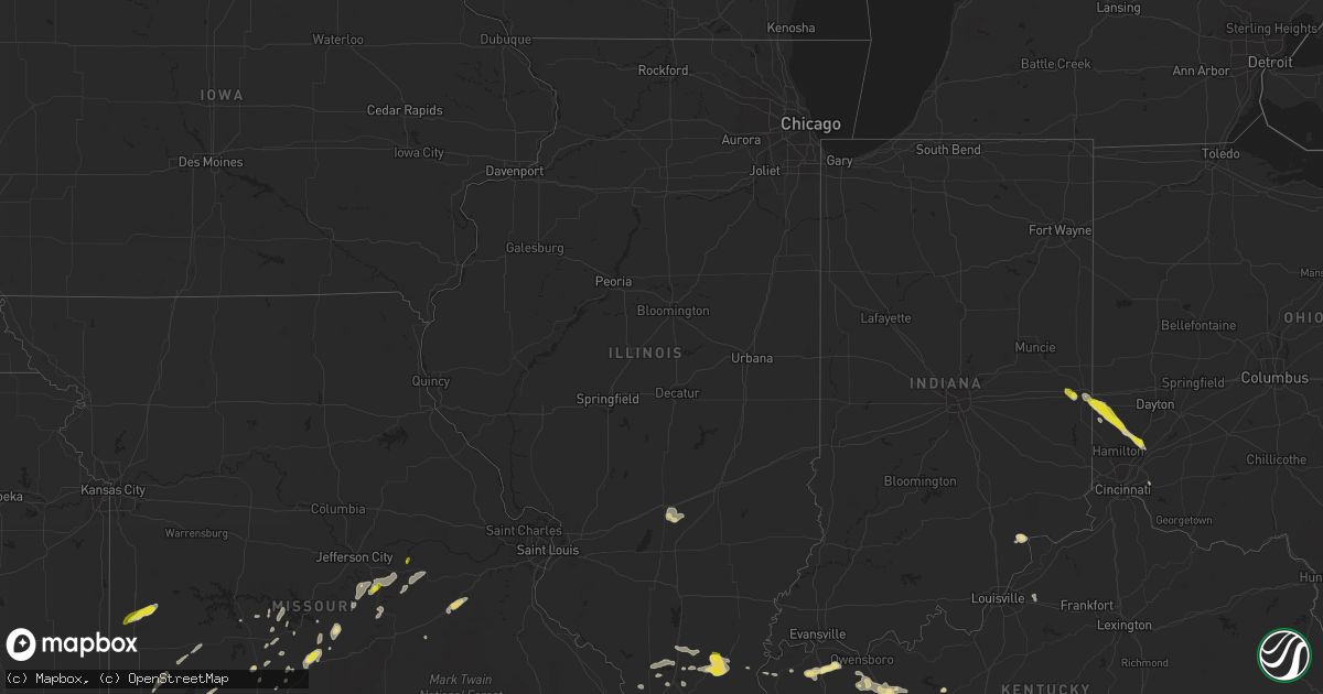
Hail Map in Illinois on May 20, 2018
Get this storm
May 20 map
$229
one time, instant access
Download today. No call, no setup
Keep the $229
Bought the map and want the full workflow? Apply the entire $229 to a subscription within 7 days. None of it is wasted.
Every map, not just this one
This buys you this map. Subscription and you get every map we run, in the markets you choose from a few cities to whole states to nationwide. Plus real-time alerts the moment a storm fires.
Contact data
Name, contact info, occupancy, even credit band for addresses in the footprint. You go from where it hit to who to call.
Become the source they trust
Unlimited branding weather history reports on demand. You already have the documented answer ready for the property owner, and you are the one who showed up with it.
Property data and RoofTrace estimates
Pull up any address you have got, its value and the exact code rules for that jurisdiction, straight from One Click Code. Then RoofTrace estimates the squares, pitch, and roof value, priced the way you price.
Storm reports in Illinois
Illinois
| Date | Description |
|---|---|
| 05/20/20183:45 PM CDT | Several power poles down... Multiple trees down... And a pivot irrigation unit was blown over south of junction. Time was estimated based off radar. |
| 05/20/20183:43 PM CDT | Large tree limb down in town. Relayed via twitter. |
| 05/20/20183:29 PM CDT | Several power poles snapped on illinois highway 34 near the intersection of highway 145. |
| 05/20/20183:05 PM CDT | Power lines down in carrier mills. |
| 05/20/20181:35 AM CDT | At 635 AM CDT, a severe thunderstorm was located over Reno, moving east at 25 mph. HAZARD...60 mph wind gusts and quarter size hail. SOURCE...Radar indicated. IMPACT...Hail damage to vehicles is expected. Expect wind damage to roofs, siding, and trees. Locations impacted include... Vandalia, Greenville, Pocahontas, Mulberry Grove, Sorento, Woburn, Van Burensburg, Reno, Pleasant Mound, Pittsburg, Shafter, Panama, Donnellson, Smithboro, Old Ripley, Bingham, Bayle City and Hagerstown.This includes Interstate 70 in Illinois between exits 36 and 61. |
| 05/19/201810:10 PM CDT | At 309 PM CDT, a severe thunderstorm was located near Harrisburg, moving east at 10 mph. HAZARD...60 mph wind gusts and quarter size hail. SOURCE...Radar indicated. IMPACT...Hail damage to vehicles is expected. Expect wind damage to roofs, siding, and trees. Locations impacted include... Harrisburg, Eldorado, Raleigh and Muddy. |
| 05/19/20189:42 PM CDT | At 242 PM CDT, severe thunderstorms were located along a line extending from near Tamms to near Mound City, moving east at 25 mph. HAZARD...60 mph wind gusts and quarter size hail. SOURCE...Radar indicated. IMPACT...Hail damage to vehicles is expected. Expect wind damage to roofs, siding, and trees. Locations impacted include... La Center, Barlow, Mound City and Olmsted. |
| 05/19/20189:18 PM CDT | At 218 PM CDT, severe thunderstorms were located along a line extending from Olive Branch to 6 miles north of Charleston, moving east at 25 mph. HAZARD...60 mph wind gusts and quarter size hail. SOURCE...Radar indicated. IMPACT...Hail damage to vehicles is expected. Expect wind damage to roofs, siding, and trees. Locations impacted include... Cairo, Mounds, Mound City, Olive Branch, Horseshoe Lake Conservation Area and Pulaski. |
| 05/19/20189:14 PM CDT | At 214 PM CDT, a severe thunderstorm was located near Tamms, or 11 miles east of Scott City, moving east at 15 mph. HAZARD...60 mph wind gusts and quarter size hail. SOURCE...Radar indicated. IMPACT...Hail damage to vehicles is expected. Expect wind damage to roofs, siding, and trees. Locations impacted include... Tamms. |
All States Impacted by Hail Map on May 20, 2018
Cities Impacted by Hail Map on May 20, 2018
- Altamont, TN
- Pelham, TN
- Hillsboro, TN
- Cave City, KY
- Savannah, TN
- Lutts, TN
- Harrisburg, IL
- Galatia, IL
- Grove Hill, AL
- Jackson, AL
- Laurel Hill, FL
- Black Rock, AR
- Pocahontas, AR
- Powhatan, AR
- Smithville, AR
- Portia, AR
- Walnut Ridge, AR
- Middletown, OH
- Spring, TX
- Tomball, TX
- Conroe, TX
- Olmstead, KY
- Allensville, KY
- Adairville, KY
- Jackson, MS
- Flora, MS
- Utica, MS
- Freeport, FL
- Morganfield, KY
- Brackettville, TX
- Laredo, TX
- Hebbronville, TX
- Baxter Springs, KS
- Galena, KS
- Columbus, KS
- Riverton, KS
- Millport, AL
- Clarksdale, MS
- Scottsville, VA
- Charlottesville, VA
- Palmyra, VA
- Quapaw, OK
- Greenfield, TN
- Westmoreland, TN
- Hartsville, TN
- Lafayette, TN
- Augusta, AR
- Van Horn, TX
- Corning, AR
- Piggott, AR
- Hartford, KY
- Diamond, MO
- Hanover, IN
- Lexington, IN
- Madison, IN
- Oran, MO
- Benton, MO
- Sikeston, MO
- Clanton, AL
- Sylacauga, AL
- Sturgis, KY
- Adams, TN
- Clarksville, TN
- Pollard, AR
- Dongola, IL
- Anna, IL
- Granite Falls, NC
- Dunlap, TN
- Martin, TN
- Cottage Grove, TN
- Paris, TN
- Dukedom, TN
- South Fulton, TN
- Puryear, TN
- Palmersville, TN
- Twin Falls, ID
- Golconda, IL
- Grantsburg, IL
- Lake Cormorant, MS
- Brevard, NC
- Cedar Mountain, NC
- Crocker, MO
- Iberia, MO
- Richland, MO
- Monroe, OH
- Atmore, AL
- Carthage, TX
- Long Branch, TX
- Lenoir, NC
- Hudson, NC
- Olivehill, TN
- Lexa, AR
- Goodwater, AL
- Henderson, KY
- Owensboro, KY
- Robards, KY
- Cobden, IL
- Alto Pass, IL
- Belmont, MS
- Red Bay, AL
- Vina, AL
- Golden, MS
- Tuscaloosa, AL
- Cottondale, AL
- Sabinal, TX
- Gallatin, TN
- Vienna, MO
- Dixon, MO
- Como, MS
- Tutwiler, MS
- Alligator, MS
- Duncan, MS
- Drew, MS
- Steelville, MO
- Bolivar, TN
- Ashland, MS
- Walnut, MS
- Falkner, MS
- Bertrand, MO
- East Prairie, MO
- Cash, AR
- Swifton, AR
- Shobonier, IL
- Vandalia, IL
- Brownstown, IL
- Saint Peter, IL
- Portland, TN
- Uvalde, TX
- Carrier Mills, IL
- Marion, IL
- Eldorado, IL
- Raleigh, IL
- Stonefort, IL
- Knobel, AR
- Dickson, TN
- Batesville, AR
- Hanceville, AL
- Hayden, AL
- Blue Mountain, MS
- Faunsdale, AL
- Newbern, AL
- Ripley, TN
- Talladega, AL
- Holly Springs, MS
- Jonesboro, AR
- Alicia, AR
- Hoxie, AR
- Paragould, AR
- Bono, AR
- Yazoo City, MS
- Camden, OH
- Bell City, MO
- Taneyville, MO
- Bradleyville, MO
- Gattman, MS
- Caledonia, MS
- Eaton, OH
- Climax Springs, MO
- Camdenton, MO
- Gravois Mills, MO
- Roach, MO
- Higginson, AR
- Searcy, AR
- Hendersonville, TN
- Bethpage, TN
- Brandon, MS
- Ellijay, GA
- Sharpsburg, GA
- Newnan, GA
- Sulphur Rock, AR
- Strawberry, AR
- Galena, MO
- Cape Fair, MO
- Marianna, AR
- Lebanon, MO
- Stoutland, MO
- Aubrey, AR
- Gideon, MO
- Holcomb, MO
- Campbell, MO
- Clarkton, MO
- Groveton, TX
- Moscow, TN
- Tamms, IL
- Atlanta, GA
- Cruger, MS
- Tchula, MS
- Cairo, IL
- Miller City, IL
- Thebes, IL
- Scott City, MO
- Stockton, MO
- Inverness, MS
- Vienna, IL
- Simpson, IL
- Greenville, SC
- Bedias, TX
- Iola, TX
- Lincolnton, GA
- Rich Hill, MO
- Butler, MO
- Enterprise, MS
- Arlington, TN
- Millington, TN
- Memphis, TN
- Oakland, KY
- Smiths Grove, KY
- Theodosia, MO
- Lineville, AL
- Delta, AL
- Wedowee, AL
- Valentine, TX
- Whites Creek, TN
- Joelton, TN
- Whitsett, TX
- Adolphus, KY
- Scottsville, KY
- Kirbyville, MO
- Powersite, MO
- Hollister, MO
- Chickamauga, GA
- Bessemer, AL
- Miami, OK
- Fairland, OK
- Cross Plains, TN
- Orlinda, TN
- D Hanis, TX
- Freeburg, MO
- Argyle, MO
- Somerville, TN
- Elkton, KY
- Guthrie, KY
- Beaver Dam, KY
- Nashville, TN
- Sullivan, MO
- Bourbon, MO
- Old Hickory, TN
- Goodlettsville, TN
- Madison, TN
- Falls City, TX
- Cotulla, TX
- Fowlerton, TX
- Tilden, TX
- Olaton, KY
- Luxora, AR
- Medon, TN
- Pinson, TN
- Mound City, IL
- Linn, MO
- Jourdanton, TX
- Hickory Valley, TN
- Portageville, MO
- Marston, MO
- Mounds, IL
- Calhoun, KY
- Horse Branch, KY
- Utica, KY
- Livermore, KY
- Dundee, KY
- Oxford, MS
- Etta, MS
- Thaxton, MS
- Bald Knob, AR
- Seneca, MO
- Neosho, MO
- Stewart, TN
- Magnolia, KY
- Tullahoma, TN
- Lynchburg, TN
- Vernon, AL
- Sarah, MS
- Dundee, MS
- Crenshaw, MS
- New Market, AL
- Butler, AL
- Shell Knob, MO
- Golden, MO
- Cave City, AR
- Watson, AR
- Tillar, AR
- Ozark, AL
- Porter, TX
- Leitchfield, KY
- Joplin, MO
- Oldfield, MO
- Ava, MO
- Chadwick, MO
- Boomer, NC
- Dayton, TN
- Petersburg, TN
- Fayetteville, TN
- Realitos, TX
- Rocksprings, TX
- Del Rio, TX
- Red Level, AL
- Newbern, TN
- Hickman, KY
- Springfield, TN
- Bradford, TN
- Rutherford, TN
- Shaw, MS
- Boyle, MS
- Graff, MO
- Mountain Grove, MO
- Cumberland City, TN
- Vanleer, TN
- Cumberland Furnace, TN
- Belfast, TN
- Satartia, MS
- Castalian Springs, TN
- Pearsall, TX
- Lilbourn, MO
- New Madrid, MO
- Carthage, MO
- Blytheville, AR
- Abbeville, MS
- Westport, TN
- Huntingdon, TN
- Jackson, TN
- Vicksburg, MS
- Eglin Afb, FL
- Tenaha, TX
- McEwen, TN
- Henderson, TN
- Jerico Springs, MO
- Sheldon, MO
- Lamar, MO
- Centerville, IN
- Fairmont, NC
- Beaverton, AL
- Camden, MS
- Beech Grove, AR
- Park City, KY
- Owensville, MO
- Bland, MO
- Three Rivers, TX
- Rueter, MO
- Cedarcreek, MO
- Idaho Falls, ID
- Bowling Green, KY
- Wyandotte, OK
- Rocky Hill, KY
- Sidon, MS
- Nacogdoches, TX
- Newport, AR
- Vinita, OK
- West Helena, AR
- Horse Cave, KY
- Panama City, FL
- Edwards, MS
- Tremont, MS
- Fulton, MS
- Dadeville, MO
- Aldrich, MO
- Walnut Grove, MO
- White House, TN
- Cottontown, TN
- Quinton, AL
- Mulga, AL
- Brookland, AR
- Lynnville, TN
- Pulaski, TN
- Protem, MO
- Treece, KS
- Byhalia, MS
- Corydon, KY
- Cordova, AL
- Somerville, OH
- Palestine, AR
- Colt, AR
- Mount Sherman, KY
- Buffalo, KY
- Ethel, MS
- Franklin, OH
- Trenton, OH
- Lebanon, OH
- Richmond, IN
- Dyer, TN
- Sale Creek, TN
- Graysville, TN
- El Dorado Springs, MO
- Dawson Springs, KY
- Sautee Nacoochee, GA
- Merigold, MS
- Rosedale, MS
- Cleveland, MS
- Koeltztown, MO
- Belle, MO
- Steele, MO
- Marion, KY
- Detroit, AL
- Sulligent, AL
- Florence, AL
- Brookwood, AL
- Sedalia, CO
- Thorndale, TX
- Franklin, GA
- Metropolis, IL
- Kennedy, AL
- Zapata, TX
- Rigby, ID
- Coila, MS
- Grand Junction, TN
- McClure, IL
- Jonesboro, IL
- Itta Bena, MS
- Russellville, KY
- Cedar Hill, TN
- Lebanon, TN
- Pelahatchie, MS
- Westphalia, MO
- Creal Springs, IL
- Ozark, IL
- Gallion, AL
- Omaha, AR
- Lead Hill, AR
- Beulah, MS
- Chattanooga, TN
- Sebree, KY
- Lewisburg, TN
- Waterloo, AL
- Madison, MS
- Canton, MS
- Hayden, CO
- Reeds Spring, MO
- Meta, MO
- Pleasant View, TN
- Urbana, MO
- Tunas, MO
- Princeton, KY
- Fredonia, KY
- Griffithville, AR
- Everton, MO
- Mountain View, AR
- Warrior, AL
- Hockley, TX
- Buffalo, MO
- Mount Enterprise, TX
- Henderson, TX
- Concepcion, TX
- Magnolia, TX
- New Concord, KY
- Murray, KY
- Bentonia, MS
- Linden, AL
- Phillipsburg, MO
- Long Lane, MO
- Lamar, MS
- Pulaski, IL
- Villa Ridge, IL
- Schlater, MS
- Whiteville, TN
- Ellisville, MS
- Olive Branch, IL
- Charleston, MO
- Franklin, KY
- Decatur, TN
- Sallis, MS
- Century, FL
- Cape Girardeau, MO
- Clarkesville, GA
- Piedmont, AL
- Goreville, IL
- Makanda, IL
- Erin, TN
- Woodlawn, TN
- Ashland, AL
- Freer, TX
- Morrison, MO
- Cincinnati, OH
- Milford, OH
- Yellville, AR
- Peel, AR
- Hickory Ridge, AR
- Conway, MO
- Lynn, AR
- Rector, AR
- Caneyville, KY
- Guerra, TX
- Louisburg, MO
- Mill Spring, NC
- Andalusia, AL
- Indian Mound, TN
- Coldwater, MS
- Senatobia, MS
- Prattsville, AR
- Sheridan, AR
- Ruleville, MS
- Wilmer, AL
- Carbondale, IL
- Carterville, IL
- Herrin, IL
- Richards, TX
- Anderson, TX
- Pollok, TX
- Ripley, MS
- Myrtle, MS
- Montreal, MO
- Greensboro, AL
- Uniontown, AL
- Morganton, NC
- Franklin, TN
- Des Arc, AR
- Simpsonville, KY
- Louisville, KY
- Declo, ID
- Rupert, ID
- Hickory Flat, MS
- Waverly, TN
- Brentwood, TN
- Greenwood, MS
- Franklin, AL
- Edwards, MO
- Warsaw, MO
- Kenton, TN
- Ullin, IL
- Barlow, KY
- White Bluff, TN
- Charlotte, TN
- Osceola, AR
- Millerville, AL
- Trenton, TN
- Matthews, MO
- Rose Bud, AR
- Estill Springs, TN
- Lexington, TN
- Beckville, TX
- Richton, MS
- Oakland, MS
- Water Valley, MS
- McCrory, AR
- Taylors, SC
- Brumley, MO
- Collins, MO
- Troy, AL
- Hernando, MS
- Woodland, AL
- Heflin, AL
- Ranburne, AL
- Graham, AL
- Thomson, GA
- Palmyra, TN
- Ovett, MS
- Cuero, TX
- Junction, IL
- Cypress, TX
- Brownsville, KY
- Marmaduke, AR
- Melbourne, AR
- Calico Rock, AR
- Kevil, KY
- West Paducah, KY
- Macks Creek, MO
- Thompsonville, IL
- Pittsburg, IL
- West Frankfort, IL
- Johnston City, IL
- Pleasanton, TX
- Cambridge City, IN
- Greens Fork, IN
- Benavides, TX
- Centerville, TX
- Saffell, AR
- Shelby, MS
- Lyon, MS
- Mound Bayou, MS
- Halls, TN
- Glasgow, KY
- Wickliffe, KY
- Marvell, AR
- Forsyth, MO
- Branson, MO
- Walnut Shade, MO
- Rockaway Beach, MO
- Potts Camp, MS
- Gunnison, MS
- Paducah, KY
- Kellyton, AL
- Pennington, AL
- Sweet Water, AL
- Ward, AL
- Toone, TN
- Easley, SC
- Reform, AL
- Burley, ID
- Roopville, GA
- Gibson, MO
- Tiptonville, TN
- Hume, MO
- New Paris, OH


