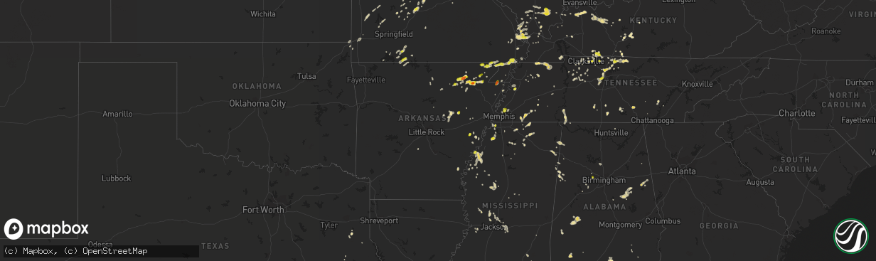
Hail Map in Arkansas on May 20, 2018
The weather event in Arkansas on May 20, 2018 includes Hail map. 19 states and 590 cities were impacted and suffered possible damage. The total estimated number of properties impacted is 4,612.
Want more than just the map?
Turn this storm into a full workflow.
- Owner + property data so you know who to knock
- OnDemand branded weather history reports to win the "did we even have hail?" argument
- RoofTrace estimate so reps stop guessing numbers at the door
Bought this map? Upgrade within 7 days and we'll credit the $230. (10-15 min setup call)
Hail
4,612
Estimated number of impacted properties by a 1.00" hail or larger873
Estimated number of impacted properties by a 1.75" hail or larger0
Estimated number of impacted properties by a 2.50" hail or largerStorm reports in Arkansas
Arkansas
| Date | Description |
|---|---|
| 05/20/20184:40 PM CDT | Several trees down some on power lines. Shed blown over.18 wheeler truck blown over on highway 64 going into earle. |
| 05/20/20183:36 PM CDT | Quarter sized hail highway 69 east of paragould. |
| 05/20/20183:25 PM CDT | Pea to quarter sized hail. |
| 05/20/20183:15 PM CDT | Quarter size hail between oak grove and lafe. |
| 05/20/20182:45 PM CDT | Quarter to golf ball sized hail. |
| 05/20/20182:00 PM CDT | Quarter size hail in davidsonville state park. |
| 05/20/20182:00 PM CDT | A local report indicates 1.00 inch wind near MCDOUGAL |
| 05/20/20181:35 PM CDT | Hail ranged dime size to golfball. |
| 05/20/201812:49 PM CDT | A local report indicates 1.00 inch wind near SMITHVILLE |
| 05/20/20187:44 AM CDT | At 1244 PM CDT, a severe thunderstorm was located near Lynn, or 7 miles west of Lake Charles State Park, moving east at 10 mph. HAZARD...60 mph wind gusts and quarter size hail. SOURCE...Radar indicated. IMPACT...Hail damage to vehicles is expected. Expect wind damage to roofs, siding, and trees. Locations impacted include... Pocahontas, Walnut Ridge, Hoxie, Black Rock, Lake Charles State Park, Imboden, Ravenden, Reyno, College City, Portia, Biggers, Strawberry, Lynn, O'Kean, Minturn, Annieville, Attica, Smithville, Powhatan and Whiskerville. |
| 05/19/201811:27 PM CDT | At 427 PM CDT, a severe thunderstorm was located 7 miles west of Unionville, or 12 miles north of Ripley, moving east at 30 mph. HAZARD...60 mph wind gusts and quarter size hail. SOURCE...Radar indicated. IMPACT...Hail damage to vehicles is expected. Expect wind damage to roofs, siding, and trees. Locations impacted include... Dyersburg, Ripley, Newbern, Halls, Ridgely, Obion, Cloverdale, Bradleytown, Unionville, Miston, Cottonwood Grove, Gates, Trimble, Cat Corner, Edith, Fowlkes, Bonicord, Locust Grove, Jenkinsville and Maxey. |
| 05/19/201811:18 PM CDT | At 418 PM CDT, a severe thunderstorm was located over Aubrey, or 9 miles north of Marvell, moving north at 5 mph. HAZARD...60 mph wind gusts and quarter size hail. SOURCE...Radar indicated. IMPACT...Hail damage to vehicles is expected. Expect wind damage to roofs, siding, and trees. Locations impacted include... Moro, Aubrey, Felton, Vineyard, Oak Forest, Westor, Big Creek Corner and Thomasville. |
| 05/19/201811:04 PM CDT | At 404 PM CDT, a severe thunderstorm was located near Sherard, or near Clarksdale, moving northeast at 10 mph. HAZARD...60 mph wind gusts and quarter size hail. SOURCE...Radar indicated. IMPACT...Hail damage to vehicles is expected. Expect wind damage to roofs, siding, and trees. Locations impacted include... Clarksdale, Kings, Sherard, Lyon, Clover Hill, Bobo, Farrell and Beverly. |
| 05/19/201810:56 PM CDT | At 356 PM CDT, a severe thunderstorm was located near Ellendale, or near Bartlett, and is nearly stationary. HAZARD...70 mph wind gusts and half dollar size hail. SOURCE...Radar indicated. IMPACT...Hail damage to vehicles is expected. Expect considerable tree damage. Wind damage is also likely to mobile homes, roofs, and outbuildings. Locations impacted include... Bartlett, Millington, Memphis, Lakeland, Arlington, Munford, Brighton, Ellendale, Dixonville, Frayser, Tipton, Atoka, Mason, Gallaway, Gilt Edge, Barretville, Egypt, Griffin Corner, Quito and Woodstock. |
| 05/19/201810:53 PM CDT | At 353 PM CDT, a severe thunderstorm was located over Cushman, or 8 miles northwest of Batesville, moving northeast at 15 mph. HAZARD...60 mph wind gusts and quarter size hail. SOURCE...Radar indicated. IMPACT...Hail damage to vehicles is expected. Expect wind damage to roofs, siding, and trees. Locations impacted include... Batesville... Cushman... Mount Pleasant... Bethesda... Lafferty... Sandtown... Pfeiffer... |
| 05/19/201810:09 PM CDT | At 309 PM CDT, a severe thunderstorm was located over Crowleys Ridge State Park, moving east at 35 mph. HAZARD...Ping pong ball size hail and 60 mph wind gusts. SOURCE...Radar indicated. IMPACT...People and animals outdoors will be injured. Expect hail damage to roofs, siding, windows, and vehicles. Expect wind damage to roofs, siding, and trees. Locations impacted include... Jonesboro, Paragould, Bono, Brookland, Crowleys Ridge State Park, Lake Frierson State Park, Oak Grove Heights, Walcott, Apt, Valley View, Farrville, Halliday, Cary, Bethel, Finch, Lorado, Herndon, Noxburn, Herman and Cotton Belt. |
| 05/19/20189:40 PM CDT | At 240 PM CDT, a severe thunderstorm was located over Holcomb, or near Campbell, moving east at 35 mph. HAZARD...Ping pong ball size hail and 60 mph wind gusts. SOURCE...Radar indicated. IMPACT...People and animals outdoors will be injured. Expect hail damage to roofs, siding, windows, and vehicles. Expect wind damage to roofs, siding, and trees. Locations impacted include... Malden, Piggott, Campbell, Clarkton, Holcomb, St. Francis, Saint Francis, Rhyne, Valley Ridge, Providence, Morris State Park, Brian, Baird, McGuires and Townley. |
| 05/19/20189:37 PM CDT | At 237 PM CDT, a severe thunderstorm was located near Fontaine, or near Walnut Ridge, moving east at 15 mph. HAZARD...Golf ball size hail and 60 mph wind gusts. SOURCE...Radar indicated. IMPACT...People and animals outdoors will be injured. Expect hail damage to roofs, siding, windows, and vehicles. Expect wind damage to roofs, siding, and trees. Locations impacted include... Paragould, Oak Grove Heights, Lafe, O'Kean, Delaplaine, Evening Star, Beech Grove, Whiskerville, Stonewall, Giles Spur, Case, Stanford, Gainesville, Light, Walnut Corner, Faulknerville and Crowley's Ridge State Park. |
| 05/19/20189:30 PM CDT | At 229 PM CDT, a severe thunderstorm was located near Fontaine, or near Bono, moving east at 10 mph. HAZARD...60 mph wind gusts and quarter size hail. SOURCE...Radar indicated. IMPACT...Hail damage to vehicles is expected. Expect wind damage to roofs, siding, and trees. A brief tornado is possible near Sedgwick and Fontaine over the next 15 minutes. Locations impacted include... Jonesboro, Bono, Crowleys Ridge State Park, Lake Frierson State Park, Cash, Egypt, Fontaine, Walcott, Sedgwick, Herman, Dryden, Dorothy, Winesburg, Lanieve, Finch, Lorado, Herndon and Crowley's Ridge State Park. |
| 05/19/20189:05 PM CDT | At 205 PM CDT, a severe thunderstorm was located over Minturn, or near Hoxie, moving east at 25 mph. HAZARD...60 mph wind gusts and half dollar size hail. SOURCE...Radar indicated. IMPACT...Hail damage to vehicles is expected. Expect wind damage to roofs, siding, and trees. Locations impacted include... Walnut Ridge, Hoxie, Black Rock, Lake Charles State Park, College City, Portia, Alicia, Minturn, Sedgwick, Powhatan, Strangers Home, Giles Spur, Eaton, Lauratown, Clover Bend, Calvin, Dicus, Coffman, Arbor Grove and Powhatan Historic State Park. |
| 05/19/20188:51 PM CDT | At 151 PM CDT, a severe thunderstorm was located near O'Kean, or 8 miles northwest of Crowleys Ridge State Park, moving east at 15 mph. HAZARD...60 mph wind gusts and half dollar size hail. SOURCE...Radar indicated. IMPACT...Hail damage to vehicles is expected. Expect wind damage to roofs, siding, and trees. Locations impacted include... Paragould, Marmaduke, Oak Grove Heights, Lafe, O'Kean, Peach Orchard, Delaplaine, Evening Star, Beech Grove, Whiskerville, Stonewall, Giles Spur, Tipperary, Case, Brookings, Halliday, Light, Faulknerville, Noxburn and Cotton Belt. |
| 05/19/20188:42 PM CDT | At 142 PM CDT, a severe thunderstorm was located over Strawberry, or 13 miles southwest of Lake Charles State Park, moving northeast at 25 mph. HAZARD...60 mph wind gusts and quarter size hail. SOURCE...Radar indicated. IMPACT...Hail damage to vehicles is expected. Expect wind damage to roofs, siding, and trees. Locations impacted include... Strawberry, Lynn, Smithville, Driftwood and Eaton. |
| 05/19/20188:40 PM CDT | At 140 PM CDT, a severe thunderstorm was located over McDougal, or 10 miles east of Corning, moving northeast at 25 mph. HAZARD...60 mph wind gusts and quarter size hail. SOURCE...Radar indicated. IMPACT...Hail damage to vehicles is expected. Expect wind damage to roofs, siding, and trees. Locations impacted include... Malden, Piggott, Campbell, Chalk Bluff Natural Area, Clarkton, Holcomb, St. Francis, Pollard, Greenway, McDougal, Saint Francis, Glennonville, Crockett, Hickoria, Valley Ridge, Providence, Morris State Park, Wilhelmina, Brian and Chalk Bluff Battlefield Park. |
| 05/19/20188:40 PM CDT | At 140 PM CDT, a severe thunderstorm was located near Strawberry, or 14 miles southwest of Lake Charles State Park, moving northeast at 10 mph. HAZARD...60 mph wind gusts and quarter size hail. SOURCE...Radar indicated. IMPACT...Hail damage to vehicles is expected. Expect wind damage to roofs, siding, and trees. Locations impacted include... Aetna... Calamine... |
| 05/19/20188:23 PM CDT | At 123 PM CDT, a severe thunderstorm was located over Lake Charles State Park, moving east at 10 mph. HAZARD...Ping pong ball size hail and 60 mph wind gusts. SOURCE...Radar indicated. IMPACT...People and animals outdoors will be injured. Expect hail damage to roofs, siding, windows, and vehicles. Expect wind damage to roofs, siding, and trees. Locations impacted include... Walnut Ridge, Hoxie, Black Rock, Lake Charles State Park, College City, Portia, Powhatan, Shannon, Eaton, Lauratown, Dicus, Fender, Elnora, Coffman, Manson, Lesterville, Arbor Grove, Powhatan Historic State Park and Davidsonville Historic State Park. |
| 05/19/20188:02 PM CDT | At 102 PM CDT, a severe thunderstorm was located near Corning, moving east at 20 mph. HAZARD...60 mph wind gusts and quarter size hail. SOURCE...Radar indicated. IMPACT...Hail damage to vehicles is expected. Expect wind damage to roofs, siding, and trees. Locations impacted include... Piggott, Corning, Knobel, Pollard, McDougal, Crockett, Tipperary and Hickoria. |
All States Impacted by Hail Map on May 20, 2018
Cities Impacted by Hail Map on May 20, 2018
- Altamont, TN
- Pelham, TN
- Hillsboro, TN
- Cave City, KY
- Savannah, TN
- Lutts, TN
- Harrisburg, IL
- Galatia, IL
- Grove Hill, AL
- Jackson, AL
- Laurel Hill, FL
- Black Rock, AR
- Pocahontas, AR
- Powhatan, AR
- Smithville, AR
- Portia, AR
- Walnut Ridge, AR
- Middletown, OH
- Spring, TX
- Tomball, TX
- Conroe, TX
- Olmstead, KY
- Allensville, KY
- Adairville, KY
- Jackson, MS
- Flora, MS
- Utica, MS
- Freeport, FL
- Morganfield, KY
- Brackettville, TX
- Laredo, TX
- Hebbronville, TX
- Baxter Springs, KS
- Galena, KS
- Columbus, KS
- Riverton, KS
- Millport, AL
- Clarksdale, MS
- Scottsville, VA
- Charlottesville, VA
- Palmyra, VA
- Quapaw, OK
- Greenfield, TN
- Westmoreland, TN
- Hartsville, TN
- Lafayette, TN
- Augusta, AR
- Van Horn, TX
- Corning, AR
- Piggott, AR
- Hartford, KY
- Diamond, MO
- Hanover, IN
- Lexington, IN
- Madison, IN
- Oran, MO
- Benton, MO
- Sikeston, MO
- Clanton, AL
- Sylacauga, AL
- Sturgis, KY
- Adams, TN
- Clarksville, TN
- Pollard, AR
- Dongola, IL
- Anna, IL
- Granite Falls, NC
- Dunlap, TN
- Martin, TN
- Cottage Grove, TN
- Paris, TN
- Dukedom, TN
- South Fulton, TN
- Puryear, TN
- Palmersville, TN
- Twin Falls, ID
- Golconda, IL
- Grantsburg, IL
- Lake Cormorant, MS
- Brevard, NC
- Cedar Mountain, NC
- Crocker, MO
- Iberia, MO
- Richland, MO
- Monroe, OH
- Atmore, AL
- Carthage, TX
- Long Branch, TX
- Lenoir, NC
- Hudson, NC
- Olivehill, TN
- Lexa, AR
- Goodwater, AL
- Henderson, KY
- Owensboro, KY
- Robards, KY
- Cobden, IL
- Alto Pass, IL
- Belmont, MS
- Red Bay, AL
- Vina, AL
- Golden, MS
- Tuscaloosa, AL
- Cottondale, AL
- Sabinal, TX
- Gallatin, TN
- Vienna, MO
- Dixon, MO
- Como, MS
- Tutwiler, MS
- Alligator, MS
- Duncan, MS
- Drew, MS
- Steelville, MO
- Bolivar, TN
- Ashland, MS
- Walnut, MS
- Falkner, MS
- Bertrand, MO
- East Prairie, MO
- Cash, AR
- Swifton, AR
- Shobonier, IL
- Vandalia, IL
- Brownstown, IL
- Saint Peter, IL
- Portland, TN
- Uvalde, TX
- Carrier Mills, IL
- Marion, IL
- Eldorado, IL
- Raleigh, IL
- Stonefort, IL
- Knobel, AR
- Dickson, TN
- Batesville, AR
- Hanceville, AL
- Hayden, AL
- Blue Mountain, MS
- Faunsdale, AL
- Newbern, AL
- Ripley, TN
- Talladega, AL
- Holly Springs, MS
- Jonesboro, AR
- Alicia, AR
- Hoxie, AR
- Paragould, AR
- Bono, AR
- Yazoo City, MS
- Camden, OH
- Bell City, MO
- Taneyville, MO
- Bradleyville, MO
- Gattman, MS
- Caledonia, MS
- Eaton, OH
- Climax Springs, MO
- Camdenton, MO
- Gravois Mills, MO
- Roach, MO
- Higginson, AR
- Searcy, AR
- Hendersonville, TN
- Bethpage, TN
- Brandon, MS
- Ellijay, GA
- Sharpsburg, GA
- Newnan, GA
- Sulphur Rock, AR
- Strawberry, AR
- Galena, MO
- Cape Fair, MO
- Marianna, AR
- Lebanon, MO
- Stoutland, MO
- Aubrey, AR
- Gideon, MO
- Holcomb, MO
- Campbell, MO
- Clarkton, MO
- Groveton, TX
- Moscow, TN
- Tamms, IL
- Atlanta, GA
- Cruger, MS
- Tchula, MS
- Cairo, IL
- Miller City, IL
- Thebes, IL
- Scott City, MO
- Stockton, MO
- Inverness, MS
- Vienna, IL
- Simpson, IL
- Greenville, SC
- Bedias, TX
- Iola, TX
- Lincolnton, GA
- Rich Hill, MO
- Butler, MO
- Enterprise, MS
- Arlington, TN
- Millington, TN
- Memphis, TN
- Oakland, KY
- Smiths Grove, KY
- Theodosia, MO
- Lineville, AL
- Delta, AL
- Wedowee, AL
- Valentine, TX
- Whites Creek, TN
- Joelton, TN
- Whitsett, TX
- Adolphus, KY
- Scottsville, KY
- Kirbyville, MO
- Powersite, MO
- Hollister, MO
- Chickamauga, GA
- Bessemer, AL
- Miami, OK
- Fairland, OK
- Cross Plains, TN
- Orlinda, TN
- D Hanis, TX
- Freeburg, MO
- Argyle, MO
- Somerville, TN
- Elkton, KY
- Guthrie, KY
- Beaver Dam, KY
- Nashville, TN
- Sullivan, MO
- Bourbon, MO
- Old Hickory, TN
- Goodlettsville, TN
- Madison, TN
- Falls City, TX
- Cotulla, TX
- Fowlerton, TX
- Tilden, TX
- Olaton, KY
- Luxora, AR
- Medon, TN
- Pinson, TN
- Mound City, IL
- Linn, MO
- Jourdanton, TX
- Hickory Valley, TN
- Portageville, MO
- Marston, MO
- Mounds, IL
- Calhoun, KY
- Horse Branch, KY
- Utica, KY
- Livermore, KY
- Dundee, KY
- Oxford, MS
- Etta, MS
- Thaxton, MS
- Bald Knob, AR
- Seneca, MO
- Neosho, MO
- Stewart, TN
- Magnolia, KY
- Tullahoma, TN
- Lynchburg, TN
- Vernon, AL
- Sarah, MS
- Dundee, MS
- Crenshaw, MS
- New Market, AL
- Butler, AL
- Shell Knob, MO
- Golden, MO
- Cave City, AR
- Watson, AR
- Tillar, AR
- Ozark, AL
- Porter, TX
- Leitchfield, KY
- Joplin, MO
- Oldfield, MO
- Ava, MO
- Chadwick, MO
- Boomer, NC
- Dayton, TN
- Petersburg, TN
- Fayetteville, TN
- Realitos, TX
- Rocksprings, TX
- Del Rio, TX
- Red Level, AL
- Newbern, TN
- Hickman, KY
- Springfield, TN
- Bradford, TN
- Rutherford, TN
- Shaw, MS
- Boyle, MS
- Graff, MO
- Mountain Grove, MO
- Cumberland City, TN
- Vanleer, TN
- Cumberland Furnace, TN
- Belfast, TN
- Satartia, MS
- Castalian Springs, TN
- Pearsall, TX
- Lilbourn, MO
- New Madrid, MO
- Carthage, MO
- Blytheville, AR
- Abbeville, MS
- Westport, TN
- Huntingdon, TN
- Jackson, TN
- Vicksburg, MS
- Eglin Afb, FL
- Tenaha, TX
- McEwen, TN
- Henderson, TN
- Jerico Springs, MO
- Sheldon, MO
- Lamar, MO
- Centerville, IN
- Fairmont, NC
- Beaverton, AL
- Camden, MS
- Beech Grove, AR
- Park City, KY
- Owensville, MO
- Bland, MO
- Three Rivers, TX
- Rueter, MO
- Cedarcreek, MO
- Idaho Falls, ID
- Bowling Green, KY
- Wyandotte, OK
- Rocky Hill, KY
- Sidon, MS
- Nacogdoches, TX
- Newport, AR
- Vinita, OK
- West Helena, AR
- Horse Cave, KY
- Panama City, FL
- Edwards, MS
- Tremont, MS
- Fulton, MS
- Dadeville, MO
- Aldrich, MO
- Walnut Grove, MO
- White House, TN
- Cottontown, TN
- Quinton, AL
- Mulga, AL
- Brookland, AR
- Lynnville, TN
- Pulaski, TN
- Protem, MO
- Treece, KS
- Byhalia, MS
- Corydon, KY
- Cordova, AL
- Somerville, OH
- Palestine, AR
- Colt, AR
- Mount Sherman, KY
- Buffalo, KY
- Ethel, MS
- Franklin, OH
- Trenton, OH
- Lebanon, OH
- Richmond, IN
- Dyer, TN
- Sale Creek, TN
- Graysville, TN
- El Dorado Springs, MO
- Dawson Springs, KY
- Sautee Nacoochee, GA
- Merigold, MS
- Rosedale, MS
- Cleveland, MS
- Koeltztown, MO
- Belle, MO
- Steele, MO
- Marion, KY
- Detroit, AL
- Sulligent, AL
- Florence, AL
- Brookwood, AL
- Sedalia, CO
- Thorndale, TX
- Franklin, GA
- Metropolis, IL
- Kennedy, AL
- Zapata, TX
- Rigby, ID
- Coila, MS
- Grand Junction, TN
- McClure, IL
- Jonesboro, IL
- Itta Bena, MS
- Russellville, KY
- Cedar Hill, TN
- Lebanon, TN
- Pelahatchie, MS
- Westphalia, MO
- Creal Springs, IL
- Ozark, IL
- Gallion, AL
- Omaha, AR
- Lead Hill, AR
- Beulah, MS
- Chattanooga, TN
- Sebree, KY
- Lewisburg, TN
- Waterloo, AL
- Madison, MS
- Canton, MS
- Hayden, CO
- Reeds Spring, MO
- Meta, MO
- Pleasant View, TN
- Urbana, MO
- Tunas, MO
- Princeton, KY
- Fredonia, KY
- Griffithville, AR
- Everton, MO
- Mountain View, AR
- Warrior, AL
- Hockley, TX
- Buffalo, MO
- Mount Enterprise, TX
- Henderson, TX
- Concepcion, TX
- Magnolia, TX
- New Concord, KY
- Murray, KY
- Bentonia, MS
- Linden, AL
- Phillipsburg, MO
- Long Lane, MO
- Lamar, MS
- Pulaski, IL
- Villa Ridge, IL
- Schlater, MS
- Whiteville, TN
- Ellisville, MS
- Olive Branch, IL
- Charleston, MO
- Franklin, KY
- Decatur, TN
- Sallis, MS
- Century, FL
- Cape Girardeau, MO
- Clarkesville, GA
- Piedmont, AL
- Goreville, IL
- Makanda, IL
- Erin, TN
- Woodlawn, TN
- Ashland, AL
- Freer, TX
- Morrison, MO
- Cincinnati, OH
- Milford, OH
- Yellville, AR
- Peel, AR
- Hickory Ridge, AR
- Conway, MO
- Lynn, AR
- Rector, AR
- Caneyville, KY
- Guerra, TX
- Louisburg, MO
- Mill Spring, NC
- Andalusia, AL
- Indian Mound, TN
- Coldwater, MS
- Senatobia, MS
- Prattsville, AR
- Sheridan, AR
- Ruleville, MS
- Wilmer, AL
- Carbondale, IL
- Carterville, IL
- Herrin, IL
- Richards, TX
- Anderson, TX
- Pollok, TX
- Ripley, MS
- Myrtle, MS
- Montreal, MO
- Greensboro, AL
- Uniontown, AL
- Morganton, NC
- Franklin, TN
- Des Arc, AR
- Simpsonville, KY
- Louisville, KY
- Declo, ID
- Rupert, ID
- Hickory Flat, MS
- Waverly, TN
- Brentwood, TN
- Greenwood, MS
- Franklin, AL
- Edwards, MO
- Warsaw, MO
- Kenton, TN
- Ullin, IL
- Barlow, KY
- White Bluff, TN
- Charlotte, TN
- Osceola, AR
- Millerville, AL
- Trenton, TN
- Matthews, MO
- Rose Bud, AR
- Estill Springs, TN
- Lexington, TN
- Beckville, TX
- Richton, MS
- Oakland, MS
- Water Valley, MS
- McCrory, AR
- Taylors, SC
- Brumley, MO
- Collins, MO
- Troy, AL
- Hernando, MS
- Woodland, AL
- Heflin, AL
- Ranburne, AL
- Graham, AL
- Thomson, GA
- Palmyra, TN
- Ovett, MS
- Cuero, TX
- Junction, IL
- Cypress, TX
- Brownsville, KY
- Marmaduke, AR
- Melbourne, AR
- Calico Rock, AR
- Kevil, KY
- West Paducah, KY
- Macks Creek, MO
- Thompsonville, IL
- Pittsburg, IL
- West Frankfort, IL
- Johnston City, IL
- Pleasanton, TX
- Cambridge City, IN
- Greens Fork, IN
- Benavides, TX
- Centerville, TX
- Saffell, AR
- Shelby, MS
- Lyon, MS
- Mound Bayou, MS
- Halls, TN
- Glasgow, KY
- Wickliffe, KY
- Marvell, AR
- Forsyth, MO
- Branson, MO
- Walnut Shade, MO
- Rockaway Beach, MO
- Potts Camp, MS
- Gunnison, MS
- Paducah, KY
- Kellyton, AL
- Pennington, AL
- Sweet Water, AL
- Ward, AL
- Toone, TN
- Easley, SC
- Reform, AL
- Burley, ID
- Roopville, GA
- Gibson, MO
- Tiptonville, TN
- Hume, MO
- New Paris, OH


