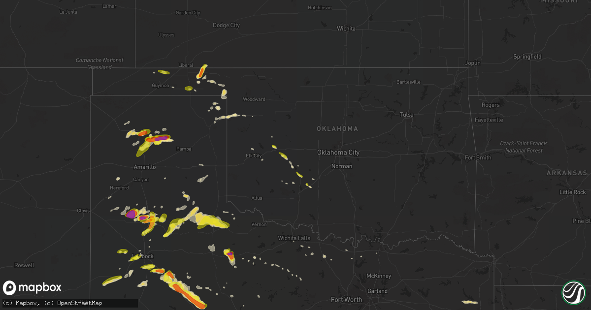
Hail Map in Oklahoma on May 17, 2018
Get this storm
May 17 map
$229
one time, instant access
Download today. No call, no setup
Keep the $229
Bought the map and want the full workflow? Apply the entire $229 to a subscription within 7 days. None of it is wasted.
Every map, not just this one
This buys you this map. Subscription and you get every map we run, in the markets you choose from a few cities to whole states to nationwide. Plus real-time alerts the moment a storm fires.
Contact data
Name, contact info, occupancy, even credit band for addresses in the footprint. You go from where it hit to who to call.
Become the source they trust
Unlimited branding weather history reports on demand. You already have the documented answer ready for the property owner, and you are the one who showed up with it.
Property data and RoofTrace estimates
Pull up any address you have got, its value and the exact code rules for that jurisdiction, straight from One Click Code. Then RoofTrace estimates the squares, pitch, and roof value, priced the way you price.
Storm reports in Oklahoma
Oklahoma
| Date | Description |
|---|---|
| 05/17/20186:04 PM CDT | A local report indicates 1.00 inch wind near 6 NE HOUGH |
| 05/17/20184:10 PM CDT | Time based on radar. |
| 05/17/20184:06 PM CDT | A local report indicates 1.00 inch wind near CYRIL |
| 05/17/20183:32 PM CDT | A local report indicates 1.00 inch wind near FORT COBB |
| 05/17/20181:55 PM CDT | A local report indicates 1.00 inch wind near ARAPAHO |
| 05/17/201810:50 AM CDT | A local report indicates 1.25 inch wind near 12 SW SHATTUCK |
| 05/17/201810:15 AM CDT | A local report indicates 1.75 inch wind near 6 E FLORIS |
| 05/17/201810:10 AM CDT | A local report indicates 1.75 inch wind near 5 E FLORIS |
| 05/17/20185:35 AM CDT | At 1035 AM CDT, a severe thunderstorm was located over Higgins Texas, moving east-northeast at 30 mph. HAZARD...60 mph wind gusts and quarter size hail. SOURCE...Radar indicated. IMPACT...Hail damage to vehicles is expected. Expect wind damage to roofs, siding, and trees. Locations impacted include... Shattuck, Arnett, Gage and Fargo. |
| 05/17/20185:34 AM CDT | At 1034 AM CDT, a severe thunderstorm was located 5 miles north of Forgan, or 11 miles north of Beaver, moving northeast at 30 mph. HAZARD...Ping pong ball size hail and 60 mph wind gusts. SOURCE...Radar indicated. IMPACT...People and animals outdoors will be injured. Expect hail damage to roofs, siding, windows, and vehicles. Expect wind damage to roofs, siding, and trees. Locations impacted include... Meade State Park. |
| 05/17/20182:27 AM CDT | At 726 PM CDT, a severe thunderstorm was located near Cee Vee, or 13 miles southwest of Childress, moving east at 50 mph. This storm produced a 74 mph wind gust near Northfield at 705 pm. HAZARD...Golf ball size hail and 70 mph wind gusts. SOURCE...Radar indicated. IMPACT...People and animals outdoors will be injured. Expect hail damage to roofs, siding, windows, and vehicles. Expect considerable tree damage. Wind damage is also likely to mobile homes, roofs, and outbuildings. Locations impacted include... Childress, Northfield, Cee Vee, Tell, Swearingen and Kirkland. |
| 05/17/20181:39 AM CDT | At 639 PM CDT, a severe thunderstorm was located 8 miles northwest of Quail, or 17 miles north of Memphis, moving northeast at 35 mph. HAZARD...60 mph wind gusts and quarter size hail. SOURCE...Radar indicated. IMPACT...Minor damage to roofs, siding, and trees is possible. Hail damage to vehicles is expected. Locations impacted include... Shamrock, Hedley, Dozier, Lutie, Quail and Samnorwood. |
| 05/17/20181:26 AM CDT | At 626 PM CDT, severe thunderstorms were located along a line extending from near Memphis to 7 miles northeast of Afton, moving east at 20 mph. HAZARD...70 mph wind gusts and quarter size hail. SOURCE...Radar indicated. IMPACT...Hail damage to vehicles is expected. Expect considerable tree damage. Wind damage is also likely to mobile homes, roofs, and outbuildings. Locations impacted include... Childress, Memphis, Paducah, Matador, Turkey, Caprock Canyon State Park, Quitaque, Cee Vee, Kirkland, Brice, Swearingen, Valley Schools, Flomot, Tell, Northfield, Delwin, Chalk, Roaring Springs, Estelline and Lakeview. |
| 05/17/201812:33 AM CDT | At 532 PM CDT, a severe thunderstorm was located 6 miles north of Hough, or 11 miles southeast of Rolla, moving northeast at 20 mph. HAZARD...Golf ball size hail and 60 mph wind gusts. SOURCE...Radar indicated. IMPACT...People and animals outdoors will be injured. Expect hail damage to roofs, siding, windows, and vehicles. Expect wind damage to roofs, siding, and trees. Locations impacted include... Hugoton, Rolla and Feterita. |
| 05/16/201810:19 PM CDT | At 319 PM CDT, a severe thunderstorm was located near Fort Cobb Reservoir, moving southeast at 25 mph. HAZARD...Ping pong ball size hail and 60 mph wind gusts. SOURCE...Radar indicated. IMPACT...People and animals outdoors will be injured. Expect hail damage to roofs, siding, windows, and vehicles. Expect wind damage to roofs, siding, and trees. Locations impacted include... Anadarko, Apache, Cyril, Fort Cobb, Fort Cobb Reservoir and Stecker. |
| 05/16/20189:31 PM CDT | At 230 PM CDT, a severe thunderstorm was located near Corn, moving southeast at 20 mph. HAZARD...60 mph wind gusts and quarter size hail. SOURCE...Radar indicated. IMPACT...Hail damage to vehicles is expected. Expect wind damage to roofs, siding, and trees. Locations impacted include... Carnegie, Corn, Eakly, Colony, Fort Cobb Reservoir, Alfalfa and Albert. |
| 05/16/20188:50 PM CDT | At 150 PM CDT, a severe thunderstorm was located over Arapaho, moving southeast at 15 mph. HAZARD...60 mph wind gusts and quarter size hail. SOURCE...Radar indicated. IMPACT...Hail damage to vehicles is expected. Expect wind damage to roofs, siding, and trees. Locations impacted include... Weatherford, Clinton, Arapaho and Corn. This includes Interstate 40 between mile markers 64 and 84. |
| 05/16/20187:32 PM CDT | Report relayed by nws oun. |
All States Impacted by Hail Map on May 17, 2018
Cities Impacted by Hail Map on May 17, 2018
- McLaughlin, SD
- Borger, TX
- Dimmitt, TX
- Hart, TX
- Arthur, NE
- Paxton, NE
- Sutherland, NE
- Atmore, AL
- Brewton, AL
- Bullhead, SD
- Heidelberg, MS
- Vossburg, MS
- Shubuta, MS
- Laurel, MS
- Diana, TX
- Whitewood, SD
- Lubbock, TX
- Idalou, TX
- Snyder, TX
- Wilson, TX
- Tahoka, TX
- Slaton, TX
- Colony, OK
- Corn, OK
- Masterson, TX
- Otter, MT
- Olive, MT
- Broadus, MT
- Selby, SD
- Eagle Butte, SD
- Leola, SD
- Eureka, SD
- Hosmer, SD
- Glenham, SD
- Ashley, ND
- Bowdle, SD
- Akaska, SD
- Java, SD
- Mound City, SD
- Long Lake, SD
- Dumas, TX
- Channing, TX
- Winchester, TN
- Estill Springs, TN
- Fort Pierre, SD
- Hayes, SD
- Midland, SD
- Quitman, MS
- Padroni, CO
- Leakesville, MS
- State Line, MS
- Hobbs, NM
- Hedley, TX
- Denver City, TX
- Brownfield, TX
- Jal, NM
- Rayville, MO
- Excelsior Springs, MO
- Sanderson, TX
- Dryden, TX
- Odonnell, TX
- Forgan, OK
- Belle Fourche, SD
- Sidney, NE
- Gurley, NE
- Wilmer, AL
- Paducah, KY
- Skellytown, TX
- Stinnett, TX
- Fritch, TX
- Lemmon, SD
- Pierre, SD
- Justiceburg, TX
- Lucedale, MS
- Grand Bay, AL
- Chunchula, AL
- McLain, MS
- Neely, MS
- Semmes, AL
- Citronelle, AL
- Perkinston, MS
- Moss Point, MS
- Gautier, MS
- Pascagoula, MS
- Mobile, AL
- Eight Mile, AL
- Vancleave, MS
- Circle, MT
- Wolf Point, MT
- Silas, AL
- Beaver, OK
- Laverne, OK
- Auburn, KY
- Russellville, KY
- Edgemont, SD
- Custer, SD
- Olton, TX
- Plainview, TX
- Post, TX
- Bay Minette, AL
- Perdido, AL
- Milton, FL
- Potter, NE
- Vale, SD
- Sturgis, SD
- Butler, AL
- Jachin, AL
- Lisman, AL
- Newcastle, WY
- Hot Springs, SD
- Ellendale, ND
- Caputa, SD
- Adairville, KY
- Dalton, NE
- Bellevue, TX
- Kimball, NE
- Selfridge, ND
- New Underwood, SD
- Union Center, SD
- Buffalo, SD
- Newell, SD
- Meadow, SD
- Sikeston, MO
- Clarendon, TX
- Lakeview, TX
- Paducah, TX
- Kress, TX
- Tulia, TX
- Petersburg, TX
- Abernathy, TX
- Lockney, TX
- Hale Center, TX
- Saint Onge, SD
- Goree, TX
- Fort Stockton, TX
- Ridgeview, SD
- Flomot, TX
- Matador, TX
- Waynesboro, MS
- Floydada, TX
- Hermleigh, TX
- Blunt, SD
- Mud Butte, SD
- Turkey, TX
- Rotan, TX
- Harleton, TX
- McIntosh, AL
- Bighorn, MT
- Fredericktown, MO
- Saint Mary, MO
- Perryville, MO
- Guymon, OK
- Olney, TX
- Millry, AL
- Seymour, TX
- Abilene, TX
- Follett, TX
- Taft, TX
- Faith, SD
- Chadron, NE
- Childress, TX
- Cee Vee, TX
- Anadarko, OK
- Fort Cobb, OK
- Century, FL
- McDavid, FL
- Bison, SD
- Friendship, TN
- Arapaho, OK
- Clinton, OK
- Goldsmith, TX
- Carnegie, OK
- Flomaton, AL
- Levelland, TX
- Keystone, SD
- Hermosa, SD
- Sunray, TX
- Wishek, ND
- Zeeland, ND
- Volborg, MT
- Alliance, NE
- Bowie, TX
- Wakpala, SD
- Sweetwater, TX
- Wolfforth, TX
- Spearfish, SD
- Kaycee, WY
- Custer City, OK
- Oelrichs, SD
- Fredonia, ND
- Harrold, SD
- Melvin, AL
- Gilbertown, AL
- Hysham, MT
- Muenster, TX
- Cyril, OK
- Towner, ND
- Fluvanna, TX
- Buckatunna, MS
- Altha, FL
- Marianna, FL
- Higgins, TX
- Vida, MT
- Farmington, KY
- Sedalia, KY
- Mentone, TX
- Fort Peck, MT
- Alamo, TN
- Trenton, TN
- Quail, TX
- Pelican Rapids, MN
- De Kalb, MS
- Fruitdale, AL
- Chatom, AL
- Foss, OK
- Canute, OK
- Jefferson, TX
- Vinegar Bend, AL
- Ropesville, TX
- Oshkosh, NE
- Custer, MT
- Quitaque, TX
- Fletcher, OK
- Strasburg, ND
- Lakeside, NE
- Grass Range, MT
- Dix, NE
- Lemoyne, NE
- Balko, OK
- Quanah, TX
- Arnett, OK
- Solen, ND
- Hereford, TX
- Roundup, MT
- Musselshell, MT
- Bridgeport, NE
- Hydro, OK
- Jay, FL
- Crawfordville, FL
- Booker, TX
- Timber Lake, SD
- Morristown, SD
- Hershey, NE
- Frankville, AL
- Chaffee, MO
- Knox City, TX
- Graham, TX
- Keystone, NE
- Lauderdale, MS
- Toomsuba, MS
- Cuba, AL
- Meridian, MS
- Henrietta, TX
- Flasher, ND
- Camp Crook, SD
- Black Oak, AR
- Lake City, AR
- Monette, AR
- Meadow, TX
- Aspermont, TX
- Franklin, KY
- Hillsboro, TN
- Trail City, SD
- Murdo, SD
- Linton, ND
- Stapleton, NE
- Collinsville, TX
- Gainesville, TX
- Tell, TX
- Crowell, TX
- Silverton, TX
- Roby, TX
- Saucier, MS
- Canadian, TX
- Wichita Falls, TX
- Gothenburg, NE
- O'Brien, TX
- Wanblee, SD
- Kearney, MO
- Wellfleet, NE
- Gadsden, TN
- Bells, TN
- Scenic, SD
- Lavina, MT
- Gering, NE
- Lexington, NE
- Harrisburg, NE
- Elk City, OK
- Albany, TX
- Richton, MS
- Needham, AL
- Toxey, AL
- Muleshoe, TX
- Anson, TX
- Leroy, AL
- Jacksboro, TX
- McIntosh, SD
- Enning, SD
- Plains, KS
- Gordon, NE
- Rushville, NE
- Whitney, NE
- Claude, TX
- Dupree, SD
- Keldron, SD
- Brady, NE
- Kermit, TX
- Alford, FL
- Shallowater, TX
- Isabel, SD
- Eustis, NE
- Cozad, NE
- Dalhart, TX
- Moorefield, NE
- Maxwell, NE
- Curtis, NE
- Mountain View, OK
- Lewistown, MT
- Hamer, ID
- Bushnell, NE
- Tryon, NE
- Lewisburg, KY
- Hemingford, NE
- Wink, TX
- Mount Vernon, AL
- Little River, AL
- Ellsworth, NE
- Stringer, MS
- Bay Springs, MS
- Diberville, MS
- Minatare, NE
- Chappell, NE
- Sherman, TX
- Paragould, AR
- Bono, AR
- Axis, AL
- Stockton, AL
- Mclean, TX
- Oran, MO
- Lehr, ND
- Hamlin, TX
- Caraway, AR
- Rochester, TX
- Hardesty, OK
- Lodgepole, NE
- Broadwater, NE
- Minter City, MS
- Munday, TX
- Friona, TX
- Maywood, NE
- Hammon, OK
- Batesland, SD
- Overton, NE
- Apache, OK
- Gettysburg, SD
- Lewellen, NE
- Kyle, SD
- Shattuck, OK
- Hazelton, ND
- Troy, AL
- Banks, AL
- Pocatello, ID
- Raleigh, MS
- Louin, MS
- Fort Yates, ND
- Cement, OK
- Chickasha, OK
- Sunset, TX
- Valley View, TX
- Portageville, MO
- Lance Creek, WY
- Daleville, MS
- Notrees, TX
- North Platte, NE
- East Prairie, MO
- Ocean Springs, MS
- Manila, AR
- Merriman, NE
- Hooker, OK
- Plains, TX
- Tokio, TX
- Amarillo, TX
- New Raymer, CO
- Stoneham, CO
- Spring Creek, NV
- Nisland, SD
- Little Eagle, SD
- Richmond, MO
- Lawson, MO
- Hinsdale, MT
- Recluse, WY


