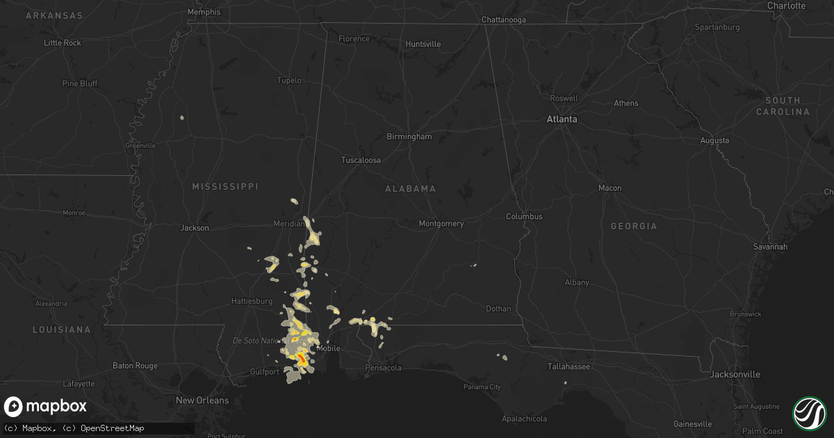
Hail Map in Alabama on May 17, 2018
Get this storm
May 17 map
$229
one time, instant access
Download today. No call, no setup
Keep the $229
Bought the map and want the full workflow? Apply the entire $229 to a subscription within 7 days. None of it is wasted.
Every map, not just this one
This buys you this map. Subscription and you get every map we run, in the markets you choose from a few cities to whole states to nationwide. Plus real-time alerts the moment a storm fires.
Contact data
Name, contact info, occupancy, even credit band for addresses in the footprint. You go from where it hit to who to call.
Become the source they trust
Unlimited branding weather history reports on demand. You already have the documented answer ready for the property owner, and you are the one who showed up with it.
Property data and RoofTrace estimates
Pull up any address you have got, its value and the exact code rules for that jurisdiction, straight from One Click Code. Then RoofTrace estimates the squares, pitch, and roof value, priced the way you price.
Storm reports in Alabama
Alabama
| Date | Description |
|---|---|
| 05/17/20186:24 PM CDT | Trees reported down along county rd 514. |
| 05/17/20186:24 PM CDT | Tree reported down on power lines at hwy 167 and hwy 125. |
| 05/17/20186:20 PM CDT | Several trees down in the town of elba. |
| 05/17/20185:30 PM CDT | Several trees down in the andalusia... Opp... And onycha communities. |
| 05/17/20184:05 PM CDT | Multiple trees down on the road in the pea ridge area. Report via social media. |
| 05/17/20183:55 PM CDT | Sporadic trees down in the pollard community. Pictures and reports via social media. |
| 05/17/20183:30 PM CDT | Metal roof peeled back on an auto repair shop and trees down in atmore. |
| 05/17/20187:56 AM CDT | At 1255 PM CDT, severe thunderstorms were located along a line extending from 8 miles west of Wade to Vancleave, moving east at 5 mph. HAZARD...Golf ball size hail and 60 mph wind gusts. SOURCE...Radar indicated. IMPACT...People and animals outdoors will be injured. Expect hail damage to roofs, siding, windows, and vehicles. Expect wind damage to roofs, siding, and trees. Locations impacted include... Escatawpa, Hurley, Big Point, Vancleave, Wade and Helena. |
| 05/17/20187:42 AM CDT | At 1241 PM CDT, a severe thunderstorm was located 8 miles west of Gilbertown, or 15 miles northeast of Waynesboro, moving east at 20 mph. HAZARD...60 mph wind gusts and quarter size hail. SOURCE...Radar indicated. IMPACT...Hail damage to vehicles is expected. Expect wind damage to roofs, siding, and trees. Locations impacted include... Silas and Gilbertown. |
| 05/17/20182:12 AM CDT | At 711 PM CDT, a severe thunderstorm was located near I10 And I65, or 5 miles south of Downtown Mobile, moving southeast at 30 mph. HAZARD...60 mph wind gusts. SOURCE...Radar indicated. IMPACT...Expect damage to roofs, siding, and trees. Locations impacted include... Downtown Mobile, Daphne, Fairhope, Spanish Fort, Point Clear and I10 And I65. |
| 05/17/20181:47 AM CDT | At 646 PM CDT, a severe thunderstorm was located over Mobile Regional Airport, or 7 miles west of Midtown Mobile, moving southeast at 35 mph. HAZARD...60 mph wind gusts. SOURCE...Radar indicated. IMPACT...Expect damage to roofs, siding, and trees. Locations impacted include... Midtown Mobile, Downtown Mobile, Prichard, Tillmans Corner, Saraland, Theodore, Chickasaw, Satsuma, I65 And I165, Mobile Regional Airport, I65 And AL 158, I10 And I65 and Alabama Port. |
| 05/17/20181:39 AM CDT | At 638 PM CDT, a severe thunderstorm was located near Ozark, moving east at 30 mph. HAZARD...60 mph wind gusts. SOURCE...Radar indicated. IMPACT...Expect damage to roofs, siding, and trees. Locations impacted include... Fort Rucker, Ozark, Ariton, Bells Crossroads, Hunt Field, Dill, Hooper Stage Field, Mabson, Arguta, Snells Crossroads, Ewell, Roeton, Dale County Lake, Marley Hill, Clowers Crossroads, Phillips Crossroads, Hwy 231 Pea River Bridge, Java, Greater Salem Church and Skipperville. |
| 05/17/20181:16 AM CDT | At 616 PM CDT, a severe thunderstorm was located near Fort Rucker, moving east at 30 mph. HAZARD...60 mph wind gusts. SOURCE...Radar indicated. IMPACT...Expect damage to roofs, siding, and trees. Locations impacted include... Daleville, Elba, Enterprise, Fort Rucker, Ozark, Level Plains, New Brockton, Ariton, Clayhatchee, Mixons Crossroads, Hooper Stage Field, Gerald, Central City, Camp Humming Hills, Clintonville, Roeton, Cairns Aaf, Dale County Lake, Camp Alaflo Bsa and Phillips Crossroads. |
| 05/17/201812:52 AM CDT | At 551 PM CDT, a severe thunderstorm was located near Elba, moving east at 30 mph. HAZARD...60 mph wind gusts. SOURCE...Radar indicated. IMPACT...Expect damage to roofs, siding, and trees. Locations impacted include... Elba, Enterprise, Fort Rucker, New Brockton, Lee, Kinston, Mixons Crossroads, Curtis, Carl Folsom A/p, Central City, Camp Humming Hills, Clintonville, Roeton, Camp Alaflo Bsa, Arcus, Enterprise Municipal A/P, Alberton, Richburg, Victoria and Danleys Crossroads. |
| 05/17/201812:36 AM CDT | At 536 PM CDT, a severe thunderstorm was located near Opp, moving east at 30 mph. HAZARD...60 mph wind gusts. SOURCE...Radar indicated. IMPACT...Expect damage to roofs, siding, and trees. Locations impacted include... Elba, Enterprise, New Brockton, Lee, Kinston, Pine Level, Mixons Crossroads, Perry Store, Curtis, Carl Folsom A/p, Lucile, Ino, Turner Crossroads, Lowry Mill, Central City, Camp Humming Hills, Clintonville, Wise Mill, Goodman and Basin. |
| 05/17/201812:10 AM CDT | At 510 PM CDT, a severe thunderstorm was located 8 miles northwest of Leakesville, moving east at 20 mph. HAZARD...60 mph wind gusts. SOURCE...Radar indicated. IMPACT...Expect damage to roofs, siding, and trees. Locations impacted include... Leakesville. |
| 05/16/201810:15 PM CDT | At 315 PM CDT, a severe thunderstorm was located over Poarch Creek Reservation, or 6 miles northwest of Atmore, moving east at 20 mph. HAZARD...60 mph wind gusts and quarter size hail. SOURCE...Radar indicated. IMPACT...Hail damage to vehicles is expected. Expect wind damage to roofs, siding, and trees. Locations impacted include... Atmore, Century, Flomaton, McCullough, I65 And CR 1, I65 And AL 113, I65 And AL 21 and Poarch Creek Reservation. |
| 05/16/20189:42 PM CDT | At 241 PM CDT, a severe thunderstorm was located 6 miles east of Calvert, or 20 miles east of Citronelle, moving east at 10 mph. HAZARD...60 mph wind gusts and quarter size hail. SOURCE...Radar indicated. IMPACT...Hail damage to vehicles is expected. Expect wind damage to roofs, siding, and trees. This severe thunderstorm will remain over mainly rural areas of northeastern Mobile...northwestern Baldwin...southeastern Washington and south central Clarke Counties. |
All States Impacted by Hail Map on May 17, 2018
Cities Impacted by Hail Map on May 17, 2018
- McLaughlin, SD
- Borger, TX
- Dimmitt, TX
- Hart, TX
- Arthur, NE
- Paxton, NE
- Sutherland, NE
- Atmore, AL
- Brewton, AL
- Bullhead, SD
- Heidelberg, MS
- Vossburg, MS
- Shubuta, MS
- Laurel, MS
- Diana, TX
- Whitewood, SD
- Lubbock, TX
- Idalou, TX
- Snyder, TX
- Wilson, TX
- Tahoka, TX
- Slaton, TX
- Colony, OK
- Corn, OK
- Masterson, TX
- Otter, MT
- Olive, MT
- Broadus, MT
- Selby, SD
- Eagle Butte, SD
- Leola, SD
- Eureka, SD
- Hosmer, SD
- Glenham, SD
- Ashley, ND
- Bowdle, SD
- Akaska, SD
- Java, SD
- Mound City, SD
- Long Lake, SD
- Dumas, TX
- Channing, TX
- Winchester, TN
- Estill Springs, TN
- Fort Pierre, SD
- Hayes, SD
- Midland, SD
- Quitman, MS
- Padroni, CO
- Leakesville, MS
- State Line, MS
- Hobbs, NM
- Hedley, TX
- Denver City, TX
- Brownfield, TX
- Jal, NM
- Rayville, MO
- Excelsior Springs, MO
- Sanderson, TX
- Dryden, TX
- Odonnell, TX
- Forgan, OK
- Belle Fourche, SD
- Sidney, NE
- Gurley, NE
- Wilmer, AL
- Paducah, KY
- Skellytown, TX
- Stinnett, TX
- Fritch, TX
- Lemmon, SD
- Pierre, SD
- Justiceburg, TX
- Lucedale, MS
- Grand Bay, AL
- Chunchula, AL
- McLain, MS
- Neely, MS
- Semmes, AL
- Citronelle, AL
- Perkinston, MS
- Moss Point, MS
- Gautier, MS
- Pascagoula, MS
- Mobile, AL
- Eight Mile, AL
- Vancleave, MS
- Circle, MT
- Wolf Point, MT
- Silas, AL
- Beaver, OK
- Laverne, OK
- Auburn, KY
- Russellville, KY
- Edgemont, SD
- Custer, SD
- Olton, TX
- Plainview, TX
- Post, TX
- Bay Minette, AL
- Perdido, AL
- Milton, FL
- Potter, NE
- Vale, SD
- Sturgis, SD
- Butler, AL
- Jachin, AL
- Lisman, AL
- Newcastle, WY
- Hot Springs, SD
- Ellendale, ND
- Caputa, SD
- Adairville, KY
- Dalton, NE
- Bellevue, TX
- Kimball, NE
- Selfridge, ND
- New Underwood, SD
- Union Center, SD
- Buffalo, SD
- Newell, SD
- Meadow, SD
- Sikeston, MO
- Clarendon, TX
- Lakeview, TX
- Paducah, TX
- Kress, TX
- Tulia, TX
- Petersburg, TX
- Abernathy, TX
- Lockney, TX
- Hale Center, TX
- Saint Onge, SD
- Goree, TX
- Fort Stockton, TX
- Ridgeview, SD
- Flomot, TX
- Matador, TX
- Waynesboro, MS
- Floydada, TX
- Hermleigh, TX
- Blunt, SD
- Mud Butte, SD
- Turkey, TX
- Rotan, TX
- Harleton, TX
- McIntosh, AL
- Bighorn, MT
- Fredericktown, MO
- Saint Mary, MO
- Perryville, MO
- Guymon, OK
- Olney, TX
- Millry, AL
- Seymour, TX
- Abilene, TX
- Follett, TX
- Taft, TX
- Faith, SD
- Chadron, NE
- Childress, TX
- Cee Vee, TX
- Anadarko, OK
- Fort Cobb, OK
- Century, FL
- McDavid, FL
- Bison, SD
- Friendship, TN
- Arapaho, OK
- Clinton, OK
- Goldsmith, TX
- Carnegie, OK
- Flomaton, AL
- Levelland, TX
- Keystone, SD
- Hermosa, SD
- Sunray, TX
- Wishek, ND
- Zeeland, ND
- Volborg, MT
- Alliance, NE
- Bowie, TX
- Wakpala, SD
- Sweetwater, TX
- Wolfforth, TX
- Spearfish, SD
- Kaycee, WY
- Custer City, OK
- Oelrichs, SD
- Fredonia, ND
- Harrold, SD
- Melvin, AL
- Gilbertown, AL
- Hysham, MT
- Muenster, TX
- Cyril, OK
- Towner, ND
- Fluvanna, TX
- Buckatunna, MS
- Altha, FL
- Marianna, FL
- Higgins, TX
- Vida, MT
- Farmington, KY
- Sedalia, KY
- Mentone, TX
- Fort Peck, MT
- Alamo, TN
- Trenton, TN
- Quail, TX
- Pelican Rapids, MN
- De Kalb, MS
- Fruitdale, AL
- Chatom, AL
- Foss, OK
- Canute, OK
- Jefferson, TX
- Vinegar Bend, AL
- Ropesville, TX
- Oshkosh, NE
- Custer, MT
- Quitaque, TX
- Fletcher, OK
- Strasburg, ND
- Lakeside, NE
- Grass Range, MT
- Dix, NE
- Lemoyne, NE
- Balko, OK
- Quanah, TX
- Arnett, OK
- Solen, ND
- Hereford, TX
- Roundup, MT
- Musselshell, MT
- Bridgeport, NE
- Hydro, OK
- Jay, FL
- Crawfordville, FL
- Booker, TX
- Timber Lake, SD
- Morristown, SD
- Hershey, NE
- Frankville, AL
- Chaffee, MO
- Knox City, TX
- Graham, TX
- Keystone, NE
- Lauderdale, MS
- Toomsuba, MS
- Cuba, AL
- Meridian, MS
- Henrietta, TX
- Flasher, ND
- Camp Crook, SD
- Black Oak, AR
- Lake City, AR
- Monette, AR
- Meadow, TX
- Aspermont, TX
- Franklin, KY
- Hillsboro, TN
- Trail City, SD
- Murdo, SD
- Linton, ND
- Stapleton, NE
- Collinsville, TX
- Gainesville, TX
- Tell, TX
- Crowell, TX
- Silverton, TX
- Roby, TX
- Saucier, MS
- Canadian, TX
- Wichita Falls, TX
- Gothenburg, NE
- O'Brien, TX
- Wanblee, SD
- Kearney, MO
- Wellfleet, NE
- Gadsden, TN
- Bells, TN
- Scenic, SD
- Lavina, MT
- Gering, NE
- Lexington, NE
- Harrisburg, NE
- Elk City, OK
- Albany, TX
- Richton, MS
- Needham, AL
- Toxey, AL
- Muleshoe, TX
- Anson, TX
- Leroy, AL
- Jacksboro, TX
- McIntosh, SD
- Enning, SD
- Plains, KS
- Gordon, NE
- Rushville, NE
- Whitney, NE
- Claude, TX
- Dupree, SD
- Keldron, SD
- Brady, NE
- Kermit, TX
- Alford, FL
- Shallowater, TX
- Isabel, SD
- Eustis, NE
- Cozad, NE
- Dalhart, TX
- Moorefield, NE
- Maxwell, NE
- Curtis, NE
- Mountain View, OK
- Lewistown, MT
- Hamer, ID
- Bushnell, NE
- Tryon, NE
- Lewisburg, KY
- Hemingford, NE
- Wink, TX
- Mount Vernon, AL
- Little River, AL
- Ellsworth, NE
- Stringer, MS
- Bay Springs, MS
- Diberville, MS
- Minatare, NE
- Chappell, NE
- Sherman, TX
- Paragould, AR
- Bono, AR
- Axis, AL
- Stockton, AL
- Mclean, TX
- Oran, MO
- Lehr, ND
- Hamlin, TX
- Caraway, AR
- Rochester, TX
- Hardesty, OK
- Lodgepole, NE
- Broadwater, NE
- Minter City, MS
- Munday, TX
- Friona, TX
- Maywood, NE
- Hammon, OK
- Batesland, SD
- Overton, NE
- Apache, OK
- Gettysburg, SD
- Lewellen, NE
- Kyle, SD
- Shattuck, OK
- Hazelton, ND
- Troy, AL
- Banks, AL
- Pocatello, ID
- Raleigh, MS
- Louin, MS
- Fort Yates, ND
- Cement, OK
- Chickasha, OK
- Sunset, TX
- Valley View, TX
- Portageville, MO
- Lance Creek, WY
- Daleville, MS
- Notrees, TX
- North Platte, NE
- East Prairie, MO
- Ocean Springs, MS
- Manila, AR
- Merriman, NE
- Hooker, OK
- Plains, TX
- Tokio, TX
- Amarillo, TX
- New Raymer, CO
- Stoneham, CO
- Spring Creek, NV
- Nisland, SD
- Little Eagle, SD
- Richmond, MO
- Lawson, MO
- Hinsdale, MT
- Recluse, WY


