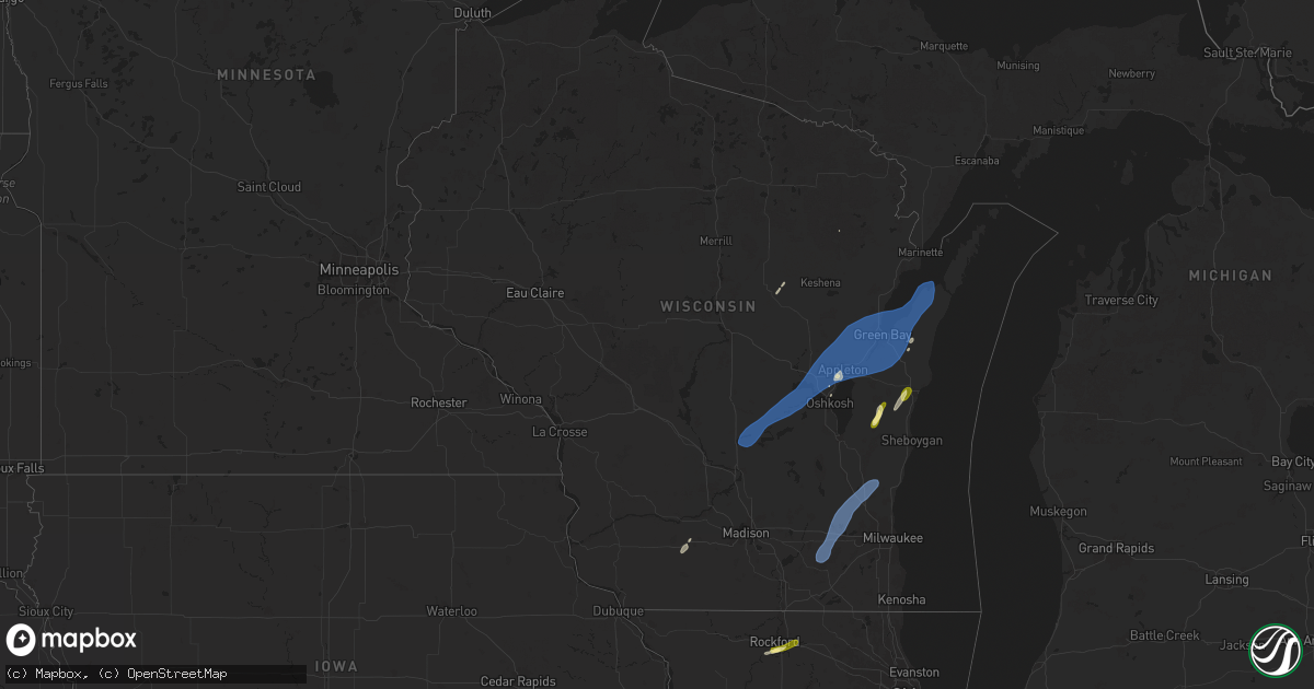
Hail Map in Wisconsin on May 16, 2025
Get this storm
May 16 map
$229
one time, instant access
Download today. No call, no setup
Keep the $229
Bought the map and want the full workflow? Apply the entire $229 to a subscription within 7 days. None of it is wasted.
Every map, not just this one
This buys you this map. Subscription and you get every map we run, in the markets you choose from a few cities to whole states to nationwide. Plus real-time alerts the moment a storm fires.
Contact data
Name, contact info, occupancy, even credit band for addresses in the footprint. You go from where it hit to who to call.
Become the source they trust
Unlimited branding weather history reports on demand. You already have the documented answer ready for the property owner, and you are the one who showed up with it.
Property data and RoofTrace estimates
Pull up any address you have got, its value and the exact code rules for that jurisdiction, straight from One Click Code. Then RoofTrace estimates the squares, pitch, and roof value, priced the way you price.
Storm reports in Wisconsin
Wisconsin
| Date | Description |
|---|---|
| 05/16/20256:12 PM CDT | Winds knocked over part of a tall fence and caused the roof of a barn to collapse. |
| 05/16/20256:07 PM CDT | Trees down. The time of this report is an estimate based on radar. |
| 05/16/20256:00 PM CDT | Trees down. The time of this report is an estimate based on radar. |
| 05/16/20255:57 PM CDT | Snapped trees along ashland avenue near lambeau field. The time of this report is an estimate based on radar data. |
| 05/16/20255:54 PM CDT | A line of storms produced a gust of 50 knots at kgrb. |
| 05/16/20255:33 PM CDT | Trees and power lines down throughout county. The time of this report is an estimate based on radar data. |
| 05/16/20255:22 PM CDT | Strong winds knocked a tree onto a powerline and a trampoline was blown around. |
| 05/16/20255:19 PM CDT | Trees and power lines down. The time of this report is an estimate based on radar. |
| 05/16/20255:14 PM CDT | Trees and power lines down. The time of this report is an estimate based on radar. |
| 05/16/20255:11 PM CDT | Trees and power lines down. The time of this report is an estimate based on radar. |
| 05/16/20255:09 PM CDT | Corrects previous tstm wnd dmg report from 1 sse eureka. Trees and power lines down. The time of this report is an estimate based on radar. |
| 05/16/20254:35 PM CDT | Wisconet site mtlo. |
| 05/16/20253:45 PM CDT | . |
| 05/16/20253:43 PM CDT | Winds flipped over 4 outdoor structures and downed some power lines. Time estimated by radar. |
| 05/16/20253:40 PM CDT | Trees and branches down. |
| 05/16/20253:39 PM CDT | Mesonet site near i-94 and hwy 67 reported a 57 kt/66 mph wind gust. |
| 05/16/20253:20 PM CDT | Large tree down along blue spring lake. |
All States Impacted by Hail Map on May 16, 2025
Cities Impacted by Hail Map on May 16, 2025
- Cash, AR
- Harned, KY
- Garfield, KY
- Newport, AR
- Vevay, IN
- Greenville, KY
- White Plains, KY
- Berea, KY
- Mount Vernon, KY
- Fairmount City, PA
- Mayport, PA
- Kennett, MO
- Hornersville, MO
- Princeton, KY
- Portageville, MO
- Hayti, MO
- McKee, KY
- Tiptonville, TN
- Bragg City, MO
- Custer, KY
- Irvington, KY
- Vine Grove, KY
- Warsaw, KY
- Ghent, KY
- Holcomb, MO
- Springfield, KY
- Willisburg, KY
- Gobler, MO
- Steele, MO
- Madisonville, KY
- Hickman, KY
- East Prairie, MO
- Eddyville, KY
- Cadiz, KY
- Union City, TN
- Jonesboro, AR
- Caruthersville, MO
- Arbyrd, MO
- Cerulean, KY
- Weiner, AR
- Harrisburg, AR
- Rineyville, KY
- Radcliff, KY
- Ridgely, TN
- Clinton, KY
- Crofton, KY
- Nortonville, KY
- Powderly, KY
- Central City, KY
- Paint Lick, KY
- Elizabethtown, KY
- West Point, KY
- Lebanon Junction, KY
- Lake City, AR
- Hornbeak, TN
- Hickory, KY
- Troy, TN
- Fulton, KY
- Fancy Farm, KY
- Mayfield, KY
- Rochester, KY
- Morgantown, KY
- Beechmont, KY
- Drakesboro, KY
- Beech Creek, KY
- Browder, KY
- Boston, KY
- Elkton, KY
- Hopkinsville, KY
- Belton, KY
- Lewisburg, KY
- Cecilia, KY
- Fort Knox, KY
- Bay, AR
- Monette, AR
- South Fulton, TN
- Water Valley, KY
- Wingo, KY
- Dunmor, KY
- Campbellsville, KY
- Black Oak, AR
- Benton, KY
- Shepherdsville, KY
- Leachville, AR
- Coxs Creek, KY
- Manila, AR
- Caraway, AR
- Bardstown, KY
- Obion, TN
- Thida, AR
- Bradford, AR
- Oil Trough, AR
- Tuckerman, AR
- Amagon, AR
- Fisher, AR
- Pleasant Plains, AR
- Trumann, AR
- Etowah, AR
- Sedalia, KY
- Bowling Green, KY
- Bloomfield, KY
- Clarkson, KY
- Columbia, KY
- Hazel, KY
- Murray, KY
- Farmington, KY
- Millwood, KY
- Trenton, KY
- Pembroke, KY
- Martin, TN
- Blytheville, AR
- Elk Horn, KY
- Chaplin, KY
- Rockfield, KY
- Jetson, KY
- Kirksey, KY
- Symsonia, KY
- Liberty, KY
- Hardin, KY
- Guthrie, KY
- Gilbertsville, KY
- Kuttawa, KY
- Almo, KY
- Beaver Dam, KY
- Eubank, KY
- Crab Orchard, KY
- Marston, MO
- Hustonville, KY
- Lawrenceburg, KY
- Bee Spring, KY
- Sweeden, KY
- Brownsville, KY
- Mount Eden, KY
- Oakland, KY
- Smiths Grove, KY
- Hodgenville, KY
- Dexter, KY
- Dresden, TN
- Palmersville, TN
- Dukedom, TN
- Finley, TN
- Roundhill, KY
- Livingston, KY
- Newbern, TN
- New Haven, KY
- Rives, TN
- Yosemite, KY
- Versailles, KY
- East Bernstadt, KY
- Russellville, KY
- Annville, KY
- Sharon, TN
- Bonnieville, KY
- Upton, KY
- Sonora, KY
- Munfordville, KY
- Magnolia, KY
- Park City, KY
- Rocky Hill, KY
- Cave City, KY
- Kings Mountain, KY
- Stanford, KY
- Middleburg, KY
- Waynesburg, KY
- Puryear, TN
- Cottage Grove, TN
- Tyner, KY
- Gracey, KY
- Herndon, KY
- Mount Sherman, KY
- Harrodsburg, KY
- Greensburg, KY
- Canmer, KY
- Summersville, KY
- New Concord, KY
- Salvisa, KY
- Buffalo, KY
- Paris, TN
- Sandgap, KY
- Orlando, KY
- Vincent, KY
- Booneville, KY
- Horse Cave, KY
- Hardyville, KY
- Sharon Grove, KY
- Buchanan, TN
- Lebanon, KY
- Sextons Creek, KY
- Buckhorn, KY
- Ricetown, KY
- Mistletoe, KY
- Jackson, KY
- Bradfordsville, KY
- Gravel Switch, KY
- Dover, TN
- Auburn, KY
- Manchester, KY
- Whick, KY
- Lost Creek, KY
- Clayhole, KY
- Rowdy, KY
- Woodburn, KY
- Big Sandy, TN
- Richmond, KY
- Dunnville, KY
- Clarksville, TN
- Woodlawn, TN
- Knifley, KY
- Leitchfield, KY
- Mammoth Cave, KY
- Olmstead, KY
- Allensville, KY
- Somerset, KY
- Oak Grove, KY
- Adams, TN
- Cedar Hill, TN
- Springfield, TN
- Glasgow, KY
- Hueysville, KY
- Adairville, KY
- Franklin, KY
- Alvaton, KY
- Brodhead, KY
- Edmonton, KY
- Scottsville, KY
- Portland, TN
- Orlinda, TN
- Leburn, KY
- Vest, KY
- Gunlock, KY
- Cross Plains, TN
- Beattyville, KY
- Vancleve, KY
- Austin, KY
- Lucas, KY
- Adolphus, KY
- Westmoreland, TN
- Center, KY
- Cottontown, TN
- Glens Fork, KY
- White House, TN
- Salem, NJ
- Rousseau, KY
- Summer Shade, KY
- Jenkins, KY
- Neon, KY
- McRoberts, KY
- Jackhorn, KY
- Lafayette, TN
- Oneida, KY
- Gays Creek, KY
- Fountain Run, KY
- Salyersville, KY
- Windsor, KY
- Virgie, KY
- Robinson Creek, KY
- Knob Lick, KY
- Mount Hermon, KY
- Bethpage, TN
- Tompkinsville, KY
- Holland, KY
- Etoile, KY
- Shiloh, NJ
- Bridgeton, NJ
- Gamaliel, KY
- Bulan, KY
- Russell Springs, KY
- Burkesville, KY
- Garrett, KY
- Jamestown, KY
- Hazard, KY
- Ashcamp, KY
- Emmalena, KY
- Chavies, KY
- Ary, KY
- Mousie, KY
- Pikeville, KY
- Shelbiana, KY
- Wayland, KY
- Raven, KY
- Garner, KY
- Hi Hat, KY
- Dema, KY
- McDowell, KY
- Ozark, AR
- Altus, AR
- Lackey, KY
- Minnie, KY
- Printer, KY
- Grethel, KY
- Harold, KY
- Albany, KY
- Science Hill, KY
- Beaver, KY
- Rector, AR
- Marmaduke, AR
- Nancy, KY
- Kite, KY
- Langley, KY
- Wheelwright, KY
- Topmost, KY
- Bypro, KY
- Prestonsburg, KY
- Melvin, KY
- Drift, KY
- Bevinsville, KY
- Hindman, KY
- Pippa Passes, KY
- Clarksville, AR
- Coal Hill, AR
- Hartman, AR
- Teaberry, KY
- Elkhorn City, KY
- Regina, KY
- Belcher, KY
- Hellier, KY
- Millville, NJ
- Ferguson, KY
- London, KY
- Monticello, KY
- Weeksbury, KY
- Mouthcard, KY
- Lick Creek, KY
- Lamar, AR
- Hagarville, AR
- Springfield, MO
- Alpha, KY
- Burnside, KY
- Krypton, KY
- Shelby Gap, KY
- Strafford, MO
- Marshfield, MO
- Dover, AR
- Pelsor, AR
- Niangua, MO
- Parkers Lake, KY
- Grundy, VA
- Big Rock, VA
- Garrison, MO
- Taneyville, MO
- Corbin, KY
- Keavy, KY
- Whitley City, KY
- Breaks, VA
- Phyllis, KY
- Ava, MO
- Chadwick, MO
- Oldfield, MO
- Lebanon, MO
- Mansfield, MO
- Norwood, MO
- Macomb, MO
- Mountain Grove, MO
- Oakwood, VA
- Pilgrims Knob, VA
- Seymour, MO
- Lily, KY
- Sizerock, KY
- Hyden, KY
- Bear Branch, KY
- Vansant, VA
- Haysi, VA
- Jolo, WV
- Iaeger, WV
- Eastern, KY
- Big Creek, KY
- Hector, AR
- Squires, MO
- Richland, MO
- Grovespring, MO
- Falcon, MO
- Cabool, MO
- Drury, MO
- Vanzant, MO
- Laquey, MO
- Busy, KY
- Wooton, KY
- Georgetown, DE
- Bonnyman, KY
- Thousandsticks, KY
- Forsyth, MO
- Hartville, MO
- Jerusalem, AR
- Cub Run, KY
- Cape May Court House, NJ
- Gray, KY
- Cannon, KY
- Heidrick, KY
- Barbourville, KY
- Jewell Ridge, VA
- Whitewood, VA
- Raysal, WV
- Berwind, WV
- Raven, VA
- Woodbine, KY
- Bimble, KY
- Paynesville, WV
- War, WV
- Rockholds, KY
- Bandy, VA
- Combs, KY
- Squire, WV
- Smilax, KY
- Guston, KY
- Scotland, AR
- Fort Leonard Wood, MO
- Waynesville, MO
- Saint Robert, MO
- Graff, MO
- Plato, MO
- Huggins, MO
- Roby, MO
- Licking, MO
- Lynchburg, MO
- Delmont, NJ
- Woodbine, NJ
- Hinkle, KY
- Walker, KY
- Flat Lick, KY
- Girdler, KY
- Scalf, KY
- Stone Harbor, NJ
- Millsboro, DE
- Redfox, KY
- Whitesburg, KY
- Viper, KY
- Jeff, KY
- Mallie, KY
- Pine Top, KY
- Happy, KY
- Blackey, KY
- Cornettsville, KY
- Vicco, KY
- Clinton, AR
- Avalon, NJ
- Sassafras, KY
- Scuddy, KY
- Hallie, KY
- Willow Springs, MO
- Devils Elbow, MO
- Dixon, MO
- Sea Isle City, NJ
- Newburg, MO
- Elk Creek, MO
- Solo, MO
- Wildwood, NJ
- Jerome, MO
- Dagsboro, DE
- Rolla, MO
- Houston, MO
- Yukon, MO
- Summersville, MO
- Eunice, MO
- Hermann, MO
- Berger, MO
- Fallentimber, PA
- Rocky Gap, VA
- Bastian, VA
- Narrows, VA
- Ocean City, NJ
- Williamsburg, MO
- Kingdom City, MO
- Fulton, MO
- Auxvasse, MO
- Bledsoe, KY
- Baxter, KY
- Eolia, KY
- Martinsburg, MO
- Benton City, MO
- Wellsville, MO
- Montgomery City, MO
- Success, MO
- Bucyrus, MO
- Bluefield, VA
- Bluefield, WV
- Falls Mills, VA
- Leesburg, NJ
- Duke, MO
- Jeremiah, KY
- Partridge, KY
- Millstone, KY
- Mayking, KY
- Ermine, KY
- Roxana, KY
- Premium, KY
- Linefork, KY
- Isom, KY
- Thornton, KY
- Letcher, KY
- Shirley, AR
- Fairfield Bay, AR
- Mountain View, MO
- Middletown, MO
- Bellflower, MO
- Bland, VA
- Belle, MO
- Frankford, DE
- New Haven, MO
- Pound, VA
- Appalachia, VA
- Wise, VA
- Crocker, MO
- Owensville, MO
- Gerald, MO
- Gassville, AR
- Cotter, AR
- Marthasville, MO
- Bland, MO
- Eminence, MO
- Hartshorn, MO
- Washington, MO
- Rosebud, MO
- Birch Tree, MO
- Leslie, MO
- Beaufort, MO
- Union, MO
- Leasburg, MO
- Cuba, MO
- Steelville, MO
- Mountain Home, AR
- Eolia, MO
- Augusta, MO
- Warriors Mark, PA
- Castlewood, VA
- Dante, VA
- Nora, VA
- Saint Paul, VA
- Coeburn, VA
- Gamaliel, AR
- Silex, MO
- Bowling Green, MO
- Henderson, AR
- Staffordsville, VA
- Pearisburg, VA
- Truxton, MO
- High Hill, MO
- Tyrone, PA
- Saint James, MO
- Selbyville, DE
- Milton, DE
- Lewes, DE
- Defiance, MO
- Foristell, MO
- Clarkridge, AR
- Caulfield, MO
- Bakersfield, MO
- Gepp, AR
- Moody, MO
- Wentzville, MO
- Winona, MO
- O'Fallon, MO
- Saint Charles, MO
- West Plains, MO
- Denmark, WI
- Mineral Point, MO
- Potosi, MO
- Spruce Creek, PA
- Pennsylvania Furnace, PA
- Varney, KY
- Tigerton, WI
- Wittenberg, WI
- Troy, MO
- Elsberry, MO
- Port Matilda, PA
- Chesterfield, MO
- Bishopville, MD
- Fedscreek, KY
- Kimper, KY
- Steele, KY
- Pulaski, VA
- Dublin, VA
- Radford, VA
- State College, PA
- Hurley, VA
- Mohawk, WV
- Cleveland, VA
- Bradleyville, MO
- Tazewell, VA
- Tannersville, VA
- Ozone, AR
- Phelps, KY
- Raccoon, KY
- Lebanon, VA
- Bays, KY
- Clarksville, MO
- Bourbon, MO
- Christiansburg, VA
- Pilot, VA
- Riner, VA
- Floyd, VA
- Check, VA
- Blacksburg, VA
- Van Buren, MO
- Fremont, MO
- Belspring, VA
- Newport, VA
- Eggleston, VA
- Pembroke, VA
- Parrott, VA
- Elliston, VA
- Shawsville, VA
- Saint Peters, MO
- Wildwood, MO
- Batchtown, IL
- Hamburg, IL
- Hardin, IL
- Ballwin, MO
- Saint Louis, MO
- Maryland Heights, MO
- Earth City, MO
- Ellington, MO
- Brussels, IL
- Golden Eagle, IL
- Petersburg, PA
- Luxemburg, WI
- Saltville, VA
- Ceres, VA
- Huntingdon, PA
- Ocean City, MD
- Bonne Terre, MO
- Old Monroe, MO
- Moscow Mills, MO
- Bowler, WI
- Winfield, MO
- Foley, MO
- Dora, MO
- Harpers Ferry, WV
- Round Hill, VA
- Broadford, VA
- Saint Albans, MO
- Labadie, MO
- Sullivan, MO
- Bridgeton, MO
- Saint Ann, MO
- Hazelwood, MO
- Florissant, MO
- Fieldon, IL
- Kane, IL
- Jerseyville, IL
- Belleville, PA
- Rockbridge, IL
- Redford, MO
- Purcellville, VA
- Copper Hill, VA
- Greenfield, IL
- Carrollton, IL
- Chesterfield, IL
- Ellsinore, MO
- Chilhowie, VA
- Meadowview, VA
- Marion, VA
- Glade Spring, VA
- Edgar Springs, MO
- Pomona, MO
- Callaway, VA
- Oldtown, MD
- Bloomsdale, MO
- Prairie Du Rocher, IL
- Festus, MO
- Fults, IL
- Lewistown, PA
- Piedmont, MO
- Mill Spring, MO
- Lesterville, MO
- Venice, IL
- Granite City, IL
- Madison, IL
- Vulcan, MO
- Annapolis, MO
- Des Arc, MO
- Lovejoy, IL
- East Saint Louis, IL
- Red Bud, IL
- McVeytown, PA
- Rocky Mount, VA
- Grafton, IL
- Mountain, WI
- Ellenburg Depot, NY
- Altona, NY
- Mooers Forks, NY
- Fidelity, IL
- Medora, IL
- Wytheville, VA
- Hettick, IL
- Palmyra, IL
- Flintstone, MD
- Little Orleans, MD
- Boones Mill, VA
- Waterloo, IL
- Waterford, VA
- Leesburg, VA
- Williamsville, MO
- Greenville, MO
- Villa Ridge, MO
- Wiley Ford, WV
- Cumberland, MD
- Frostburg, MD
- Lonaconing, MD
- Ridgeley, WV
- Rawlings, MD
- Great Cacapon, WV
- Waverly, IL
- Virden, IL
- Edwardsville, IL
- Collinsville, IL
- Glen Carbon, IL
- Loami, IL
- Chatham, IL
- Auburn, IL
- New Berlin, IL
- Springfield, IL
- New Athens, IL
- Lenzburg, IL
- Marissa, IL
- Rochester, IL
- Riverton, IL
- Dickerson, MD
- Laurel, DE
- Max Meadows, VA
- Ivanhoe, VA
- Austinville, VA
- Baldwin, IL
- Carlinville, IL
- Wappapello, MO
- Carlyle, IL
- Fredericktown, MO
- Appomattox, VA
- Irvine, KY
- Shipman, IL
- Granville, PA
- Glade Hill, VA
- Pacific, MO
- Salem, MO
- Girard, IL
- Gillespie, IL
- Litchfield, IL
- McGee, MO
- Nilwood, IL
- Waggoner, IL
- Raymond, IL
- Marquand, MO
- Dawson, IL
- Sherman, IL
- Williamsville, IL
- Buffalo, IL
- Mifflin, PA
- Farmersville, IL
- Silva, MO
- Patterson, MO
- Port Royal, PA
- Nashville, IL
- Poolesville, MD
- Martinsville, VA
- Keyesport, IL
- Greenville, IL
- Cadet, MO
- Dodgeville, WI
- Mineral Point, WI
- Cantrall, IL
- Lovettsville, VA
- Centerville, MO
- Bunker, MO
- Farmville, VA
- Coulterville, IL
- Oakdale, IL
- Germantown, MD
- Potomac, MD
- Clarksburg, MD
- Kiel, WI
- Newton, WI
- Valders, WI
- Gretna, VA
- Cherryville, MO
- Davisville, MO
- Okawville, IL
- Millville, WV
- Charles Town, WV
- Manitowoc, WI
- Reedsville, WI
- Advance, MO
- Zalma, MO
- Sturdivant, MO
- Lowndes, MO
- Gipsy, MO
- Puxico, MO
- Brownwood, MO
- Millerstown, PA
- Ickesburg, PA
- Bloomfield, MO
- Patton, MO
- Martinsburg, WV
- Hedgesville, WV
- Gerrardstown, WV
- Inwood, WV
- Kearneysville, WV
- Shepherdstown, WV
- Sharpsburg, MD
- Shenandoah Junction, WV
- Pleasant Plains, IL
- Barneveld, WI
- Callands, VA
- Axton, VA
- Black, MO
- Modesto, IL
- Ranson, WV
- Gaithersburg, MD
- Rockville, MD
- Park Hills, MO
- Collinsville, VA
- Fieldale, VA
- Addieville, IL
- Marble Hill, MO
- Berryville, VA
- Ridgeway, WI
- Pawnee, IL
- Damascus, MD
- Patrick Springs, VA
- Stuart, VA
- Columbia, IL
- Harvel, IL
- Morrisonville, IL
- Mount Pulaski, IL
- Bluemont, VA
- Elkhart, IL
- Middleburg, VA
- Hamilton, VA
- Oran, MO
- Bell City, MO
- Benton, MO
- Palmyra, WI
- Whitewater, WI
- Fort Atkinson, WI
- Jefferson, WI
- Helenville, WI
- Sullivan, WI
- Dousman, WI
- Oconomowoc, WI
- Delafield, WI
- Nashotah, WI
- Okauchee, WI
- Hartland, WI
- Rubicon, WI
- Hartford, WI
- Colgate, WI
- Slinger, WI
- Hubertus, WI
- Richfield, WI
- Newport, PA
- Myersville, MD
- Frederick, MD
- Middletown, MD
- Jefferson, MD
- Richview, IL
- Glenallen, MO
- East Carondelet, IL
- Chatham, VA
- Shobonier, IL
- Mechanicsburg, IL
- Edinburg, IL
- Dry Fork, VA
- Blairs, VA
- Frenchville, PA
- Burfordville, MO
- Nathalie, VA
- Upperville, VA
- Belgrade, MO
- De Soto, MO
- Blackwell, MO
- Divernon, IL
- Bassett, VA
- Critz, VA
- Westminster, MD
- Taneytown, MD
- Dupo, IL
- Littlestown, PA
- Paeonian Springs, VA
- Bethesda, MD
- Knoxville, MD
- Tuscarora, MD
- Point Of Rocks, MD
- Adamstown, MD
- Brunswick, MD
- Rohrersville, MD
- Burkittsville, MD
- Phenix, VA
- Brookneal, VA
- Farmington, MO
- Valles Mines, MO
- French Village, MO
- Sainte Genevieve, MO
- Modoc, IL
- Ellis Grove, IL
- Clearfield, PA
- Sikeston, MO
- Charleston, MO
- Scott City, MO
- Mounds, IL
- Cairo, IL
- Miller City, IL
- Millersville, MO
- New Bloomfield, PA
- Jackson, MO
- Whitewater, MO
- Mount Auburn, IL
- Ingraham, IL
- Newton, IL
- Finksburg, MD
- Breese, IL
- Aviston, IL
- Keeling, VA
- Wheeler, IL
- Red Oak, VA
- Hanover, PA
- Skipwith, VA
- Scottsburg, VA
- Bowie, MD
- Hampstead, MD
- Irondale, MO
- Bixby, MO
- Belleview, MO
- Boss, MO
- Annandale, VA
- Danville, VA
- Ringgold, VA
- Glenarm, IL
- Centralia, IL
- Walnut Hill, IL
- Gettysburg, PA
- Boyds, MD
- Chase City, VA
- Clover, VA
- Saxe, VA
- Drakes Branch, VA
- Randolph, VA
- Vernon Hill, VA
- Beallsville, MD
- Union Bridge, MD
- New Windsor, MD
- Percy, IL
- Shermans Dale, PA
- Duncannon, PA
- Upperco, MD
- Kell, IL
- Salem, IL
- Hoyleton, IL
- Irvington, IL
- Walkersville, MD
- Thurmont, MD
- Farina, IL
- Mason, IL
- Louisville, IL
- Dieterich, IL
- Keymar, MD
- Woodsboro, MD
- Sutherlin, VA
- South Boston, VA
- Mount Airy, MD
- Fairfax Station, VA
- Evansville, IL
- Oak Ridge, MO
- Mifflintown, PA
- Biglerville, PA
- Aspers, PA
- Barlow, KY
- Ijamsville, MD
- Java, VA
- Upper Marlboro, MD
- Harwood, MD
- Edgewater, MD
- Davidsonville, MD
- Villa Ridge, IL
- Tamms, IL
- Perryville, MO
- Barnesville, MD
- Steeleville, IL
- Chester, IL
- Halifax, VA
- West Bend, WI
- Jackson, WI
- Saukville, WI
- Mound City, IL
- West Liberty, IL
- Willow Hill, IL
- Sainte Marie, IL
- Oblong, IL
- Elkhart Lake, WI
- New Holstein, WI
- Manchester, MD
- Caledonia, MO
- Bismarck, MO
- Sparks Glencoe, MD
- Reisterstown, MD
- Cockeysville, MD
- Boydton, VA
- Alexandria, VA
- Fort Belvoir, VA
- Lorton, VA
- Springfield, VA
- Fort Washington, MD
- Kenbridge, VA
- Victoria, VA
- Henry, VA
- La Center, KY
- Annapolis, MD
- Wickliffe, KY
- Buffalo Junction, VA
- Kevil, KY
- Stevensville, MD
- Fort Myer, VA
- Falls Church, VA
- Arlington, VA
- Clinton, MD
- Brandywine, MD
- Accokeek, MD
- Oxon Hill, MD
- Washington, DC
- Naval Anacost Annex, DC
- Temple Hills, MD
- Andrews Air Force Base, MD
- Cheltenham, MD
- District Heights, MD
- Capitol Heights, MD
- Suitland, MD
- Ashburn, VA
- Sterling, VA
- Derwood, MD
- Washington Grove, MD
- Montgomery Village, MD
- Fulton, MD
- Brookeville, MD
- Sandy Spring, MD
- Ashton, MD
- Highland, MD
- Olney, MD
- Spencer, VA
- Laurel, MD
- Annapolis Junction, MD
- Jessup, MD
- Brinklow, MD
- Savage, MD
- Clarksville, MD
- Columbia, MD
- Elkridge, MD
- Severn, MD
- Glen Burnie, MD
- Harmans, MD
- Hanover, MD
- Ellicott City, MD
- Baltimore, MD
- Catonsville, MD
- Halethorpe, MD
- Dundalk, MD
- Hyattsville, MD
- Mount Rainier, MD
- Bladensburg, MD
- Brentwood, MD
- Robinson, IL
- Saint Michaels, MD
- Claiborne, MD
- Mcdaniel, MD
- Doe Run, MO
- Baskerville, VA
- South Hill, VA
- Sumner, IL
- Parkton, MD
- Paducah, KY
- West Paducah, KY
- Stoy, IL
- Wittman, MD
- Greenbelt, MD
- Riva, MD
- Lanham, MD
- Mason, TX
- Chevy Chase, MD
- Kensington, MD
- Takoma Park, MD
- Burke, VA
- Fairfax, VA
- Silver Spring, MD
- Mechanicsville, MD
- Chaptico, MD
- Hughesville, MD
- Charlotte Hall, MD
- Clifton, VA
- Woodbridge, VA
- Sparta, IL
- La Crosse, VA
- Brodnax, VA
- Montello, WI
- Neshkoro, WI
- Princeton, WI
- Redgranite, WI
- Berlin, WI
- Omro, WI
- Green Lake, WI
- Winneconne, WI
- Brookport, IL
- Metropolis, IL
- Keysville, VA
- Lunenburg, VA
- Dundas, VA
- Alberta, VA
- Dolphin, VA
- Warfield, VA
- Rawlings, VA
- Blackstone, VA
- Lawrenceville, VA
- McKenney, VA
- Freeman, VA
- Jarratt, VA
- Stony Creek, VA
- Hutsonville, IL
- Palestine, IL
- Merom, IN
- Sullivan, IN
- Saint Mary, MO
- Koshkonong, MO
- Dayton, MD
- Linthicum Heights, MD
- Pasadena, MD
- Curtis Bay, MD
- Gambrills, MD
- Millersville, MD
- Fort George G Meade, MD
- Odenton, MD
- Leonardtown, MD
- Kinsman, OH
- Llano, TX
- Castell, TX
- Owings, MD
- Saint Leonard, MD
- Lusby, MD
- Sparrows Point, MD
- Ledbetter, KY
- Easton, MD
- Saint Clair, MO
- Benedict, MD
- Prince Frederick, MD
- Aquasco, MD
- Fairbanks, IN
- Annapolis, IL
- Spencerville, MD
- Burtonsville, MD
- Loveville, MD
- Bracey, VA
- Warrenton, NC
- Hollywood, MD
- Clements, MD
- Dunkirk, MD
- Lothian, MD
- Edgewood, MD
- Montross, VA
- Hague, VA
- Fort Howard, MD
- Callaway, MD
- Port Republic, MD
- California, MD
- Severna Park, MD
- Beltsville, MD
- Crownsville, MD
- Arnold, MD
- Gibson Island, MD
- Gwynn Oak, MD
- Thayer, MO
- Brooklyn, MD
- Essex, MD
- Alton, MO
- Church Creek, MD
- Fishing Creek, MD
- Golconda, IL
- Smithland, KY
- Burna, KY
- Calvert City, KY
- Tiline, KY
- Grand Rivers, KY
- Friendship, MD
- Tracys Landing, MD
- Deale, MD
- West River, MD
- Galesville, MD
- Shady Side, MD
- Churchton, MD
- Monkton, MD
- Phoenix, MD
- Federalsburg, MD
- Preston, MD
- Aberdeen Proving Ground, MD
- Landisburg, PA
- Neenah, WI
- Patuxent River, MD
- Lexington Park, MD
- Exmore, VA
- Jamestown, PA
- Brownstown, IL
- Vandalia, IL
- West York, IL
- Couch, MO
- Littleton, NC
- Ebony, VA
- Macon, NC
- Huntingtown, MD
- Sunderland, MD
- Saint Peter, IL
- Great Mills, MD
- Henrico, NC
- Gasburg, VA
- White Plains, VA
- Valley Lee, MD
- Dowell, MD
- Broomes Island, MD
- Park Hall, MD
- Solomons, MD
- Rock Hall, MD
- Trilla, IL
- Mattoon, IL
- Chesapeake Beach, MD
- Franktown, VA
- Salem, AR
- Machipongo, VA
- Birdsnest, VA
- East Alton, IL
- Alton, VA
- Rockwood, IL
- Dugger, IN
- Shelburn, IN
- Jasonville, IN
- Linton, IN
- Carlisle, IN
- Appleton, WI
- Kaukauna, WI
- Greenville, WI
- Oneida, WI
- Green Bay, WI
- Larsen, WI
- Hortonville, WI
- Oshkosh, WI
- Black Creek, WI
- Seymour, WI
- De Pere, WI
- Fremont, WI
- Shiocton, WI
- Pulaski, WI
- Little Chute, WI
- Butte Des Morts, WI
- Menasha, WI
- Ripon, WI
- Clayton, IN
- Stilesville, IN
- Clubb, MO
- Crapo, MD
- Toddville, MD
- Wingate, MD
- Worthington, IN
- Granbury, TX
- Roanoke Rapids, NC
- Gaston, NC
- Charleston, IL
- Lerna, IL
- Jacob, IL
- Altamont, IL
- Saint Elmo, IL
- Beecher City, IL
- Trappe, MD
- Watson, IL
- Effingham, IL
- Frohna, MO
- Marion, KY
- Coal City, IN
- Coatesville, IN
- Cloverdale, IN
- Fillmore, IN
- Greencastle, IN
- Camp, AR
- Shumway, IL
- Tilghman, MD
- Neavitt, MD
- Bozman, MD
- Royal Oak, MD
- Farmersburg, IN
- Lewis, IN
- Pimento, IN
- Hurlock, MD
- Fredonia, KY
- Ava, IL
- Gorham, IL
- Murphysboro, IL
- Clay City, IN
- Bloomfield, IN
- Switz City, IN
- Sherwood, MD
- Queenstown, MD
- Teutopolis, IL
- Ashmore, IL
- Cordova, MD
- Cherokee, TX
- Montrose, IL
- San Saba, TX
- Danville, IN
- Amo, IN
- Plainfield, IN
- Avon, IN
- Indianapolis, IN
- Mooresville, IN
- Camby, IN
- Monrovia, IN
- Martinsville, IN
- Quincy, IN
- Greenwood, IN
- West Newton, IN
- Beech Grove, IN
- Dawson Springs, KY
- Mammoth Spring, AR
- Denton, MD
- Toledo, IL
- Neoga, IL
- Hebron, MD
- Oxford, MD
- Sobieski, WI
- Suamico, WI
- Little Suamico, WI
- Oconto, WI
- Abrams, WI
- Vienna, MD
- Cambridge, MD
- Doniphan, MO
- Cresson, TX
- Quantico, MD
- Tyaskin, MD
- Tow, TX
- Sigel, IL
- New Franken, WI
- Westover, MD
- Viola, AR
- Bexar, AR
- Jewett, IL
- Rhodesdale, MD
- De Soto, IL
- Elkville, IL
- Carterville, IL
- Hurst, IL
- Cambria, IL
- Herrin, IL
- Carbondale, IL
- Mardela Springs, MD
- Paris, IL
- Jonesboro, IL
- Cobden, IL
- Alto Pass, IL
- Leopold, MO
- Pinckneyville, IL
- Godley, TX
- Ravenden, AR
- Raleigh, IL
- Broughton, IL
- Freedom, IN
- Lodi, MO
- Seymour, IN
- Columbus, IN
- Grandin, MO
- Sharptown, MD
- Fort Worth, TX
- Buchanan Dam, TX
- Bargersville, IN
- Royalton, IL
- Marion, IL
- Energy, IL
- Mitchell, IN
- Bedford, IN
- Hardinsburg, KY
- Galatia, IL
- Eldorado, IL
- East New Market, MD
- Linkwood, MD
- Salisbury, MD
- Seaford, DE
- Delmar, DE
- Parsonsburg, MD
- Bethel, DE
- Delmar, MD
- Haltom City, TX
- Campbell Hill, IL
- Edgewood, IL
- Spencer, IN
- Solsberry, IN
- Valley Spring, TX
- Franklin, IN
- Whiteland, IN
- Joshua, TX
- Needham, IN
- New Palestine, IN
- Greenfield, IN
- Mccordsville, IN
- Fortville, IN
- Charlottesville, IN
- Maxwell, IN
- Pendleton, IN
- Makanda, IL
- Burnet, TX
- Crowley, TX
- Gosport, IN
- Bloomington, IN
- Ellettsville, IN
- Lometa, TX
- Bend, TX
- Lampasas, TX
- Greenup, IL
- Martinsville, IL
- Casey, IL
- Warm Springs, AR
- Pocahontas, AR
- Myrtle, MO
- Norman, IN
- Kansas, IL
- Fairdealing, MO
- Harviell, MO
- Poplar Bluff, MO
- Norris City, IL
- Medora, IN
- Vallonia, IN
- Brownstown, IN
- Elizabethtown, IN
- Heltonville, IN
- Westport, IN
- Hartsville, IN
- Johnston City, IL
- Farrar, MO
- Ekron, KY
- Clinton, IN
- West Terre Haute, IN
- Freeman Spur, IL
- West Frankfort, IL
- Pittsburg, IL
- Universal, IN
- Vermilion, IL
- Burleson, TX
- Creal Springs, IL
- Chaffee, MO
- Ravenden Springs, AR
- Hardy, AR
- Glencoe, AR
- Cape Girardeau, MO
- Saint Charles, KY
- Hidalgo, IL
- Westfield, IL
- Rosedale, IN
- Rockville, IN
- Chestertown, MD
- Peshtigo, WI
- Marinette, WI
- Casco, WI
- Brussels, WI
- Sturgeon Bay, WI
- Forestville, WI
- Worton, MD
- Nashville, IN
- Freetown, IN
- Centreville, MD
- Nineveh, IN
- Barclay, MD
- Church Hill, MD
- Sudlersville, MD
- Grammer, IN
- Greensburg, IN
- Gatewood, MO
- Edinburgh, IN
- Maynard, AR
- Ingleside, MD
- Marydel, MD
- Henderson, MD
- Hartly, DE
- Marydel, DE
- Goldsboro, MD
- Camden Wyoming, DE
- Felton, DE
- Ellendale, DE
- Fairland, IN
- Boggstown, IN
- New Goshen, IN
- Terre Haute, IN
- Carmi, IL
- Williford, AR
- Pomona, IL
- Broseley, MO
- Thompsonville, IL
- Harrisburg, IL
- Carrier Mills, IL
- Wolf Lake, IL
- Grand Tower, IL
- North Vernon, IN
- Paragon, IN
- Trenton, IL
- Avenue, MD
- Fisk, MO
- Thebes, IL
- Carmel, IN
- Cicero, IN
- Westfield, IN
- Noblesville, IN
- Fishers, IN
- Ridge, MD
- Drayden, MD
- Saint Inigoes, MD
- Dameron, MD
- Arcadia, IN
- Anderson, IN
- Elwood, IN
- Atlanta, IN
- Zionsville, IN
- Brownsburg, IN
- Pittsboro, IN
- Crocheron, MD
- Nanticoke, MD
- Wilkinson, IN
- Ingalls, IN
- Frankton, IN
- Lapel, IN
- Evant, TX
- Goldthwaite, TX
- Sheridan, IN
- Tipton, IN
- Madison, MD
- Woolford, MD
- Bivalve, MD
- Taylors Island, MD
- Swayzee, IN
- Fairmount, IN
- Alexandria, IN
- Jonesboro, IN
- Sweetser, IN
- La Fontaine, IN
- Summitville, IN
- Converse, IN
- Marion, IN
- Markleville, IN
- Daleville, IN
- Fowlerton, IN
- Gaston, IN
- Upland, IN
- Van Buren, IN
- Andrews, IN
- Huntington, IN
- Warren, IN
- Lagro, IN
- Gas City, IN
- Wabash, IN
- Yorktown, IN
- Middletown, IN
- Roanoke, IN
- Muncie, IN
- Montpelier, IN
- Zanesville, IN
- Matthews, IN
- Markle, IN
- Hartford City, IN
- Ossian, IN
- Liberty Center, IN
- Bluffton, IN
- Yoder, IN
- Uniondale, IN
- Ridgeville, IN
- Williamsburg, IN
- Lynn, IN
- Lewisville, IN
- Connersville, IN
- Economy, IN
- Cambridge City, IN
- Dunkirk, IN
- Webster, IN
- Parker City, IN
- Knightstown, IN
- Losantville, IN
- Richmond, IN
- Redkey, IN
- Farmland, IN
- New Castle, IN
- Albany, IN
- Shirley, IN
- Hagerstown, IN
- Petroleum, IN
- Selma, IN
- Straughn, IN
- Greens Fork, IN
- Fountain City, IN
- Eaton, IN
- Bryant, IN
- Kennard, IN
- Winchester, IN
- Boston, IN
- Spiceland, IN
- Mooreland, IN
- Centerville, IN
- Springport, IN
- Pennville, IN
- Modoc, IN
- Keystone, IN
- Milton, IN
- Poneto, IN
- Portland, IN
- Rushville, IN
- Mays, IN
- Carthage, IN
- Falmouth, IN
- Alvarado, TX
- Lillian, TX
- Mansfield, TX
- White Cloud, MI
- Big Rapids, MI
- Success, AR
- Naylor, MO
- Guys Mills, PA
- Meadville, PA
- Rockford, IL
- Equality, IL
- Dudley, MO
- Arlington, TX
- Cherokee Village, AR
- Bridgeton, IN
- Carbon, IN
- Junction, IL
- Dexter, MO
- Bernie, MO
- Olive Branch, IL
- Muldraugh, KY
- Cleburne, TX
- Branch, MI
- McClure, IL
- Clermont, KY
- West Union, IL
- Oxly, MO
- Pulaski, IL
- Venus, TX
- Midlothian, TX
- Herod, IL
- Paris, MI
- Shawneetown, IL
- Sturgis, KY
- Morganfield, KY
- Lyons, IN
- Howard City, MI
- Churubusco, IN
- Columbia City, IN
- Fort Wayne, IN
- Coral, MI
- Laotto, IN
- Albion, IN
- Huntertown, IN
- Kendallville, IN
- Arcola, IN
- Avilla, IN
- Craigville, IN
- Geneva, IN
- Berne, IN
- Decatur, IN
- Leo, IN
- Ashley, IN
- Garrett, IN
- Monroeville, IN
- Waterloo, IN
- Hoagland, IN
- Pleasant Lake, IN
- New Haven, IN
- Saratoga, IN
- Grabill, IN
- Auburn, IN
- Hudson, IN
- Union City, IN
- Angola, IN
- Monroe, IN
- Corunna, IN
- Brazil, IN
- Milroy, IN
- Morley, MI
- Butlerville, IN
- Dupont, IN
- Grand Prairie, TX
- Ash Flat, AR
- Horseshoe Bend, AR
- Louisville, KY
- Stonefort, IL
- Neelyville, MO
- Olmsted, IL
- Ridgway, IL
- Taylorsville, KY
- Bainbridge, IN
- Shelbyville, IN
- Irons, MI
- Corning, AR
- Waddy, KY
- New Haven, IL
- Reed City, MI
- Grand Chain, IL
- Newaygo, MI
- Batesville, IN
- Dallas, TX
- Ullin, IL
- Karnak, IL
- Celina, OH
- Palestine, OH
- Wren, OH
- Saint Joe, IN
- Bradford, OH
- Ohio City, OH
- Arcanum, OH
- Coldwater, OH
- Ansonia, OH
- Convoy, OH
- Versailles, OH
- Hollansburg, OH
- New Weston, OH
- Saint Henry, OH
- West Manchester, OH
- Rossburg, OH
- Fort Recovery, OH
- Woodburn, IN
- Eldorado, OH
- New Paris, OH
- Salamonia, IN
- Greenville, OH
- New Madison, OH
- Spencerville, IN
- Rockford, OH
- Eaton, OH
- Union City, OH
- Willshire, OH
- Harlan, IN
- Burkettsville, OH
- Lewisburg, OH
- Saint Marys, OH
- Paulding, OH
- Wapakoneta, OH
- Osgood, OH
- Gettysburg, OH
- Scott, OH
- Latty, OH
- Lima, OH
- Houston, OH
- Spencerville, OH
- Sidney, OH
- Middle Point, OH
- New Knoxville, OH
- Hicksville, OH
- Haviland, OH
- Fort Jennings, OH
- Russia, OH
- Buckland, OH
- Botkins, OH
- Montezuma, OH
- Van Wert, OH
- Maria Stein, OH
- Delphos, OH
- Venedocia, OH
- Payne, OH
- Fort Loramie, OH
- Grover Hill, OH
- Butler, IN
- Chickasaw, OH
- New Bremen, OH
- Mendon, OH
- Covington, OH
- Minster, OH
- Yorkshire, OH
- Anna, OH
- Antwerp, OH
- Piqua, OH
- Pleasant Hill, OH
- Troy, OH
- Ludlow Falls, OH
- Laura, OH
- Pitsburg, OH
- West Milton, OH
- Verona, OH
- Brookville, OH
- Elizabeth City, NC
- Camden, NC
- South Mills, NC
- Shiloh, NC
- Shawboro, NC
- Coinjock, NC
- Poplar Branch, NC
- Aydlett, NC
- Grandy, NC
- Corolla, NC
- Jarvisburg, NC
- Kitty Hawk, NC
- Kill Devil Hills, NC
- Powells Point, NC
- Hope, IN
- Waxahachie, TX
- Hamilton, TX
- Jonesboro, TX
- Blanchard, MI
- Lakeview, MI
- Remus, MI
- Mecosta, MI
- Stanwood, MI
- Glenwood, IN
- Chase, MI
- Cory, IN
- Laurel, IN
- Bluffton, TX
- Flat Rock, IN
- Hurst, TX
- Frankfort, KY
- Fairdale, KY
- Essex, MO
- Wellston, MI
- Datto, AR
- Biggers, AR
- Cadillac, MI
- Qulin, MO
- Pierson, MI
- Waverly, KY
- Mount Vernon, IN
- Eddyville, IL
- Uniontown, KY
- Mount Washington, KY
- Brethren, MI
- Edgemont, AR
- Bedford, TX
- Euless, TX
- Oldenburg, IN
- Millstadt, IL
- Cleveland, AR
- Danville, AR
- Mountain View, AR
- Gays, IL
- Cecil, OH
- Hamilton, IN
- Mark Center, OH
- Cloverdale, OH
- Edgerton, OH
- Montgomery, MI
- Ottoville, OH
- Oakwood, OH
- Sherwood, OH
- Camden, MI
- Fremont, IN
- Melrose, OH
- Bryan, OH
- Montpelier, OH
- Defiance, OH
- Edon, OH
- Ney, OH
- Pioneer, OH
- Continental, OH
- West Unity, OH
- Cherry Valley, IL
- Columbus Grove, OH
- Stryker, OH
- Ottawa, OH
- Archbold, OH
- Evansport, OH
- Fayette, OH
- Waldron, MI
- Gomer, OH
- Alvordton, OH
- Hamler, OH
- Malinta, OH
- Napoleon, OH
- Ridgeville Corners, OH
- Liberty Center, OH
- Holgate, OH
- New Bavaria, OH
- Deshler, OH
- Wauseon, OH
- Miller City, OH
- Kalida, OH
- Cairo, OH
- Leipsic, OH
- Vaughnsville, OH
- Belvidere, IL
- Belknap, IL
- Ennis, TX
- Palmer, TX
- Kaleva, MI
- Chippewa Lake, MI
- Rodney, MI
- Ola, AR
- Franklin, AR
- Walkerville, MI
- Bertrand, MO
- Harrietta, MI
- Campbell, MO
- Knobel, AR
- Parma, MO
- Center Ridge, AR
- Henderson, KY
- Shelbyville, KY
- Hesperia, MI
- Corydon, KY
- Drasco, AR
- Midway, KY
- Kingsland, TX
- Dardanelle, AR
- Russellville, AR
- Pollard, AR
- Weidman, MI
- Lake, MI
- Barryton, MI
- Trenton, OH
- Hamilton, OH
- Middletown, OH
- Franklin, OH
- Monroe, OH
- Vichy, MO
- Evart, MI
- Dongola, IL
- Harvey, AR
- Bluffton, AR
- Gravelly, AR
- Mesick, MI
- Pittsville, VA
- Baldwin, MI
- Robards, KY
- Imboden, AR
- Evening Shade, AR
- Piggott, AR
- North Salem, IN
- Bardwell, KY
- Stillman Valley, IL
- Reed, KY
- Owensboro, KY
- Spottsville, KY
- Evansville, IN
- Ferris, TX
- Stinesville, IN
- Cunningham, KY
- Melber, KY
- Plainview, AR
- Hico, TX
- Salem, KY
- Grantsburg, IL
- Rockport, IN
- Peach Orchard, AR
- Cranfills Gap, TX
- Providence, KY
- Earlington, KY
- Hersey, MI
- Malden, MO
- Arlington, KY
- Marble Falls, TX
- Clifton, TX
- Meridian, TX
- Farwell, MI
- Tennyson, IN
- Dale, IN
- Gentryville, IN
- Fairfield, OH
- Casa, AR
- New Madrid, MO
- Briggsville, AR
- Rover, AR
- Bertram, TX
- Poughkeepsie, AR
- Fountaintown, IN
- Bee Branch, AR
- Damascus, AR
- Marcella, AR
- Locust Grove, AR
- West Chester, OH
- Black Rock, AR
- Clare, MI
- Morgan, TX
- Harrison, MI
- Muskegon, MI
- Whitehall, MI
- Oregonia, OH
- Lebanon, OH
- Nebo, KY
- Mason, OH
- South Lebanon, OH
- Morrow, OH
- Maineville, OH
- Kings Mills, OH
- Huntingburg, IN
- Holland, IN
- Paris, KY
- Boaz, KY
- Liberty Hill, TX
- Philpot, KY
- Maceo, KY
- Waynesville, OH
- Belleville, AR
- Perryville, AR
- Leander, TX
- Cedar Hill, TX
- Chatfield, TX
- Lexington, KY
- Camden, OH
- Kopperl, TX
- Rice, TX
- Powell, TX
- Greenway, AR
- Walnut Ridge, AR
- Rockford, MI
- North Middletown, KY
- Desha, AR
- Batesville, AR
- Graham, KY
- Bitely, MI
- Clarksville, OH
- Catron, MO
- Brohman, MI
- Matthews, MO
- Gideon, MO
- Wilmington, OH
- Clarkton, MO
- Parks, AR
- Comstock Park, MI
- Blanchester, OH
- Midland, OH
- Martinsville, OH
- Hawesville, KY
- Lewisport, KY
- Calhoun, KY
- Reynolds Station, KY
- Fordsville, KY
- Gradyville, KY
- Kemp, TX
- Kerens, TX
- New Vienna, OH
- Sabina, OH
- Leesburg, OH
- Huntsville, OH
- Belle Center, OH
- Bellefontaine, OH
- Kenton, OH
- Rushsylvania, OH
- Ridgeway, OH
- La Rue, OH
- Zanesfield, OH
- Harpster, OH
- Forest, OH
- West Mansfield, OH
- Mount Victory, OH
- New Bloomington, OH
- Morral, OH
- Upper Sandusky, OH
- Bucyrus, OH
- Nevada, OH
- Marion, OH
- Sunbury, OH
- Cardington, OH
- Caledonia, OH
- Richwood, OH
- Ostrander, OH
- Marysville, OH
- Raymond, OH
- Waldo, OH
- Radnor, OH
- Green Camp, OH
- Prospect, OH
- Broadway, OH
- Delaware, OH
- Magnetic Springs, OH
- East Liberty, OH
- Ashley, OH
- Beaverton, MI
- Hardinsburg, IN
- Saint Anthony, IN
- Marengo, IN
- Schnellville, IN
- Branchville, IN
- Sulphur, IN
- Milltown, IN
- Fredericksburg, IN
- Grantsburg, IN
- Payneville, KY
- Dubois, IN
- Depauw, IN
- Battletown, KY
- Palmyra, IN
- French Lick, IN
- Brandenburg, KY
- Leavenworth, IN
- Saint Croix, IN
- Mauckport, IN
- English, IN
- Jasper, IN
- Central, IN
- Ramsey, IN
- Taswell, IN
- Leopold, IN
- Celestine, IN
- Eckerty, IN
- Corydon, IN
- Birdseye, IN
- Paoli, IN
- Gladwin, MI
- Rome, IN
- Saint Meinrad, IN
- Stephensport, KY
- Ferdinand, IN
- Rhodelia, KY
- Cloverport, KY
- Tell City, IN
- Cannelton, IN
- Evanston, IN
- Derby, IN
- Bristow, IN
- Union Star, KY
- Washington Court House, OH
- Trafalgar, IN
- Morgantown, IN
- Whitesville, KY
- Mount Sterling, KY
- Carlisle, KY
- Sharpsburg, KY
- Breeding, KY
- Saint Francis, AR
- Gibson, MO
- Blum, TX
- Lilbourn, MO
- Webster, KY
- Pinconning, MI
- Cincinnati, OH
- Loveland, OH
- Lafe, AR
- Delaplaine, AR
- Paragould, AR
- Boles, AR
- Rhodes, MI
- Vienna, IL
- Laconia, IN
- Elizabeth, IN
- Brooks, KY
- Cedar Park, TX
- Round Rock, TX
- Georgetown, TX
- Trinidad, TX
- Mabank, TX
- Hampton, KY
- Twining, MI
- Sterling, MI
- Prescott, MI
- Whittemore, MI
- Sacramento, KY
- Mortons Gap, KY
- Bremen, KY
- Centertown, KY
- Rockport, KY
- Cromwell, KY
- Bumpus Mills, TN
- Malakoff, TX
- Goshen, OH
- Morristown, IN
- Falls Of Rough, KY
- Bentley, MI
- Standish, MI
- Rio Vista, TX
- Waco, KY
- New Holland, OH
- Arlington, IN
- Sandy Hook, KY
- Grandview, TX
- Bowling Green, IN
- Mena, AR
- Bloomingburg, OH
- Owingsville, KY
- O'Kean, AR
- Wardell, MO
- Greenfield, OH
- Frankfort, OH
- New Albany, IN
- New Middletown, IN
- Lanesville, IN
- Lynchburg, OH
- Athens, TX
- Clarksburg, OH
- Williamsport, OH
- Circleville, OH
- Mount Sterling, OH
- Ashville, OH
- Big Clifty, KY
- Eastview, KY
- Horse Branch, KY
- Caneyville, KY
- Hudson, KY
- Olaton, KY
- Rosine, KY
- McDaniels, KY
- Hartford, KY
- McHenry, KY
- Canal Winchester, OH
- Groveport, OH
- Carroll, OH
- South Salem, OH
- Chillicothe, OH
- Amanda, OH
- Glendale, KY
- White Mills, KY
- Big Rock, TN
- Paris, AR
- Magazine, AR
- New Blaine, AR
- Pottsville, AR
- Havana, AR
- Subiaco, AR
- Knoxville, AR
- Scranton, AR
- London, AR
- Delaware, AR
- Jessieville, AR
- Mountain Pine, AR
- Mount Ida, AR
- Royal, AR
- Sand Lake, MI
- Covington, TX
- Hillsboro, KY
- Salt Lick, KY
- Morehead, KY
- Jeffersonville, OH
- Sims, AR
- Westview, KY
- Story, AR
- Pleasant Plain, OH
- Omer, MI
- West Branch, MI
- Alger, MI
- Beech Grove, AR
- Fulton, OH
- Galion, OH
- Mansfield, OH
- Bellville, OH
- Chesterville, OH
- Lucas, OH
- Fredericktown, OH
- Marengo, OH
- Mount Gilead, OH
- Edison, OH
- Butler, OH
- Perrysville, OH
- Sparta, OH
- Gambier, OH
- Howard, OH
- Mount Vernon, OH
- Glenmont, OH
- Centerburg, OH
- Loudonville, OH
- Danville, OH
- Brinkhaven, OH
- Galena, OH
- Utica, OH
- West Liberty, OH
- Stoutsville, OH
- Lancaster, OH
- Baltimore, OH
- Kingston, OH
- Tarlton, OH
- Pleasantville, OH
- Fisherville, KY
- Finchville, KY
- Simpsonville, KY
- Fairfield, KY
- Fort Campbell, KY
- Indian Mound, TN
- La Fayette, KY
- Hot Springs Village, AR
- Lonsdale, AR
- Springville, TN
- Clearfield, KY
- Maypearl, TX
- Oden, AR
- Roland, AR
- Hillsboro, OH
- Bagdad, KY
- Olive Hill, KY
- Maryville, IL
- Benton, AR
- Paron, AR
- Catlettsburg, KY
- Kenova, WV
- Jamestown, OH
- Grayson, KY
- Denton, KY
- Louisa, KY
- Norman, AR
- Red Oak, TX
- Kempner, TX
- Burnham, PA
- Yeagertown, PA
- Laurelville, OH
- Allensville, PA
- Mill Creek, PA
- Six Lakes, MI
- Pencil Bluff, AR
- Trimble, TN
- Hot Springs National Park, AR
- North Little Rock, AR
- Maumelle, AR
- Ashland, OH
- Crestline, OH
- Shelby, OH
- Purmela, TX
- Hale, MI
- Campton, KY
- Sherwood, AR
- Brookville, IN
- Rockbridge, OH
- Logan, OH
- Adelphi, OH
- Briggs, TX
- Prichard, WV
- Shipshewana, IN
- Tennessee Ridge, TN
- England, AR
- Lonoke, AR
- Carlisle, AR
- Lancaster, TX
- Killeen, TX
- Loretto, KY
- Stewart, TN
- West Alexandria, OH
- Scurry, TX
- Kenton, TN
- Montalba, TX
- Palestine, TX
- Larue, TX
- Bremen, OH
- Rushville, OH
- Roseville, OH
- Sugar Grove, OH
- Mount Perry, OH
- Junction City, OH
- Zanesville, OH
- Somerset, OH
- New Lexington, OH
- Thornville, OH
- White Cottage, OH
- Glenford, OH
- Blue Rock, OH
- New Straitsville, OH
- Crooksville, OH
- New Plymouth, OH
- Union Furnace, OH
- Millfield, OH
- Trimble, OH
- Philo, OH
- Mcconnelsville, OH
- Athens, OH
- Jacksonville, OH
- South Bloomingville, OH
- McArthur, OH
- Stockport, OH
- Shawnee, OH
- Amesville, OH
- Chesterhill, OH
- The Plains, OH
- Creola, OH
- Nelsonville, OH
- New Marshfield, OH
- Duncan Falls, OH
- Chandlersville, OH
- Chauncey, OH
- Haydenville, OH
- Murray City, OH
- Corning, OH
- Buchtel, OH
- Londonderry, OH
- Glouster, OH
- New Concord, OH
- Malta, OH
- Pearcy, AR
- Crandall, TX
- Seagoville, TX
- Terrell, TX
- Forney, TX
- Belmont, MI
- Stuttgart, AR
- Hazen, AR
- Rosebush, MI
- Bonnerdale, AR
- Liberty, IN
- Cumberland Furnace, TN
- Cumberland City, TN
- Palmyra, TN
- Cooter, MO
- Dyersburg, TN
- Frenchburg, KY
- Ezel, KY
- Jeffersonville, KY
- Georgetown, KY
- Wellington, KY
- Stamping Ground, KY
- Winchester, KY
- Means, KY
- Nicholasville, KY
- Olympia, KY
- Isonville, KY
- Hope, KY
- Denniston, KY
- Webbville, KY
- Elkfork, KY
- West Liberty, KY
- Staffordsville, KY
- Oil Springs, KY
- Blaine, KY
- Flatgap, KY
- Martha, KY
- Keaton, KY
- Mize, KY
- Hazel Green, KY
- Sitka, KY
- Canal Fulton, OH
- Clinton, OH
- Orrville, OH
- North Lawrence, OH
- Rittman, OH
- Wadsworth, OH
- Marshallville, OH
- Massillon, OH
- Doylestown, OH
- Munroe Falls, OH
- Cuyahoga Falls, OH
- Tallmadge, OH
- Barberton, OH
- Uniontown, OH
- Kent, OH
- Stow, OH
- Akron, OH
- Middlebranch, OH
- Atwater, OH
- Lakemore, OH
- Canton, OH
- Louisville, OH
- Hartville, OH
- North Canton, OH
- Mogadore, OH
- Ravenna, OH
- Dalton, OH
- Sterling, OH
- Alliance, OH
- Seville, OH
- Rootstown, OH
- Limaville, OH
- Deerfield, OH
- Lake Milton, OH
- Diamond, OH
- Newton Falls, OH
- North Benton, OH
- Sarahsville, OH
- Beverly, OH
- Summerfield, OH
- Pleasant City, OH
- Quaker City, OH
- Caldwell, OH
- Lewisville, OH
- Cumberland, OH
- Senecaville, OH
- Woodsfield, OH
- Dexter City, OH
- Belle Valley, OH
- Lowell, OH
- Cutler, OH
- Byesville, OH
- Waterford, OH
- Cambridge, OH
- Macksburg, OH
- Graysville, OH
- Lower Salem, OH
- Coal Run, OH
- Vincent, OH
- Pleasant View, TN
- Ashland City, TN
- Lake Saint Louis, MO
- Alexander, AR
- Bradford, TN
- Atwood, TN
- Greenfield, TN
- McKenzie, TN
- West College Corner, IN
- College Corner, OH
- Germantown, OH
- Farmersville, OH
- Kiahsville, WV
- Ranger, WV
- Roe, AR
- Clarendon, AR
- Holly Grove, AR
- De Valls Bluff, AR
- Rutherford, TN
- Dyer, TN
- Dayton, OH
- Wayne, WV
- Cunningham, TN
- Southside, TN
- Huntington, WV
- Scott, AR
- Little Rock, AR
- Chapmansboro, TN
- Mabelvale, AR
- Bryant, AR
- Bauxite, AR
- Sidney, KY
- Miamisburg, OH
- Greenbrier, TN
- Mansfield, TN
- Erin, TN
- Waverly, TN
- Charlotte, TN
- Vanleer, TN
- Dickson, TN
- Burns, TN
- Eva, TN
- McEwen, TN
- Kingston Springs, TN
- Nashville, TN
- Pegram, TN
- Fairview, TN
- White Bluff, TN
- Gallatin, TN
- Hendersonville, TN
- Goodlettsville, TN
- Joelton, TN
- Madison, TN
- Whites Creek, TN
- Old Hickory, TN
- Eighty Eight, KY
- New Hope, KY
- Lenox, TN
- Gleason, TN
- Traskwood, AR
- Malvern, AR
- Marvell, AR
- Harts, WV
- Belfry, KY
- Forest Hills, KY
- Huntingdon, TN
- Hollow Rock, TN
- Henry, TN
- Twin Lake, MI
- Montague, MI
- Holton, MI
- Rothbury, MI
- Shelby, MI
- Hart, MI
- Luther, MI
- Wabbaseka, AR
- Prattsville, AR
- Sheridan, AR
- Poyen, AR
- Humphrey, AR
- Hensley, AR
- Waldron, AR
- Ulm, AR
- Casscoe, AR
- McCarr, KY
- Hardy, KY
- Huddy, KY
- Canada, KY
- Altheimer, AR
- Kimberly, WI
- Wrightstown, WI
- Combined Locks, WI
- Greenleaf, WI
- Brillion, WI
- Maribel, WI
- Eagle, WI
- Bruceton, TN
- Poplar Grove, AR
- Almyra, AR
- De Witt, AR
- Gillett, AR
- Ethel, AR
- Elaine, AR
- Saint Charles, AR
- Saint Francis, KY
- Mannsville, KY
- Raywick, KY
- Lexa, AR
- West Helena, AR
- Rush, KY
- Lebanon, TN
- Cameron, WV
- Crocketts Bluff, AR
- Beaumont, KY
- Reader, WV
- Porters Falls, WV
- Hartsville, TN
- Red Boiling Springs, TN
- Moss, TN
- Celina, TN
- Hestand, KY
- Whitleyville, TN
- Allons, TN
- Hilham, TN
- Byrdstown, TN
- Trenton, TN
- Ferrum, VA
- Long Island, VA
- Nunnelly, TN
- Coahoma, MS
- Helena, AR
- Dundee, MS
- Dillwyn, VA
- Friendship, TN
- Halls, TN
- Eagle Pass, TX
- Bethelridge, KY
- Danville, KY
- Lancaster, KY
- Parksville, KY
- Junction City, KY
- Perryville, KY
- Mackville, KY
- Saint Catharine, KY
- Westport, TN
- Cookeville, TN
- Livingston, TN
- Sledge, MS
- Friars Point, MS
- Buffalo Valley, TN
- Warbranch, KY
- Mozelle, KY
- Conover, OH
- Quincy, OH
- Baxter, TN
- Hurricane Mills, TN
- Crumrod, AR
- Lake Lynn, PA
- Bruceton Mills, WV
- Roark, KY
- Dilliner, PA
- Littcarr, KY
- Mellwood, AR
- Crenshaw, MS
- Marks, MS
- Clarksdale, MS
- Holladay, TN
- Hillsboro, MO
- Richwoods, MO
- Grubville, MO
- Luebbering, MO
- Dittmer, MO
- Robertsville, MO
- Cedar Hill, MO
- Lonedell, MO
- Fenton, MO
- Eureka, MO
- High Ridge, MO
- Catawissa, MO
- House Springs, MO
- Gray Summit, MO
- Valley Park, MO
- Brentwood, TN
- Nolensville, TN
- Franklin, TN
- Antioch, TN
- Batesville, MS
- Thompsons Station, TN
- Yeaddiss, KY
- Gould, AR
- Grady, AR
- Essie, KY
- Rison, AR
- Primm Springs, TN
- Lyon, MS
- Sardis, MS
- Lambert, MS
- Como, MS
- McAndrews, KY
- Ransom, KY
- Stone, KY
- Pinsonfork, KY
- Alligator, MS
- Centerville, TN
- Lyles, TN
- De Graff, OH
- Yuma, TN
- Mechanicsburg, OH
- Cable, OH
- Urbana, OH
- Dumas, AR
- Buena Vista, TN
- College Grove, TN
- Arrington, TN
- Enid, MS
- Pope, MS
- Courtland, MS
- Tichnor, AR
- Watson, AR
- Cedar Grove, TN
- Vance, MS
- Oxford, MS
- Water Valley, MS
- Oakland, MS
- Taylor, MS
- Peace Valley, MO
- Pine Bluff, AR
- White Hall, AR
- Milan, TN
- Gunnison, MS
- Rosedale, MS
- Paris, MS
- Mount Pleasant, TN
- Columbia, TN
- Coffeeville, MS
- University, MS
- Knoxville, TN
- Bruce, MS
- Banner, MS
- Mound Bayou, MS
- Merigold, MS
- Stewardson, IL
- Kodak, TN
- New Market, TN
- Dandridge, TN
- Sevierville, TN
- Strawberry Plains, TN
- Rohwer, AR
- Beulah, MS
- Cleveland, MS
- Honaker, VA
- Yorktown, AR
- Star City, AR
- Drew, MS
- White Pine, TN
- Seymour, TN
- Jefferson City, TN
- Ruleville, MS
- Englewood, TN
- Athens, TN
- Charleston, MS
- Alton, IL
- Bunker Hill, IL
- Staunton, IL
- Brighton, IL
- Piasa, IL
- Dorsey, IL
- Wilsonville, IL
- Benld, IL
- Sawyerville, IL
- Mount Olive, IL
- Hillsboro, IL
- Taylor Springs, IL
- Walshville, IL
- Worden, IL
- Bethalto, IL
- Butler, IL
- Irving, IL
- Norlina, NC
- Newport, TN
- Clintwood, VA
- Etowah, TN
- Penhook, VA
- Tutwiler, MS
- Minter City, MS
- Tillatoba, MS
- Union Hall, VA
- Nokomis, IL
- Palmer, IL
- Witt, IL
- North Tazewell, VA
- Clinchco, VA
- Branchland, WV
- Clarksville, VA
- Vergennes, IL
- Zeigler, IL
- Mulkeytown, IL
- Orient, IL
- Benton, IL
- Omaha, IL
- Wildersville, TN
- Vanceburg, KY
- Tellico Plains, TN
- Madisonville, TN
- Wallingford, KY
- Glendora, MS
- Nettleton, MS
- Okolona, MS
- Aberdeen, MS
- Vonore, TN
- Cascilla, MS
- Vardaman, MS
- Amory, MS
- Holcomb, MS
- Grenada, MS
- Robbinsville, NC
- Decatur, TN
- Pittsville, MD
- Texarkana, AR
- Burnsville, NC
- Calhoun, TN
- Winfield, TN
- Bryson City, NC
- Calhoun City, MS
- Woodland, MS
- Mantee, MS
- Weatherford, TX
- Aledo, TX
- Philipp, MS
- Eupora, MS
- Greenwood Springs, MS
- Hamilton, MS
- Duck Hill, MS
- Tallassee, TN
- Sulligent, AL
- Maben, MS
- Gore Springs, MS
- Whittier, NC
- Greenwood, MS
- Mathiston, MS
- Whaleyville, MD
- Big Creek, MS
- Sandy Level, VA
- Sylva, NC
- Cullowhee, NC
- Lexington, TN
- Jasper, AL
- Nauvoo, AL
- Cullman, AL
- Vinemont, AL
- Bethany Beach, DE
- Fenwick Island, DE
- Camden, TN
- Macedonia, IL
- Stephens, AR
- Only, TN
- Stewart, MS
- Arley, AL
- Charlotte Court House, VA
- Fayette, AL
- Ackerman, MS
- Kennedy, AL
- Millport, AL
- Bankston, AL
- Berry, AL
- Sturgis, MS
- Starkville, MS
- Bremen, AL
- Kilmichael, MS
- Oakman, AL
- Parrish, AL
- Quinton, AL
- Doddsville, MS
- Crawford, MS
- Weir, MS
- Columbus, MS
- Brooksville, MS
- Macon, MS
- Carrollton, AL
- Birmingham, AL
- Marietta, SC
- Travelers Rest, SC
- Aliceville, AL
- Landrum, SC
- Worcester, VT
- Montpelier, VT
- Moody, AL
- Trussville, AL
- Sterrett, AL
- Vandiver, AL
- Pell City, AL
- Odenville, AL
- Cropwell, AL
- Vincent, AL
- Bartelso, IL
- Hoffman, IL
- Woodstock, AL
- Vance, AL
- West Blocton, AL
- Montevallo, AL
- Brierfield, AL
- Centreville, AL
- Ashland, AL
- Lineville, AL
- Randolph, AL
- Wedowee, AL
- Calera, AL
- Jemison, AL
- Lawley, AL
- Maplesville, AL
- Clanton, AL
- Thorsby, AL
- Woodland, AL
- Roanoke, AL
- Cleveland, SC
- Hendersonville, NC
- Springboro, OH
- Carrollton, MS
- Coila, MS
- Winona, MS
- Williamstown, NJ


