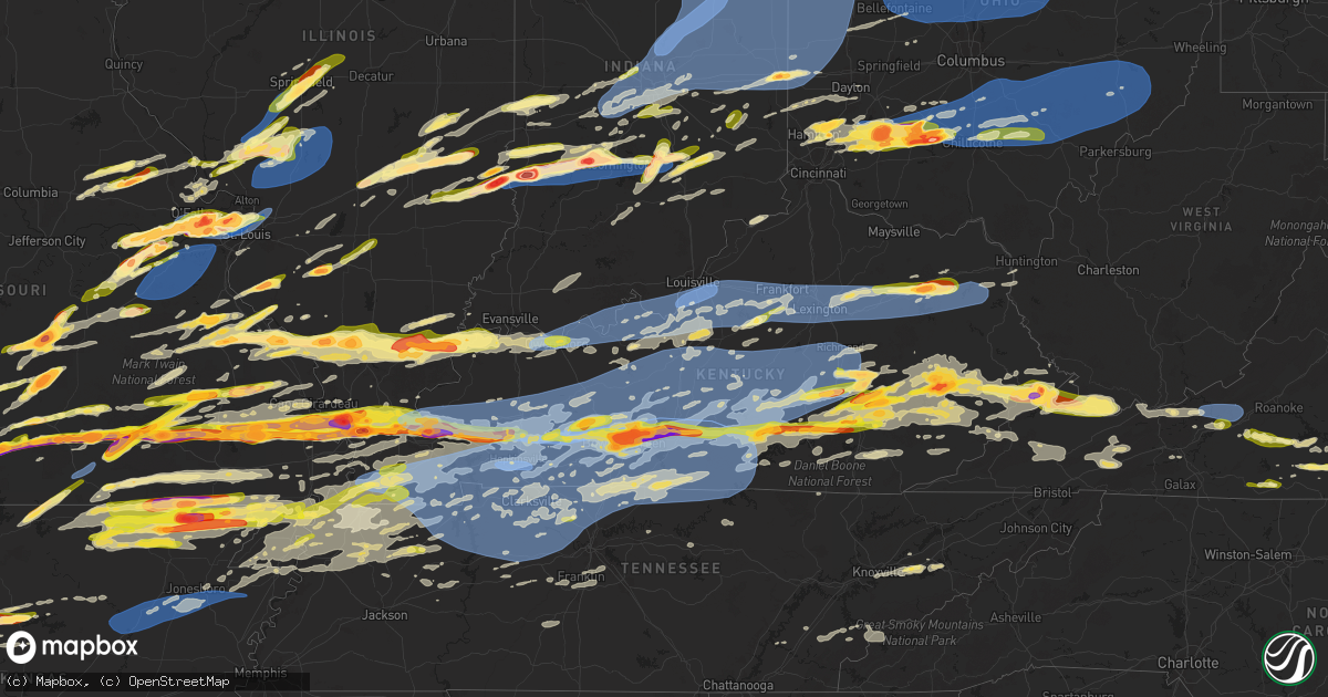
Hail Map in Kentucky on May 16, 2025
Get this storm
May 16 map
$229
one time, instant access
Download today. No call, no setup
Keep the $229
Bought the map and want the full workflow? Apply the entire $229 to a subscription within 7 days. None of it is wasted.
Every map, not just this one
This buys you this map. Subscription and you get every map we run, in the markets you choose from a few cities to whole states to nationwide. Plus real-time alerts the moment a storm fires.
Contact data
Name, contact info, occupancy, even credit band for addresses in the footprint. You go from where it hit to who to call.
Become the source they trust
Unlimited branding weather history reports on demand. You already have the documented answer ready for the property owner, and you are the one who showed up with it.
Property data and RoofTrace estimates
Pull up any address you have got, its value and the exact code rules for that jurisdiction, straight from One Click Code. Then RoofTrace estimates the squares, pitch, and roof value, priced the way you price.
Storm reports in Kentucky
Kentucky
| Date | Description |
|---|---|
| 05/16/20256:55 PM CDT | Report from mping: half dollar |
| 05/16/20256:54 PM CDT | A local report indicates a tornado near 1 ENE Clifty |
| 05/16/20255:57 PM CDT | A local report indicates 2.00 inch wind near Smithland |
| 05/16/20255:44 PM CDT | A local report indicates 1.00 inch wind near Kuttawa |
| 05/16/20255:32 PM CDT | A local report indicates 2.00 inch wind near Calvert City |
| 05/16/20255:11 PM CDT | A local report indicates 1.75 inch wind near 1 N Paducah |
| 05/16/20255:09 PM CDT | 1 inch hail and power lines/power poles broke across the road at the ema office. |
| 05/16/20255:02 PM CDT | A local report indicates 1.25 inch wind near 2 SE Heath |
| 05/16/20254:58 PM CDT | Reports of windows busted out from hail. |
| 05/16/20254:55 PM CDT | Report from mping: ping pong ball |
| 05/16/20254:54 PM CDT | Report from mping: quarter |
| 05/16/20254:44 PM CDT | A local report indicates 2.75 inch wind near 1 S Barlow |
| 05/16/20251:33 PM CDT | Pike county dispatch reported a utility line knocked down onto a roof and a power pole blown over in the 3000 block of fedscreek road. Time of occurrence estimated from |
| 05/16/20251:22 PM CDT | Pike county dispatch reported a tree hanging over and partially blocking east shelbiana road in the 4000 block. Event occurrence time estimated from radar. |
| 05/16/20251:21 PM CDT | Pike county dispatch reported a tree blown down and blocking raccoon road in the 6500 block. Road was closed. Time of occurrence estimated from radar. |
| 05/16/20251:15 PM CDT | State police reported a tree blown down near the millstone community. |
| 05/16/20251:13 PM CDT | Pike county dispatch reported a tree blown down and partially blocking hurricane road in the 4400 block. Time of occurrence estimated from radar. |
| 05/16/20251:00 PM CDT | At least ten reports of trees down with power outages throughout the county and impacting most major thoroughfares... Including us highway 421 and ky highway 80. Radar |
| 05/16/202512:58 PM CDT | Power pole blown down... Leaving power lines on a residence and transformer on a driveway in the 2000 block of ky-463. Time of occurrence estimated from radar. |
| 05/16/202512:54 PM CDT | State police reported a tree knocked down onto ky-7 in the vicinity of cornettsville. Time of event occurrence estimated from radar. |
| 05/16/202512:50 PM CDT | County dispatch reported a tree bringing down power lines onto a residence in the 2600 block of big creek road. Time of occurrence estimated from radar. |
| 05/16/202512:29 PM CDT | Trees down in the big creek area and power line down on hal rogers parkway near mile marker 26. |
| 05/16/202512:26 PM CDT | Several trees reported down in the otter creek rd and goose creek rd areas. |
| 05/16/202512:26 PM CDT | In or near whick along ky 1110 trees and powerlines were reported to have been blown down. The event time is radar estimated. |
| 05/16/202512:23 PM CDT | Tree down on power line. Time estimated from radar. Possible that damage was caused by subsequent storm about 30 minutes later. |
| 05/16/202512:21 PM CDT | Trees down on east shelbiana road between petyon creek and greesy creek road. |
| 05/16/202512:20 PM CDT | Trees down between the 400 and 500 block of lick branch road. |
| 05/16/202512:20 PM CDT | Multiple trees down along bar creek rd. Time estimated from radar. |
| 05/16/202512:18 PM CDT | A couple of trees down in the sublimity springs subdivision. |
| 05/16/202512:16 PM CDT | Several trees down in the curry branch rd and ky highway 80 area. |
| 05/16/202512:12 PM CDT | Report via the pike county em. |
| 05/16/202512:09 PM CDT | Trees were reported to have been blown down near bush elementary school along ky 80 in eastern laurel county with a picture relayed by a ham radio operator. The event t |
| 05/16/202512:08 PM CDT | A couple of trees down near the intersection of sasser school road and shields lane. |
| 05/16/202512:08 PM CDT | Tree down and blocking moores creek school road. Time estimated from radar. |
| 05/16/202512:07 PM CDT | A spotter in southeast london noted that trees were downed along barrett road as the storms moved through. Time estimated by radar. |
| 05/16/202512:03 PM CDT | Multiple photos of large tree snapped and split three ways and blocking the intersection of whitley street and jody street in london. Power pole snapped and power lines |
| 05/16/202512:03 PM CDT | Roof peeled off a business onto multiple adjacent vehicles. Vehicles have sustained unspecified damage. |
| 05/16/202512:03 PM CDT | Photos of two hailstones with diameter greater than 2 inches. Largest stone appears to be 2.75 inches or larger. |
| 05/16/202512:01 PM CDT | Time of occurrence estimated from radar. |
| 05/16/202511:51 AM CDT | Couple of trees down blocking the road near the intersection of clay hill road and kettlehead road. |
| 05/16/202511:49 AM CDT | Several trees down blocking close road. |
| 05/16/202511:49 AM CDT | Tree down on road. |
| 05/16/202511:48 AM CDT | Trees and power lines down along ky highway 3106 and ky highway 1275 n between monticello and steubenville. Exact location estimated. |
| 05/16/202511:46 AM CDT | Tree blocking road near 200 old bronston school road. |
| 05/16/202511:15 AM CDT | Hail fell from 12:15 to 12:20 pm. Photo provided to the office. |
| 05/16/202511:02 AM CDT | Picture on social media showed approximately egg-size hail. Time of occurrence estimated from radar. |
| 05/16/202510:57 AM CDT | County dispatch reported a tree blown down and partially blocking ky-2030. |
| 05/16/202510:56 AM CDT | Two trees down blocking the road 1100 block of plum fork in maloneton... Ky. Time estimated via radar. |
| 05/16/202510:42 AM CDT | Picture on social media shows approximately quarter-sized hail near wabd. Time of occurrence estimated from radar. |
| 05/16/202510:30 AM CDT | A local report indicates 1.00 inch wind near 4 NW Lecta |
| 05/16/202510:25 AM CDT | Tree damage resulting in 95 customers without power. |
| 05/16/202510:20 AM CDT | Tree damage resulting in over 50 customers without power. |
| 05/16/202510:00 AM CDT | Photo via social media of 2.00 to 2.50-inch diameter hail. Time estimated from radar. |
| 05/16/20259:58 AM CDT | Photo shared via social media of multiple hail stones of at least 2 inch diameter. |
| 05/16/20259:58 AM CDT | Emergency manager reported golf ball-sized hail along noble branch. |
| 05/16/20259:54 AM CDT | Tree down on martins trail outside of mckinney. |
| 05/16/20259:53 AM CDT | Nickel to quarter-sized hail observed at the wendell h ford airport. |
| 05/16/20259:48 AM CDT | Two trees blown down along turkey road near the intersection with stepstone road. |
| 05/16/20259:48 AM CDT | Tree blown into the power lines near the intersection of rocky branch road and main street. Event time estimated from radar. |
| 05/16/20259:43 AM CDT | Tree down on the 400 block of sharp road. |
| 05/16/20259:20 AM CDT | Powerlines down on forecast ave. |
| 05/16/20259:20 AM CDT | Tree... Power pole and power lines down just north of north bypass and old lebanon rd. |
| 05/16/20259:10 AM CDT | Tree down over the 200 block of blue jay road. |
| 05/16/20259:09 AM CDT | Tree down over the 600 block of coral ridge road. |
| 05/16/20259:00 AM CDT | Hail up to approximately egg size was reported along ky-290 between annville and mckee. Event time estimated from radar. |
| 05/16/20258:51 AM CDT | Report from mping: half dollar |
| 05/16/20258:48 AM CDT | Report from mping: quarter |
| 05/16/20258:44 AM CDT | Social media photos of estimated 2 to 3 inch diameter hail from the tyner lake area of jackson county. |
| 05/16/20258:37 AM CDT | Local business reported quarter size hail with picture to verify. |
| 05/16/20258:29 AM CDT | 1 tree down and small hail. |
| 05/16/20258:21 AM CDT | Large tree fell across a road and onto a house. Structural damage to the roof and roof structure. Time estimated from radar. |
| 05/16/20258:20 AM CDT | Tree down on mercer rd near riverside. |
| 05/16/20258:08 AM CDT | A local report indicates 1.50 inch wind near 2 SSW South Hill |
| 05/16/20257:43 AM CDT | A local report indicates 1.00 inch wind near 3 SW Berea |
| 05/16/20257:08 AM CDT | A local report indicates 1.00 inch wind near 1 SSW Berea |
| 05/16/20257:00 AM CDT | Tree down on cartersville road near the county line. |
| 05/16/202512:24 AM CDT | County dispatch reported trees blown down in many parts of the county but did not provide specific details. Ky-160 and ky-1103 apparently stood out as highways which sa |
| 05/16/202512:07 AM CDT | Ky-7 closed by large tree blown down and blocking both lanes. Power lines were knock down. Event time estimated from radar. |
| 05/15/202511:55 PM CDT | Martin county dispatch reported over a dozen instances of trees blown down onto or along highways around the county. Some of the trees involved power and phone lines. T |
| 05/15/202511:31 PM CDT | Tree was blown down and blocked michigan avenue adjacent to the monticello wayne county park. Event time estimated from radar. |
| 05/15/202511:30 PM CDT | Tree was blown down onto a mobile home and involved electrical lines in the 500 block of south main street. Event time estimated from radar. |
| 05/15/202511:26 PM CDT | County dispatch reported multiple trees blown down along ky-92 west of monticello. Event time estimated from radar and kentucky mesonet station monticello 4 nw. |
| 05/15/202511:16 PM CDT | Multiple trees down over goodin road. |
| 05/15/202511:09 PM CDT | County dispatch reported that many individual trees blown down around the county... But provided no specific details. |
| 05/15/202511:07 PM CDT | Multiple trees down in columbia. |
| 05/15/202511:07 PM CDT | Millers creek fire rescue clear out over 50 trees blown down into the local roadways. |
| 05/15/202511:05 PM CDT | Multiple trees blown down in the vicinity of stanton. Event time estimated from radar. |
| 05/15/202511:05 PM CDT | A local report indicates 59 MPH wind near 3 W Burkesville |
| 05/15/202510:57 PM CDT | Picture on social media shows tree blown down onto stacy lane road. Event time estimated from radar. |
| 05/15/202510:55 PM CDT | A local report indicates 58 MPH wind near 4 NNW Berea |
| 05/15/202510:49 PM CDT | A tree blew down on hampton way. |
| 05/15/202510:47 PM CDT | Likely tornado damage shown at the london airport. |
| 05/15/202510:45 PM CDT | Tree down on broughtontown road. |
| 05/15/202510:43 PM CDT | Tree down on powerlines on the 2400 block of wallacetown road. |
| 05/15/202510:42 PM CDT | Tree down on the 700 block of clear fork road. |
| 05/15/202510:42 PM CDT | Tree down on a house and went through roof on the 100 block of spring valley drive. |
| 05/15/202510:40 PM CDT | Tree down over the 4100 block of preachersville road blocking two lanes. |
| 05/15/202510:40 PM CDT | County dispatch reported a tree blocking willoughby town road near the intersection of ky-213. Time of event occurrence estimated from radar. |
| 05/15/202510:36 PM CDT | Tree down over the 200 block of lexington road. |
| 05/15/202510:36 PM CDT | Tree down over the 100 block of kelly ridge road. |
| 05/15/202510:36 PM CDT | Tree down on a home on the 100 block of york street. |
| 05/15/202510:31 PM CDT | Tree down on powerlines on conner avenue. |
| 05/15/202510:30 PM CDT | A local report indicates 60 MPH wind near 2 SSE Hays |
| 05/15/202510:26 PM CDT | Tree down. Time estimated by radar. |
| 05/15/202510:25 PM CDT | Tree blown down and partially blocking rockcastle road near the intersection with abbs lane. Event time estimated from radar. |
| 05/15/202510:25 PM CDT | Tree down on normans camp road. |
| 05/15/202510:25 PM CDT | Corrects previous tstm wnd dmg report from 1 sse louisa. Tree damage resulting in 95 customers without power. |
| 05/15/202510:24 PM CDT | Tree down on powerlines on the 400 block of bailey pike. |
| 05/15/202510:20 PM CDT | Corrects previous tstm wnd dmg report from 7 se blaine. Tree damage resulting in over 50 customers without power. |
| 05/15/202510:19 PM CDT | A local report indicates 65 MPH wind near 1 WNW Woodburn |
| 05/15/202510:17 PM CDT | Corrects previous tstm wnd gst report from 1 ese bowling green. |
| 05/15/202510:17 PM CDT | Large limb down behind a home in franklin. |
| 05/15/202510:15 PM CDT | A local report indicates 75 MPH wind near 2 NW Plano |
| 05/15/202510:14 PM CDT | High winds and some broken tree tops. Power out. Time estimated from radar. |
| 05/15/202510:12 PM CDT | Tree damage resulting in 133 customers without power. Time is estimated by radar. |
| 05/15/202510:10 PM CDT | Picture of a tree that with an uprooting pulled up part of the black top in a parking lot and landed on a van. Time of damage unknown but likely with the second wave th |
| 05/15/202510:10 PM CDT | A local report indicates 63 MPH wind near 6 W Lexington |
| 05/15/202510:07 PM CDT | Multiple trees down in the gravel switch area. |
| 05/15/202510:07 PM CDT | 4 trees blown over and uprooted on london drive. |
| 05/15/202510:00 PM CDT | Large hardwood tree split. |
| 05/15/202510:00 PM CDT | Mesonet station 1578w logan aluminum. |
| 05/15/20259:59 PM CDT | Multiple trees down in the lebanon area. One tree went through a roof of a home. |
| 05/15/20259:58 PM CDT | Several trees down around olive hill. Time estimated by radar. |
| 05/15/20259:57 PM CDT | Trained spotter reported tornado in somerset. |
| 05/15/20259:55 PM CDT | A local report indicates 59 MPH wind near 3 ENE Loretto |
| 05/15/20259:55 PM CDT | Tds on radar. |
| 05/15/20259:51 PM CDT | Multiple trees down in the loretto area. |
| 05/15/20259:51 PM CDT | Multiple trees down in the eastern part of the county. |
| 05/15/20259:50 PM CDT | Mesonet station zion elkton ky 5 sw. |
| 05/15/20259:47 PM CDT | Power lines down blocking the road. |
| 05/15/20259:42 PM CDT | Tree reported blown down along ccc trail. Event time estimated from radar. |
| 05/15/20259:41 PM CDT | A local report indicates 1.00 inch wind near Oak Grove |
| 05/15/20259:38 PM CDT | Multiple trees down in windsor. |
| 05/15/20259:38 PM CDT | Pictures on social media show multiple trees blown down... Including onto residence and vehicles along fallen road. Minor wind damage was also sustained to siding and r |
| 05/15/20259:35 PM CDT | County dispatch reported up to golf ball-sized hail in morehead. |
| 05/15/20259:35 PM CDT | Multiple power poles snapped near bullitt east high school. |
| 05/15/20259:34 PM CDT | Large tree down on hwy 84. Time estimated from radar. |
| 05/15/20259:33 PM CDT | Tree blown down along ky-191 at gap between trent and stillwater. Event time estimated from radar. |
| 05/15/20259:33 PM CDT | County dispatch reported at least a dozen instances of a trees blown down around the county... Including along wind cave road... Ky-89... And ledger fork road. Some of |
| 05/15/20259:32 PM CDT | Report from mping: quarter |
| 05/15/20259:32 PM CDT | Report from mping: quarter |
| 05/15/20259:30 PM CDT | Lopsided hail measuring 2 inches in diameter. Time is approximate and based on radar. |
| 05/15/20259:30 PM CDT | Hardin county mesonet. |
| 05/15/20259:30 PM CDT | Spencer county mesonet. |
| 05/15/20259:30 PM CDT | A local report indicates 59 MPH wind near 4 ENE Howe Valley |
| 05/15/20259:30 PM CDT | A local report indicates 59 MPH wind near 2 W Wakefield |
| 05/15/20259:29 PM CDT | A tree was blown down along the east bound lane of the mountain parkway between pine ridge and campton. Event time estimated from radar. |
| 05/15/20259:29 PM CDT | Report from mping: quarter |
| 05/15/20259:27 PM CDT | Multiple trees down in the southeast part of the county. |
| 05/15/20259:25 PM CDT | Corrects previous tstm wnd dmg report from 1 ene mount washington. Multiple power poles snapped near bullitt east high school. |
| 05/15/20259:23 PM CDT | Multiple trees and large limbs down in the elk creek area. |
| 05/15/20259:23 PM CDT | A local report indicates 1.75 inch wind near 1 WNW Russell Springs |
| 05/15/20259:17 PM CDT | A few trees down and large limbs down at intersection of union hill rd and murray highway. |
| 05/15/20259:16 PM CDT | Measured from a home weather station and a hand held anemometer. |
| 05/15/20259:15 PM CDT | Tree down on the 2500 block of granger road. |
| 05/15/20259:15 PM CDT | Tree down over the road near the 4200 block of cane run road. |
| 05/15/20259:15 PM CDT | Tree down over hubbard lane. |
| 05/15/20259:14 PM CDT | Tree down on a home on the 2500 block of adrienne way. |
| 05/15/20259:12 PM CDT | Multiple trees down in morgantown. |
| 05/15/20259:12 PM CDT | Tree down over the 200 block of bardstown road. |
| 05/15/20259:10 PM CDT | Heavy metal fences blown down... Siding removed from mobile homes and some smaller trees down. Hand held anemometer measured 70 mph before blown out of hand. Brief pea |
| 05/15/20259:10 PM CDT | Tree down over the 3500 block of preston highway. |
| 05/15/20259:10 PM CDT | Tree down on the 2500 block of bells mill road. |
| 05/15/20259:09 PM CDT | Several trees down across the county. |
| 05/15/20259:09 PM CDT | Multiple trees down in fairplay. |
| 05/15/20259:09 PM CDT | Pictures from social media show multiple trees blown down on tipton ridge along ky-52. Event time estimated from radar. |
| 05/15/20259:08 PM CDT | Tree fell on house in the 5100 block of yew ln. |
| 05/15/20259:08 PM CDT | Tree down over the 200 block of east martin place. |
| 05/15/20259:06 PM CDT | Large tree down at the intersection of dave smith road and sunny lane. |
| 05/15/20259:06 PM CDT | A local report indicates 82 MPH wind near 1 NNE Louisville Int'l |
| 05/15/20259:06 PM CDT | Tree down over cupio lane. |
| 05/15/20259:03 PM CDT | Trained spotter called to report two trees were down near the intersection of majestic dr and cr-1446. Time estimated from radar. |
| 05/15/20259:00 PM CDT | Partial fence blown down at murray state university. Numerous large limbs down in the city of murray. |
| 05/15/20258:59 PM CDT | Large tree reportedly blown down on big perry road in the 2200 block. Event time estimated from radar. |
| 05/15/20258:58 PM CDT | 61 kt measured at murray aiport. |
| 05/15/20258:55 PM CDT | On hwy 80 at the graves/calloway county line. Power flashes seen. |
| 05/15/20258:50 PM CDT | Tree down over the intersection of new state road and highway 376. |
| 05/15/20258:49 PM CDT | Trees and power lines down in the city of mayfield. |
| 05/15/20258:47 PM CDT | Tree down over the intersection of rhodelia road and roy hardesty road. |
| 05/15/20258:46 PM CDT | Tree uprooted and hanging over the highway... Stuck in another tree... Along the 4800 block of goddard road. |
| 05/15/20258:46 PM CDT | Trees blown down and blocking half of the highway in the 15400 block of morehead road. Event time estimated from radar. |
| 05/15/20258:46 PM CDT | Tree blown down and blocking rawlins road. Event time estimated from radar. |
| 05/15/20258:46 PM CDT | Report from mping: quarter |
| 05/15/20258:43 PM CDT | Tree down along hawesville easton rd between lamastus and claud bolin hill. Time estimated from radar. |
| 05/15/20258:42 PM CDT | Tree on a house. |
| 05/15/20258:39 PM CDT | Tree down on the 7200 block of state route 69. |
| 05/15/20258:38 PM CDT | Large tree down on the 9200 block of state route 69. |
| 05/15/20258:35 PM CDT | A local report indicates a tornado near 6 SE Princeton |
| 05/15/20258:30 PM CDT | Mesonet station prnc princeton ky 2 se. |
| 05/15/20258:24 PM CDT | Tree down on a powerline on the 1000 block of state route 271 south. |
| 05/15/20258:24 PM CDT | Roof off building in downtown princeton. |
| 05/15/20258:17 PM CDT | A local report indicates 1.00 inch wind near Owensboro |
| 05/15/20258:12 PM CDT | Tree down at the intersection of old happy valley road and happy valley road. |
| 05/15/20257:54 PM CDT | Picture on x. |
| 05/15/20257:54 PM CDT | Large tree down on road. 600 block of bethel ln. Time stamp on image shows it occurred with first storm that crossed the area that evening. Time estimated from radar. |
| 05/15/20257:50 PM CDT | Average hail was golf ball size. Largest baseball. Minor leaf damage. Car dents. Hail lasted 10 minutes. Time estimated from radar. |
| 05/15/20257:49 PM CDT | A local report indicates 1.00 inch wind near Plum Springs |
| 05/15/20257:48 PM CDT | Picture on x. |
| 05/15/20257:48 PM CDT | Picture on x. |
| 05/15/20257:47 PM CDT | Report from mping: golf ball |
| 05/15/20257:46 PM CDT | A local report indicates 1.00 inch wind near 1 NNW Bowling Green |
| 05/15/20257:46 PM CDT | Report from mping: tennis ball |
| 05/15/20257:46 PM CDT | Report from mping: hen egg |
| 05/15/20257:46 PM CDT | Report from mping: golf ball |
| 05/15/20257:42 PM CDT | Power lines down and possible gas leak near us 60 morganfield. |
| 05/15/20257:42 PM CDT | Report from mping: quarter |
| 05/15/20257:42 PM CDT | Picture on twitter. |
| 05/15/20257:42 PM CDT | Report from mping: quarter |
| 05/15/20257:41 PM CDT | A local report indicates 1.50 inch wind near 2 N Bowling Green |
| 05/15/20257:40 PM CDT | Report from mping: half dollar |
| 05/15/20257:40 PM CDT | A local report indicates 1.25 inch wind near 1 NW Bowling Green |
| 05/15/20257:39 PM CDT | Picture on x. |
| 05/15/20257:36 PM CDT | A local report indicates 1.00 inch wind near Alton |
| 05/15/20257:34 PM CDT | A local report indicates a tornado near 1 W Morganfield |
| 05/15/20257:28 PM CDT | A local report indicates 1.00 inch wind near 1 NE Hadley |
| 05/15/20257:24 PM CDT | Reported on anderson rd. |
| 05/15/20257:06 PM CDT | Trees snapped power lines down. |
All States Impacted by Hail Map on May 16, 2025
Cities Impacted by Hail Map on May 16, 2025
- Cash, AR
- Harned, KY
- Garfield, KY
- Newport, AR
- Vevay, IN
- Greenville, KY
- White Plains, KY
- Berea, KY
- Mount Vernon, KY
- Fairmount City, PA
- Mayport, PA
- Kennett, MO
- Hornersville, MO
- Princeton, KY
- Portageville, MO
- Hayti, MO
- McKee, KY
- Tiptonville, TN
- Bragg City, MO
- Custer, KY
- Irvington, KY
- Vine Grove, KY
- Warsaw, KY
- Ghent, KY
- Holcomb, MO
- Springfield, KY
- Willisburg, KY
- Gobler, MO
- Steele, MO
- Madisonville, KY
- Hickman, KY
- East Prairie, MO
- Eddyville, KY
- Cadiz, KY
- Union City, TN
- Jonesboro, AR
- Caruthersville, MO
- Arbyrd, MO
- Cerulean, KY
- Weiner, AR
- Harrisburg, AR
- Rineyville, KY
- Radcliff, KY
- Ridgely, TN
- Clinton, KY
- Crofton, KY
- Nortonville, KY
- Powderly, KY
- Central City, KY
- Paint Lick, KY
- Elizabethtown, KY
- West Point, KY
- Lebanon Junction, KY
- Lake City, AR
- Hornbeak, TN
- Hickory, KY
- Troy, TN
- Fulton, KY
- Fancy Farm, KY
- Mayfield, KY
- Rochester, KY
- Morgantown, KY
- Beechmont, KY
- Drakesboro, KY
- Beech Creek, KY
- Browder, KY
- Boston, KY
- Elkton, KY
- Hopkinsville, KY
- Belton, KY
- Lewisburg, KY
- Cecilia, KY
- Fort Knox, KY
- Bay, AR
- Monette, AR
- South Fulton, TN
- Water Valley, KY
- Wingo, KY
- Dunmor, KY
- Campbellsville, KY
- Black Oak, AR
- Benton, KY
- Shepherdsville, KY
- Leachville, AR
- Coxs Creek, KY
- Manila, AR
- Caraway, AR
- Bardstown, KY
- Obion, TN
- Thida, AR
- Bradford, AR
- Oil Trough, AR
- Tuckerman, AR
- Amagon, AR
- Fisher, AR
- Pleasant Plains, AR
- Trumann, AR
- Etowah, AR
- Sedalia, KY
- Bowling Green, KY
- Bloomfield, KY
- Clarkson, KY
- Columbia, KY
- Hazel, KY
- Murray, KY
- Farmington, KY
- Millwood, KY
- Trenton, KY
- Pembroke, KY
- Martin, TN
- Blytheville, AR
- Elk Horn, KY
- Chaplin, KY
- Rockfield, KY
- Jetson, KY
- Kirksey, KY
- Symsonia, KY
- Liberty, KY
- Hardin, KY
- Guthrie, KY
- Gilbertsville, KY
- Kuttawa, KY
- Almo, KY
- Beaver Dam, KY
- Eubank, KY
- Crab Orchard, KY
- Marston, MO
- Hustonville, KY
- Lawrenceburg, KY
- Bee Spring, KY
- Sweeden, KY
- Brownsville, KY
- Mount Eden, KY
- Oakland, KY
- Smiths Grove, KY
- Hodgenville, KY
- Dexter, KY
- Dresden, TN
- Palmersville, TN
- Dukedom, TN
- Finley, TN
- Roundhill, KY
- Livingston, KY
- Newbern, TN
- New Haven, KY
- Rives, TN
- Yosemite, KY
- Versailles, KY
- East Bernstadt, KY
- Russellville, KY
- Annville, KY
- Sharon, TN
- Bonnieville, KY
- Upton, KY
- Sonora, KY
- Munfordville, KY
- Magnolia, KY
- Park City, KY
- Rocky Hill, KY
- Cave City, KY
- Kings Mountain, KY
- Stanford, KY
- Middleburg, KY
- Waynesburg, KY
- Puryear, TN
- Cottage Grove, TN
- Tyner, KY
- Gracey, KY
- Herndon, KY
- Mount Sherman, KY
- Harrodsburg, KY
- Greensburg, KY
- Canmer, KY
- Summersville, KY
- New Concord, KY
- Salvisa, KY
- Buffalo, KY
- Paris, TN
- Sandgap, KY
- Orlando, KY
- Vincent, KY
- Booneville, KY
- Horse Cave, KY
- Hardyville, KY
- Sharon Grove, KY
- Buchanan, TN
- Lebanon, KY
- Sextons Creek, KY
- Buckhorn, KY
- Ricetown, KY
- Mistletoe, KY
- Jackson, KY
- Bradfordsville, KY
- Gravel Switch, KY
- Dover, TN
- Auburn, KY
- Manchester, KY
- Whick, KY
- Lost Creek, KY
- Clayhole, KY
- Rowdy, KY
- Woodburn, KY
- Big Sandy, TN
- Richmond, KY
- Dunnville, KY
- Clarksville, TN
- Woodlawn, TN
- Knifley, KY
- Leitchfield, KY
- Mammoth Cave, KY
- Olmstead, KY
- Allensville, KY
- Somerset, KY
- Oak Grove, KY
- Adams, TN
- Cedar Hill, TN
- Springfield, TN
- Glasgow, KY
- Hueysville, KY
- Adairville, KY
- Franklin, KY
- Alvaton, KY
- Brodhead, KY
- Edmonton, KY
- Scottsville, KY
- Portland, TN
- Orlinda, TN
- Leburn, KY
- Vest, KY
- Gunlock, KY
- Cross Plains, TN
- Beattyville, KY
- Vancleve, KY
- Austin, KY
- Lucas, KY
- Adolphus, KY
- Westmoreland, TN
- Center, KY
- Cottontown, TN
- Glens Fork, KY
- White House, TN
- Salem, NJ
- Rousseau, KY
- Summer Shade, KY
- Jenkins, KY
- Neon, KY
- McRoberts, KY
- Jackhorn, KY
- Lafayette, TN
- Oneida, KY
- Gays Creek, KY
- Fountain Run, KY
- Salyersville, KY
- Windsor, KY
- Virgie, KY
- Robinson Creek, KY
- Knob Lick, KY
- Mount Hermon, KY
- Bethpage, TN
- Tompkinsville, KY
- Holland, KY
- Etoile, KY
- Shiloh, NJ
- Bridgeton, NJ
- Gamaliel, KY
- Bulan, KY
- Russell Springs, KY
- Burkesville, KY
- Garrett, KY
- Jamestown, KY
- Hazard, KY
- Ashcamp, KY
- Emmalena, KY
- Chavies, KY
- Ary, KY
- Mousie, KY
- Pikeville, KY
- Shelbiana, KY
- Wayland, KY
- Raven, KY
- Garner, KY
- Hi Hat, KY
- Dema, KY
- McDowell, KY
- Ozark, AR
- Altus, AR
- Lackey, KY
- Minnie, KY
- Printer, KY
- Grethel, KY
- Harold, KY
- Albany, KY
- Science Hill, KY
- Beaver, KY
- Rector, AR
- Marmaduke, AR
- Nancy, KY
- Kite, KY
- Langley, KY
- Wheelwright, KY
- Topmost, KY
- Bypro, KY
- Prestonsburg, KY
- Melvin, KY
- Drift, KY
- Bevinsville, KY
- Hindman, KY
- Pippa Passes, KY
- Clarksville, AR
- Coal Hill, AR
- Hartman, AR
- Teaberry, KY
- Elkhorn City, KY
- Regina, KY
- Belcher, KY
- Hellier, KY
- Millville, NJ
- Ferguson, KY
- London, KY
- Monticello, KY
- Weeksbury, KY
- Mouthcard, KY
- Lick Creek, KY
- Lamar, AR
- Hagarville, AR
- Springfield, MO
- Alpha, KY
- Burnside, KY
- Krypton, KY
- Shelby Gap, KY
- Strafford, MO
- Marshfield, MO
- Dover, AR
- Pelsor, AR
- Niangua, MO
- Parkers Lake, KY
- Grundy, VA
- Big Rock, VA
- Garrison, MO
- Taneyville, MO
- Corbin, KY
- Keavy, KY
- Whitley City, KY
- Breaks, VA
- Phyllis, KY
- Ava, MO
- Chadwick, MO
- Oldfield, MO
- Lebanon, MO
- Mansfield, MO
- Norwood, MO
- Macomb, MO
- Mountain Grove, MO
- Oakwood, VA
- Pilgrims Knob, VA
- Seymour, MO
- Lily, KY
- Sizerock, KY
- Hyden, KY
- Bear Branch, KY
- Vansant, VA
- Haysi, VA
- Jolo, WV
- Iaeger, WV
- Eastern, KY
- Big Creek, KY
- Hector, AR
- Squires, MO
- Richland, MO
- Grovespring, MO
- Falcon, MO
- Cabool, MO
- Drury, MO
- Vanzant, MO
- Laquey, MO
- Busy, KY
- Wooton, KY
- Georgetown, DE
- Bonnyman, KY
- Thousandsticks, KY
- Forsyth, MO
- Hartville, MO
- Jerusalem, AR
- Cub Run, KY
- Cape May Court House, NJ
- Gray, KY
- Cannon, KY
- Heidrick, KY
- Barbourville, KY
- Jewell Ridge, VA
- Whitewood, VA
- Raysal, WV
- Berwind, WV
- Raven, VA
- Woodbine, KY
- Bimble, KY
- Paynesville, WV
- War, WV
- Rockholds, KY
- Bandy, VA
- Combs, KY
- Squire, WV
- Smilax, KY
- Guston, KY
- Scotland, AR
- Fort Leonard Wood, MO
- Waynesville, MO
- Saint Robert, MO
- Graff, MO
- Plato, MO
- Huggins, MO
- Roby, MO
- Licking, MO
- Lynchburg, MO
- Delmont, NJ
- Woodbine, NJ
- Hinkle, KY
- Walker, KY
- Flat Lick, KY
- Girdler, KY
- Scalf, KY
- Stone Harbor, NJ
- Millsboro, DE
- Redfox, KY
- Whitesburg, KY
- Viper, KY
- Jeff, KY
- Mallie, KY
- Pine Top, KY
- Happy, KY
- Blackey, KY
- Cornettsville, KY
- Vicco, KY
- Clinton, AR
- Avalon, NJ
- Sassafras, KY
- Scuddy, KY
- Hallie, KY
- Willow Springs, MO
- Devils Elbow, MO
- Dixon, MO
- Sea Isle City, NJ
- Newburg, MO
- Elk Creek, MO
- Solo, MO
- Wildwood, NJ
- Jerome, MO
- Dagsboro, DE
- Rolla, MO
- Houston, MO
- Yukon, MO
- Summersville, MO
- Eunice, MO
- Hermann, MO
- Berger, MO
- Fallentimber, PA
- Rocky Gap, VA
- Bastian, VA
- Narrows, VA
- Ocean City, NJ
- Williamsburg, MO
- Kingdom City, MO
- Fulton, MO
- Auxvasse, MO
- Bledsoe, KY
- Baxter, KY
- Eolia, KY
- Martinsburg, MO
- Benton City, MO
- Wellsville, MO
- Montgomery City, MO
- Success, MO
- Bucyrus, MO
- Bluefield, VA
- Bluefield, WV
- Falls Mills, VA
- Leesburg, NJ
- Duke, MO
- Jeremiah, KY
- Partridge, KY
- Millstone, KY
- Mayking, KY
- Ermine, KY
- Roxana, KY
- Premium, KY
- Linefork, KY
- Isom, KY
- Thornton, KY
- Letcher, KY
- Shirley, AR
- Fairfield Bay, AR
- Mountain View, MO
- Middletown, MO
- Bellflower, MO
- Bland, VA
- Belle, MO
- Frankford, DE
- New Haven, MO
- Pound, VA
- Appalachia, VA
- Wise, VA
- Crocker, MO
- Owensville, MO
- Gerald, MO
- Gassville, AR
- Cotter, AR
- Marthasville, MO
- Bland, MO
- Eminence, MO
- Hartshorn, MO
- Washington, MO
- Rosebud, MO
- Birch Tree, MO
- Leslie, MO
- Beaufort, MO
- Union, MO
- Leasburg, MO
- Cuba, MO
- Steelville, MO
- Mountain Home, AR
- Eolia, MO
- Augusta, MO
- Warriors Mark, PA
- Castlewood, VA
- Dante, VA
- Nora, VA
- Saint Paul, VA
- Coeburn, VA
- Gamaliel, AR
- Silex, MO
- Bowling Green, MO
- Henderson, AR
- Staffordsville, VA
- Pearisburg, VA
- Truxton, MO
- High Hill, MO
- Tyrone, PA
- Saint James, MO
- Selbyville, DE
- Milton, DE
- Lewes, DE
- Defiance, MO
- Foristell, MO
- Clarkridge, AR
- Caulfield, MO
- Bakersfield, MO
- Gepp, AR
- Moody, MO
- Wentzville, MO
- Winona, MO
- O'Fallon, MO
- Saint Charles, MO
- West Plains, MO
- Denmark, WI
- Mineral Point, MO
- Potosi, MO
- Spruce Creek, PA
- Pennsylvania Furnace, PA
- Varney, KY
- Tigerton, WI
- Wittenberg, WI
- Troy, MO
- Elsberry, MO
- Port Matilda, PA
- Chesterfield, MO
- Bishopville, MD
- Fedscreek, KY
- Kimper, KY
- Steele, KY
- Pulaski, VA
- Dublin, VA
- Radford, VA
- State College, PA
- Hurley, VA
- Mohawk, WV
- Cleveland, VA
- Bradleyville, MO
- Tazewell, VA
- Tannersville, VA
- Ozone, AR
- Phelps, KY
- Raccoon, KY
- Lebanon, VA
- Bays, KY
- Clarksville, MO
- Bourbon, MO
- Christiansburg, VA
- Pilot, VA
- Riner, VA
- Floyd, VA
- Check, VA
- Blacksburg, VA
- Van Buren, MO
- Fremont, MO
- Belspring, VA
- Newport, VA
- Eggleston, VA
- Pembroke, VA
- Parrott, VA
- Elliston, VA
- Shawsville, VA
- Saint Peters, MO
- Wildwood, MO
- Batchtown, IL
- Hamburg, IL
- Hardin, IL
- Ballwin, MO
- Saint Louis, MO
- Maryland Heights, MO
- Earth City, MO
- Ellington, MO
- Brussels, IL
- Golden Eagle, IL
- Petersburg, PA
- Luxemburg, WI
- Saltville, VA
- Ceres, VA
- Huntingdon, PA
- Ocean City, MD
- Bonne Terre, MO
- Old Monroe, MO
- Moscow Mills, MO
- Bowler, WI
- Winfield, MO
- Foley, MO
- Dora, MO
- Harpers Ferry, WV
- Round Hill, VA
- Broadford, VA
- Saint Albans, MO
- Labadie, MO
- Sullivan, MO
- Bridgeton, MO
- Saint Ann, MO
- Hazelwood, MO
- Florissant, MO
- Fieldon, IL
- Kane, IL
- Jerseyville, IL
- Belleville, PA
- Rockbridge, IL
- Redford, MO
- Purcellville, VA
- Copper Hill, VA
- Greenfield, IL
- Carrollton, IL
- Chesterfield, IL
- Ellsinore, MO
- Chilhowie, VA
- Meadowview, VA
- Marion, VA
- Glade Spring, VA
- Edgar Springs, MO
- Pomona, MO
- Callaway, VA
- Oldtown, MD
- Bloomsdale, MO
- Prairie Du Rocher, IL
- Festus, MO
- Fults, IL
- Lewistown, PA
- Piedmont, MO
- Mill Spring, MO
- Lesterville, MO
- Venice, IL
- Granite City, IL
- Madison, IL
- Vulcan, MO
- Annapolis, MO
- Des Arc, MO
- Lovejoy, IL
- East Saint Louis, IL
- Red Bud, IL
- McVeytown, PA
- Rocky Mount, VA
- Grafton, IL
- Mountain, WI
- Ellenburg Depot, NY
- Altona, NY
- Mooers Forks, NY
- Fidelity, IL
- Medora, IL
- Wytheville, VA
- Hettick, IL
- Palmyra, IL
- Flintstone, MD
- Little Orleans, MD
- Boones Mill, VA
- Waterloo, IL
- Waterford, VA
- Leesburg, VA
- Williamsville, MO
- Greenville, MO
- Villa Ridge, MO
- Wiley Ford, WV
- Cumberland, MD
- Frostburg, MD
- Lonaconing, MD
- Ridgeley, WV
- Rawlings, MD
- Great Cacapon, WV
- Waverly, IL
- Virden, IL
- Edwardsville, IL
- Collinsville, IL
- Glen Carbon, IL
- Loami, IL
- Chatham, IL
- Auburn, IL
- New Berlin, IL
- Springfield, IL
- New Athens, IL
- Lenzburg, IL
- Marissa, IL
- Rochester, IL
- Riverton, IL
- Dickerson, MD
- Laurel, DE
- Max Meadows, VA
- Ivanhoe, VA
- Austinville, VA
- Baldwin, IL
- Carlinville, IL
- Wappapello, MO
- Carlyle, IL
- Fredericktown, MO
- Appomattox, VA
- Irvine, KY
- Shipman, IL
- Granville, PA
- Glade Hill, VA
- Pacific, MO
- Salem, MO
- Girard, IL
- Gillespie, IL
- Litchfield, IL
- McGee, MO
- Nilwood, IL
- Waggoner, IL
- Raymond, IL
- Marquand, MO
- Dawson, IL
- Sherman, IL
- Williamsville, IL
- Buffalo, IL
- Mifflin, PA
- Farmersville, IL
- Silva, MO
- Patterson, MO
- Port Royal, PA
- Nashville, IL
- Poolesville, MD
- Martinsville, VA
- Keyesport, IL
- Greenville, IL
- Cadet, MO
- Dodgeville, WI
- Mineral Point, WI
- Cantrall, IL
- Lovettsville, VA
- Centerville, MO
- Bunker, MO
- Farmville, VA
- Coulterville, IL
- Oakdale, IL
- Germantown, MD
- Potomac, MD
- Clarksburg, MD
- Kiel, WI
- Newton, WI
- Valders, WI
- Gretna, VA
- Cherryville, MO
- Davisville, MO
- Okawville, IL
- Millville, WV
- Charles Town, WV
- Manitowoc, WI
- Reedsville, WI
- Advance, MO
- Zalma, MO
- Sturdivant, MO
- Lowndes, MO
- Gipsy, MO
- Puxico, MO
- Brownwood, MO
- Millerstown, PA
- Ickesburg, PA
- Bloomfield, MO
- Patton, MO
- Martinsburg, WV
- Hedgesville, WV
- Gerrardstown, WV
- Inwood, WV
- Kearneysville, WV
- Shepherdstown, WV
- Sharpsburg, MD
- Shenandoah Junction, WV
- Pleasant Plains, IL
- Barneveld, WI
- Callands, VA
- Axton, VA
- Black, MO
- Modesto, IL
- Ranson, WV
- Gaithersburg, MD
- Rockville, MD
- Park Hills, MO
- Collinsville, VA
- Fieldale, VA
- Addieville, IL
- Marble Hill, MO
- Berryville, VA
- Ridgeway, WI
- Pawnee, IL
- Damascus, MD
- Patrick Springs, VA
- Stuart, VA
- Columbia, IL
- Harvel, IL
- Morrisonville, IL
- Mount Pulaski, IL
- Bluemont, VA
- Elkhart, IL
- Middleburg, VA
- Hamilton, VA
- Oran, MO
- Bell City, MO
- Benton, MO
- Palmyra, WI
- Whitewater, WI
- Fort Atkinson, WI
- Jefferson, WI
- Helenville, WI
- Sullivan, WI
- Dousman, WI
- Oconomowoc, WI
- Delafield, WI
- Nashotah, WI
- Okauchee, WI
- Hartland, WI
- Rubicon, WI
- Hartford, WI
- Colgate, WI
- Slinger, WI
- Hubertus, WI
- Richfield, WI
- Newport, PA
- Myersville, MD
- Frederick, MD
- Middletown, MD
- Jefferson, MD
- Richview, IL
- Glenallen, MO
- East Carondelet, IL
- Chatham, VA
- Shobonier, IL
- Mechanicsburg, IL
- Edinburg, IL
- Dry Fork, VA
- Blairs, VA
- Frenchville, PA
- Burfordville, MO
- Nathalie, VA
- Upperville, VA
- Belgrade, MO
- De Soto, MO
- Blackwell, MO
- Divernon, IL
- Bassett, VA
- Critz, VA
- Westminster, MD
- Taneytown, MD
- Dupo, IL
- Littlestown, PA
- Paeonian Springs, VA
- Bethesda, MD
- Knoxville, MD
- Tuscarora, MD
- Point Of Rocks, MD
- Adamstown, MD
- Brunswick, MD
- Rohrersville, MD
- Burkittsville, MD
- Phenix, VA
- Brookneal, VA
- Farmington, MO
- Valles Mines, MO
- French Village, MO
- Sainte Genevieve, MO
- Modoc, IL
- Ellis Grove, IL
- Clearfield, PA
- Sikeston, MO
- Charleston, MO
- Scott City, MO
- Mounds, IL
- Cairo, IL
- Miller City, IL
- Millersville, MO
- New Bloomfield, PA
- Jackson, MO
- Whitewater, MO
- Mount Auburn, IL
- Ingraham, IL
- Newton, IL
- Finksburg, MD
- Breese, IL
- Aviston, IL
- Keeling, VA
- Wheeler, IL
- Red Oak, VA
- Hanover, PA
- Skipwith, VA
- Scottsburg, VA
- Bowie, MD
- Hampstead, MD
- Irondale, MO
- Bixby, MO
- Belleview, MO
- Boss, MO
- Annandale, VA
- Danville, VA
- Ringgold, VA
- Glenarm, IL
- Centralia, IL
- Walnut Hill, IL
- Gettysburg, PA
- Boyds, MD
- Chase City, VA
- Clover, VA
- Saxe, VA
- Drakes Branch, VA
- Randolph, VA
- Vernon Hill, VA
- Beallsville, MD
- Union Bridge, MD
- New Windsor, MD
- Percy, IL
- Shermans Dale, PA
- Duncannon, PA
- Upperco, MD
- Kell, IL
- Salem, IL
- Hoyleton, IL
- Irvington, IL
- Walkersville, MD
- Thurmont, MD
- Farina, IL
- Mason, IL
- Louisville, IL
- Dieterich, IL
- Keymar, MD
- Woodsboro, MD
- Sutherlin, VA
- South Boston, VA
- Mount Airy, MD
- Fairfax Station, VA
- Evansville, IL
- Oak Ridge, MO
- Mifflintown, PA
- Biglerville, PA
- Aspers, PA
- Barlow, KY
- Ijamsville, MD
- Java, VA
- Upper Marlboro, MD
- Harwood, MD
- Edgewater, MD
- Davidsonville, MD
- Villa Ridge, IL
- Tamms, IL
- Perryville, MO
- Barnesville, MD
- Steeleville, IL
- Chester, IL
- Halifax, VA
- West Bend, WI
- Jackson, WI
- Saukville, WI
- Mound City, IL
- West Liberty, IL
- Willow Hill, IL
- Sainte Marie, IL
- Oblong, IL
- Elkhart Lake, WI
- New Holstein, WI
- Manchester, MD
- Caledonia, MO
- Bismarck, MO
- Sparks Glencoe, MD
- Reisterstown, MD
- Cockeysville, MD
- Boydton, VA
- Alexandria, VA
- Fort Belvoir, VA
- Lorton, VA
- Springfield, VA
- Fort Washington, MD
- Kenbridge, VA
- Victoria, VA
- Henry, VA
- La Center, KY
- Annapolis, MD
- Wickliffe, KY
- Buffalo Junction, VA
- Kevil, KY
- Stevensville, MD
- Fort Myer, VA
- Falls Church, VA
- Arlington, VA
- Clinton, MD
- Brandywine, MD
- Accokeek, MD
- Oxon Hill, MD
- Washington, DC
- Naval Anacost Annex, DC
- Temple Hills, MD
- Andrews Air Force Base, MD
- Cheltenham, MD
- District Heights, MD
- Capitol Heights, MD
- Suitland, MD
- Ashburn, VA
- Sterling, VA
- Derwood, MD
- Washington Grove, MD
- Montgomery Village, MD
- Fulton, MD
- Brookeville, MD
- Sandy Spring, MD
- Ashton, MD
- Highland, MD
- Olney, MD
- Spencer, VA
- Laurel, MD
- Annapolis Junction, MD
- Jessup, MD
- Brinklow, MD
- Savage, MD
- Clarksville, MD
- Columbia, MD
- Elkridge, MD
- Severn, MD
- Glen Burnie, MD
- Harmans, MD
- Hanover, MD
- Ellicott City, MD
- Baltimore, MD
- Catonsville, MD
- Halethorpe, MD
- Dundalk, MD
- Hyattsville, MD
- Mount Rainier, MD
- Bladensburg, MD
- Brentwood, MD
- Robinson, IL
- Saint Michaels, MD
- Claiborne, MD
- Mcdaniel, MD
- Doe Run, MO
- Baskerville, VA
- South Hill, VA
- Sumner, IL
- Parkton, MD
- Paducah, KY
- West Paducah, KY
- Stoy, IL
- Wittman, MD
- Greenbelt, MD
- Riva, MD
- Lanham, MD
- Mason, TX
- Chevy Chase, MD
- Kensington, MD
- Takoma Park, MD
- Burke, VA
- Fairfax, VA
- Silver Spring, MD
- Mechanicsville, MD
- Chaptico, MD
- Hughesville, MD
- Charlotte Hall, MD
- Clifton, VA
- Woodbridge, VA
- Sparta, IL
- La Crosse, VA
- Brodnax, VA
- Montello, WI
- Neshkoro, WI
- Princeton, WI
- Redgranite, WI
- Berlin, WI
- Omro, WI
- Green Lake, WI
- Winneconne, WI
- Brookport, IL
- Metropolis, IL
- Keysville, VA
- Lunenburg, VA
- Dundas, VA
- Alberta, VA
- Dolphin, VA
- Warfield, VA
- Rawlings, VA
- Blackstone, VA
- Lawrenceville, VA
- McKenney, VA
- Freeman, VA
- Jarratt, VA
- Stony Creek, VA
- Hutsonville, IL
- Palestine, IL
- Merom, IN
- Sullivan, IN
- Saint Mary, MO
- Koshkonong, MO
- Dayton, MD
- Linthicum Heights, MD
- Pasadena, MD
- Curtis Bay, MD
- Gambrills, MD
- Millersville, MD
- Fort George G Meade, MD
- Odenton, MD
- Leonardtown, MD
- Kinsman, OH
- Llano, TX
- Castell, TX
- Owings, MD
- Saint Leonard, MD
- Lusby, MD
- Sparrows Point, MD
- Ledbetter, KY
- Easton, MD
- Saint Clair, MO
- Benedict, MD
- Prince Frederick, MD
- Aquasco, MD
- Fairbanks, IN
- Annapolis, IL
- Spencerville, MD
- Burtonsville, MD
- Loveville, MD
- Bracey, VA
- Warrenton, NC
- Hollywood, MD
- Clements, MD
- Dunkirk, MD
- Lothian, MD
- Edgewood, MD
- Montross, VA
- Hague, VA
- Fort Howard, MD
- Callaway, MD
- Port Republic, MD
- California, MD
- Severna Park, MD
- Beltsville, MD
- Crownsville, MD
- Arnold, MD
- Gibson Island, MD
- Gwynn Oak, MD
- Thayer, MO
- Brooklyn, MD
- Essex, MD
- Alton, MO
- Church Creek, MD
- Fishing Creek, MD
- Golconda, IL
- Smithland, KY
- Burna, KY
- Calvert City, KY
- Tiline, KY
- Grand Rivers, KY
- Friendship, MD
- Tracys Landing, MD
- Deale, MD
- West River, MD
- Galesville, MD
- Shady Side, MD
- Churchton, MD
- Monkton, MD
- Phoenix, MD
- Federalsburg, MD
- Preston, MD
- Aberdeen Proving Ground, MD
- Landisburg, PA
- Neenah, WI
- Patuxent River, MD
- Lexington Park, MD
- Exmore, VA
- Jamestown, PA
- Brownstown, IL
- Vandalia, IL
- West York, IL
- Couch, MO
- Littleton, NC
- Ebony, VA
- Macon, NC
- Huntingtown, MD
- Sunderland, MD
- Saint Peter, IL
- Great Mills, MD
- Henrico, NC
- Gasburg, VA
- White Plains, VA
- Valley Lee, MD
- Dowell, MD
- Broomes Island, MD
- Park Hall, MD
- Solomons, MD
- Rock Hall, MD
- Trilla, IL
- Mattoon, IL
- Chesapeake Beach, MD
- Franktown, VA
- Salem, AR
- Machipongo, VA
- Birdsnest, VA
- East Alton, IL
- Alton, VA
- Rockwood, IL
- Dugger, IN
- Shelburn, IN
- Jasonville, IN
- Linton, IN
- Carlisle, IN
- Appleton, WI
- Kaukauna, WI
- Greenville, WI
- Oneida, WI
- Green Bay, WI
- Larsen, WI
- Hortonville, WI
- Oshkosh, WI
- Black Creek, WI
- Seymour, WI
- De Pere, WI
- Fremont, WI
- Shiocton, WI
- Pulaski, WI
- Little Chute, WI
- Butte Des Morts, WI
- Menasha, WI
- Ripon, WI
- Clayton, IN
- Stilesville, IN
- Clubb, MO
- Crapo, MD
- Toddville, MD
- Wingate, MD
- Worthington, IN
- Granbury, TX
- Roanoke Rapids, NC
- Gaston, NC
- Charleston, IL
- Lerna, IL
- Jacob, IL
- Altamont, IL
- Saint Elmo, IL
- Beecher City, IL
- Trappe, MD
- Watson, IL
- Effingham, IL
- Frohna, MO
- Marion, KY
- Coal City, IN
- Coatesville, IN
- Cloverdale, IN
- Fillmore, IN
- Greencastle, IN
- Camp, AR
- Shumway, IL
- Tilghman, MD
- Neavitt, MD
- Bozman, MD
- Royal Oak, MD
- Farmersburg, IN
- Lewis, IN
- Pimento, IN
- Hurlock, MD
- Fredonia, KY
- Ava, IL
- Gorham, IL
- Murphysboro, IL
- Clay City, IN
- Bloomfield, IN
- Switz City, IN
- Sherwood, MD
- Queenstown, MD
- Teutopolis, IL
- Ashmore, IL
- Cordova, MD
- Cherokee, TX
- Montrose, IL
- San Saba, TX
- Danville, IN
- Amo, IN
- Plainfield, IN
- Avon, IN
- Indianapolis, IN
- Mooresville, IN
- Camby, IN
- Monrovia, IN
- Martinsville, IN
- Quincy, IN
- Greenwood, IN
- West Newton, IN
- Beech Grove, IN
- Dawson Springs, KY
- Mammoth Spring, AR
- Denton, MD
- Toledo, IL
- Neoga, IL
- Hebron, MD
- Oxford, MD
- Sobieski, WI
- Suamico, WI
- Little Suamico, WI
- Oconto, WI
- Abrams, WI
- Vienna, MD
- Cambridge, MD
- Doniphan, MO
- Cresson, TX
- Quantico, MD
- Tyaskin, MD
- Tow, TX
- Sigel, IL
- New Franken, WI
- Westover, MD
- Viola, AR
- Bexar, AR
- Jewett, IL
- Rhodesdale, MD
- De Soto, IL
- Elkville, IL
- Carterville, IL
- Hurst, IL
- Cambria, IL
- Herrin, IL
- Carbondale, IL
- Mardela Springs, MD
- Paris, IL
- Jonesboro, IL
- Cobden, IL
- Alto Pass, IL
- Leopold, MO
- Pinckneyville, IL
- Godley, TX
- Ravenden, AR
- Raleigh, IL
- Broughton, IL
- Freedom, IN
- Lodi, MO
- Seymour, IN
- Columbus, IN
- Grandin, MO
- Sharptown, MD
- Fort Worth, TX
- Buchanan Dam, TX
- Bargersville, IN
- Royalton, IL
- Marion, IL
- Energy, IL
- Mitchell, IN
- Bedford, IN
- Hardinsburg, KY
- Galatia, IL
- Eldorado, IL
- East New Market, MD
- Linkwood, MD
- Salisbury, MD
- Seaford, DE
- Delmar, DE
- Parsonsburg, MD
- Bethel, DE
- Delmar, MD
- Haltom City, TX
- Campbell Hill, IL
- Edgewood, IL
- Spencer, IN
- Solsberry, IN
- Valley Spring, TX
- Franklin, IN
- Whiteland, IN
- Joshua, TX
- Needham, IN
- New Palestine, IN
- Greenfield, IN
- Mccordsville, IN
- Fortville, IN
- Charlottesville, IN
- Maxwell, IN
- Pendleton, IN
- Makanda, IL
- Burnet, TX
- Crowley, TX
- Gosport, IN
- Bloomington, IN
- Ellettsville, IN
- Lometa, TX
- Bend, TX
- Lampasas, TX
- Greenup, IL
- Martinsville, IL
- Casey, IL
- Warm Springs, AR
- Pocahontas, AR
- Myrtle, MO
- Norman, IN
- Kansas, IL
- Fairdealing, MO
- Harviell, MO
- Poplar Bluff, MO
- Norris City, IL
- Medora, IN
- Vallonia, IN
- Brownstown, IN
- Elizabethtown, IN
- Heltonville, IN
- Westport, IN
- Hartsville, IN
- Johnston City, IL
- Farrar, MO
- Ekron, KY
- Clinton, IN
- West Terre Haute, IN
- Freeman Spur, IL
- West Frankfort, IL
- Pittsburg, IL
- Universal, IN
- Vermilion, IL
- Burleson, TX
- Creal Springs, IL
- Chaffee, MO
- Ravenden Springs, AR
- Hardy, AR
- Glencoe, AR
- Cape Girardeau, MO
- Saint Charles, KY
- Hidalgo, IL
- Westfield, IL
- Rosedale, IN
- Rockville, IN
- Chestertown, MD
- Peshtigo, WI
- Marinette, WI
- Casco, WI
- Brussels, WI
- Sturgeon Bay, WI
- Forestville, WI
- Worton, MD
- Nashville, IN
- Freetown, IN
- Centreville, MD
- Nineveh, IN
- Barclay, MD
- Church Hill, MD
- Sudlersville, MD
- Grammer, IN
- Greensburg, IN
- Gatewood, MO
- Edinburgh, IN
- Maynard, AR
- Ingleside, MD
- Marydel, MD
- Henderson, MD
- Hartly, DE
- Marydel, DE
- Goldsboro, MD
- Camden Wyoming, DE
- Felton, DE
- Ellendale, DE
- Fairland, IN
- Boggstown, IN
- New Goshen, IN
- Terre Haute, IN
- Carmi, IL
- Williford, AR
- Pomona, IL
- Broseley, MO
- Thompsonville, IL
- Harrisburg, IL
- Carrier Mills, IL
- Wolf Lake, IL
- Grand Tower, IL
- North Vernon, IN
- Paragon, IN
- Trenton, IL
- Avenue, MD
- Fisk, MO
- Thebes, IL
- Carmel, IN
- Cicero, IN
- Westfield, IN
- Noblesville, IN
- Fishers, IN
- Ridge, MD
- Drayden, MD
- Saint Inigoes, MD
- Dameron, MD
- Arcadia, IN
- Anderson, IN
- Elwood, IN
- Atlanta, IN
- Zionsville, IN
- Brownsburg, IN
- Pittsboro, IN
- Crocheron, MD
- Nanticoke, MD
- Wilkinson, IN
- Ingalls, IN
- Frankton, IN
- Lapel, IN
- Evant, TX
- Goldthwaite, TX
- Sheridan, IN
- Tipton, IN
- Madison, MD
- Woolford, MD
- Bivalve, MD
- Taylors Island, MD
- Swayzee, IN
- Fairmount, IN
- Alexandria, IN
- Jonesboro, IN
- Sweetser, IN
- La Fontaine, IN
- Summitville, IN
- Converse, IN
- Marion, IN
- Markleville, IN
- Daleville, IN
- Fowlerton, IN
- Gaston, IN
- Upland, IN
- Van Buren, IN
- Andrews, IN
- Huntington, IN
- Warren, IN
- Lagro, IN
- Gas City, IN
- Wabash, IN
- Yorktown, IN
- Middletown, IN
- Roanoke, IN
- Muncie, IN
- Montpelier, IN
- Zanesville, IN
- Matthews, IN
- Markle, IN
- Hartford City, IN
- Ossian, IN
- Liberty Center, IN
- Bluffton, IN
- Yoder, IN
- Uniondale, IN
- Ridgeville, IN
- Williamsburg, IN
- Lynn, IN
- Lewisville, IN
- Connersville, IN
- Economy, IN
- Cambridge City, IN
- Dunkirk, IN
- Webster, IN
- Parker City, IN
- Knightstown, IN
- Losantville, IN
- Richmond, IN
- Redkey, IN
- Farmland, IN
- New Castle, IN
- Albany, IN
- Shirley, IN
- Hagerstown, IN
- Petroleum, IN
- Selma, IN
- Straughn, IN
- Greens Fork, IN
- Fountain City, IN
- Eaton, IN
- Bryant, IN
- Kennard, IN
- Winchester, IN
- Boston, IN
- Spiceland, IN
- Mooreland, IN
- Centerville, IN
- Springport, IN
- Pennville, IN
- Modoc, IN
- Keystone, IN
- Milton, IN
- Poneto, IN
- Portland, IN
- Rushville, IN
- Mays, IN
- Carthage, IN
- Falmouth, IN
- Alvarado, TX
- Lillian, TX
- Mansfield, TX
- White Cloud, MI
- Big Rapids, MI
- Success, AR
- Naylor, MO
- Guys Mills, PA
- Meadville, PA
- Rockford, IL
- Equality, IL
- Dudley, MO
- Arlington, TX
- Cherokee Village, AR
- Bridgeton, IN
- Carbon, IN
- Junction, IL
- Dexter, MO
- Bernie, MO
- Olive Branch, IL
- Muldraugh, KY
- Cleburne, TX
- Branch, MI
- McClure, IL
- Clermont, KY
- West Union, IL
- Oxly, MO
- Pulaski, IL
- Venus, TX
- Midlothian, TX
- Herod, IL
- Paris, MI
- Shawneetown, IL
- Sturgis, KY
- Morganfield, KY
- Lyons, IN
- Howard City, MI
- Churubusco, IN
- Columbia City, IN
- Fort Wayne, IN
- Coral, MI
- Laotto, IN
- Albion, IN
- Huntertown, IN
- Kendallville, IN
- Arcola, IN
- Avilla, IN
- Craigville, IN
- Geneva, IN
- Berne, IN
- Decatur, IN
- Leo, IN
- Ashley, IN
- Garrett, IN
- Monroeville, IN
- Waterloo, IN
- Hoagland, IN
- Pleasant Lake, IN
- New Haven, IN
- Saratoga, IN
- Grabill, IN
- Auburn, IN
- Hudson, IN
- Union City, IN
- Angola, IN
- Monroe, IN
- Corunna, IN
- Brazil, IN
- Milroy, IN
- Morley, MI
- Butlerville, IN
- Dupont, IN
- Grand Prairie, TX
- Ash Flat, AR
- Horseshoe Bend, AR
- Louisville, KY
- Stonefort, IL
- Neelyville, MO
- Olmsted, IL
- Ridgway, IL
- Taylorsville, KY
- Bainbridge, IN
- Shelbyville, IN
- Irons, MI
- Corning, AR
- Waddy, KY
- New Haven, IL
- Reed City, MI
- Grand Chain, IL
- Newaygo, MI
- Batesville, IN
- Dallas, TX
- Ullin, IL
- Karnak, IL
- Celina, OH
- Palestine, OH
- Wren, OH
- Saint Joe, IN
- Bradford, OH
- Ohio City, OH
- Arcanum, OH
- Coldwater, OH
- Ansonia, OH
- Convoy, OH
- Versailles, OH
- Hollansburg, OH
- New Weston, OH
- Saint Henry, OH
- West Manchester, OH
- Rossburg, OH
- Fort Recovery, OH
- Woodburn, IN
- Eldorado, OH
- New Paris, OH
- Salamonia, IN
- Greenville, OH
- New Madison, OH
- Spencerville, IN
- Rockford, OH
- Eaton, OH
- Union City, OH
- Willshire, OH
- Harlan, IN
- Burkettsville, OH
- Lewisburg, OH
- Saint Marys, OH
- Paulding, OH
- Wapakoneta, OH
- Osgood, OH
- Gettysburg, OH
- Scott, OH
- Latty, OH
- Lima, OH
- Houston, OH
- Spencerville, OH
- Sidney, OH
- Middle Point, OH
- New Knoxville, OH
- Hicksville, OH
- Haviland, OH
- Fort Jennings, OH
- Russia, OH
- Buckland, OH
- Botkins, OH
- Montezuma, OH
- Van Wert, OH
- Maria Stein, OH
- Delphos, OH
- Venedocia, OH
- Payne, OH
- Fort Loramie, OH
- Grover Hill, OH
- Butler, IN
- Chickasaw, OH
- New Bremen, OH
- Mendon, OH
- Covington, OH
- Minster, OH
- Yorkshire, OH
- Anna, OH
- Antwerp, OH
- Piqua, OH
- Pleasant Hill, OH
- Troy, OH
- Ludlow Falls, OH
- Laura, OH
- Pitsburg, OH
- West Milton, OH
- Verona, OH
- Brookville, OH
- Elizabeth City, NC
- Camden, NC
- South Mills, NC
- Shiloh, NC
- Shawboro, NC
- Coinjock, NC
- Poplar Branch, NC
- Aydlett, NC
- Grandy, NC
- Corolla, NC
- Jarvisburg, NC
- Kitty Hawk, NC
- Kill Devil Hills, NC
- Powells Point, NC
- Hope, IN
- Waxahachie, TX
- Hamilton, TX
- Jonesboro, TX
- Blanchard, MI
- Lakeview, MI
- Remus, MI
- Mecosta, MI
- Stanwood, MI
- Glenwood, IN
- Chase, MI
- Cory, IN
- Laurel, IN
- Bluffton, TX
- Flat Rock, IN
- Hurst, TX
- Frankfort, KY
- Fairdale, KY
- Essex, MO
- Wellston, MI
- Datto, AR
- Biggers, AR
- Cadillac, MI
- Qulin, MO
- Pierson, MI
- Waverly, KY
- Mount Vernon, IN
- Eddyville, IL
- Uniontown, KY
- Mount Washington, KY
- Brethren, MI
- Edgemont, AR
- Bedford, TX
- Euless, TX
- Oldenburg, IN
- Millstadt, IL
- Cleveland, AR
- Danville, AR
- Mountain View, AR
- Gays, IL
- Cecil, OH
- Hamilton, IN
- Mark Center, OH
- Cloverdale, OH
- Edgerton, OH
- Montgomery, MI
- Ottoville, OH
- Oakwood, OH
- Sherwood, OH
- Camden, MI
- Fremont, IN
- Melrose, OH
- Bryan, OH
- Montpelier, OH
- Defiance, OH
- Edon, OH
- Ney, OH
- Pioneer, OH
- Continental, OH
- West Unity, OH
- Cherry Valley, IL
- Columbus Grove, OH
- Stryker, OH
- Ottawa, OH
- Archbold, OH
- Evansport, OH
- Fayette, OH
- Waldron, MI
- Gomer, OH
- Alvordton, OH
- Hamler, OH
- Malinta, OH
- Napoleon, OH
- Ridgeville Corners, OH
- Liberty Center, OH
- Holgate, OH
- New Bavaria, OH
- Deshler, OH
- Wauseon, OH
- Miller City, OH
- Kalida, OH
- Cairo, OH
- Leipsic, OH
- Vaughnsville, OH
- Belvidere, IL
- Belknap, IL
- Ennis, TX
- Palmer, TX
- Kaleva, MI
- Chippewa Lake, MI
- Rodney, MI
- Ola, AR
- Franklin, AR
- Walkerville, MI
- Bertrand, MO
- Harrietta, MI
- Campbell, MO
- Knobel, AR
- Parma, MO
- Center Ridge, AR
- Henderson, KY
- Shelbyville, KY
- Hesperia, MI
- Corydon, KY
- Drasco, AR
- Midway, KY
- Kingsland, TX
- Dardanelle, AR
- Russellville, AR
- Pollard, AR
- Weidman, MI
- Lake, MI
- Barryton, MI
- Trenton, OH
- Hamilton, OH
- Middletown, OH
- Franklin, OH
- Monroe, OH
- Vichy, MO
- Evart, MI
- Dongola, IL
- Harvey, AR
- Bluffton, AR
- Gravelly, AR
- Mesick, MI
- Pittsville, VA
- Baldwin, MI
- Robards, KY
- Imboden, AR
- Evening Shade, AR
- Piggott, AR
- North Salem, IN
- Bardwell, KY
- Stillman Valley, IL
- Reed, KY
- Owensboro, KY
- Spottsville, KY
- Evansville, IN
- Ferris, TX
- Stinesville, IN
- Cunningham, KY
- Melber, KY
- Plainview, AR
- Hico, TX
- Salem, KY
- Grantsburg, IL
- Rockport, IN
- Peach Orchard, AR
- Cranfills Gap, TX
- Providence, KY
- Earlington, KY
- Hersey, MI
- Malden, MO
- Arlington, KY
- Marble Falls, TX
- Clifton, TX
- Meridian, TX
- Farwell, MI
- Tennyson, IN
- Dale, IN
- Gentryville, IN
- Fairfield, OH
- Casa, AR
- New Madrid, MO
- Briggsville, AR
- Rover, AR
- Bertram, TX
- Poughkeepsie, AR
- Fountaintown, IN
- Bee Branch, AR
- Damascus, AR
- Marcella, AR
- Locust Grove, AR
- West Chester, OH
- Black Rock, AR
- Clare, MI
- Morgan, TX
- Harrison, MI
- Muskegon, MI
- Whitehall, MI
- Oregonia, OH
- Lebanon, OH
- Nebo, KY
- Mason, OH
- South Lebanon, OH
- Morrow, OH
- Maineville, OH
- Kings Mills, OH
- Huntingburg, IN
- Holland, IN
- Paris, KY
- Boaz, KY
- Liberty Hill, TX
- Philpot, KY
- Maceo, KY
- Waynesville, OH
- Belleville, AR
- Perryville, AR
- Leander, TX
- Cedar Hill, TX
- Chatfield, TX
- Lexington, KY
- Camden, OH
- Kopperl, TX
- Rice, TX
- Powell, TX
- Greenway, AR
- Walnut Ridge, AR
- Rockford, MI
- North Middletown, KY
- Desha, AR
- Batesville, AR
- Graham, KY
- Bitely, MI
- Clarksville, OH
- Catron, MO
- Brohman, MI
- Matthews, MO
- Gideon, MO
- Wilmington, OH
- Clarkton, MO
- Parks, AR
- Comstock Park, MI
- Blanchester, OH
- Midland, OH
- Martinsville, OH
- Hawesville, KY
- Lewisport, KY
- Calhoun, KY
- Reynolds Station, KY
- Fordsville, KY
- Gradyville, KY
- Kemp, TX
- Kerens, TX
- New Vienna, OH
- Sabina, OH
- Leesburg, OH
- Huntsville, OH
- Belle Center, OH
- Bellefontaine, OH
- Kenton, OH
- Rushsylvania, OH
- Ridgeway, OH
- La Rue, OH
- Zanesfield, OH
- Harpster, OH
- Forest, OH
- West Mansfield, OH
- Mount Victory, OH
- New Bloomington, OH
- Morral, OH
- Upper Sandusky, OH
- Bucyrus, OH
- Nevada, OH
- Marion, OH
- Sunbury, OH
- Cardington, OH
- Caledonia, OH
- Richwood, OH
- Ostrander, OH
- Marysville, OH
- Raymond, OH
- Waldo, OH
- Radnor, OH
- Green Camp, OH
- Prospect, OH
- Broadway, OH
- Delaware, OH
- Magnetic Springs, OH
- East Liberty, OH
- Ashley, OH
- Beaverton, MI
- Hardinsburg, IN
- Saint Anthony, IN
- Marengo, IN
- Schnellville, IN
- Branchville, IN
- Sulphur, IN
- Milltown, IN
- Fredericksburg, IN
- Grantsburg, IN
- Payneville, KY
- Dubois, IN
- Depauw, IN
- Battletown, KY
- Palmyra, IN
- French Lick, IN
- Brandenburg, KY
- Leavenworth, IN
- Saint Croix, IN
- Mauckport, IN
- English, IN
- Jasper, IN
- Central, IN
- Ramsey, IN
- Taswell, IN
- Leopold, IN
- Celestine, IN
- Eckerty, IN
- Corydon, IN
- Birdseye, IN
- Paoli, IN
- Gladwin, MI
- Rome, IN
- Saint Meinrad, IN
- Stephensport, KY
- Ferdinand, IN
- Rhodelia, KY
- Cloverport, KY
- Tell City, IN
- Cannelton, IN
- Evanston, IN
- Derby, IN
- Bristow, IN
- Union Star, KY
- Washington Court House, OH
- Trafalgar, IN
- Morgantown, IN
- Whitesville, KY
- Mount Sterling, KY
- Carlisle, KY
- Sharpsburg, KY
- Breeding, KY
- Saint Francis, AR
- Gibson, MO
- Blum, TX
- Lilbourn, MO
- Webster, KY
- Pinconning, MI
- Cincinnati, OH
- Loveland, OH
- Lafe, AR
- Delaplaine, AR
- Paragould, AR
- Boles, AR
- Rhodes, MI
- Vienna, IL
- Laconia, IN
- Elizabeth, IN
- Brooks, KY
- Cedar Park, TX
- Round Rock, TX
- Georgetown, TX
- Trinidad, TX
- Mabank, TX
- Hampton, KY
- Twining, MI
- Sterling, MI
- Prescott, MI
- Whittemore, MI
- Sacramento, KY
- Mortons Gap, KY
- Bremen, KY
- Centertown, KY
- Rockport, KY
- Cromwell, KY
- Bumpus Mills, TN
- Malakoff, TX
- Goshen, OH
- Morristown, IN
- Falls Of Rough, KY
- Bentley, MI
- Standish, MI
- Rio Vista, TX
- Waco, KY
- New Holland, OH
- Arlington, IN
- Sandy Hook, KY
- Grandview, TX
- Bowling Green, IN
- Mena, AR
- Bloomingburg, OH
- Owingsville, KY
- O'Kean, AR
- Wardell, MO
- Greenfield, OH
- Frankfort, OH
- New Albany, IN
- New Middletown, IN
- Lanesville, IN
- Lynchburg, OH
- Athens, TX
- Clarksburg, OH
- Williamsport, OH
- Circleville, OH
- Mount Sterling, OH
- Ashville, OH
- Big Clifty, KY
- Eastview, KY
- Horse Branch, KY
- Caneyville, KY
- Hudson, KY
- Olaton, KY
- Rosine, KY
- McDaniels, KY
- Hartford, KY
- McHenry, KY
- Canal Winchester, OH
- Groveport, OH
- Carroll, OH
- South Salem, OH
- Chillicothe, OH
- Amanda, OH
- Glendale, KY
- White Mills, KY
- Big Rock, TN
- Paris, AR
- Magazine, AR
- New Blaine, AR
- Pottsville, AR
- Havana, AR
- Subiaco, AR
- Knoxville, AR
- Scranton, AR
- London, AR
- Delaware, AR
- Jessieville, AR
- Mountain Pine, AR
- Mount Ida, AR
- Royal, AR
- Sand Lake, MI
- Covington, TX
- Hillsboro, KY
- Salt Lick, KY
- Morehead, KY
- Jeffersonville, OH
- Sims, AR
- Westview, KY
- Story, AR
- Pleasant Plain, OH
- Omer, MI
- West Branch, MI
- Alger, MI
- Beech Grove, AR
- Fulton, OH
- Galion, OH
- Mansfield, OH
- Bellville, OH
- Chesterville, OH
- Lucas, OH
- Fredericktown, OH
- Marengo, OH
- Mount Gilead, OH
- Edison, OH
- Butler, OH
- Perrysville, OH
- Sparta, OH
- Gambier, OH
- Howard, OH
- Mount Vernon, OH
- Glenmont, OH
- Centerburg, OH
- Loudonville, OH
- Danville, OH
- Brinkhaven, OH
- Galena, OH
- Utica, OH
- West Liberty, OH
- Stoutsville, OH
- Lancaster, OH
- Baltimore, OH
- Kingston, OH
- Tarlton, OH
- Pleasantville, OH
- Fisherville, KY
- Finchville, KY
- Simpsonville, KY
- Fairfield, KY
- Fort Campbell, KY
- Indian Mound, TN
- La Fayette, KY
- Hot Springs Village, AR
- Lonsdale, AR
- Springville, TN
- Clearfield, KY
- Maypearl, TX
- Oden, AR
- Roland, AR
- Hillsboro, OH
- Bagdad, KY
- Olive Hill, KY
- Maryville, IL
- Benton, AR
- Paron, AR
- Catlettsburg, KY
- Kenova, WV
- Jamestown, OH
- Grayson, KY
- Denton, KY
- Louisa, KY
- Norman, AR
- Red Oak, TX
- Kempner, TX
- Burnham, PA
- Yeagertown, PA
- Laurelville, OH
- Allensville, PA
- Mill Creek, PA
- Six Lakes, MI
- Pencil Bluff, AR
- Trimble, TN
- Hot Springs National Park, AR
- North Little Rock, AR
- Maumelle, AR
- Ashland, OH
- Crestline, OH
- Shelby, OH
- Purmela, TX
- Hale, MI
- Campton, KY
- Sherwood, AR
- Brookville, IN
- Rockbridge, OH
- Logan, OH
- Adelphi, OH
- Briggs, TX
- Prichard, WV
- Shipshewana, IN
- Tennessee Ridge, TN
- England, AR
- Lonoke, AR
- Carlisle, AR
- Lancaster, TX
- Killeen, TX
- Loretto, KY
- Stewart, TN
- West Alexandria, OH
- Scurry, TX
- Kenton, TN
- Montalba, TX
- Palestine, TX
- Larue, TX
- Bremen, OH
- Rushville, OH
- Roseville, OH
- Sugar Grove, OH
- Mount Perry, OH
- Junction City, OH
- Zanesville, OH
- Somerset, OH
- New Lexington, OH
- Thornville, OH
- White Cottage, OH
- Glenford, OH
- Blue Rock, OH
- New Straitsville, OH
- Crooksville, OH
- New Plymouth, OH
- Union Furnace, OH
- Millfield, OH
- Trimble, OH
- Philo, OH
- Mcconnelsville, OH
- Athens, OH
- Jacksonville, OH
- South Bloomingville, OH
- McArthur, OH
- Stockport, OH
- Shawnee, OH
- Amesville, OH
- Chesterhill, OH
- The Plains, OH
- Creola, OH
- Nelsonville, OH
- New Marshfield, OH
- Duncan Falls, OH
- Chandlersville, OH
- Chauncey, OH
- Haydenville, OH
- Murray City, OH
- Corning, OH
- Buchtel, OH
- Londonderry, OH
- Glouster, OH
- New Concord, OH
- Malta, OH
- Pearcy, AR
- Crandall, TX
- Seagoville, TX
- Terrell, TX
- Forney, TX
- Belmont, MI
- Stuttgart, AR
- Hazen, AR
- Rosebush, MI
- Bonnerdale, AR
- Liberty, IN
- Cumberland Furnace, TN
- Cumberland City, TN
- Palmyra, TN
- Cooter, MO
- Dyersburg, TN
- Frenchburg, KY
- Ezel, KY
- Jeffersonville, KY
- Georgetown, KY
- Wellington, KY
- Stamping Ground, KY
- Winchester, KY
- Means, KY
- Nicholasville, KY
- Olympia, KY
- Isonville, KY
- Hope, KY
- Denniston, KY
- Webbville, KY
- Elkfork, KY
- West Liberty, KY
- Staffordsville, KY
- Oil Springs, KY
- Blaine, KY
- Flatgap, KY
- Martha, KY
- Keaton, KY
- Mize, KY
- Hazel Green, KY
- Sitka, KY
- Canal Fulton, OH
- Clinton, OH
- Orrville, OH
- North Lawrence, OH
- Rittman, OH
- Wadsworth, OH
- Marshallville, OH
- Massillon, OH
- Doylestown, OH
- Munroe Falls, OH
- Cuyahoga Falls, OH
- Tallmadge, OH
- Barberton, OH
- Uniontown, OH
- Kent, OH
- Stow, OH
- Akron, OH
- Middlebranch, OH
- Atwater, OH
- Lakemore, OH
- Canton, OH
- Louisville, OH
- Hartville, OH
- North Canton, OH
- Mogadore, OH
- Ravenna, OH
- Dalton, OH
- Sterling, OH
- Alliance, OH
- Seville, OH
- Rootstown, OH
- Limaville, OH
- Deerfield, OH
- Lake Milton, OH
- Diamond, OH
- Newton Falls, OH
- North Benton, OH
- Sarahsville, OH
- Beverly, OH
- Summerfield, OH
- Pleasant City, OH
- Quaker City, OH
- Caldwell, OH
- Lewisville, OH
- Cumberland, OH
- Senecaville, OH
- Woodsfield, OH
- Dexter City, OH
- Belle Valley, OH
- Lowell, OH
- Cutler, OH
- Byesville, OH
- Waterford, OH
- Cambridge, OH
- Macksburg, OH
- Graysville, OH
- Lower Salem, OH
- Coal Run, OH
- Vincent, OH
- Pleasant View, TN
- Ashland City, TN
- Lake Saint Louis, MO
- Alexander, AR
- Bradford, TN
- Atwood, TN
- Greenfield, TN
- McKenzie, TN
- West College Corner, IN
- College Corner, OH
- Germantown, OH
- Farmersville, OH
- Kiahsville, WV
- Ranger, WV
- Roe, AR
- Clarendon, AR
- Holly Grove, AR
- De Valls Bluff, AR
- Rutherford, TN
- Dyer, TN
- Dayton, OH
- Wayne, WV
- Cunningham, TN
- Southside, TN
- Huntington, WV
- Scott, AR
- Little Rock, AR
- Chapmansboro, TN
- Mabelvale, AR
- Bryant, AR
- Bauxite, AR
- Sidney, KY
- Miamisburg, OH
- Greenbrier, TN
- Mansfield, TN
- Erin, TN
- Waverly, TN
- Charlotte, TN
- Vanleer, TN
- Dickson, TN
- Burns, TN
- Eva, TN
- McEwen, TN
- Kingston Springs, TN
- Nashville, TN
- Pegram, TN
- Fairview, TN
- White Bluff, TN
- Gallatin, TN
- Hendersonville, TN
- Goodlettsville, TN
- Joelton, TN
- Madison, TN
- Whites Creek, TN
- Old Hickory, TN
- Eighty Eight, KY
- New Hope, KY
- Lenox, TN
- Gleason, TN
- Traskwood, AR
- Malvern, AR
- Marvell, AR
- Harts, WV
- Belfry, KY
- Forest Hills, KY
- Huntingdon, TN
- Hollow Rock, TN
- Henry, TN
- Twin Lake, MI
- Montague, MI
- Holton, MI
- Rothbury, MI
- Shelby, MI
- Hart, MI
- Luther, MI
- Wabbaseka, AR
- Prattsville, AR
- Sheridan, AR
- Poyen, AR
- Humphrey, AR
- Hensley, AR
- Waldron, AR
- Ulm, AR
- Casscoe, AR
- McCarr, KY
- Hardy, KY
- Huddy, KY
- Canada, KY
- Altheimer, AR
- Kimberly, WI
- Wrightstown, WI
- Combined Locks, WI
- Greenleaf, WI
- Brillion, WI
- Maribel, WI
- Eagle, WI
- Bruceton, TN
- Poplar Grove, AR
- Almyra, AR
- De Witt, AR
- Gillett, AR
- Ethel, AR
- Elaine, AR
- Saint Charles, AR
- Saint Francis, KY
- Mannsville, KY
- Raywick, KY
- Lexa, AR
- West Helena, AR
- Rush, KY
- Lebanon, TN
- Cameron, WV
- Crocketts Bluff, AR
- Beaumont, KY
- Reader, WV
- Porters Falls, WV
- Hartsville, TN
- Red Boiling Springs, TN
- Moss, TN
- Celina, TN
- Hestand, KY
- Whitleyville, TN
- Allons, TN
- Hilham, TN
- Byrdstown, TN
- Trenton, TN
- Ferrum, VA
- Long Island, VA
- Nunnelly, TN
- Coahoma, MS
- Helena, AR
- Dundee, MS
- Dillwyn, VA
- Friendship, TN
- Halls, TN
- Eagle Pass, TX
- Bethelridge, KY
- Danville, KY
- Lancaster, KY
- Parksville, KY
- Junction City, KY
- Perryville, KY
- Mackville, KY
- Saint Catharine, KY
- Westport, TN
- Cookeville, TN
- Livingston, TN
- Sledge, MS
- Friars Point, MS
- Buffalo Valley, TN
- Warbranch, KY
- Mozelle, KY
- Conover, OH
- Quincy, OH
- Baxter, TN
- Hurricane Mills, TN
- Crumrod, AR
- Lake Lynn, PA
- Bruceton Mills, WV
- Roark, KY
- Dilliner, PA
- Littcarr, KY
- Mellwood, AR
- Crenshaw, MS
- Marks, MS
- Clarksdale, MS
- Holladay, TN
- Hillsboro, MO
- Richwoods, MO
- Grubville, MO
- Luebbering, MO
- Dittmer, MO
- Robertsville, MO
- Cedar Hill, MO
- Lonedell, MO
- Fenton, MO
- Eureka, MO
- High Ridge, MO
- Catawissa, MO
- House Springs, MO
- Gray Summit, MO
- Valley Park, MO
- Brentwood, TN
- Nolensville, TN
- Franklin, TN
- Antioch, TN
- Batesville, MS
- Thompsons Station, TN
- Yeaddiss, KY
- Gould, AR
- Grady, AR
- Essie, KY
- Rison, AR
- Primm Springs, TN
- Lyon, MS
- Sardis, MS
- Lambert, MS
- Como, MS
- McAndrews, KY
- Ransom, KY
- Stone, KY
- Pinsonfork, KY
- Alligator, MS
- Centerville, TN
- Lyles, TN
- De Graff, OH
- Yuma, TN
- Mechanicsburg, OH
- Cable, OH
- Urbana, OH
- Dumas, AR
- Buena Vista, TN
- College Grove, TN
- Arrington, TN
- Enid, MS
- Pope, MS
- Courtland, MS
- Tichnor, AR
- Watson, AR
- Cedar Grove, TN
- Vance, MS
- Oxford, MS
- Water Valley, MS
- Oakland, MS
- Taylor, MS
- Peace Valley, MO
- Pine Bluff, AR
- White Hall, AR
- Milan, TN
- Gunnison, MS
- Rosedale, MS
- Paris, MS
- Mount Pleasant, TN
- Columbia, TN
- Coffeeville, MS
- University, MS
- Knoxville, TN
- Bruce, MS
- Banner, MS
- Mound Bayou, MS
- Merigold, MS
- Stewardson, IL
- Kodak, TN
- New Market, TN
- Dandridge, TN
- Sevierville, TN
- Strawberry Plains, TN
- Rohwer, AR
- Beulah, MS
- Cleveland, MS
- Honaker, VA
- Yorktown, AR
- Star City, AR
- Drew, MS
- White Pine, TN
- Seymour, TN
- Jefferson City, TN
- Ruleville, MS
- Englewood, TN
- Athens, TN
- Charleston, MS
- Alton, IL
- Bunker Hill, IL
- Staunton, IL
- Brighton, IL
- Piasa, IL
- Dorsey, IL
- Wilsonville, IL
- Benld, IL
- Sawyerville, IL
- Mount Olive, IL
- Hillsboro, IL
- Taylor Springs, IL
- Walshville, IL
- Worden, IL
- Bethalto, IL
- Butler, IL
- Irving, IL
- Norlina, NC
- Newport, TN
- Clintwood, VA
- Etowah, TN
- Penhook, VA
- Tutwiler, MS
- Minter City, MS
- Tillatoba, MS
- Union Hall, VA
- Nokomis, IL
- Palmer, IL
- Witt, IL
- North Tazewell, VA
- Clinchco, VA
- Branchland, WV
- Clarksville, VA
- Vergennes, IL
- Zeigler, IL
- Mulkeytown, IL
- Orient, IL
- Benton, IL
- Omaha, IL
- Wildersville, TN
- Vanceburg, KY
- Tellico Plains, TN
- Madisonville, TN
- Wallingford, KY
- Glendora, MS
- Nettleton, MS
- Okolona, MS
- Aberdeen, MS
- Vonore, TN
- Cascilla, MS
- Vardaman, MS
- Amory, MS
- Holcomb, MS
- Grenada, MS
- Robbinsville, NC
- Decatur, TN
- Pittsville, MD
- Texarkana, AR
- Burnsville, NC
- Calhoun, TN
- Winfield, TN
- Bryson City, NC
- Calhoun City, MS
- Woodland, MS
- Mantee, MS
- Weatherford, TX
- Aledo, TX
- Philipp, MS
- Eupora, MS
- Greenwood Springs, MS
- Hamilton, MS
- Duck Hill, MS
- Tallassee, TN
- Sulligent, AL
- Maben, MS
- Gore Springs, MS
- Whittier, NC
- Greenwood, MS
- Mathiston, MS
- Whaleyville, MD
- Big Creek, MS
- Sandy Level, VA
- Sylva, NC
- Cullowhee, NC
- Lexington, TN
- Jasper, AL
- Nauvoo, AL
- Cullman, AL
- Vinemont, AL
- Bethany Beach, DE
- Fenwick Island, DE
- Camden, TN
- Macedonia, IL
- Stephens, AR
- Only, TN
- Stewart, MS
- Arley, AL
- Charlotte Court House, VA
- Fayette, AL
- Ackerman, MS
- Kennedy, AL
- Millport, AL
- Bankston, AL
- Berry, AL
- Sturgis, MS
- Starkville, MS
- Bremen, AL
- Kilmichael, MS
- Oakman, AL
- Parrish, AL
- Quinton, AL
- Doddsville, MS
- Crawford, MS
- Weir, MS
- Columbus, MS
- Brooksville, MS
- Macon, MS
- Carrollton, AL
- Birmingham, AL
- Marietta, SC
- Travelers Rest, SC
- Aliceville, AL
- Landrum, SC
- Worcester, VT
- Montpelier, VT
- Moody, AL
- Trussville, AL
- Sterrett, AL
- Vandiver, AL
- Pell City, AL
- Odenville, AL
- Cropwell, AL
- Vincent, AL
- Bartelso, IL
- Hoffman, IL
- Woodstock, AL
- Vance, AL
- West Blocton, AL
- Montevallo, AL
- Brierfield, AL
- Centreville, AL
- Ashland, AL
- Lineville, AL
- Randolph, AL
- Wedowee, AL
- Calera, AL
- Jemison, AL
- Lawley, AL
- Maplesville, AL
- Clanton, AL
- Thorsby, AL
- Woodland, AL
- Roanoke, AL
- Cleveland, SC
- Hendersonville, NC
- Springboro, OH
- Carrollton, MS
- Coila, MS
- Winona, MS
- Williamstown, NJ


