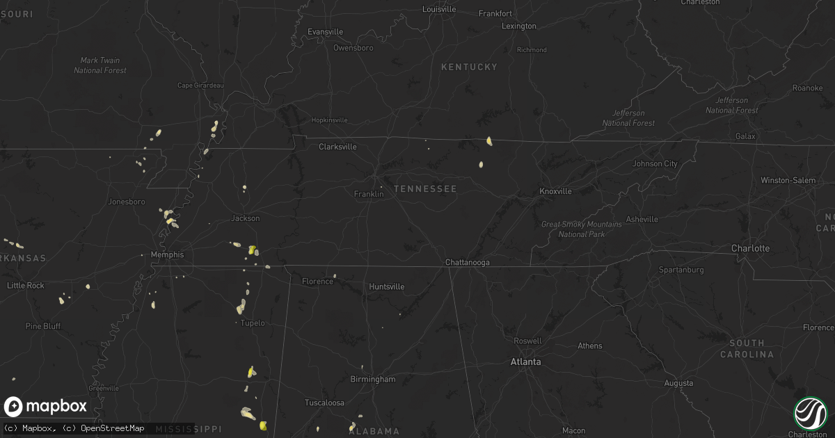
Hail Map in Tennessee on May 16, 2018
Get this storm
May 16 map
$229
one time, instant access
Download today. No call, no setup
Keep the $229
Bought the map and want the full workflow? Apply the entire $229 to a subscription within 7 days. None of it is wasted.
Every map, not just this one
This buys you this map. Subscription and you get every map we run, in the markets you choose from a few cities to whole states to nationwide. Plus real-time alerts the moment a storm fires.
Contact data
Name, contact info, occupancy, even credit band for addresses in the footprint. You go from where it hit to who to call.
Become the source they trust
Unlimited branding weather history reports on demand. You already have the documented answer ready for the property owner, and you are the one who showed up with it.
Property data and RoofTrace estimates
Pull up any address you have got, its value and the exact code rules for that jurisdiction, straight from One Click Code. Then RoofTrace estimates the squares, pitch, and roof value, priced the way you price.
Storm reports in Tennessee
Tennessee
| Date | Description |
|---|---|
| 05/16/20182:55 PM CDT | A local report indicates 1.00 inch wind near 4 E HORNSBY |
| 05/16/20182:27 PM CDT | Trained spotters report trees down and large limbs near highway 64. |
| 05/16/20181:02 AM CDT | At 602 PM CDT, a severe thunderstorm was located over Wilson, and is nearly stationary. HAZARD...60 mph wind gusts and quarter size hail. SOURCE...Radar indicated. IMPACT...Hail damage to vehicles is expected. Expect wind damage to roofs, siding, and trees. Locations impacted include... Wilson, Bassett, Fulton, Dixonville, Gilt Edge, Burlison, Delpro, Evadale, Driver, Grider, Golden Lake, Carson Lake, Rotan, Pecan Point, Drummonds, Norden, Randolph, Sans Souci and Hampson Archaeological Museum State Park. |
| 05/15/201811:42 PM CDT | At 442 PM CDT, a severe thunderstorm was located near Jennette, or 9 miles south of Earle, moving southeast at 10 mph. HAZARD...60 mph wind gusts and quarter size hail. SOURCE...Radar indicated. IMPACT...Hail damage to vehicles is expected. Expect wind damage to roofs, siding, and trees. Locations impacted include... West Memphis, Hughes, Edmondson, Anthonyville, Jennette, Simsboro, Crittenden, Kate, Browns, Louise, Jonquil, Brice, Amanea, Tarsus, Neuhardt, Democrat, North Hughes, Shearerville, Chatfield and Proctor. |
| 05/15/201810:39 PM CDT | At 339 PM CDT, a severe thunderstorm was located near Selmer, moving southeast at 15 mph. HAZARD...60 mph wind gusts and quarter size hail. SOURCE...Radar indicated. IMPACT...Hail damage to vehicles is expected. Expect wind damage to roofs, siding, and trees. Locations impacted include... Selmer, Big Hill Pond State Park, Adamsville, Bethel Springs, Eastview, Michie, Guys, Ramer, Stantonville, Good Hope, Pebble Hill, Tulu, Old Lawton, Acton, Purdy, Chewalla, Chambers, Hickory Flats, Mount Vinson and New Lawton. |
| 05/15/20189:57 PM CDT | At 257 PM CDT, a severe thunderstorm was located near Masseyville, or 9 miles south of Chickasaw State Forest, moving east at 30 mph. HAZARD...60 mph wind gusts and quarter size hail. SOURCE...Trained weather spotters. IMPACT...Hail damage to vehicles is expected. Expect wind damage to roofs, siding, and trees. Locations impacted include... Selmer, Big Hill Pond State Park, Adamsville, Silerton, Pocahontas, Masseyville, Robertson, McNairy, Bethel Springs, Middleton, Eastview, Michie, Guys, Ramer, Hornsby, Finger, Stantonville, Milledgeville, Saulsbury and Forty Forks. |
| 05/15/20189:31 PM CDT | At 230 PM CDT, a severe thunderstorm was located near Bolivar, moving east at 15 mph. HAZARD...60 mph wind gusts and quarter size hail. SOURCE...Radar indicated. IMPACT...Hail damage to vehicles is expected. Expect wind damage to roofs, siding, and trees. Locations impacted include... Bolivar, Silerton, Masseyville, Robertson, Toone, Hornsby, Rose Creek, Pine Top, Woodville, Lacy, Hickory Corners, Montezuma, Hebron, Van Buren and Shandy. |
All States Impacted by Hail Map on May 16, 2018
Cities Impacted by Hail Map on May 16, 2018
- Grenora, ND
- Humansville, MO
- Stockton, MO
- Gallion, AL
- Oark, AR
- Dover, AR
- Sturgis, SD
- Piedmont, SD
- Big Spring, TX
- Miami, TX
- Clarksville, AR
- Ozona, TX
- Louin, MS
- Lawrence, MS
- Pampa, TX
- Yerington, NV
- Wilson, AR
- Blue Springs, MS
- New Albany, MS
- Fort Gibson, OK
- Monticello, KY
- Brownsville, TN
- Calhoun, LA
- Farmington, AR
- Prairie Grove, AR
- Ward, AL
- Butler, AL
- Jachin, AL
- Church Point, LA
- Hattieville, AR
- Atkins, AR
- Osceola, AR
- Oktaha, OK
- Muskogee, OK
- Scooba, MS
- Shuqualak, MS
- Deadwood, SD
- Libby, MT
- Tiptonville, TN
- Charleston, AR
- Lavaca, AR
- Rapid City, SD
- Whitewood, SD
- Spearfish, SD
- Nemo, SD
- Greensboro, AL
- Sweet Water, AL
- Humnoke, AR
- Damascus, AR
- Springfield, AR
- Semmes, AL
- Canadian, TX
- Thomaston, AL
- Faunsdale, AL
- Catherine, AL
- Uniontown, AL
- Camden, AL
- Camden, AR
- Fairview, MT
- Heth, AR
- Pittsburg, KS
- Sterling City, TX
- Garden City, TX
- Barnhart, TX
- Mertzon, TX
- Moss Point, MS
- Lucedale, MS
- Rich Hill, MO
- Hume, MO
- Ponca City, OK
- Ozark, AR
- West Point, MS
- Republic, MO
- Clever, MO
- Billings, MO
- Twin Falls, ID
- Tunica, MS
- Theodore, AL
- Mobile, AL
- Ramer, TN
- Mena, AR
- Sledge, MS
- Foley, AL
- Havre, MT
- Garnett, KS
- Summersville, KY
- Magnolia, KY
- Shidler, OK
- Kaw City, OK
- Louisville, MS
- Macon, MS
- Richton, MS
- State Line, MS
- Leakesville, MS
- Neely, MS
- American Falls, ID
- Cecil, AR
- Broseley, MO
- Fisk, MO
- Toxey, AL
- Needham, AL
- Gilbertown, AL
- Chunchula, AL
- Wilmer, AL
- Eight Mile, AL
- Pocahontas, TN
- Selmer, TN
- Hornsby, TN
- Valentine, NE
- Greenbrier, AR
- Baileyville, KS
- Hettinger, ND
- Trenton, TN
- Centreville, AL
- Charleston, MO
- Tahlequah, OK
- Park Hill, OK
- Guntown, MS
- Wamego, KS
- Box Elder, MT
- Onaga, KS
- Cedarbluff, MS
- Starkville, MS
- Pall Mall, TN
- Aberdeen, ID
- Pocatello, ID
- Akron, AL
- Clarendon, AR
- Jay, FL
- Brewton, AL
- Flomaton, AL
- Century, FL
- Gulf Shores, AL
- Laurel, MS
- Pawnee City, NE
- Carbondale, IL
- Corinth, MS
- Michie, TN
- Crawford, TN
- Wilder, TN
- Hulbert, OK
- Bolivar, TN
- Henning, TN
- Drummonds, TN
- Hernando, MS
- Tompkinsville, KY
- Cleveland, AR
- Grand Bay, AL
- Irvington, AL
- Mountainburg, AR
- Glasgow, KY
- Keiser, AR
- Pocahontas, AR
- Maynard, AR
- Pompano Beach, FL
- Westmoreland, KS
- Preston, ID
- Vancleave, MS
- Centerton, AR
- Bentonville, AR
- Platte City, MO
- Kansas City, MO
- Nortonville, KS
- Memphis, TX
- Mulberry, AR
- Chester, AR
- Bethel Springs, TN
- Boise City, OK
- Citronelle, AL
- East Prairie, MO
- Brooksville, MS
- Tallulah, LA
- Greensburg, KY
- Felt, OK
- Huntsville, AR
- Wesley, AR
- Byhalia, MS
- Olive Branch, MS
- West Wendover, NV
- Knob Lick, KY
- Edmonton, KY
- Dyersburg, TN
- Sallisaw, OK
- Oden, AR
- Pencil Bluff, AR
- Brierfield, AL
- Jackson, AL
- Lakeview, TX
- Richards, MO
- Arkadelphia, AR
- Duson, LA
- Scott, LA
- Rayne, LA
- Little River, AL
- New Madrid, MO
- Lancaster, KS
- Saint Onge, SD
- Center, KY
- Raleigh, MS
- Springfield, MO
- Lafayette, TN
- Lafe, AR
- Milan, TN
- Pontotoc, MS
- Safford, AL
- Bay Springs, MS
- Stanberry, MO
- Vermillion, KS
- Hagarville, AR
- Ridgely, TN
- Belle Fourche, SD
- Nixa, MO
- Brookline, MO
- Rogers, AR
- Silas, AL
- Cartwright, ND
- Williston, ND
- Booneville, MS
- Ripley, MS
- Dumas, MS
- Rogersville, AL
- Killen, AL
- Malvern, AR
- Beaumont, MS
- Walker, MO
- Rector, AR
- Piggott, AR
- Antioch, TN
- Pollard, AR
- Asheboro, NC
- Ellisville, MS
- Marland, OK
- Austin, NV
- Canmer, KY
- Hardyville, KY
- Mount Sherman, KY
- Westville, OK
- Big Lake, TX
- Norman, AR
- Mount Ida, AR
- Cullman, AL
- Walnut, MS
- Boynton, OK
- Council Hill, OK
- Saraland, AL
- Middleton, TN
- Magazine, AR
- Havana, AR
- Effingham, KS
- Guntersville, AL
- Carlisle, AR
- Poplar Bluff, MO
- Qulin, MO
- Lamar, AR
- Forkland, AL
- Northport, WA
- Wagarville, AL
- Stuttgart, AR
- Golden Meadow, LA
- Linden, AL
- Danville, AR
- Hampton, AR
- Omaha, AR
- Knobel, AR
- Marmaduke, AR
- Royal, AR
- Graysville, AL
- Caddo Gap, AR
- Glenwood, AR
- Repton, AL
- Goff, KS
- Leroy, AL
- Saint Stephens, AL
- Willard, MO
- Center Ridge, AR
- Axtell, KS
- Kenton, OK
- Montello, NV
- Chinook, MT
- Baker, MT
- Ekalaka, MT
- Box Elder, SD


