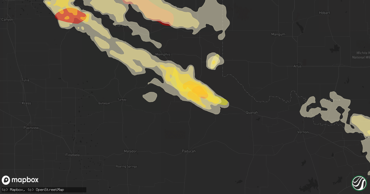
Hail Map in Childress, TX on May 16, 2016
Get this storm
May 16 map
$229
one time, instant access
Download today. No call, no setup
Keep the $229
Bought the map and want the full workflow? Apply the entire $229 to a subscription within 7 days. None of it is wasted.
Every map, not just this one
This buys you this map. Subscription and you get every map we run, in the markets you choose from a few cities to whole states to nationwide. Plus real-time alerts the moment a storm fires.
Contact data
Name, contact info, occupancy, even credit band for addresses in the footprint. You go from where it hit to who to call.
Become the source they trust
Unlimited branding weather history reports on demand. You already have the documented answer ready for the property owner, and you are the one who showed up with it.
Property data and RoofTrace estimates
Pull up any address you have got, its value and the exact code rules for that jurisdiction, straight from One Click Code. Then RoofTrace estimates the squares, pitch, and roof value, priced the way you price.
Storm reports in Childress, TX
Childress, TX
| Date | Description |
|---|---|
| 05/16/20161:45 AM CDT | A local report indicates 1.25 inch wind near CHILDRESS |
| 05/16/20161:35 AM CDT | Public web report of hail to the size of walnuts on the north side of childress. The report also mentioned the possibility of wind gusts to 60 mph. |
| 05/16/20161:33 AM CDT | Public report of hail to the size of quarter to half dollar in diameter in childress. Report relayed to nws by kvii tv amarillo. |
| 05/16/20161:30 AM CDT | Hail to golfball size in diameter reported at the chilress county sherrifs office. |
All Cities Impacted by Hail Map on May 16, 2016
- Cactus, TX
- Stratford, TX
- Dumas, TX
- Butler, OK
- Iowa Park, TX
- Burkburnett, TX
- Dalhart, TX
- Perryton, TX
- Wellington, TX
- Quail, TX
- Memphis, TX
- Lakeview, TX
- Spearman, TX
- Frederick, OK
- Stinnett, TX
- Borger, TX
- Morse, TX
- Pampa, TX
- Clarendon, TX
- Wichita Falls, TX
- Randlett, OK
- Channing, TX
- Canadian, TX
- Durham, OK
- Crawford, OK
- Cheyenne, OK
- Reydon, OK
- Sayre, OK
- Grandfield, OK
- Devol, OK
- Paducah, TX
- Childress, TX
- Amarillo, TX
- Clayton, NM
- Grenville, NM
- Kenton, OK
- Felt, OK
- Boise City, OK
- Sheppard Afb, TX
- Loveland, OK
- Gruver, TX
- Sunray, TX
- Erick, OK
- Hollis, OK
- Miami, TX
- Groom, TX
- White Deer, TX
- Goodwell, OK
- Panhandle, TX
- Mangum, OK
- Briscoe, TX
- Dodson, TX
- Claude, TX
- Petrolia, TX
- Tipton, OK
- Vernon, TX
- Davidson, OK
- Hollister, OK
- Elmer, OK
- Electra, TX
- Watonga, OK
- Quanah, TX
- Texline, TX
- Kim, CO
- Mclean, TX
- Plains, KS
- Meade, KS
- Shamrock, TX
- Sentinel, OK
- Carter, OK
- Elk City, OK
- Masterson, TX
- Taloga, OK
- Hedley, TX
- Lelia Lake, TX
- Leedey, OK
- Arnett, OK
- Fay, OK
- Sweetwater, OK
- Garden City, KS
- Oakwood, OK
- Okeene, OK
- Des Moines, NM
- Blair, OK
- Harrold, TX
- Turkey, TX
- Fowler, KS
- Vici, OK
- Cee Vee, TX
- Hammon, OK
- Folsom, NM
- Sedan, NM
- Dill City, OK
- Canute, OK
- Cordell, OK
- Homestead, FL
- Matador, TX
- Iraan, TX
- Hartley, TX
- Wheeler, TX


