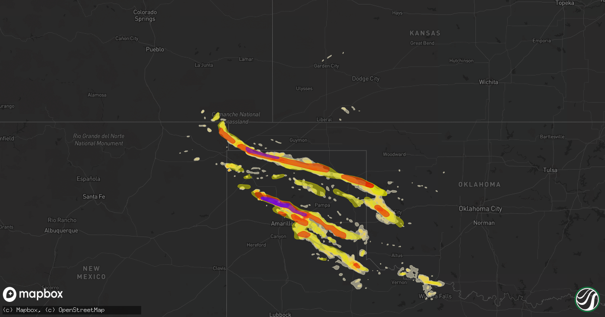
Hail Map on May 16, 2016
Get this storm
May 16 map
$229
one time, instant access
Download today. No call, no setup
Keep the $229
Bought the map and want the full workflow? Apply the entire $229 to a subscription within 7 days. None of it is wasted.
Every map, not just this one
This buys you this map. Subscription and you get every map we run, in the markets you choose from a few cities to whole states to nationwide. Plus real-time alerts the moment a storm fires.
Contact data
Name, contact info, occupancy, even credit band for addresses in the footprint. You go from where it hit to who to call.
Become the source they trust
Unlimited branding weather history reports on demand. You already have the documented answer ready for the property owner, and you are the one who showed up with it.
Property data and RoofTrace estimates
Pull up any address you have got, its value and the exact code rules for that jurisdiction, straight from One Click Code. Then RoofTrace estimates the squares, pitch, and roof value, priced the way you price.
Storm reports
Texas
| Date | Description |
|---|---|
| 05/16/20166:56 PM CDT | Measured with a ruler |
| 05/16/20166:49 PM CDT | A local report indicates 1.00 inch wind near 6 SW DALHART |
| 05/16/20166:48 PM CDT | A local report indicates 1.75 inch wind near 11 S TEXHOMA |
| 05/16/20166:46 PM CDT | A local report indicates 1.00 inch wind near 16 E STRATFORD |
| 05/16/20166:30 PM CDT | Golf ball size hail reported in stratford as storm moved through. |
| 05/16/20166:20 PM CDT | A local report indicates 1.00 inch wind near STRATFORD |
| 05/16/20166:06 PM CDT | Based on storm survey - tornado start time 606 pm cdt / end time 607 pm cdt |
| 05/16/20165:40 PM CDT | Based on storm survey - tornado start time 540 pm cdt / end time 542 pm cdt |
| 05/16/20165:40 PM CDT | Grain bend damaged and pivots flipped near sh102 and mcadams. |
| 05/16/20165:35 PM CDT | Facebook photo of golf ball sized hail. Time estimated from doppler radar. |
| 05/16/20165:31 PM CDT | A local report indicates a tornado near 30 N DALHART |
| 05/16/20165:30 PM CDT | Storm chaser reports hen egg sized hail on highway 385 near the oklahoma state line |
| 05/16/20164:50 PM CDT | A local report indicates 63 MPH wind near 15 WSW WARE |
| 05/16/20161:45 AM CDT | A local report indicates 1.25 inch wind near CHILDRESS |
| 05/16/20161:35 AM CDT | Public web report of hail to the size of walnuts on the north side of childress. The report also mentioned the possibility of wind gusts to 60 mph. |
| 05/16/20161:33 AM CDT | Public report of hail to the size of quarter to half dollar in diameter in childress. Report relayed to nws by kvii tv amarillo. |
| 05/16/20161:30 AM CDT | Hail to golfball size in diameter reported at the chilress county sherrifs office. |
| 05/16/201612:14 AM CDT | County judge had received report of quarter sized hail in lutie. Time estimated from doppler radar. |
| 05/15/201611:25 PM CDT | Quarter sized hail up to 2 inches deep...2.50 inches of rain fell in 25 minutes...flood in area to include across texas highway 273. Time estimated from doppler radar. |
| 05/15/201610:54 PM CDT | Police deputy reported quarter sized hail fell with storm that passed over the town. No hail damage to report. Time estimated from doppler radar. |
| 05/15/201610:32 PM CDT | Quarter size hail was falling northwest of goodnight. |
| 05/15/201610:17 PM CDT | Hail to the size of half dollars was accumulating on roadways along with standing water 6 miles e of conway near interstate 40. |
| 05/15/201610:07 PM CDT | Ping pong ball size hail was reported along us highway 60. |
| 05/15/20169:57 PM CDT | Hail up to the size of golf balls was found along us highway 60 near county road j southwest of panhandle. Time estimated from radar. |
| 05/15/20169:56 PM CDT | Measured by handheld wind device. |
| 05/15/20169:50 PM CDT | Hail to the size of tennis balls was falling east of panhandle with some flooding of rural roads also reported. |
| 05/15/20169:45 PM CDT | Hail to the size of golf balls and 52 mph wind gusts reported at pantex. |
| 05/15/20169:35 PM CDT | Relayed via broadcast media from viewer. |
| 05/15/20169:28 PM CDT | Multiple tree limbs about 6 inches in diameter in roadway along us highway 83. |
| 05/15/20169:25 PM CDT | A tornado was reported near the oklahoma state line north of tx highway 33 and near the canadian river. Location estimated from radar. |
| 05/15/20169:19 PM CDT | Trees uprooted near fm 2266 approximately 10 miles se of canadian with an intermittent tornado. |
| 05/15/20169:15 PM CDT | Hail to the size of golf balls fell along us highway 87. |
| 05/15/20169:10 PM CDT | A local report indicates 74 MPH wind near 6 E CANADIAN |
| 05/15/20169:10 PM CDT | Strong gust front ahead of storm brought 70 mph winds. Time estimated from doppler radar |
| 05/15/20169:06 PM CDT | Based on spotter/chaser reports and storm survey... Tornado start time 0906 pm / end time 0925 pm. Several trees were uprooted in gene howe wma and near fm 2266 with a |
| 05/15/20169:06 PM CDT | Several trees were uprooted in gene howe wma with a reported tornado. |
| 05/15/20168:57 PM CDT | Pictures received of downed tree in canadian. Time estimated from doppler radar. |
| 05/15/20168:52 PM CDT | Based on storm survey - tornado start time 852 pm cdt / end time 853 pm cdt |
| 05/15/20168:51 PM CDT | A local report indicates 2.75 inch wind near 6 S MASTERSON |
| 05/15/20168:45 PM CDT | Also estimated 60 mph wind gusts. |
| 05/15/20168:40 PM CDT | Hail up to 3 inches in diameter fell south of masterson along us highway 87. |
| 05/15/20168:40 PM CDT | Tennis ball size hail was reported south of masterson along us highway 87. |
| 05/15/20168:36 PM CDT | A local report indicates 2.50 inch wind near 6 SSE MASTERSON |
| 05/15/20168:36 PM CDT | A local report indicates 2.00 inch wind near 8 SSE MASTERSON |
| 05/15/20168:33 PM CDT | Hail up to 3 inches damaged windshields of vehicles in marsh on highway 87. |
| 05/15/20168:31 PM CDT | A local report indicates 2.50 inch wind near 3 S MASTERSON |
| 05/15/20168:30 PM CDT | A local report indicates 1.00 inch wind near MASTERSON |
| 05/15/20168:27 PM CDT | Small structure damaged at the intersection of tx highway 70 and fm 281. |
| 05/15/20168:22 PM CDT | A local report indicates 1.00 inch wind near 1 N MASTERSON |
| 05/15/20168:17 PM CDT | Debris blowing across roadway on highway 281. |
| 05/15/20168:05 PM CDT | Quarter size hail and estimated 55 to 60 mph wind gusts were reported north of stinnett along tx highway 136. |
| 05/15/20168:05 PM CDT | A local report indicates 1.75 inch wind near 5 ENE CHANNING |
| 05/15/20168:05 PM CDT | Quarter size hail and estimated 55 to 60 mph wind gusts were reported north of stinnett along tx highway 136. |
| 05/15/20168:02 PM CDT | A local report indicates 70 MPH wind near 7 E SPEARMAN |
| 05/15/20168:02 PM CDT | A local report indicates 70 MPH wind near 25 SSW PERRYTON |
| 05/15/20168:02 PM CDT | A local report indicates 1.00 inch wind near 7 E SPEARMAN |
| 05/15/20168:02 PM CDT | A local report indicates 1.00 inch wind near 25 E PERRYTON |
| 05/15/20168:02 PM CDT | A local report indicates 1.00 inch wind near 25 SSW PERRYTON |
| 05/15/20168:00 PM CDT | Storm chaser reported 3 power poles snapped. |
| 05/15/20167:58 PM CDT | A local report indicates 1.75 inch wind near 6 ENE CHANNING |
| 05/15/20167:55 PM CDT | A local report indicates 1.50 inch wind near 1 E CHANNING |
| 05/15/20167:50 PM CDT | Tv media chaser reported golfball hail from 3 west to channing to west side of channing |
| 05/15/20167:43 PM CDT | A local report indicates 1.50 inch wind near 3 NE SPEARMAN |
| 05/15/20167:43 PM CDT | Storm chaser reported 3 power poles snapped. |
| 05/15/20167:40 PM CDT | Measured at gruver schoolnet site. |
| 05/15/20167:40 PM CDT | A local report indicates 1.00 inch wind near SPEARMAN |
| 05/15/20167:35 PM CDT | Time estimated from doppler radar. |
| 05/15/20167:22 PM CDT | A local report indicates 62 MPH wind near GRUVER |
| 05/15/20167:17 PM CDT | Pea size hail also reported from this location |
| 05/15/20167:16 PM CDT | Hail reported to be covering highway 281 east out of catus. |
| 05/15/20167:11 PM CDT | A local report indicates 1.00 inch wind near 1 SSW CACTUS |
Oklahoma
| Date | Description |
|---|---|
| 05/16/20165:05 PM CDT | Cimarron county sheriff office reports golfball sized hail. 60 mph wind gusts and heavy rain producing muddy roads |
| 05/16/20165:05 PM CDT | Cimarron county sheriff office reports golfball sized hail. 60 mph wind gusts and heavy rain producing muddy roads |
| 05/16/20165:01 PM CDT | A local report indicates 1.00 inch wind near FELT |
| 05/16/20164:57 PM CDT | Second tornado reported by multiple storm chasers |
| 05/16/20164:39 PM CDT | Tornado reported by several storm chasers |
| 05/16/20163:59 PM CDT | A local report indicates 1.00 inch wind near 5 W WHEELESS |
| 05/16/201612:35 PM CDT | A local report indicates 68 MPH wind near 2 W CYRIL |
| 05/16/20169:37 AM CDT | Reported near durham. |
| 05/16/201612:54 AM CDT | A local report indicates 69 MPH wind near 3 N THE VILLAGE |
| 05/16/201612:45 AM CDT | Small tree limbs around 2 inches in diamter down. |
| 05/16/201612:05 AM CDT | A local report indicates 1.00 inch wind near 12 NW OKARCHE |
| 05/15/201611:35 PM CDT | A local report indicates 66 MPH wind near 4 SE HOBART |
| 05/15/201611:32 PM CDT | A local report indicates 67 MPH wind near 3 SE HOBART |
| 05/15/201611:30 PM CDT | A local report indicates 72 MPH wind near 4 WSW WEATHERFORD |
| 05/15/201611:30 PM CDT | A local report indicates 65 MPH wind near 4 SE HOBART |
| 05/15/201611:25 PM CDT | A local report indicates 60 MPH wind near 3 NE CLINTON |
| 05/15/201610:50 PM CDT | From oklahoma mesonet site. |
| 05/15/201610:31 PM CDT | Power lines down |
| 05/15/201610:30 PM CDT | A local report indicates 1.25 inch wind near 12 SSE CHEYENNE |
| 05/15/201610:30 PM CDT | Six to eight inch diameter tree branches broken along highway 33. |
| 05/15/201610:29 PM CDT | A local report indicates 1.25 inch wind near 4 E DEMPSEY |
| 05/15/201610:26 PM CDT | A local report indicates 1.25 inch wind near 2 E DEMPSEY |
| 05/15/201610:24 PM CDT | A local report indicates 1.00 inch wind near 6 E SWEETWATER |
| 05/15/201610:22 PM CDT | A local report indicates 1.75 inch wind near 8 NNW SAYRE |
| 05/15/201610:20 PM CDT | A local report indicates 1.75 inch wind near 13 W ELK CITY |
| 05/15/201610:15 PM CDT | A local report indicates 1.00 inch wind near 3 W DEMPSEY |
| 05/15/201610:07 PM CDT | A local report indicates 1.25 inch wind near 2 N STRONG CITY |
| 05/15/20169:53 PM CDT | A local report indicates 1.25 inch wind near 6 SW CRAWFORD |
| 05/15/20169:42 PM CDT | A local report indicates 1.00 inch wind near DURHAM |
| 05/15/20169:37 PM CDT | Reported near durham. Corrected for time. |
| 05/15/20167:25 PM CDT | A local report indicates 60 MPH wind near 2 E GOODWELL |
| 05/15/20167:17 PM CDT | A local report indicates 65 MPH wind near GOODWELL |
| 05/15/20167:15 PM CDT | A local report indicates 62 MPH wind near GOODWELL |
| 05/15/20167:10 PM CDT | A local report indicates 70 MPH wind near GOODWELL |
| 05/15/20167:04 PM CDT | A local report indicates 62 MPH wind near GOODWELL |
New Mexico
| Date | Description |
|---|---|
| 05/16/20163:49 PM CDT | A local report indicates 1.25 inch wind near 4 NNE MOSES |
| 05/16/20163:05 PM CDT | Up to quarter sized hail also reported covering nm406 north of seneca. |
| 05/16/20162:39 PM CDT | A local report indicates 1.00 inch wind near 11 N MOSES |
| 05/15/20167:15 PM CDT | Kaxx awos. |
Cities Impacted by Hail Map on May 16, 2016
- Cactus, TX
- Stratford, TX
- Dumas, TX
- Butler, OK
- Iowa Park, TX
- Burkburnett, TX
- Dalhart, TX
- Perryton, TX
- Wellington, TX
- Quail, TX
- Memphis, TX
- Lakeview, TX
- Spearman, TX
- Frederick, OK
- Stinnett, TX
- Borger, TX
- Morse, TX
- Pampa, TX
- Clarendon, TX
- Wichita Falls, TX
- Randlett, OK
- Channing, TX
- Canadian, TX
- Durham, OK
- Crawford, OK
- Cheyenne, OK
- Reydon, OK
- Sayre, OK
- Grandfield, OK
- Devol, OK
- Paducah, TX
- Childress, TX
- Amarillo, TX
- Clayton, NM
- Grenville, NM
- Kenton, OK
- Felt, OK
- Boise City, OK
- Sheppard Afb, TX
- Loveland, OK
- Gruver, TX
- Sunray, TX
- Erick, OK
- Hollis, OK
- Miami, TX
- Groom, TX
- White Deer, TX
- Goodwell, OK
- Panhandle, TX
- Mangum, OK
- Briscoe, TX
- Dodson, TX
- Claude, TX
- Petrolia, TX
- Tipton, OK
- Vernon, TX
- Davidson, OK
- Hollister, OK
- Elmer, OK
- Electra, TX
- Watonga, OK
- Quanah, TX
- Texline, TX
- Kim, CO
- Mclean, TX
- Plains, KS
- Meade, KS
- Shamrock, TX
- Sentinel, OK
- Carter, OK
- Elk City, OK
- Masterson, TX
- Taloga, OK
- Hedley, TX
- Lelia Lake, TX
- Leedey, OK
- Arnett, OK
- Fay, OK
- Sweetwater, OK
- Garden City, KS
- Oakwood, OK
- Okeene, OK
- Des Moines, NM
- Blair, OK
- Harrold, TX
- Turkey, TX
- Fowler, KS
- Vici, OK
- Cee Vee, TX
- Hammon, OK
- Folsom, NM
- Sedan, NM
- Dill City, OK
- Canute, OK
- Cordell, OK
- Homestead, FL
- Matador, TX
- Iraan, TX
- Hartley, TX
- Wheeler, TX