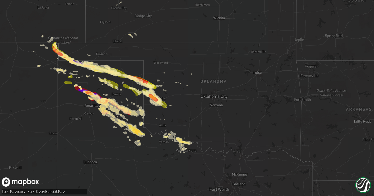
Hail Map in Oklahoma on May 16, 2016
Get this storm
May 16 map
$229
one time, instant access
Download today. No call, no setup
Keep the $229
Bought the map and want the full workflow? Apply the entire $229 to a subscription within 7 days. None of it is wasted.
Every map, not just this one
This buys you this map. Subscription and you get every map we run, in the markets you choose from a few cities to whole states to nationwide. Plus real-time alerts the moment a storm fires.
Contact data
Name, contact info, occupancy, even credit band for addresses in the footprint. You go from where it hit to who to call.
Become the source they trust
Unlimited branding weather history reports on demand. You already have the documented answer ready for the property owner, and you are the one who showed up with it.
Property data and RoofTrace estimates
Pull up any address you have got, its value and the exact code rules for that jurisdiction, straight from One Click Code. Then RoofTrace estimates the squares, pitch, and roof value, priced the way you price.
Storm reports in Oklahoma
Oklahoma
| Date | Description |
|---|---|
| 05/16/20165:05 PM CDT | Cimarron county sheriff office reports golfball sized hail. 60 mph wind gusts and heavy rain producing muddy roads |
| 05/16/20165:05 PM CDT | Cimarron county sheriff office reports golfball sized hail. 60 mph wind gusts and heavy rain producing muddy roads |
| 05/16/20165:01 PM CDT | A local report indicates 1.00 inch wind near FELT |
| 05/16/20164:57 PM CDT | Second tornado reported by multiple storm chasers |
| 05/16/20164:39 PM CDT | Tornado reported by several storm chasers |
| 05/16/20163:59 PM CDT | A local report indicates 1.00 inch wind near 5 W WHEELESS |
| 05/16/201612:35 PM CDT | A local report indicates 68 MPH wind near 2 W CYRIL |
| 05/16/20169:37 AM CDT | Reported near durham. |
| 05/16/201612:54 AM CDT | A local report indicates 69 MPH wind near 3 N THE VILLAGE |
| 05/16/201612:45 AM CDT | Small tree limbs around 2 inches in diamter down. |
| 05/16/201612:05 AM CDT | A local report indicates 1.00 inch wind near 12 NW OKARCHE |
| 05/15/201611:35 PM CDT | A local report indicates 66 MPH wind near 4 SE HOBART |
| 05/15/201611:32 PM CDT | A local report indicates 67 MPH wind near 3 SE HOBART |
| 05/15/201611:30 PM CDT | A local report indicates 72 MPH wind near 4 WSW WEATHERFORD |
| 05/15/201611:30 PM CDT | A local report indicates 65 MPH wind near 4 SE HOBART |
| 05/15/201611:25 PM CDT | A local report indicates 60 MPH wind near 3 NE CLINTON |
| 05/15/201610:50 PM CDT | From oklahoma mesonet site. |
| 05/15/201610:31 PM CDT | Power lines down |
| 05/15/201610:30 PM CDT | A local report indicates 1.25 inch wind near 12 SSE CHEYENNE |
| 05/15/201610:30 PM CDT | Six to eight inch diameter tree branches broken along highway 33. |
| 05/15/201610:29 PM CDT | A local report indicates 1.25 inch wind near 4 E DEMPSEY |
| 05/15/201610:26 PM CDT | A local report indicates 1.25 inch wind near 2 E DEMPSEY |
| 05/15/201610:24 PM CDT | A local report indicates 1.00 inch wind near 6 E SWEETWATER |
| 05/15/201610:22 PM CDT | A local report indicates 1.75 inch wind near 8 NNW SAYRE |
| 05/15/201610:20 PM CDT | A local report indicates 1.75 inch wind near 13 W ELK CITY |
| 05/15/201610:15 PM CDT | A local report indicates 1.00 inch wind near 3 W DEMPSEY |
| 05/15/201610:07 PM CDT | A local report indicates 1.25 inch wind near 2 N STRONG CITY |
| 05/15/20169:53 PM CDT | A local report indicates 1.25 inch wind near 6 SW CRAWFORD |
| 05/15/20169:42 PM CDT | A local report indicates 1.00 inch wind near DURHAM |
| 05/15/20169:37 PM CDT | Reported near durham. Corrected for time. |
| 05/15/20167:25 PM CDT | A local report indicates 60 MPH wind near 2 E GOODWELL |
| 05/15/20167:17 PM CDT | A local report indicates 65 MPH wind near GOODWELL |
| 05/15/20167:15 PM CDT | A local report indicates 62 MPH wind near GOODWELL |
| 05/15/20167:10 PM CDT | A local report indicates 70 MPH wind near GOODWELL |
| 05/15/20167:04 PM CDT | A local report indicates 62 MPH wind near GOODWELL |
Cities Impacted by Hail Map on May 16, 2016
- Cactus, TX
- Stratford, TX
- Dumas, TX
- Butler, OK
- Iowa Park, TX
- Burkburnett, TX
- Dalhart, TX
- Perryton, TX
- Wellington, TX
- Quail, TX
- Memphis, TX
- Lakeview, TX
- Spearman, TX
- Frederick, OK
- Stinnett, TX
- Borger, TX
- Morse, TX
- Pampa, TX
- Clarendon, TX
- Wichita Falls, TX
- Randlett, OK
- Channing, TX
- Canadian, TX
- Durham, OK
- Crawford, OK
- Cheyenne, OK
- Reydon, OK
- Sayre, OK
- Grandfield, OK
- Devol, OK
- Paducah, TX
- Childress, TX
- Amarillo, TX
- Clayton, NM
- Grenville, NM
- Kenton, OK
- Felt, OK
- Boise City, OK
- Sheppard Afb, TX
- Loveland, OK
- Gruver, TX
- Sunray, TX
- Erick, OK
- Hollis, OK
- Miami, TX
- Groom, TX
- White Deer, TX
- Goodwell, OK
- Panhandle, TX
- Mangum, OK
- Briscoe, TX
- Dodson, TX
- Claude, TX
- Petrolia, TX
- Tipton, OK
- Vernon, TX
- Davidson, OK
- Hollister, OK
- Elmer, OK
- Electra, TX
- Watonga, OK
- Quanah, TX
- Texline, TX
- Kim, CO
- Mclean, TX
- Plains, KS
- Meade, KS
- Shamrock, TX
- Sentinel, OK
- Carter, OK
- Elk City, OK
- Masterson, TX
- Taloga, OK
- Hedley, TX
- Lelia Lake, TX
- Leedey, OK
- Arnett, OK
- Fay, OK
- Sweetwater, OK
- Garden City, KS
- Oakwood, OK
- Okeene, OK
- Des Moines, NM
- Blair, OK
- Harrold, TX
- Turkey, TX
- Fowler, KS
- Vici, OK
- Cee Vee, TX
- Hammon, OK
- Folsom, NM
- Sedan, NM
- Dill City, OK
- Canute, OK
- Cordell, OK
- Homestead, FL
- Matador, TX
- Iraan, TX
- Hartley, TX
- Wheeler, TX


