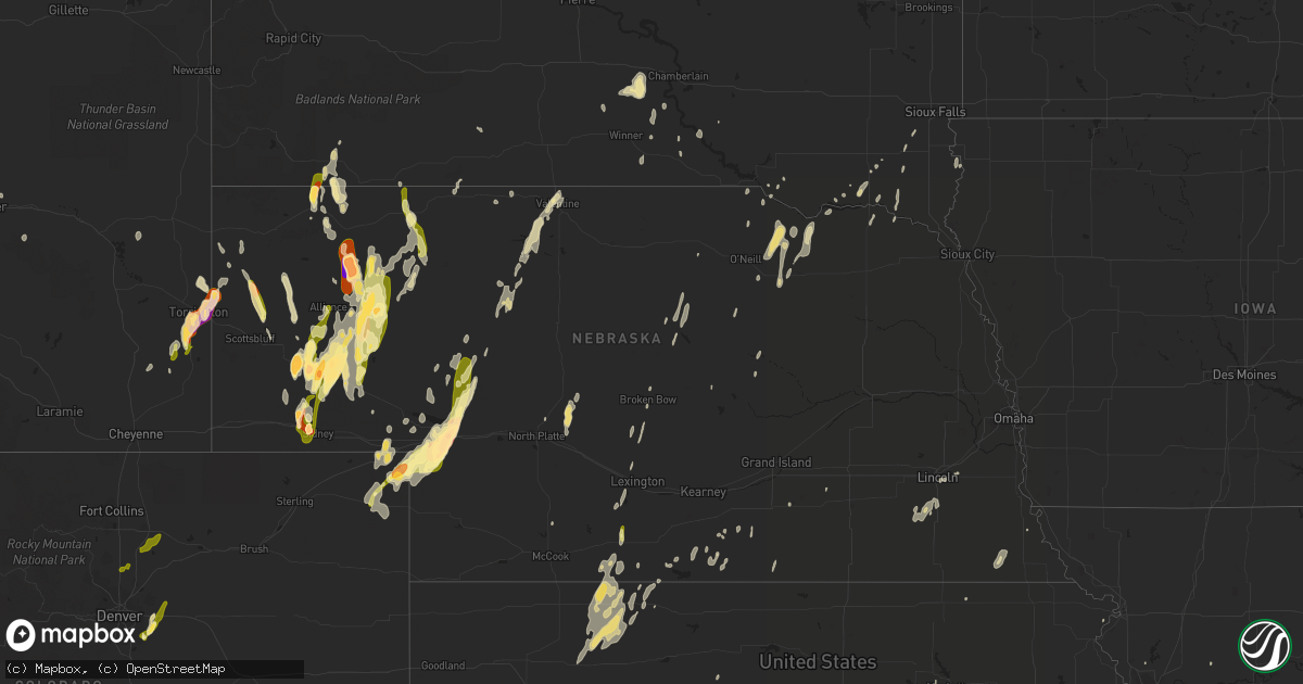
Hail Map in Nebraska on May 15, 2015
Get this storm
May 15 map
$229
one time, instant access
Download today. No call, no setup
Keep the $229
Bought the map and want the full workflow? Apply the entire $229 to a subscription within 7 days. None of it is wasted.
Every map, not just this one
This buys you this map. Subscription and you get every map we run, in the markets you choose from a few cities to whole states to nationwide. Plus real-time alerts the moment a storm fires.
Contact data
Name, contact info, occupancy, even credit band for addresses in the footprint. You go from where it hit to who to call.
Become the source they trust
Unlimited branding weather history reports on demand. You already have the documented answer ready for the property owner, and you are the one who showed up with it.
Property data and RoofTrace estimates
Pull up any address you have got, its value and the exact code rules for that jurisdiction, straight from One Click Code. Then RoofTrace estimates the squares, pitch, and roof value, priced the way you price.
Storm reports in Nebraska
Nebraska
| Date | Description |
|---|---|
| 05/15/20156:45 PM CDT | Quarter to golfball size hail. |
| 05/15/20156:42 PM CDT | Marble to quarter size hail with very heavy rain. |
| 05/15/20156:32 PM CDT | A local report indicates 1.75 inch wind near 4 W BRIDGEPORT |
| 05/15/20156:25 PM CDT | Moved a picnic table 20 feet and destroyed it. |
| 05/15/20156:20 PM CDT | Hail ranged from golf ball to baseball size |
| 05/15/20156:15 PM CDT | A local report indicates 1.00 inch wind near 5 NNE LISCO |
| 05/15/20156:01 PM CDT | Quarter to hen egg size hail. |
| 05/15/20155:52 PM CDT | Dime to quarter size hail. |
| 05/15/20154:45 PM CDT | A local report indicates 1.25 inch wind near BRIDGEPORT |
| 05/15/20154:35 PM CDT | Significant damage to vehicles. |
| 05/15/20153:40 PM CDT | A local report indicates 1.25 inch wind near 10 N BROWNSON |
| 05/15/20153:38 PM CDT | A local report indicates 1.00 inch wind near 9 W GURLEY |
| 05/15/20153:30 PM CDT | Ping-pong to golf-ball sized hail reported. |
| 05/14/201510:16 PM CDT | A local report indicates 1.50 inch wind near ROSCOE |
| 05/14/201510:10 PM CDT | A local report indicates 1.00 inch wind near 6 E ARTHUR |
| 05/14/20159:50 PM CDT | 60 mph winds reported as well |
| 05/14/20159:41 PM CDT | A local report indicates 1.75 inch wind near 1 SSE OGALLALA |
| 05/14/20159:39 PM CDT | Estimated wind speeds of 60 to 70 mph |
| 05/14/20159:24 PM CDT | A local report indicates 1.75 inch wind near 8 N GRANT |
| 05/14/20159:18 PM CDT | A local report indicates 1.00 inch wind near 5 W GRANT |
| 05/14/20159:15 PM CDT | Estimated 50 to 60 mph winds |
| 05/14/20159:08 PM CDT | Rushville volunteer fire and rescue reported tornado touched down 1.5 miles south of rushville near 808 pm mdt. The tornado moved north before lifting at 0810 pm mdt. N |
| 05/14/20159:08 PM CDT | Rushville volunteer fire and rescue reported tornado touched down near 0808 pm mdt...and moved north and lifted at 0810 pm mdt. No damage reported. |
| 05/14/20159:00 PM CDT | Estimated time of 900pm cdt |
| 05/14/20159:00 PM CDT | Estimated time of 900pm cdt |
| 05/14/20158:57 PM CDT | Wind speeds estimated at 50 to 60 mph |
| 05/14/20158:55 PM CDT | A local report indicates 1.00 inch wind near 5 NW ELLSWORTH |
| 05/14/20158:48 PM CDT | 5 miles north of arapahoe quarter size hail fell from 848 to 854 pm. |
| 05/14/20158:34 PM CDT | Tornado confirmed by chasers at 734 mdt. |
| 05/14/20158:32 PM CDT | A local report indicates 1.00 inch wind near 5 E GORDON |
| 05/14/20158:30 PM CDT | A local report indicates 1.00 inch wind near 5 N VENANGO |
| 05/14/20157:28 PM CDT | Mostly pea to nickel size hail with largest golfball. |
| 05/14/20157:15 PM CDT | A local report indicates 1.75 inch wind near 7 E ANTIOCH |
All States Impacted by Hail Map on May 15, 2015
Cities Impacted by Hail Map on May 15, 2015
- Merriman, NE
- Gordon, NE
- Mooreland, OK
- Fayette, MO
- Higbee, MO
- Boonville, MO
- Jal, NM
- Loose Creek, MO
- Linn, MO
- Chadron, NE
- Hammon, OK
- Grant, NE
- Ogallala, NE
- Keystone, NE
- Brule, NE
- Chester, OK
- Lovington, NM
- Pine Ridge, SD
- Mcdonald, NM
- Lentner, MO
- Shelbyville, MO
- Clarence, MO
- Elida, NM
- Pep, NM
- Portage Des Sioux, MO
- Oneill, NE
- Wildersville, TN
- Morton, TX
- Sudan, TX
- Muleshoe, TX
- Maple, TX
- Oshkosh, NE
- Lakeside, NE
- Ellsworth, NE
- Terre Haute, IN
- Hay Springs, NE
- Robinsonville, MS
- Tunica, MS
- Farwell, TX
- Santa Fe, MO
- Paris, MO
- Julesburg, CO
- Fargo, OK
- Versailles, MO
- Seagraves, TX
- Buffalo, OK
- House, NM
- Fort Sumner, NM
- Long Valley, SD
- Gruver, TX
- Minatare, NE
- Hemingford, NE
- Alliance, NE
- Harrison, NE
- Marsland, NE
- Valentine, NE
- Sidney, NE
- Doniphan, MO
- Marshall, MO
- Glasgow, MO
- Nelson, MO
- Franklin, MO
- Slater, MO
- Utica, SD
- Yankton, SD
- Bridgeport, NE
- Arnett, OK
- Gage, OK
- Lenora, KS
- Jerseyville, IL
- Grafton, IL
- Whitman, NE
- Hattieville, AR
- Amherst, CO
- Venango, NE
- Sutherland, NE
- Paxton, NE
- Arthur, NE
- Jefferson City, MO
- Taiban, NM
- Chappell, NE
- Stinnett, TX
- Lake Cormorant, MS
- Stuart, NE
- Montgomery, AL
- Bayard, NE
- Crenshaw, MS
- Saint Petersburg, FL
- Happy, TX
- Angora, NE
- Lisco, NE
- Broadwater, NE
- Spearman, TX
- Wathena, KS
- Reliance, SD
- Kennebec, SD
- Hamill, SD
- Arnold, NE
- Brady, NE
- Stapleton, NE
- Maxwell, NE
- Norcatur, KS
- Norton, KS
- Pilot Grove, MO
- Uriah, AL
- Colome, SD
- Aurora, CO
- Parker, CO
- Olaton, KY
- Beaver Dam, KY
- Hartford, KY
- Wynne, AR
- Cherry Valley, AR
- Oakwood, IL
- Fithian, IL
- Sharon, OK
- Mcalister, NM
- Tucumcari, NM
- Pinellas Park, FL
- Vermillion, SD
- Volin, SD
- Gayville, SD
- Wakonda, SD
- Taylor, NE
- Causey, NM
- Wagner, SD
- Spalding, NE
- Greeley, NE
- Russell, KS
- Table Rock, NE
- Smithville, MO
- Manville, WY
- Oaktown, IN
- Lynch, NE
- Verdigre, NE
- Ewing, NE
- Orchard, NE
- Page, NE
- Bertrand, MO
- Sikeston, MO
- Wilber, NE
- Clatonia, NE
- Crete, NE
- Hallam, NE
- Martell, NE
- Roca, NE
- Sprague, NE
- Claude, TX
- Holstein, NE
- Campbell, NE
- Minden, NE
- Mount Olive, IL
- Carlisle, IN
- Franklin, NE
- Marble Hill, MO
- Anabel, MO
- Marks, MS
- Irene, SD
- Sunrise Beach, MO
- Crofton, NE
- Fordyce, NE
- Saint Helena, NE
- Torrington, WY
- Robertsville, MO
- Vinson, OK
- Tatum, NM
- Patton, MO
- Shelbina, MO
- Rosedale, IN
- Rogers, NM
- Bristow, IN
- Birdseye, IN
- Morrill, NE
- Alma, NE
- Orleans, NE
- Wilmington, OH
- Burwell, NE
- Copeland, KS
- Turpin, OK
- Ashby, NE
- Hawk Springs, WY
- Borger, TX
- Olney, IL
- Hurley, SD
- Davis, SD
- Perryton, TX
- Lesterville, SD
- Sayre, OK
- Saint Francisville, LA
- Haxtun, CO
- Elwood, NE
- Pecos, TX
- Balmorhea, TX
- Blairstown, MO
- Cisne, IL
- Mount Erie, IL
- Roseland, NE
- Bladen, NE
- Arapahoe, NE
- Malta Bend, MO
- Lexington, NE
- Broken Bow, NE
- Lincoln, NE
- Rushville, NE
- Watkins, CO
- Andrews, TX
- Eunice, NM
- Bloomington, NE
- Hildreth, NE
- Columbia, IL
- Barlow, KY
- Cairo, IL
- Villa Ridge, IL
- Olmsted, IL
- Sledge, MS
- Powell, WY
- Ovid, CO
- Burke, SD
- La Plata, MO
- Stendal, IN
- Huntingburg, IN
- Rhineland, MO
- Hermann, MO
- Mutual, OK
- Mullen, NE
- Lorenzo, TX
- Barnett, MO
- Gravois Mills, MO
- Tennyson, IN
- Chugwater, WY
- Presho, SD
- Catlin, IL
- Bingham, NE
- Mangum, OK
- Big Springs, NE
- Lewellen, NE
- Potter, NE
- Selden, KS
- Clayton, KS
- Morland, KS
- Hill City, KS
- Wilsonville, NE
- Holbrook, NE
- Hendley, NE
- Jennings, KS
- Royal, NE
- Waterloo, IL
- Almena, KS
- Danville, IL
- Willow, OK
- Brighton, TN
- Covington, TN
- Saint Charles, MO
- Hillsboro, IN
- Norman, IN
- Marion, KY
- Coldwater, MS
- Niobrara, NE
- Fairview, SD
- Hudson, SD
- Ellsinore, MO
- Tabor, SD
- Tryon, NE
- Yoder, WY
- Friona, TX
- Sheridan, IN
- Whitestown, IN
- Hereford, TX
- Bovina, TX
- Dimmitt, TX
- Beaver City, NE
- Oconto, NE
- Veedersburg, IN
- Hernando, MS
- Gregory, SD
- Salina, KS
- Lebanon, IN
- Fairmount, IL
- Lonedell, MO
- Holden, MO
- Ideal, SD
- Witten, SD
- Chesterfield, MO
- Cleveland, AR
- Selmer, TN
- Ingalls, KS
- Benton, IL
- Winner, SD
- Dalton, NE
- Cortland, NE
- Hazen, AR
- Auburn, NE
- Westport, TN
- Holladay, TN
- Indianola, IL
- Eureka, MO
- Lake Andes, SD
- Republican City, NE
- Naponee, NE
- Wilcox, NE
- Ord, NE
- Brussels, IL
- Golden Eagle, IL
- Catawissa, MO
- Dittmer, MO
- Pacific, MO
- House Springs, MO
- Cedar Hill, MO
- Hobbs, NM
- Cody, WY
- Climax Springs, MO
- Stover, MO
- Mill Spring, MO
- Chambers, NE
- North Platte, NE
- De Soto, MO
- Festus, MO
- Pawnee City, NE
- Robinson, IL
- Victoria, KS
- Lingle, WY
- Veteran, WY
- Cave In Rock, IL
- Platte, SD
- Palestine, IL
- Dallas, SD
- Leedey, OK
- Cheyenne, OK
- Gurley, NE
- Winnetoon, NE
- Sullivan, IN
- Woodward, OK
- Ellis, KS
- Manhattan, KS
- Freedom, OK
- Viborg, SD
- Centerville, SD
- Hyannis, NE
- Inland, NE
- Atmore, AL
- Perdido, AL
- New Athens, IL
- Prairie View, KS
- Inman, NE
- Creighton, NE
- Natoma, KS
- Glenrock, WY
- Mission Hill, SD
- Des Arc, MO
- Annapolis, MO
- Carlisle, AR
- Lemoyne, NE
- Long Island, KS
- Chancellor, SD
- Carterville, IL
- Oxford, NE
- Bristow, NE
- Spencer, NE
- Humboldt, NE
- Cody, NE
- Stamford, NE
- Bowling Green, MO
- Rock River, WY
- Tyrone, OK
- Hooker, OK
- Beattie, KS
- Lagrange, WY
- Evansville, WY
- Batesland, SD
- Wynot, NE
- Clarendon, AR
- Ashland, KS
- Worden, IL
- Staunton, IL
- Excello, MO
- Jacksonville, MO
- Sutton, NE
- Henderson, NE
- Portales, NM
- Lamar, IN
- Evanston, IN
- Holyoke, CO
- Paoli, CO
- Hillsboro, MO
- Pevely, MO
- Arrow Rock, MO
- New Franklin, MO
- Gilliam, MO
- Ferdinand, IN
- Saint Meinrad, IN
- Lambert, MS
- Columbus, IN
- Nashville, IN
- Kilgore, NE
- Maywood, NE
- Laddonia, MO
- Richmond, MO
- Zachary, LA
- Guide Rock, NE
- Grandin, MO
- Kersey, CO
- Greeley, CO
- La Salle, CO
- Platteville, CO
- Bennett, CO
- Dacono, CO
- Frederick, CO
- Fort Lupton, CO
- Longmont, CO
- Firestone, CO
- Erie, CO
- Charleston, MO


