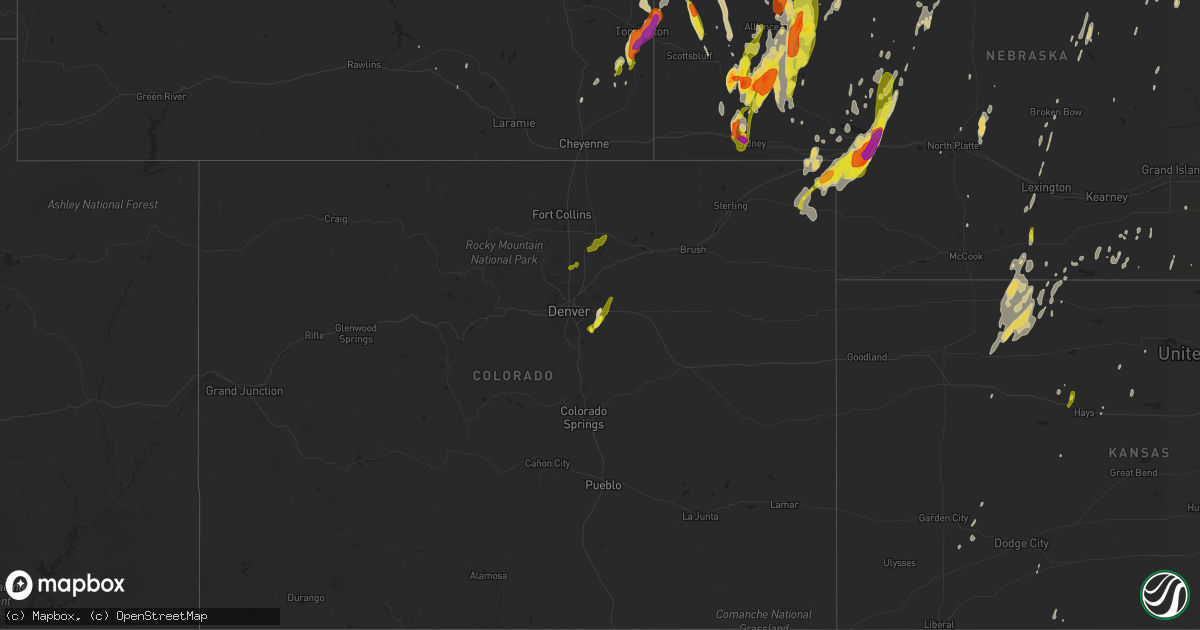
Hail Map on May 15, 2015
Get this storm
May 15 map
$229
one time, instant access
Download today. No call, no setup
Keep the $229
Bought the map and want the full workflow? Apply the entire $229 to a subscription within 7 days. None of it is wasted.
Every map, not just this one
This buys you this map. Subscription and you get every map we run, in the markets you choose from a few cities to whole states to nationwide. Plus real-time alerts the moment a storm fires.
Contact data
Name, contact info, occupancy, even credit band for addresses in the footprint. You go from where it hit to who to call.
Become the source they trust
Unlimited branding weather history reports on demand. You already have the documented answer ready for the property owner, and you are the one who showed up with it.
Property data and RoofTrace estimates
Pull up any address you have got, its value and the exact code rules for that jurisdiction, straight from One Click Code. Then RoofTrace estimates the squares, pitch, and roof value, priced the way you price.
States Impacted by Hail Map on May 15, 2015
Storm reports
Kansas
| Date | Description |
|---|---|
| 05/15/20156:24 PM CDT | Not very well defined tornado... But the spotter did confirm that he could see it on the ground. |
| 05/15/20156:22 PM CDT | Not very well defined tornado... But the spotter did confirm that he could see it on the ground. |
| 05/14/201510:21 PM CDT | A local report indicates 60 MPH wind near GOODLAND |
| 05/14/201510:20 PM CDT | Carport blown over a building and onto main street. |
| 05/14/20157:41 PM CDT | Brief tornado reported. Lasted a few minutes and has since lifted. |
| 05/14/20157:18 PM CDT | A local report indicates 1.00 inch wind near 9 NE ELLIS |
Wyoming
| Date | Description |
|---|---|
| 05/15/20154:55 PM CDT | Power lines down. Damage to roofs and outbuildings. |
| 05/15/20154:48 PM CDT | Covering the ground. |
| 05/15/20154:48 PM CDT | A local report indicates a tornado near 3 S TORRINGTON |
New Mexico
| Date | Description |
|---|---|
| 05/14/201510:47 PM CDT | A local report indicates 1.00 inch wind near 6 SE PEP |
| 05/14/201510:42 PM CDT | A local report indicates 2.00 inch wind near MCDONALD |
| 05/14/201510:32 PM CDT | A local report indicates 1.75 inch wind near LOVINGTON |
Texas
| Date | Description |
|---|---|
| 05/15/20154:55 PM CDT | Willacy county emergency manager reported a telephone pole knocked down at 100 east sunset street in raymondville. |
| 05/15/20151:28 PM CDT | A local report indicates 65 MPH wind near 1 S REFUGIO |
| 05/15/20151:25 PM CDT | Building blown down... Trees and powerlines down near yorktown and rodd field. Also street flooding. |
| 05/15/20151:22 PM CDT | *** 3 inj *** san patricio law enforcement and emergency management reported damage to tpco plant near highway 35/361 just east of gregory. The building was damaged the |
| 05/15/20151:20 PM CDT | *** 3 inj *** nws storm survey... Photos and video shared by media confirmed an ef-0 tornado with winds estimated 75-85 mph...touched down near the vostalpine plant near (crp |
| 05/15/20151:17 PM CDT | A local report indicates 60 MPH wind near PORTLAND |
| 05/15/20151:05 PM CDT | An nws damage survey team has confirmed a brief tornado touchdown occurred just south of yorktown blvd on corpus christis southside. The damage was primarily confined t |
| 05/15/20151:02 PM CDT | Media facebook page showed large tree limbs broken in front of kiii news station. |
| 05/15/20151:00 PM CDT | Large tree limbs down near kostoryz road and saratoga blvd. |
| 05/15/201512:28 PM CDT | Trained spotter at rest stop on i-37 near edroy estimated 60-65 mph wind gusts. |
| 05/15/201512:27 PM CDT | Barn roof blown onto highway 77. |
| 05/15/201511:18 AM CDT | Video from media facebook page confirmed brief tornado touch down in open field. |
| 05/14/201511:42 PM CDT | Part of the roof of a frame house removed. Trailer home pushed off pinnings abt 2 ft. Metal poles ripped outof ground. |
Nebraska
| Date | Description |
|---|---|
| 05/15/20156:45 PM CDT | Quarter to golfball size hail. |
| 05/15/20156:42 PM CDT | Marble to quarter size hail with very heavy rain. |
| 05/15/20156:32 PM CDT | A local report indicates 1.75 inch wind near 4 W BRIDGEPORT |
| 05/15/20156:25 PM CDT | Moved a picnic table 20 feet and destroyed it. |
| 05/15/20156:20 PM CDT | Hail ranged from golf ball to baseball size |
| 05/15/20156:15 PM CDT | A local report indicates 1.00 inch wind near 5 NNE LISCO |
| 05/15/20156:01 PM CDT | Quarter to hen egg size hail. |
| 05/15/20155:52 PM CDT | Dime to quarter size hail. |
| 05/15/20154:45 PM CDT | A local report indicates 1.25 inch wind near BRIDGEPORT |
| 05/15/20154:35 PM CDT | Significant damage to vehicles. |
| 05/15/20153:40 PM CDT | A local report indicates 1.25 inch wind near 10 N BROWNSON |
| 05/15/20153:38 PM CDT | A local report indicates 1.00 inch wind near 9 W GURLEY |
| 05/15/20153:30 PM CDT | Ping-pong to golf-ball sized hail reported. |
| 05/14/201510:16 PM CDT | A local report indicates 1.50 inch wind near ROSCOE |
| 05/14/201510:10 PM CDT | A local report indicates 1.00 inch wind near 6 E ARTHUR |
| 05/14/20159:50 PM CDT | 60 mph winds reported as well |
| 05/14/20159:41 PM CDT | A local report indicates 1.75 inch wind near 1 SSE OGALLALA |
| 05/14/20159:39 PM CDT | Estimated wind speeds of 60 to 70 mph |
| 05/14/20159:24 PM CDT | A local report indicates 1.75 inch wind near 8 N GRANT |
| 05/14/20159:18 PM CDT | A local report indicates 1.00 inch wind near 5 W GRANT |
| 05/14/20159:15 PM CDT | Estimated 50 to 60 mph winds |
| 05/14/20159:08 PM CDT | Rushville volunteer fire and rescue reported tornado touched down 1.5 miles south of rushville near 808 pm mdt. The tornado moved north before lifting at 0810 pm mdt. N |
| 05/14/20159:08 PM CDT | Rushville volunteer fire and rescue reported tornado touched down near 0808 pm mdt...and moved north and lifted at 0810 pm mdt. No damage reported. |
| 05/14/20159:00 PM CDT | Estimated time of 900pm cdt |
| 05/14/20159:00 PM CDT | Estimated time of 900pm cdt |
| 05/14/20158:57 PM CDT | Wind speeds estimated at 50 to 60 mph |
| 05/14/20158:55 PM CDT | A local report indicates 1.00 inch wind near 5 NW ELLSWORTH |
| 05/14/20158:48 PM CDT | 5 miles north of arapahoe quarter size hail fell from 848 to 854 pm. |
| 05/14/20158:34 PM CDT | Tornado confirmed by chasers at 734 mdt. |
| 05/14/20158:32 PM CDT | A local report indicates 1.00 inch wind near 5 E GORDON |
| 05/14/20158:30 PM CDT | A local report indicates 1.00 inch wind near 5 N VENANGO |
| 05/14/20157:28 PM CDT | Mostly pea to nickel size hail with largest golfball. |
| 05/14/20157:15 PM CDT | A local report indicates 1.75 inch wind near 7 E ANTIOCH |
Arkansas
| Date | Description |
|---|---|
| 05/14/20158:40 PM CDT | Power lines were blown down. |
| 05/14/20158:40 PM CDT | Power poles and power lines were blown down on highway 241 west of u.s. 49. |
Indiana
| Date | Description |
|---|---|
| 05/15/20156:46 PM CDT | A local report indicates 60 MPH wind near 5 E TERRE HAUTE |
| 05/15/20156:45 PM CDT | Small tree limbs down. Location is us 41 and oregon church road |
| 05/15/20156:20 PM CDT | 60 mph wind measured ay channel 2 location. |
| 05/14/20157:33 PM CDT | Power lines down at 226th street and state route 38 |
Mississippi
| Date | Description |
|---|---|
| 05/15/20154:25 PM CDT | Trees downed along old hwy 19 in se lauderdale co |
| 05/15/20153:50 PM CDT | Trees were downed at calhoun ave and 11th st...along gordon ave...and along judkins rd. |
| 05/15/20153:40 PM CDT | A few trees were down. One tree was down on a house which was on fire. |
Missouri
| Date | Description |
|---|---|
| 05/15/20156:30 PM CDT | Tree limb down onto powerline. |
| 05/15/20152:35 PM CDT | *** 2 inj *** 2 recreational vehicles tipped over due to high winds at lakeside 370 rv park and campground. Two minor injuries reported. No damage to surrounding struct |
| 05/15/20151:06 PM CDT | Several tree limbs were snapped and a tree was uprooted. Time is estimted. |
| 05/14/20157:30 PM CDT | Public photo of 1.25in hail shared on social media. |
Tennessee
| Date | Description |
|---|---|
| 05/15/20155:00 PM CDT | A few trees down on winding ridge road. Trees blocking road. |
| 05/14/201510:00 PM CDT | Trees down and power outages reported throughout the county. Radar indicated winds were in the 40kt range. |
Colorado
| Date | Description |
|---|---|
| 05/15/20153:30 PM CDT | A local report indicates 1.00 inch wind near 5 SSE GREELEY |
| 05/15/20153:03 PM CDT | A local report indicates a tornado near 4 WSW HOYT |
| 05/15/20152:52 PM CDT | A local report indicates 1.00 inch wind near 1 NW FREDERICK |
| 05/15/20152:20 PM CDT | A local report indicates 1.25 inch wind near NW DACONO |
| 05/15/20152:00 PM CDT | A local report indicates 1.00 inch wind near 4 WSW ARAPAHOE PARK |
| 05/15/20151:52 PM CDT | A local report indicates 1.25 inch wind near 4 WSW ARAPAHOE PARK |
| 05/15/20151:52 PM CDT | A local report indicates 1.25 inch wind near 5 NNE PARKER |
| 05/14/20158:27 PM CDT | A local report indicates 1.50 inch wind near SE JULESBURG |
| 05/14/20158:00 PM CDT | A local report indicates 1.25 inch wind near 6 ESE FAIRFIELD |
| 05/14/20157:59 PM CDT | A local report indicates 1.00 inch wind near JULESBURG |
Louisiana
| Date | Description |
|---|---|
| 05/15/201512:45 PM CDT | Tree limb snapped... Fell on garage |
Florida
| Date | Description |
|---|---|
| 05/15/20151:20 PM CDT | 2 trees and a power line down just north of bonifay |
Illinois
| Date | Description |
|---|---|
| 05/15/20155:55 PM CDT | Two trees down on roads in danville. Trees were small and old/dead. |
| 05/15/20155:53 PM CDT | Numerous trees down and power outages. Time estimated. |
| 05/15/20154:56 PM CDT | One power pole snapped. Time estimated. Relayed by media. |
| 05/15/20154:54 PM CDT | Tree limbs down on mlk drive. Time estimated. From wand-tv. |
| 05/15/20154:51 PM CDT | One tree blown down. Relayed by wcia-tv. |
| 05/15/20154:36 PM CDT | Tree limb fell on a power line. From gust front. |
| 05/15/20153:45 PM CDT | Multiple power poles down east of village. From pawnee esda. |
| 05/15/20153:00 PM CDT | Several trees down within the city |
| 05/15/20152:57 PM CDT | Tree down blocking route 16 |
| 05/15/20152:47 PM CDT | Tree down blocking route 100 west of pierre marquette sp |
Cities Impacted by Hail Map on May 15, 2015
- Merriman, NE
- Gordon, NE
- Mooreland, OK
- Fayette, MO
- Higbee, MO
- Boonville, MO
- Jal, NM
- Loose Creek, MO
- Linn, MO
- Chadron, NE
- Hammon, OK
- Grant, NE
- Ogallala, NE
- Keystone, NE
- Brule, NE
- Chester, OK
- Lovington, NM
- Pine Ridge, SD
- Mcdonald, NM
- Lentner, MO
- Shelbyville, MO
- Clarence, MO
- Elida, NM
- Pep, NM
- Portage Des Sioux, MO
- Oneill, NE
- Wildersville, TN
- Morton, TX
- Sudan, TX
- Muleshoe, TX
- Maple, TX
- Oshkosh, NE
- Lakeside, NE
- Ellsworth, NE
- Terre Haute, IN
- Hay Springs, NE
- Robinsonville, MS
- Tunica, MS
- Farwell, TX
- Santa Fe, MO
- Paris, MO
- Julesburg, CO
- Fargo, OK
- Versailles, MO
- Seagraves, TX
- Buffalo, OK
- House, NM
- Fort Sumner, NM
- Long Valley, SD
- Gruver, TX
- Minatare, NE
- Hemingford, NE
- Alliance, NE
- Harrison, NE
- Marsland, NE
- Valentine, NE
- Sidney, NE
- Doniphan, MO
- Marshall, MO
- Glasgow, MO
- Nelson, MO
- Franklin, MO
- Slater, MO
- Utica, SD
- Yankton, SD
- Bridgeport, NE
- Arnett, OK
- Gage, OK
- Lenora, KS
- Jerseyville, IL
- Grafton, IL
- Whitman, NE
- Hattieville, AR
- Amherst, CO
- Venango, NE
- Sutherland, NE
- Paxton, NE
- Arthur, NE
- Jefferson City, MO
- Taiban, NM
- Chappell, NE
- Stinnett, TX
- Lake Cormorant, MS
- Stuart, NE
- Montgomery, AL
- Bayard, NE
- Crenshaw, MS
- Saint Petersburg, FL
- Happy, TX
- Angora, NE
- Lisco, NE
- Broadwater, NE
- Spearman, TX
- Wathena, KS
- Reliance, SD
- Kennebec, SD
- Hamill, SD
- Arnold, NE
- Brady, NE
- Stapleton, NE
- Maxwell, NE
- Norcatur, KS
- Norton, KS
- Pilot Grove, MO
- Uriah, AL
- Colome, SD
- Aurora, CO
- Parker, CO
- Olaton, KY
- Beaver Dam, KY
- Hartford, KY
- Wynne, AR
- Cherry Valley, AR
- Oakwood, IL
- Fithian, IL
- Sharon, OK
- Mcalister, NM
- Tucumcari, NM
- Pinellas Park, FL
- Vermillion, SD
- Volin, SD
- Gayville, SD
- Wakonda, SD
- Taylor, NE
- Causey, NM
- Wagner, SD
- Spalding, NE
- Greeley, NE
- Russell, KS
- Table Rock, NE
- Smithville, MO
- Manville, WY
- Oaktown, IN
- Lynch, NE
- Verdigre, NE
- Ewing, NE
- Orchard, NE
- Page, NE
- Bertrand, MO
- Sikeston, MO
- Wilber, NE
- Clatonia, NE
- Crete, NE
- Hallam, NE
- Martell, NE
- Roca, NE
- Sprague, NE
- Claude, TX
- Holstein, NE
- Campbell, NE
- Minden, NE
- Mount Olive, IL
- Carlisle, IN
- Franklin, NE
- Marble Hill, MO
- Anabel, MO
- Marks, MS
- Irene, SD
- Sunrise Beach, MO
- Crofton, NE
- Fordyce, NE
- Saint Helena, NE
- Torrington, WY
- Robertsville, MO
- Vinson, OK
- Tatum, NM
- Patton, MO
- Shelbina, MO
- Rosedale, IN
- Rogers, NM
- Bristow, IN
- Birdseye, IN
- Morrill, NE
- Alma, NE
- Orleans, NE
- Wilmington, OH
- Burwell, NE
- Copeland, KS
- Turpin, OK
- Ashby, NE
- Hawk Springs, WY
- Borger, TX
- Olney, IL
- Hurley, SD
- Davis, SD
- Perryton, TX
- Lesterville, SD
- Sayre, OK
- Saint Francisville, LA
- Haxtun, CO
- Elwood, NE
- Pecos, TX
- Balmorhea, TX
- Blairstown, MO
- Cisne, IL
- Mount Erie, IL
- Roseland, NE
- Bladen, NE
- Arapahoe, NE
- Malta Bend, MO
- Lexington, NE
- Broken Bow, NE
- Lincoln, NE
- Rushville, NE
- Watkins, CO
- Andrews, TX
- Eunice, NM
- Bloomington, NE
- Hildreth, NE
- Columbia, IL
- Barlow, KY
- Cairo, IL
- Villa Ridge, IL
- Olmsted, IL
- Sledge, MS
- Powell, WY
- Ovid, CO
- Burke, SD
- La Plata, MO
- Stendal, IN
- Huntingburg, IN
- Rhineland, MO
- Hermann, MO
- Mutual, OK
- Mullen, NE
- Lorenzo, TX
- Barnett, MO
- Gravois Mills, MO
- Tennyson, IN
- Chugwater, WY
- Presho, SD
- Catlin, IL
- Bingham, NE
- Mangum, OK
- Big Springs, NE
- Lewellen, NE
- Potter, NE
- Selden, KS
- Clayton, KS
- Morland, KS
- Hill City, KS
- Wilsonville, NE
- Holbrook, NE
- Hendley, NE
- Jennings, KS
- Royal, NE
- Waterloo, IL
- Almena, KS
- Danville, IL
- Willow, OK
- Brighton, TN
- Covington, TN
- Saint Charles, MO
- Hillsboro, IN
- Norman, IN
- Marion, KY
- Coldwater, MS
- Niobrara, NE
- Fairview, SD
- Hudson, SD
- Ellsinore, MO
- Tabor, SD
- Tryon, NE
- Yoder, WY
- Friona, TX
- Sheridan, IN
- Whitestown, IN
- Hereford, TX
- Bovina, TX
- Dimmitt, TX
- Beaver City, NE
- Oconto, NE
- Veedersburg, IN
- Hernando, MS
- Gregory, SD
- Salina, KS
- Lebanon, IN
- Fairmount, IL
- Lonedell, MO
- Holden, MO
- Ideal, SD
- Witten, SD
- Chesterfield, MO
- Cleveland, AR
- Selmer, TN
- Ingalls, KS
- Benton, IL
- Winner, SD
- Dalton, NE
- Cortland, NE
- Hazen, AR
- Auburn, NE
- Westport, TN
- Holladay, TN
- Indianola, IL
- Eureka, MO
- Lake Andes, SD
- Republican City, NE
- Naponee, NE
- Wilcox, NE
- Ord, NE
- Brussels, IL
- Golden Eagle, IL
- Catawissa, MO
- Dittmer, MO
- Pacific, MO
- House Springs, MO
- Cedar Hill, MO
- Hobbs, NM
- Cody, WY
- Climax Springs, MO
- Stover, MO
- Mill Spring, MO
- Chambers, NE
- North Platte, NE
- De Soto, MO
- Festus, MO
- Pawnee City, NE
- Robinson, IL
- Victoria, KS
- Lingle, WY
- Veteran, WY
- Cave In Rock, IL
- Platte, SD
- Palestine, IL
- Dallas, SD
- Leedey, OK
- Cheyenne, OK
- Gurley, NE
- Winnetoon, NE
- Sullivan, IN
- Woodward, OK
- Ellis, KS
- Manhattan, KS
- Freedom, OK
- Viborg, SD
- Centerville, SD
- Hyannis, NE
- Inland, NE
- Atmore, AL
- Perdido, AL
- New Athens, IL
- Prairie View, KS
- Inman, NE
- Creighton, NE
- Natoma, KS
- Glenrock, WY
- Mission Hill, SD
- Des Arc, MO
- Annapolis, MO
- Carlisle, AR
- Lemoyne, NE
- Long Island, KS
- Chancellor, SD
- Carterville, IL
- Oxford, NE
- Bristow, NE
- Spencer, NE
- Humboldt, NE
- Cody, NE
- Stamford, NE
- Bowling Green, MO
- Rock River, WY
- Tyrone, OK
- Hooker, OK
- Beattie, KS
- Lagrange, WY
- Evansville, WY
- Batesland, SD
- Wynot, NE
- Clarendon, AR
- Ashland, KS
- Worden, IL
- Staunton, IL
- Excello, MO
- Jacksonville, MO
- Sutton, NE
- Henderson, NE
- Portales, NM
- Lamar, IN
- Evanston, IN
- Holyoke, CO
- Paoli, CO
- Hillsboro, MO
- Pevely, MO
- Arrow Rock, MO
- New Franklin, MO
- Gilliam, MO
- Ferdinand, IN
- Saint Meinrad, IN
- Lambert, MS
- Columbus, IN
- Nashville, IN
- Kilgore, NE
- Maywood, NE
- Laddonia, MO
- Richmond, MO
- Zachary, LA
- Guide Rock, NE
- Grandin, MO
- Kersey, CO
- Greeley, CO
- La Salle, CO
- Platteville, CO
- Bennett, CO
- Dacono, CO
- Frederick, CO
- Fort Lupton, CO
- Longmont, CO
- Firestone, CO
- Erie, CO
- Charleston, MO