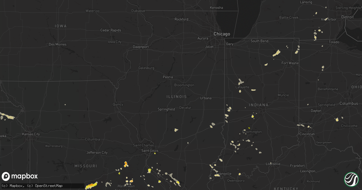
Hail Map in Illinois on May 14, 2022
Get this storm
May 14 map
$229
one time, instant access
Download today. No call, no setup
Keep the $229
Bought the map and want the full workflow? Apply the entire $229 to a subscription within 7 days. None of it is wasted.
Every map, not just this one
This buys you this map. Subscription and you get every map we run, in the markets you choose from a few cities to whole states to nationwide. Plus real-time alerts the moment a storm fires.
Contact data
Name, contact info, occupancy, even credit band for addresses in the footprint. You go from where it hit to who to call.
Become the source they trust
Unlimited branding weather history reports on demand. You already have the documented answer ready for the property owner, and you are the one who showed up with it.
Property data and RoofTrace estimates
Pull up any address you have got, its value and the exact code rules for that jurisdiction, straight from One Click Code. Then RoofTrace estimates the squares, pitch, and roof value, priced the way you price.
Storm reports in Illinois
Illinois
| Date | Description |
|---|---|
| 05/14/20226:05 AM CDT | At 1104 PM CDT, a severe thunderstorm was located over Carbondale, moving east at 20 mph. HAZARD...60 mph wind gusts and quarter size hail. SOURCE...Trained weather spotters. At 1100 PM, a 60 mph wind gust was reported in Carbondale. IMPACT...Hail damage to vehicles is expected. Expect wind damage to roofs, siding, and trees. This severe thunderstorm will be near... Cambria around 1115 PM CDT. Carterville around 1120 PM CDT.Other locations in the path of this severe thunderstorm includeCrainville and Energy. |
| 05/14/20224:12 AM CDT | At 912 PM CDT, a severe thunderstorm was located east of Shawneetown, moving south at 20 mph. HAZARD...60 mph wind gusts and quarter size hail. SOURCE...Radar indicated. IMPACT...Hail damage to vehicles is expected. Expect wind damage to roofs, siding, and trees. This severe thunderstorm will remain over mainly rural areas of southwestern Union County. |
| 05/14/20224:03 AM CDT | At 902 PM CDT, a severe thunderstorm was located near Bloomsdale, moving southeast at 10 mph. HAZARD...60 mph wind gusts and quarter size hail. SOURCE...Radar indicated. IMPACT...Hail damage to vehicles is expected. Expect wind damage to roofs, siding, and trees. Locations impacted include... Bloomsdale.This includes Interstate 55 in Missouri between exits 157 and 162. |
| 05/14/20222:15 AM CDT | At 715 PM CDT, a severe thunderstorm was located near Belleville, moving east at 5 mph. HAZARD...60 mph wind gusts and quarter size hail. SOURCE...Radar indicated. IMPACT...Hail damage to vehicles is expected. Expect wind damage to roofs, siding, and trees. This severe thunderstorm will be near... Fairview Heights around 720 PM CDT.Other locations in the path of this severe thunderstorm includeSwansea, Belleville, Shiloh, Freeburg, Scott AFB and Smithton.This includes Interstate 64 in Illinois between exits 9 and 19. |
| 05/13/202211:04 PM CDT | Trained spotter reporting 1 inch diameter hail over downtown carbondale. |
| 05/13/202211:00 PM CDT | Spotter also observed pea size hail. |
| 05/13/202210:59 PM CDT | Report from mping: half dollar |
| 05/13/20227:30 PM CDT | Hail and strong winds. Time estimated from radar. |
All States Impacted by Hail Map on May 14, 2022
Cities Impacted by Hail Map on May 14, 2022
- Hot Springs, SD
- Grand Blanc, MI
- Shenandoah, IA
- Roachdale, IN
- Perrinton, MI
- Ashley, MI
- Hubbardston, MI
- Adrian, MI
- Manitou Beach, MI
- Onsted, MI
- Brighton, MI
- Howell, MI
- Cuba, KS
- Belleville, KS
- Harlan, IA
- Baileyville, KS
- Axtell, KS
- Harrisville, NY
- Kendallville, IN
- Ionia, MI
- Muir, MI
- Michigantown, IN
- Frankfort, IN
- Odon, IN
- Montgomery, IN
- Plainville, IN
- Grass Lake, MI
- Stockbridge, MI
- Munith, MI
- Saint Charles, MI
- Chesaning, MI
- Plainfield, IN
- Uniontown, OH
- Mogadore, OH
- Akron, OH
- Bison, KS
- Rush Center, KS
- La Crosse, KS
- Stockton, KS
- Logan, KS
- Lenora, KS
- Bogue, KS
- Bladen, NE
- Minden, NE
- Heartwell, NE
- Holstein, NE
- Roseland, NE
- Glenvil, NE
- Kenesaw, NE
- Ayr, NE
- Blue Hill, NE
- Lawrence, NE
- Belleville, IL
- Onaway, MI
- Bicknell, IN
- Edwardsport, IN
- Jacob, IL
- Gorham, IL
- Wapakoneta, OH
- Salvisa, KY
- Harrodsburg, KY
- Corning, KS
- Willisburg, KY
- Mackville, KY
- Percy, IL
- Steeleville, IL
- Afton, OK
- Chelsea, OK
- Big Cabin, OK
- Pryor, OK
- Claremore, OK
- Jay, OK
- Ketchum, OK
- Strang, OK
- Vinita, OK
- Adair, OK
- Eucha, OK
- Grove, OK
- Waverly, KY
- Morganfield, KY
- Uniontown, KY
- Bedford, IN
- Mitchell, IN
- Park Hills, MO
- Farmington, MO
- Griffin, IN
- Poseyville, IN
- Roscommon, MI
- Wakeeney, KS
- Chester, IL
- Warsaw, IN
- Ligonier, IN
- Albion, IN
- Cromwell, IN
- Pierceton, IN
- Larwill, IN
- North Webster, IN
- Leesburg, IN
- Kimmell, IN
- Saint Joe, IN
- Butler, IN
- Auburn, IN
- Atlanta, MI
- Lewiston, MI
- Saint Peter, IL
- Westfield, IL
- Martinsville, IL
- Casey, IL
- Orient, IA
- Fontanelle, IA
- Tipton, MI
- Tecumseh, MI
- Riley, KS
- Unionville, MI
- Sebewaing, MI
- Bluffton, OH
- Mount Pleasant, MI
- Rosebush, MI
- Coleman, MI
- Ann Arbor, MI
- Geneseo, KS
- Little River, KS
- Westphalia, IN
- Carlisle, IN
- Sandborn, IN
- Gentryville, IN
- Bannister, MI
- Steelville, MO
- Cuba, MO
- Ithaca, MI
- Elnora, IN
- Utica, OH
- Olive Hill, KY
- Sandy Hook, KY
- Webbville, KY
- Blaine, KY
- Isonville, KY
- Terre Haute, IN
- West Terre Haute, IN
- Canton, OH
- North Canton, OH
- Murphysboro, IL
- Carbondale, IL
- Pinckneyville, IL
- Ava, IL
- Campbell Hill, IL
- Makanda, IL
- Montezuma, IN
- Hillsdale, IN
- Bloomingdale, IN
- Rockville, IN
- Waynesville, MO
- Richland, MO
- Laquey, MO
- Fort Leonard Wood, MO
- Falcon, MO
- Lebanon, MO
- Grovespring, MO
- Saginaw, MI
- Medina, OH
- Hinckley, OH
- Washington, IN
- Holly, MI
- Martinsville, IN
- Cincinnati, OH
- Mcpherson, KS
- Galva, KS
- Solsberry, IN
- Bloomfield, IN
- Fairgrove, MI
- Akron, MI
- Rhodes, MI
- Beaverton, MI
- Hope, MI
- Danville, OH
- Walhonding, OH
- Beattie, KS
- Morland, KS
- Hill City, KS
- Elm Creek, NE
- Kearney, NE
- Campbell, NE
- Guide Rock, NE
- Hildreth, NE
- Cozad, NE
- Wilcox, NE
- Funk, NE
- Smithfield, NE
- Bertrand, NE
- Gothenburg, NE
- Red Cloud, NE
- Willow Island, NE
- Axtell, NE
- Elwood, NE
- Riverton, NE
- Loomis, NE
- Overton, NE
- Lexington, NE
- Upland, NE
- Holdrege, NE
- Morehead, KY
- Larned, KS
- Prairie Du Rocher, IL
- Fults, IL
- Washington Court House, OH
- Clayton, MI
- Salem, MO
- Evansville, IL
- Ellis Grove, IL
- Centralia, KS
- Vermillion, KS
- Seneca, KS
- Goff, KS
- Perry, OK
- Wolcottville, IN
- South Milford, IN
- Drury, MO
- Killbuck, OH
- Grandview, IN
- Chatom, AL
- Tibbie, AL
- Wagarville, AL
- Carroll, IA
- Templeton, IA
- Dedham, IA
- Netawaka, KS
- Cummings, KS
- Everest, KS
- Atchison, KS
- Lancaster, KS
- Powhattan, KS
- Whiting, KS
- Sabetha, KS
- Wetmore, KS
- Effingham, KS
- Horton, KS
- Tye, TX
- Merkel, TX
- Cannelburg, IN
- Loogootee, IN
- Hesston, KS
- Moundridge, KS
- Cuttingsville, VT
- Seville, OH
- Lodi, OH
- Chippewa Lake, OH
- Almena, KS
- Norton, KS
- Prairie View, KS
- Phillipsburg, KS
- Glade, KS
- Montrose, MI
- Hamburg, IA
- Burton, OH
- Alpena, MI
- Lachine, MI
- Herron, MI
- Portsmouth, IA
- Woodbine, IA
- Panama, IA
- Edon, OH
- Hamilton, IN
- Caledonia, MO
- Belleview, MO
- Belgrade, MO
- Potosi, MO
- Kingston, MI
- Caro, MI
- Osceola, IA
- Grayville, IL
- Crossville, IL
- Bern, KS
- Campbellsburg, IN
- Salem, IN
- Pratt, KS
- Grayling, MI
- Johannesburg, MI
- Silver Lake, IN
- Akron, IN
- Pandora, OH
- Ottawa, OH
- Brookston, IN
- West Lafayette, IN
- Battle Ground, IN
- Manning, IA
- Audubon, IA
- Harrison, MI
- Cass City, MI
- Farragut, IA
- Riverton, IA
- Sidney, IA
- Arcanum, OH
- Lewisburg, OH
- Smith Center, KS
- Athol, KS
- Clarinda, IA
- Essex, IA
- Morenci, MI
- Fayette, OH
- Hudson, MI
- Beatrice, NE
- De Witt, NE
- Soldier, KS
- Haddam, KS
- Montezuma, KS
- Ingalls, KS
- Cimarron, KS
- Ensign, KS
- Fowler, KS
- Meade, KS
- Plains, KS
- Colton, NY
- Scandia, KS
- Hamilton, OH
- Fairfield, OH
- Okeana, OH
- Edgerton, OH
- West Harrison, IN
- Cedar Grove, IN
- Bay City, MI
- Nebraska City, NE
- Talmage, NE
- Dunbar, NE
- Lorton, NE
- Red Oak, IA
- Eustis, NE
- Farnam, NE
- Wheeling, MO
- Linneus, MO
- Lueders, TX
- Romney, IN
- Lafayette, IN
- McIntosh, AL
- Hornbeak, TN
- Union City, TN
- Loxley, AL
- Alexander, KS
- Burdett, KS
- Rozel, KS
- Ness City, KS
- Nekoma, KS
- Collyer, KS
- Utica, KS
- Ransom, KS
- Bazine, KS
- Brownell, KS
- Garfield, KS
- Sterling, NE
- Burr, NE
- Syracuse, NE
- Cook, NE
- Broken Arrow, OK
- Worthington, IN
- Berryville, AR
- Green Forest, AR
- Pawhuska, OK
- Bartlesville, OK
- Garfield, AR
- Rogers, AR
- Sand Springs, OK
- Noble, MO
- Thornfield, MO
- Wasola, MO
- Brixey, MO
- Squires, MO
- Gainesville, MO
- Mulhall, OK
- Marshall, OK
- Sapulpa, OK
- Harrison, AR
- Butler, AL
- Salina, KS
- Hartville, MO
- New Albany, IN
- Louisville, KY
- Coyle, OK
- Guthrie, OK
- Perkins, OK
- Fort Lauderdale, FL
- Fordland, MO
- Seymour, MO
- Hays, KS
- Olmsted, IL
- Utica, KY
- Philpot, KY
- Friendship, TN
- Finley, TN
- Alma, KS
- Belpre, KS
- Buffalo, OK
- Boca Raton, FL
- Delray Beach, FL
- Wingate, TX
- Fredericktown, MO
- Manhattan, KS
- Taneyville, MO
- Forsyth, MO
- Charleston, MO
- Hardtner, KS
- Hanson, KY
- Manitou, KY
- Saint Clair, MO
- Sullivan, MO
- Bourbon, MO
- Marble Falls, AR
- Citronelle, AL
- Deer Park, AL
- Powersite, MO
- Kirbyville, MO
- Bixby, MO
- Patoka, IN
- Princeton, IN
- Barlow, KY
- Wickliffe, KY
- Sturgis, KY
- Lewis, KS
- Fifty Six, AR
- Mountain View, AR
- Timbo, AR
- Smithland, KY
- Kinsley, KS
- Pawnee City, NE
- Delta, OH
- Rockwood, IL
- Tulsa, OK
- Matthews, MO
- Kevil, KY
- Bardwell, KY
- Branson, MO
- Hollister, MO
- Kingston, AR
- Monrovia, IN
- Clayton, IN
- Mooresville, IN
- Hartford, KY
- Whitesville, KY
- Haviland, KS
- Marlette, MI
- Decker, MI
- Cayuga, IN
- Duke, MO
- Newburg, MO
- Edgar Springs, MO
- Collinsville, OK
- Sperry, OK
- Colcord, OK
- Poplarville, MS
- Leasburg, MO
- Springville, IN
- Benton, MO
- Haysville, KS
- Alva, OK
- Clinton, AR
- Wamego, KS
- Saint George, KS
- Greensburg, KS
- Offerle, KS
- Hanston, KS
- Coats, KS
- Randolph, KS
- Leonardville, KS
- New Harmony, IN
- Mount Vernon, IN
- Wadesville, IN
- Percival, IA
- McCaskill, AR
- New Holland, OH
- Medicine Lodge, KS
- Sharon, KS
- Bonne Terre, MO
- Beulah, MO
- Rolla, MO
- Murray, KY
- Dexter, KY
- Burlington, OK
- Kiowa, KS
- Evansville, IN
- Stroud, OK
- Gravette, AR
- Covington, OK
- Lucien, OK
- Hampton, KY
- Bloomsdale, MO
- Lometa, TX
- Bend, TX
- San Saba, TX
- Sedan, KS
- Ava, MO
- Stillwater, OK
- Ramona, OK
- Bertrand, MO
- Eskridge, KS
- Ahoskie, NC
- Pass Christian, MS
- Gulfport, MS
- Perryville, MO
- Jasper, AR
- Witter, AR
- Kissee Mills, MO
- Lisman, AL
- Bronte, TX
- Gideon, MO
- Mansfield, MO
- Ponca City, OK
- May, OK
- Laverne, OK
- Rosston, OK
- Cedarcreek, MO
- Spencer, IN
- Prospect, KY
- Slaughters, KY
- Sebree, KY
- Providence, KY
- Dixon, KY
- Henderson, KY
- Robards, KY
- Corydon, KY
- Nebo, KY
- Madisonville, KY
- West Chester, OH
- Ellis, KS
- Pomona, IL
- Frankfort, KY
- Bagdad, KY
- Nowata, OK
- Delaware, OK
- Ochelata, OK
- Talala, OK
- East Prairie, MO
- Edmonton, KY
- Knob Lick, KY
- Glasgow, KY
- Oologah, OK
- Ponca, AR
- Sun City, KS
- Belle Plaine, KS
- Macomb, MO
- Norwood, MO
- Universal, IN
- Clinton, IN
- Silverhill, AL
- Robertsdale, AL
- Owensburg, IN
- Burlison, TN
- Atoka, TN
- Drummonds, TN
- Millington, TN
- Brighton, TN
- Munford, TN
- Coffeeville, AL
- Bogue Chitto, MS
- Murfreesboro, TN
- Macksville, KS
- Oldfield, MO
- Sparta, MO
- Bruner, MO
- Senath, MO
- Hornersville, MO
- Mountain Grove, MO
- Sikeston, MO
- Emmet, AR
- Prescott, AR
- Minneola, KS
- Englewood, KS
- Ashland, KS
- Marland, OK
- Fairfax, OK
- Ralston, OK
- Carriere, MS
- Picayune, MS
- Saint Martinville, LA
- Breaux Bridge, LA
- Minneapolis, KS
- Beverly, KS
- Tescott, KS
- Sylvan Grove, KS
- Lincoln, KS
- Red Bud, IL
- Spavinaw, OK
- Ridgely, TN
- Sandy Hook, MS
- Grand Rivers, KY
- Lincoln, AR
- Fayetteville, AR
- Frankville, AL
- Lake Village, AR
- Leslie, AR
- Gilbertown, AL
- Toxey, AL
- Patton, MO
- Parkers Lake, KY
- Waynoka, OK
- Dyersburg, TN
- Derby, KS
- Saint James, MO
- Ledbetter, KY
- Brookport, IL
- Hickman, KY
- Bingham, IL
- Fillmore, IL
- Witt, IL
- Nokomis, IL
- Irving, IL
- Tiline, KY
- Burna, KY
- Calvert City, KY
- Benton, KY
- Bixby, OK
- Glenpool, OK
- Mounds, OK
- Jenks, OK
- Kiefer, OK
- Oran, MO
- Houghton Lake, MI
- Prudenville, MI
- Chandler, OK
- Jupiter, FL
- Palm Beach Gardens, FL
- Cabool, MO
- Hope, AR
- Saint Stephens, AL
- La Center, KY
- Villa Ridge, IL
- West Palm Beach, FL
- Loxahatchee, FL
- Bradleyville, MO
- Tryon, OK
- Agra, OK
- Anna, IL
- Dongola, IL
- Chunchula, AL
- Cambridge, KS
- Dexter, KS
- Cedar Vale, KS
- Crescent, OK
- Orlando, OK
- Peck, KS
- Clearwater, KS
- Owensville, IN
- Muscotah, KS
- Holton, KS
- Modoc, IL
- Mulvane, KS
- Parma, MO
- Pond Creek, OK
- Hunter, OK
- Caruthersville, MO
- Huntsville, AR
- Catoosa, OK
- Jachin, AL
- Crane, IN
- Shirley, AR
- Obion, TN
- Mena, AR
- Lead Hill, AR
- Blue Eye, MO
- Lebanon, TN
- Compton, AR
- Owasso, OK
- Orleans, IN
- Abilene, TX
- Wilmer, AL
- Paxico, KS
- McFarland, KS
- Viburnum, MO
- Farmington, AR
- Fort Supply, OK
- South West City, MO
- Boykins, VA
- Fairview, OK
- Ullin, IL
- Mound City, IL
- Grand Chain, IL
- Mounds, IL
- Pulaski, IL
- Clay, KY
- Mcminnville, TN
- Calhoun, KY
- Fenwick, MI
- Deweese, NE
- Ossineke, MI
- Nelson, NE
- Hubbard Lake, MI
- Oak, NE
- Ellettsville, IN
- Siloam Springs, AR
- Fox, AR
- Burbank, OK
- Chadwick, MO
- Rogersville, MO
- Garrison, MO
- Vanzant, MO
- Woodston, KS
- Sawyer, KS
- Wichita, KS


