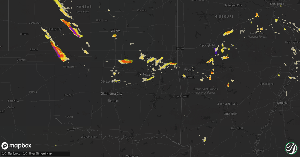
Hail Map on May 14, 2022
Get this storm
May 14 map
$229
one time, instant access
Download today. No call, no setup
Keep the $229
Bought the map and want the full workflow? Apply the entire $229 to a subscription within 7 days. None of it is wasted.
Every map, not just this one
This buys you this map. Subscription and you get every map we run, in the markets you choose from a few cities to whole states to nationwide. Plus real-time alerts the moment a storm fires.
Contact data
Name, contact info, occupancy, even credit band for addresses in the footprint. You go from where it hit to who to call.
Become the source they trust
Unlimited branding weather history reports on demand. You already have the documented answer ready for the property owner, and you are the one who showed up with it.
Property data and RoofTrace estimates
Pull up any address you have got, its value and the exact code rules for that jurisdiction, straight from One Click Code. Then RoofTrace estimates the squares, pitch, and roof value, priced the way you price.
States Impacted by Hail Map on May 14, 2022
Storm reports
Alabama
| Date | Description |
|---|---|
| 05/14/20225:16 PM CDT | Quarter to half dollar sized hail. Time estimated by radar. |
| 05/14/20223:59 AM CDT | At 859 PM CDT, a severe thunderstorm was located 8 miles west of McIntosh, or 10 miles northeast of Citronelle, moving south at 15 mph. HAZARD...60 mph wind gusts and quarter size hail. SOURCE...Radar indicated. IMPACT...Hail damage to vehicles is expected. Expect wind damage to roofs, siding, and trees. Locations impacted include... Citronelle, Gulfcrest, Mount Vernon and Movico. |
| 05/14/20223:21 AM CDT | At 821 PM CDT, a severe thunderstorm was located 6 miles east of Tibbie, or 8 miles southeast of Chatom, moving south at 15 mph. HAZARD...60 mph wind gusts and quarter size hail. SOURCE...Radar indicated. IMPACT...Hail damage to vehicles is expected. Expect wind damage to roofs, siding, and trees. Locations impacted include... Wagarville, Deer Park, Tibbie and McIntosh. |
| 05/14/20222:39 AM CDT | At 739 PM CDT, a severe thunderstorm was located 6 miles north of Saint Stephens, or 13 miles northwest of Jackson, moving southeast at 5 mph. HAZARD...60 mph wind gusts and quarter size hail. SOURCE...Radar indicated. IMPACT...Hail damage to vehicles is expected. Expect wind damage to roofs, siding, and trees. Locations impacted include... Jackson, Saint Stephens and Leroy. |
| 05/14/20221:02 AM CDT | At 602 PM CDT, a severe thunderstorm was located 4 miles west of Fulton, or 5 miles north of Grove Hill, and is nearly stationary. HAZARD...60 mph wind gusts and quarter size hail. SOURCE...Radar indicated. IMPACT...Hail damage to vehicles is expected. Expect wind damage to roofs, siding, and trees. Locations impacted include... Grove Hill and Fulton. |
| 05/14/202212:54 AM CDT | At 554 PM CDT, a severe thunderstorm was located 4 miles north of Loxley, and is nearly stationary. HAZARD...60 mph wind gusts and quarter size hail. SOURCE...Radar indicated. IMPACT...Hail damage to vehicles is expected. Expect wind damage to roofs, siding, and trees. Locations impacted include... Loxley and Silverhill. |
| 05/14/202212:11 AM CDT | At 511 PM CDT, a severe thunderstorm was located over Silverhill, or over Robertsdale, moving south at 10 mph. HAZARD...60 mph wind gusts and quarter size hail. SOURCE...Radar indicated. IMPACT...Hail damage to vehicles is expected. Expect wind damage to roofs, siding, and trees. Locations impacted include... Foley, Robertsdale, Loxley, Magnolia Springs, Summerdale, Silverhill and Elberta. |
Kentucky
| Date | Description |
|---|---|
| 05/14/20222:41 PM CDT | Tree on a house at 28th and kentucky streets. |
| 05/14/20222:37 PM CDT | Tree on car at southwestern parkway and herman street. Car was occupied but occupant was not injured. |
| 05/14/20224:15 AM CDT | At 914 PM CDT, a severe thunderstorm was located 7 miles southeast of Dixon, or 8 miles east of Providence, moving southeast at 20 mph. HAZARD...Ping pong ball size hail and 60 mph wind gusts. SOURCE...Radar indicated. IMPACT...People and animals outdoors will be injured. Expect hail damage to roofs, siding, windows, and vehicles. Expect wind damage to roofs, siding, and trees. Locations impacted include... Madisonville.This includes Interstate 69 in Kentucky between Mile Markers 115 and124. |
| 05/14/20223:18 AM CDT | At 817 PM CDT, a severe thunderstorm was located 7 miles west of Edmonton, moving east at 15 mph. HAZARD...60 mph wind gusts and quarter size hail. SOURCE...Radar indicated. IMPACT...Hail damage to vehicles is expected. Expect wind damage to roofs, siding, and trees. Locations impacted include... Edmonton. |
| 05/14/20221:02 AM CDT | At 601 PM CDT, a severe thunderstorm was located over Masonville, or 7 miles southeast of Owensboro, moving southeast at 10 mph. HAZARD...60 mph wind gusts and half dollar size hail. SOURCE...Radar indicated. IMPACT...Hail damage to vehicles is expected. Expect wind damage to roofs, siding, and trees. Locations impacted include... Whitesville.This includes Interstate 165 between Mile Markers 60 and 67. |
| 05/14/202212:21 AM CDT | At 520 PM CDT, a severe thunderstorm was located over Grandview, moving east at 10 mph. HAZARD...60 mph wind gusts and quarter size hail. SOURCE...Radar indicated. IMPACT...Hail damage to vehicles is expected. Expect wind damage to roofs, siding, and trees. This severe thunderstorm will remain over mainly rural areas of northwestern Hancock County, including the following locations... Lewisport and Waitman. |
| 05/14/202212:14 AM CDT | At 514 PM CDT, a severe thunderstorm was located over Grandview, or near Rockport, moving southeast at 5 mph. HAZARD...Ping pong ball size hail and 60 mph wind gusts. SOURCE...Radar indicated. IMPACT...People and animals outdoors will be injured. Expect hail damage to roofs, siding, windows, and vehicles. Expect wind damage to roofs, siding, and trees. This severe thunderstorm will remain over mainly rural areas of central Spencer and northeastern Daviess Counties, including the following locations... Chrisney. |
| 05/13/202211:53 PM CDT | Large tree limb in the roadway on north montgomery road. Tree limb... Apparently 3 to 4 inches in diameter... At the top. Other small limbs down in the area. |
| 05/13/202211:34 PM CDT | At 434 PM EDT, a severe thunderstorm was located 7 miles southwest of Williamstown, and is nearly stationary. HAZARD...60 mph wind gusts and quarter size hail. SOURCE...Radar indicated. IMPACT...Minor hail damage to vehicles is possible. Expect wind damage to trees and power lines. Locations impacted include... Williamstown, Corinth, Keefer, Elk Lake, Needmore, New Columbus, Cherry Grove, Holbrook, Lawrenceville and Natlee.This includes I-75 in Kentucky between mile markers 144 and 152. |
| 05/13/202210:10 PM CDT | At 310 PM EDT, a severe thunderstorm was located over Bruin, or near Grayson Lake State Park, moving southeast at 15 mph. HAZARD...60 mph wind gusts and quarter size hail. SOURCE...Radar indicated. IMPACT...Hail damage to vehicles is expected. Expect wind damage to roofs, siding, and trees. Locations impacted include... Culver. |
| 05/13/202210:00 PM CDT | At 300 PM EDT, a severe thunderstorm was located over Moon, or 8 miles south of Sandy Hook, moving east at 15 mph. HAZARD...60 mph wind gusts and quarter size hail. SOURCE...Radar indicated. IMPACT...Hail damage to vehicles is expected. Expect wind damage to roofs, siding, and trees. This severe thunderstorm will be near... Moon around 305 PM EDT. Mima around 310 PM EDT. Relief around 320 PM EDT.Other locations in the path of this severe thunderstorm includeGillem Branch and Keaton. |
Oklahoma
| Date | Description |
|---|---|
| 05/14/20227:54 AM CDT | At 1254 AM CDT, a severe thunderstorm was located 5 miles west of Okeene, moving southwest at 20 mph. HAZARD...Golf ball size hail and 60 mph wind gusts. SOURCE...Radar indicated. IMPACT...People and animals outdoors will be injured. Expect hail damage to roofs, siding, windows, and vehicles. Expect wind damage to roofs, siding, and trees. Locations impacted include... Watonga, Okeene, Canton, Longdale, Hitchcock, Eagle City, southeastern Canton Lake, Homestead and Southard. |
| 05/14/20227:29 AM CDT | At 1228 AM CDT, a severe thunderstorm was located 4 miles southwest of Okarche, moving northeast at 15 mph. HAZARD...60 mph wind gusts and quarter size hail. SOURCE...Radar indicated. IMPACT...Hail damage to vehicles is expected. Expect wind damage to roofs, siding, and trees. Locations impacted include... Kingfisher, Piedmont, Okarche and Concho. |
| 05/14/20227:12 AM CDT | At 1211 AM CDT, severe thunderstorms were located along a line extending from 5 miles southeast of Ames to 3 miles southwest of Fairview, moving south at 20 mph. HAZARD...70 mph wind gusts and ping pong ball size hail. SOURCE...Radar indicated. IMPACT...People and animals outdoors will be injured. Expect hail damage to roofs, siding, windows, and vehicles. Expect considerable tree damage. Wind damage is also likely to mobile homes, roofs, and outbuildings. Locations impacted include... Fairview, Okeene, Canton, Longdale, Ames, Loyal, Isabella, southeastern Canton Lake, Homestead, Southard and Lacey. |
| 05/14/20226:26 AM CDT | At 1126 PM CDT, severe thunderstorms were located along a line extending from 4 miles northeast of Billings to 4 miles west of Perry to near Mulhall to 4 miles northeast of Guthrie, moving east at 30 mph. HAZARD...60 mph wind gusts and quarter size hail. SOURCE...Radar indicated. IMPACT...Hail damage to vehicles is expected. Expect wind damage to roofs, siding, and trees. Locations impacted include... Stillwater, Guthrie, Perry, Chandler, Perkins, Langston, Morrison, Carney, Glencoe, Billings, Tryon, Ripley, Agra, Coyle, Red Rock, Mulhall, Marland, Orlando, Meridian and Fallis. |
| 05/14/20225:55 AM CDT | At 1055 PM CDT, a severe thunderstorm was located near Hunter, moving east at 15 mph. HAZARD...60 mph wind gusts and quarter size hail. SOURCE...Radar indicated. IMPACT...Hail damage to vehicles is expected. Expect wind damage to roofs, siding, and trees. Locations impacted include... Pond Creek, Billings and Hunter. |
| 05/14/20225:08 AM CDT | At 1008 PM CDT, a severe thunderstorm was located 8 miles south of Buffalo, moving southeast at 15 mph. HAZARD...Quarter size hail. SOURCE...Radar indicated. IMPACT...Damage to vehicles is expected. This severe thunderstorm will remain over mainly rural areas of southeastern Harper County. |
| 05/14/20224:33 AM CDT | At 933 PM CDT, a severe thunderstorm was located 7 miles west of Buffalo, moving southeast at 10 mph. HAZARD...Quarter size hail. SOURCE...Trained weather spotters reported quarter size hail west of Buffalo. IMPACT...Damage to vehicles is expected. Locations impacted include... Buffalo. |
| 05/14/20223:43 AM CDT | At 843 PM CDT, a severe thunderstorm was located near Capron, moving southeast at 10 mph. HAZARD...Ping pong ball size hail and 60 mph wind gusts. SOURCE...Radar indicated. IMPACT...People and animals outdoors will be injured. Expect hail damage to roofs, siding, windows, and vehicles. Expect wind damage to roofs, siding, and trees. Locations impacted include... Burlington, Driftwood, Ingersoll and Capron. |
| 05/14/20223:31 AM CDT | At 831 PM CDT, a severe thunderstorm was located 5 miles south of Buffalo, moving southeast at 20 mph. HAZARD...Golf ball size hail and 60 mph wind gusts. Accumulating small hail is also possible. SOURCE...Radar indicated. IMPACT...People and animals outdoors will be injured. Expect hail damage to roofs, siding, windows, and vehicles. Expect wind damage to roofs, siding, and trees. Locations impacted include... Fort Supply and Selman. |
| 05/14/20222:48 AM CDT | At 748 PM CDT, a severe thunderstorm was located 8 miles west of Buffalo, moving southeast at 25 mph. HAZARD...Two inch hail and 70 mph wind gusts. SOURCE...Radar indicated. IMPACT...People and animals outdoors will be injured. Expect hail damage to roofs, siding, windows, and vehicles. Expect considerable tree damage. Wind damage is also likely to mobile homes, roofs, and outbuildings. Locations impacted include... Buffalo and May. |
| 05/14/20222:40 AM CDT | Pic via twitter. |
| 05/14/20222:19 AM CDT | Report from mping: quarter |
| 05/14/20222:13 AM CDT | At 712 PM CDT, a severe thunderstorm was located 5 miles south of Englewood, moving northeast at 10 mph. HAZARD...60 mph wind gusts and quarter size hail. SOURCE...Radar indicated. IMPACT...Minor damage to roofs, siding, and trees is possible. Hail damage to vehicles is expected. Locations impacted include... Gate. |
| 05/14/20221:54 AM CDT | At 654 PM CDT, a severe thunderstorm was located near Acres, moving southeast at 25 mph. HAZARD...Golf ball size hail and 60 mph wind gusts. SOURCE...Radar indicated. IMPACT...People and animals outdoors will be injured. Expect hail damage to roofs, siding, windows, and vehicles. Expect wind damage to roofs, siding, and trees. Locations impacted include... Buffalo and Rosston. |
| 05/14/20221:50 AM CDT | Report from mping: quarter |
| 05/14/20221:48 AM CDT | Report from mping: quarter |
| 05/13/202211:30 PM CDT | A local report indicates 60 MPH wind near 6 SW MULHALL |
| 05/13/202210:07 PM CDT | At 307 AM CDT, a severe thunderstorm was located 6 miles east of Billings, moving east at 15 mph. HAZARD...Ping pong ball size hail and 60 mph wind gusts. SOURCE...Radar indicated. IMPACT...People and animals outdoors will be injured. Expect hail damage to roofs, siding, windows, and vehicles. Expect wind damage to roofs, siding, and trees. Locations impacted include... Ponca City, Red Rock, Marland, Sooner Lake, southwestern Kaw Lake and Ceres. |
| 05/13/20229:31 PM CDT | A local report indicates 1.00 inch wind near 5 E ROSSTON |
| 05/13/20228:51 PM CDT | A local report indicates 1.75 inch wind near 7 NNW FORT SUPPLY |
| 05/13/20228:50 PM CDT | A local report indicates 1.25 inch wind near 7 NNW FORT SUPPLY |
| 05/13/20228:39 PM CDT | At 139 AM CDT, severe thunderstorms were located along a line extending from 5 miles southeast of Hitchcock to 3 miles southeast of Oakwood, moving south at 15 mph. HAZARD...Ping pong ball size hail and 60 mph wind gusts. SOURCE...Radar indicated. IMPACT...People and animals outdoors will be injured. Expect hail damage to roofs, siding, windows, and vehicles. Expect wind damage to roofs, siding, and trees. Locations impacted include... Watonga, Thomas, Hitchcock, Greenfield, Oakwood, Eagle City and Fay. |
| 05/13/20228:22 PM CDT | Nickel to quarter size hail lasted 10 minutes with hail covering the ground. |
| 05/13/20228:11 PM CDT | At 111 AM CDT, a severe thunderstorm was located 4 miles west of Canton, moving southwest at 20 mph. HAZARD...Golf ball size hail and 60 mph wind gusts. SOURCE...Radar indicated. IMPACT...People and animals outdoors will be injured. Expect hail damage to roofs, siding, windows, and vehicles. Expect wind damage to roofs, siding, and trees. Locations impacted include... Canton, Oakwood, Eagle City and southeastern Canton Lake. |
| 05/13/20227:52 PM CDT | A local report indicates 2.50 inch wind near 3 W BUFFALO |
| 05/13/20227:49 PM CDT | A local report indicates 60 MPH wind near 3 SW BUFFALO |
| 05/13/20227:49 PM CDT | A local report indicates 2.25 inch wind near 3 W BUFFALO |
| 05/13/20227:45 PM CDT | A local report indicates 1.50 inch wind near 7 W BUFFALO |
| 05/13/20227:05 PM CDT | A local report indicates 2.00 inch wind near 13 NNW ROSSTON |
Virginia
| Date | Description |
|---|---|
| 05/13/202211:24 PM CDT | At 424 PM EDT, a severe thunderstorm was located near Boykins, moving east at 20 mph. HAZARD...60 mph wind gusts and quarter size hail. SOURCE...Radar indicated. IMPACT...Minor damage to vehicles is possible. Expect wind damage to trees and powerlines. This severe thunderstorm will be near... Newsoms around 445 PM EDT. Courtland around 455 PM EDT. Sedley around 510 PM EDT. Franklin and Hunterdale around 515 PM EDT.Other locations impacted by this severe thunderstorm includeVicksville, Handsom, Berlin, Manry, Worrell, Dory, Sunbeam,Riverdale, Sebrell and Branchville. |
| 05/13/202210:25 PM CDT | At 325 PM EDT, a severe thunderstorm was located near Stony Creek, or 10 miles northeast of Purdy, moving east at 15 mph. HAZARD...60 mph wind gusts and nickel size hail. SOURCE...Radar indicated. IMPACT...Expect damage to trees and powerlines. This severe thunderstorm will be near... Stony Creek around 335 PM EDT. Sussex around 400 PM EDT. Homeville around 415 PM EDT.Other locations impacted by this severe thunderstorm include Owens,Newville, Booker, Yale, Lumberton, Huske, Littleton and Hilda. |
West Virginia
| Date | Description |
|---|---|
| 05/13/202210:19 PM CDT | At 319 PM EDT, a severe thunderstorm was located over Blaine, moving southeast at 20 mph. HAZARD...60 mph wind gusts and quarter size hail. SOURCE...Radar indicated. IMPACT...Hail damage to vehicles is expected. Expect wind damage to roofs, siding, and trees. Locations impacted include... Louisa, Blaine, Ulysses, Martha, Charley, Houckville and Gallup. |
Michigan
| Date | Description |
|---|---|
| 05/14/20221:50 PM CDT | Tree down at intersection of kopke rd and rogers hwy. Time estimated by radar. |
| 05/14/20221:50 AM CDT | At 649 PM EDT, a severe thunderstorm was located 7 miles south of Carson City, or 10 miles northeast of Ionia, moving southeast at 15 mph. HAZARD...Quarter size hail. SOURCE...Radar indicated. IMPACT...Damage to vehicles is expected. Locations impacted include... St. Johns... Fowler... Westphalia... Lyons... Maple Rapids... Muir... Pewamo... Hubbardston... |
| 05/13/202210:56 PM CDT | At 356 PM EDT, a severe thunderstorm was located near Unionville, or near Akron, moving northeast at 15 mph. HAZARD...60 mph wind gusts and quarter size hail. SOURCE...Radar indicated. IMPACT...Hail damage to vehicles is expected. Expect wind damage to roofs, siding, and trees. This severe thunderstorm will be near... Gagetown around 430 PM EDT. Cass City and Owendale around 435 PM EDT.Other locations impacted by this severe thunderstorm include Colwood,Colling and Bach. |
| 05/13/202210:34 PM CDT | At 334 PM EDT, a severe thunderstorm was located 8 miles east of Spratt, or 8 miles southwest of Alpena, moving east at 15 mph. HAZARD...Quarter size hail. SOURCE...Radar indicated. IMPACT...Damage to vehicles is expected. Locations impacted include... Alpena. |
| 05/13/20229:36 PM CDT | At 236 PM EDT, a severe thunderstorm was located near Adrian, moving east at 15 mph. HAZARD...Quarter size hail. SOURCE...Radar indicated. IMPACT...Damage to vehicles is expected. This severe thunderstorm will be near... Adrian around 245 PM EDT. Tecumseh around 300 PM EDT. Britton around 325 PM EDT. Deerfield around 330 PM EDT.Other locations impacted by this severe thunderstorm includeRidgeway, Palmyra, Tipton and Holloway. |
| 05/13/20229:31 PM CDT | At 231 PM EDT, a severe thunderstorm was located near Morenci, moving southeast at 15 mph. HAZARD...Quarter size hail. SOURCE...Radar indicated. IMPACT...Damage to vehicles is expected. This severe thunderstorm will be near... Morenci around 235 PM EDT.Other locations impacted by this severe thunderstorm include Seneca,Jasper, Medina, Weston, Ogden Center, Canandaigua, Fairfield and SandCreek. |
| 05/13/20229:30 PM CDT | At 230 PM EDT, a severe thunderstorm was located over Lewiston, moving northeast at 10 mph. HAZARD...Quarter size hail. SOURCE...Radar indicated. IMPACT...Damage to vehicles is expected. This severe thunderstorm will remain over mainly rural areas of southeastern Otsego and southwestern Montmorency Counties. |
| 05/13/20229:21 PM CDT | At 221 PM EDT, a severe thunderstorm was located over Gregory, or 9 miles west of Pinckney, moving east at 15 mph. HAZARD...Quarter size hail. SOURCE...Radar indicated. IMPACT...Damage to vehicles is expected. This severe thunderstorm will be near... Gregory around 230 PM EDT. Pinckney around 255 PM EDT.Other locations impacted by this severe thunderstorm include HudsonMills, Plainfield, Lyndon Township, Chilson, Unadilla, Pinckney StateRecreation Area and Hell. |
| 05/13/20229:16 PM CDT | At 216 PM EDT, a severe thunderstorm was located over Stockbridge, or 10 miles west of Pinckney, moving east at 15 mph. HAZARD...Quarter size hail. SOURCE...Radar indicated. IMPACT...Damage to vehicles is expected. Locations impacted include... Stockbridge... |
| 05/13/20228:59 PM CDT | At 158 PM EDT, a severe thunderstorm was located over Prudenville, moving northeast at 15 mph. HAZARD...Quarter size hail. SOURCE...Radar indicated. IMPACT...Damage to vehicles is expected. This severe thunderstorm will remain over mainly rural areas of western Roscommon County. |
Tennessee
| Date | Description |
|---|---|
| 05/14/20223:26 AM CDT | At 826 PM CDT, a severe thunderstorm was located over Murfreesboro, moving southeast at 10 mph. HAZARD...60 mph wind gusts and quarter size hail. SOURCE...Radar indicated. IMPACT...Hail damage to vehicles is expected. Expect wind damage to roofs, siding, and trees. Locations impacted include... Murfreesboro.This includes Interstate 24 between mile markers 76 and 92. |
| 05/14/20222:01 AM CDT | At 701 PM CDT, a severe thunderstorm was located over western Lebanon, moving southeast at 10 mph. HAZARD...60 mph wind gusts and quarter size hail. SOURCE...Radar indicated. IMPACT...Hail damage to vehicles is expected. Expect wind damage to roofs, siding, and trees. Locations impacted include... Lebanon and Tuckers Crossroads. This includes the following highways... Interstate 40 between mile markers 229 and 244. Interstate 840 between mile markers 72 and 76. |
| 05/13/202211:45 PM CDT | Twitter reports of trees down in nashville at north wilson blvd at west end ave... At john robertson pkwy at gay st... And in the charlotte park area. |
| 05/13/202210:55 PM CDT | Multiple trees... Power lines and power poles down across clarksville. |
| 05/13/20228:43 PM CDT | Facebook photo of pea to quarter size hail near the courthouse in downtown murfreesboro. |
Indiana
| Date | Description |
|---|---|
| 05/14/20222:13 PM CDT | A local report indicates 1.25 inch wind near MONROVIA |
| 05/14/20221:15 PM CDT | Penny to quarter size hail covering the road. |
| 05/14/20222:32 AM CDT | At 730 PM CDT, a severe thunderstorm was located over Mount Vernon, moving southeast at 15 mph. HAZARD...60 mph wind gusts and quarter size hail. SOURCE...Radar indicated. IMPACT...Hail damage to vehicles is expected. Expect wind damage to roofs, siding, and trees. This severe thunderstorm will remain over mainly rural areas of east central Posey and west central Henderson Counties. |
| 05/14/202212:28 AM CDT | At 528 PM EDT, a severe thunderstorm was located near Clinton, or 10 miles north of Terre Haute, moving southeast at 5 mph. HAZARD...Quarter size hail. SOURCE...Radar indicated. IMPACT...Damage to vehicles is expected. Locations impacted include... Rosedale and North Terre Haute. |
| 05/13/202211:55 PM CDT | At 455 PM EDT, a severe thunderstorm was located near Rockville, or 19 miles north of Terre Haute, moving southeast at 15 mph. HAZARD...Quarter size hail. SOURCE...Radar indicated. IMPACT...Damage to vehicles is expected. This severe thunderstorm will be near... Rockville around 505 PM EDT.Other locations in the path of this severe thunderstorm includeRosedale. |
| 05/13/202210:37 PM CDT | At 337 PM EDT, a severe thunderstorm was located over New Albany, moving south at 10 mph. HAZARD...60 mph wind gusts and nickel size hail. SOURCE...Radar indicated. IMPACT...Expect damage to roofs, siding, and trees. This severe thunderstorm will be near... Louisville around 345 PM EDT.Other locations in the path of this severe thunderstorm includeShively. |
| 05/13/202210:04 PM CDT | At 303 PM EDT, a severe thunderstorm was located 7 miles west of Mooresville, or 22 miles southwest of Indianapolis, moving south at 10 mph. HAZARD...60 mph wind gusts and quarter size hail. SOURCE...Radar indicated. IMPACT...Hail damage to vehicles is expected. Expect wind damage to roofs, siding, and trees. This severe thunderstorm will be near... Monrovia around 315 PM EDT. Lake Hart around 320 PM EDT.Other locations in the path of this severe thunderstorm includeBrooklyn, Bethany, Little Point, Centerton and Eminence.This includes Interstate 70 between mile markers 50 and 65. |
| 05/13/20229:25 PM CDT | At 225 PM EDT, a severe thunderstorm was located 7 miles northwest of Bedford, moving east at 10 mph. HAZARD...60 mph wind gusts and quarter size hail. SOURCE...Radar indicated. IMPACT...Hail damage to vehicles is expected. Expect wind damage to roofs, siding, and trees. This severe thunderstorm will be near... Avoca around 245 PM EDT.Other locations in the path of this severe thunderstorm includeOolitic, Bedford and Bartlettsville. |
| 05/13/20227:40 PM CDT | A local report indicates 1.00 inch wind near 1 ENE MOUNT VERNON |
Mississippi
| Date | Description |
|---|---|
| 05/14/20225:36 AM CDT | At 1036 PM CDT, a severe thunderstorm was located near Picayune, moving south at 20 mph. HAZARD...Quarter size hail. SOURCE...Radar indicated. IMPACT...Damage to vehicles is expected. Locations impacted include... Picayune, Stennis Space Center and Kiln. This includes the following Interstates... Interstate 59 in Louisiana between mile markers 7 and 11. Interstate 59 in Mississippi between mile markers 1 and 14. |
| 05/14/20224:11 AM CDT | At 911 PM CDT, a severe thunderstorm was located near Mcneil, or 10 miles north of Picayune, moving south at 10 mph. HAZARD...60 mph wind gusts and quarter size hail. SOURCE...Radar indicated. IMPACT...Hail damage to vehicles is expected. Expect wind damage to roofs, siding, and trees. Locations impacted include... Picayune and Mcneil. This includes the following Interstates... Interstate 59 in Louisiana between mile markers 9 and 11. Interstate 59 in Mississippi between mile markers 1 and 15. |
| 05/14/20222:32 AM CDT | At 732 PM CDT, a severe thunderstorm was located 8 miles west of Lyman, or 8 miles northeast of Diamondhead, moving south at 10 mph. HAZARD...60 mph wind gusts and half dollar size hail. SOURCE...Radar indicated. IMPACT...Hail damage to vehicles is expected. Expect wind damage to roofs, siding, and trees. Locations impacted include... Gulfport and Long Beach. This includes Interstate 10 in Mississippi between mile markers 19and 32. |
| 05/14/202212:55 AM CDT | At 555 PM CDT, a severe thunderstorm was located 5 miles northeast of Lisman, or 9 miles north of Butler, moving southwest at 15 mph. HAZARD...60 mph wind gusts and quarter size hail. SOURCE...Radar indicated. IMPACT...Hail damage to vehicles is expected. Expect wind damage to roofs, siding, and trees. Locations impacted include... Butler and Lisman. |
| 05/13/20229:13 PM CDT | Video and report through social estimated hail to the size of quarters and possibly larger but can not confirm that yet. Near henleyfield... Ms. |
| 05/13/20227:50 PM CDT | Video and pictures shared through social media had numerous hail stones to the size of quarters and some larger stones as well with the largest estimated near ping pong |
| 05/13/20227:48 PM CDT | Video relayed via social media along dubuisson church rd shows mostly nickel to quarter size hail with a few larger hail stones up to ping pong ball size. |
| 05/13/20227:48 PM CDT | Corrects previous hail report from 7 ene diamondhead. Video relayed via social media shows mostly nickel to quarter size hail with a few larger hail stones up to ping p |
| 05/13/20227:45 PM CDT | Corrects previous hail report from 7 ne diamondhead. Video and pictures shared through social media had numerous hail stones to the size of quarters and some larger sto |
| 05/13/20227:35 PM CDT | Quarter size hail near the community of dedeaux. |
Nebraska
| Date | Description |
|---|---|
| 05/14/20224:40 AM CDT | Wl-holdrege2.58wnw. |
| 05/14/20224:38 AM CDT | Wl-holdrege2.72s. |
| 05/14/20224:28 AM CDT | Wl-holdrege4.88nnw. |
| 05/14/20224:20 AM CDT | Report via mping. |
| 05/14/20223:40 AM CDT | Law enforcement reported nickel to quarter size hail in cozad. |
| 05/14/202212:24 AM CDT | At 524 PM CDT, a severe thunderstorm was located 5 miles west of Cook, or 10 miles northwest of Tecumseh, moving northeast at 25 mph. HAZARD...60 mph wind gusts and quarter size hail. SOURCE...Radar indicated. IMPACT...Hail damage to vehicles is expected. Expect wind damage to roofs, siding, and trees. This severe thunderstorm will be near... Cook around 540 PM CDT.Other locations in the path of this severe thunderstorm includeTalmage, Dunbar and Lorton. |
Louisiana
| Date | Description |
|---|---|
| 05/14/20222:11 AM CDT | At 711 PM CDT, a severe thunderstorm was located near Catahoula, moving north at 10 mph. HAZARD...Quarter size hail. SOURCE...Radar indicated. IMPACT...Damage to vehicles is expected. Locations impacted include... Catahoula, Breaux Bridge, St. Martinville, Henderson, Butte La Rose, Cecilia, Atchafalaya Welcome Center and Parks.This includes Interstate 10 in Louisiana between mile markers 113 and126. |
| 05/13/20227:49 PM CDT | Photo of golf ball size hail reported via broadcast media. Time estimated from radar. |
Texas
| Date | Description |
|---|---|
| 05/14/20224:55 PM CDT | Near bend... Tx. |
| 05/14/20224:54 PM CDT | A local report indicates 1.00 inch wind near 9 W BENJAMIN |
| 05/14/202212:09 AM CDT | At 509 PM CDT, a severe thunderstorm was located near Bronte, moving southeast at 10 mph. HAZARD...60 mph wind gusts and quarter size hail. SOURCE...Radar indicated. IMPACT...Hail damage to vehicles is expected. Expect wind damage to roofs, siding, and trees. This severe thunderstorm will be near... Bronte around 550 PM CDT. Maverick around 600 PM CDT. |
| 05/13/202211:54 PM CDT | At 453 PM CDT, a severe thunderstorm was located over Bend, and is nearly stationary. HAZARD...60 mph wind gusts and quarter size hail. SOURCE...Radar indicated. IMPACT...Hail damage to vehicles is expected. Expect wind damage to roofs, siding, and trees. This severe thunderstorm will be near... Bend around 520 PM CDT. Chappel around 600 PM CDT. |
| 05/13/202211:50 PM CDT | At 450 PM CDT, a severe thunderstorm was located over Bend, or 14 miles southeast of San Saba, moving south at 20 mph. HAZARD...60 mph wind gusts and quarter size hail. SOURCE...Radar indicated. IMPACT...Hail damage to vehicles is expected. Expect wind damage to roofs, siding, and trees. This severe thunderstorm will remain over mainly rural areas of southwestern Lampasas County. |
| 05/13/20228:57 PM CDT | At 157 AM CDT, a severe thunderstorm was located over Camp Sol Mayer, or near Fort Mckavett, moving southeast at 15 mph. HAZARD...Ping pong ball size hail and 60 mph wind gusts. SOURCE...Radar indicated. IMPACT...People and animals outdoors will be injured. Expect hail damage to roofs, siding, windows, and vehicles. Expect wind damage to roofs, siding, and trees. This severe thunderstorm will remain over mainly rural areas of east central Schleicher and southwestern Menard Counties, including the following locations... Camp Sol Mayer. |
Arkansas
| Date | Description |
|---|---|
| 05/14/20223:50 PM CDT | A local report indicates 2.00 inch wind near JASPER |
| 05/14/20223:44 PM CDT | A local report indicates 1.00 inch wind near JASPER |
| 05/14/20223:44 PM CDT | *update* recieved a social media picture from jasper showing a mix of hail sizes... With the largest being two inches. |
| 05/14/20223:40 PM CDT | Made a call to a local store north of jasper. |
| 05/14/20223:22 PM CDT | In the flatwoods area east of jasper... 1.6 inch hail was measured. |
| 05/14/20228:50 AM CDT | Quarter-sized hail reported just south of prescott. |
| 05/14/20224:43 AM CDT | At 943 PM CDT, a severe thunderstorm was located 5 miles southwest of Tontitown, moving south at 10 mph. HAZARD...Golf ball size hail and 60 mph wind gusts. SOURCE...Radar indicated. IMPACT...People and animals outdoors will be injured. Expect hail damage to roofs, siding, windows, and vehicles. Expect wind damage to roofs, siding, and trees. Locations in or near the path include... Farmington... Prairie Grove... Tontitown... Prairie Grove Battlefield State... Wedington... Gallitin... Rhea... Wheeler... Savoy... Viney Grove... |
| 05/14/20224:17 AM CDT | At 916 PM CDT, a severe thunderstorm was located 3 miles north of Farmington, moving south at 10 mph. HAZARD...60 mph wind gusts and quarter size hail. SOURCE...Radar indicated. IMPACT...Hail damage to vehicles is expected. Expect wind damage to roofs, siding, and trees. Locations in or near the path include... Fayetteville... Springdale... Farmington... Prairie Grove... Tontitown... West Fork... Greenland... Drake Field Airport... Johnson... Prairie Grove Battlefield State... Walnut Grove... Savoy... Wheeler... Viney Grove...This includes Interstate 49 between mile markers 55 and 70. |
| 05/14/20224:14 AM CDT | At 914 AM CDT, a severe thunderstorm was located near Prescott, moving southeast at 20 mph. HAZARD...60 mph wind gusts and quarter size hail. SOURCE...Radar indicated. IMPACT...Hail damage to vehicles is expected. Expect wind damage to roofs, siding, and trees. Locations impacted include... Gurdon... Whelen Springs... Beirne... This includes Interstate 30 between mile markers 53 and 58. |
| 05/14/20223:45 AM CDT | At 845 AM CDT, a severe thunderstorm was located near Prescott, moving east at 20 mph. HAZARD...60 mph wind gusts and half dollar size hail. SOURCE...Radar indicated. IMPACT...Hail damage to vehicles is expected. Expect wind damage to roofs, siding, and trees. Locations impacted include... Hope, Prescott, Emmet, Blevins, Perrytown, Bluff City, White Oak Lake State Park, Cale, Oakhaven, Boughton, Morris, Laneburg and Reader. |
| 05/14/20222:42 AM CDT | At 742 PM CDT, a severe thunderstorm was located near Valley Springs, or near Harrison, moving southeast at 15 mph. HAZARD...Quarter size hail. SOURCE...Radar indicated. IMPACT...Damage to vehicles is expected. Locations impacted include... Harrison... Western Grove... Valley Springs... Dugger... Olvey... Capps... Piercetown... Carver... Pruitt... Crawford... Bellefonte... Everton... St. Joe... Pindall... Marble Falls... Yardelle... Vendor... Gaither... Hasty... |
| 05/14/20222:39 AM CDT | At 739 PM CDT, a severe thunderstorm was located over Upper Buffalo Wilderness Area, or 16 miles west of Jasper, moving south at 10 mph. HAZARD...60 mph wind gusts and quarter size hail. SOURCE...Radar indicated. IMPACT...Hail damage to vehicles is expected. Expect wind damage to roofs, siding, and trees. Locations impacted include... Lost Valley State Park... Upper Buffalo Wilderness Area... Walnut... Wayton... Boxley... Mossville... Low Gap... Fallsville... Crossroad... Swain... Deer... Dixon Ridge... Nail... Arbaugh... Ponca... |
| 05/14/20222:35 AM CDT | At 735 PM CDT, a severe thunderstorm was located 4 miles west of Upper Buffalo Wilderness Area, moving south at 15 mph. HAZARD...60 mph wind gusts and quarter size hail. SOURCE...Radar indicated. IMPACT...Hail damage to vehicles is expected. Expect wind damage to roofs, siding, and trees. Locations in or near the path include... Kingston... Red Star... Weathers... |
| 05/14/20222:06 AM CDT | At 706 PM CDT, a severe thunderstorm was located over Bergman, or 8 miles northeast of Harrison, moving south at 20 mph. HAZARD...60 mph wind gusts and quarter size hail. SOURCE...Radar indicated. IMPACT...Hail damage to vehicles is expected. Expect wind damage to roofs, siding, and trees. Locations impacted include... Harrison... Bergman... Western Grove... Pyatt... Valley Springs... Dugger... Olvey... Myrtle... Willis... Crawford... Winington... Bellefonte... Everton... Pindall... Zinc... South Lead Hill... Hopewell in Boone County... Yardelle... Eros... Bruno... |
| 05/14/20221:26 AM CDT | At 626 PM CDT, a severe thunderstorm was located over Old Lexington, or 10 miles northwest of Fairfield Bay, moving south at 10 mph. HAZARD...60 mph wind gusts and quarter size hail. SOURCE...Radar indicated. IMPACT...Hail damage to vehicles is expected. Expect wind damage to roofs, siding, and trees. Locations impacted include... Clinton... Fairfield Bay... Shirley... Fairfield Bay Marina... Elba... Sugar Loaf Recreation Area... Old Lexington... Choctaw... Alco... Rushing... Oxley... Flag... Arlberg... Fox... South Fork Recreation Area... Timbo... Botkinburg... Crabtree... Choctow Recreation Area... Culpepper... |
| 05/14/202212:54 AM CDT | At 553 PM CDT, a severe thunderstorm was located 7 miles northeast of Elba, or 12 miles west of Mountain View, and is nearly stationary. HAZARD...60 mph wind gusts and quarter size hail. SOURCE...Radar indicated. IMPACT...Hail damage to vehicles is expected. Expect wind damage to roofs, siding, and trees. Locations impacted include... Old Lexington... Parma... Rushing... Turkey Creek... Timbo... Flag... Arlberg... Fox... |
| 05/14/202212:54 AM CDT | At 553 AM CDT, a severe thunderstorm was located over Sylvan Hills, or over Sherwood, moving east at 15 mph. Dime sized hail was falling at the National Weather Service office at the North Little Rock Airport. HAZARD...60 mph wind gusts and quarter size hail. SOURCE...Radar indicated. IMPACT...Hail damage to vehicles is expected. Expect wind damage to roofs, siding, and trees. Locations impacted include... Little Rock... North Little Rock... Sherwood... Jacksonville... North Little Rock Airport... Little Rock AFB... Argenta... Burns Park... Gravel Ridge... Protho Junction... Gibson... Lakewood... Camp Robinson... Sylvan Hills... Levy... McAlmont... Scott... Oak Grove in Pulaski County... Amboy... Baucum...This includes the following highways... Interstate 30 near mile marker 142. Interstate 40 between mile markers 148 and 163. Interstate 440 between mile markers 6 and 14. US Highway 67 between mile markers 1 and 12. |
| 05/14/202212:19 AM CDT | At 518 AM CDT, a severe thunderstorm was located 3 miles southeast of Mulberry, moving southeast at 15 mph. HAZARD...Quarter size hail. SOURCE...Radar indicated. IMPACT...Damage to vehicles is expected. Locations in or near the path include... Ozark... Mulberry... Dyer... Altus... Branch... Denning... Etna... Meg... Piney... Toney... Peter Pender... Cecil... Lonelm... This includes Interstate 40 in Arkansas between mile markers 16 and30. |
| 05/13/202211:49 PM CDT | At 449 PM CDT, a severe thunderstorm was located near Blanchard Springs Campground, or near Mountain View, moving southeast at 5 mph. HAZARD...60 mph wind gusts and quarter size hail. SOURCE...Radar indicated. IMPACT...Hail damage to vehicles is expected. Expect wind damage to roofs, siding, and trees. Locations impacted include... Mountain View... Herpel... Brandenberg... Croker... Blanchard Springs Campground... Guion... Allison... Parma... Hanover... Turkey Creek... Mt Olive in Izard County... Luber... Fifty-Six... Twin Creek... Sylamore Bike Trail... Sylamore... Sylamore Shooting Range... Newnata... Gunner Pool Campground... Lafferty... |
| 05/13/202211:41 PM CDT | At 440 AM CDT, a severe thunderstorm was located near Bonanza, and is nearly stationary. HAZARD...Half dollar size hail. SOURCE...Radar indicated. IMPACT...Damage to vehicles is expected. Locations in or near the path include... Fort Smith... Greenwood... Barling... Pocola... Arkoma... Hackett... Bonanza... Cameron... Excelsior... Fort Smith Regional Airport... Jenny Lind... Rock Island... Central City... Scullyville... Witcherville... Braden... Mill Creek... Rye Hill... Jenson... This includes Interstate 540 between mile markers 10 and 14. |
| 05/13/202210:58 PM CDT | At 357 AM CDT, a severe thunderstorm was located over Jenny Lind, moving southeast at 5 mph. HAZARD...60 mph wind gusts and half dollar size hail. SOURCE...Radar indicated. IMPACT...Hail damage to vehicles is expected. Expect wind damage to roofs, siding, and trees. Locations in or near the path include... Fort Smith... Greenwood... Barling... Lavaca... Hackett... Bonanza... Bloomer... Excelsior... Fort Smith Regional Airport... Burnville... Jenny Lind... Central City... Crossroads... Witcherville... Mill Creek... Rye Hill... Milltown... Ursula...This includes Interstate 540 between mile markers 10 and 14. |
| 05/13/202210:32 PM CDT | At 332 PM CDT, a severe thunderstorm was located over Pruitt, or near Jasper, moving south at 10 mph. HAZARD...60 mph wind gusts and quarter size hail. SOURCE...Radar indicated. IMPACT...Hail damage to vehicles is expected. Expect wind damage to roofs, siding, and trees. Locations impacted include... Jasper... Piercetown... Carver... Erbie... Pruitt... Bass... Wayton... Marble Falls... Crossroad... Vendor... Parthenon... Gum Springs in Newton County... Mt Judea... Deer... Hasty... Mt Sherman... Cowell... |
| 05/13/202210:20 PM CDT | At 320 AM CDT, a severe thunderstorm was located near Jenny Lind, moving east at 5 mph. HAZARD...60 mph wind gusts and half dollar size hail. SOURCE...Radar indicated. IMPACT...Hail damage to vehicles is expected. Expect wind damage to roofs, siding, and trees. Locations in or near the path include... Fort Smith... Greenwood... Barling... Lavaca... Hackett... Bonanza... Bloomer... Excelsior... Fort Smith Regional Airport... Burnville... Jenny Lind... Central City... Rye Hill... This includes Interstate 540 between mile markers 12 and 14. |
| 05/13/20229:50 PM CDT | Ping pong ball size hail fell near savoy. |
| 05/13/20227:45 PM CDT | A local report indicates 1.75 inch wind near HARRISON |
Illinois
| Date | Description |
|---|---|
| 05/14/20226:05 AM CDT | At 1104 PM CDT, a severe thunderstorm was located over Carbondale, moving east at 20 mph. HAZARD...60 mph wind gusts and quarter size hail. SOURCE...Trained weather spotters. At 1100 PM, a 60 mph wind gust was reported in Carbondale. IMPACT...Hail damage to vehicles is expected. Expect wind damage to roofs, siding, and trees. This severe thunderstorm will be near... Cambria around 1115 PM CDT. Carterville around 1120 PM CDT.Other locations in the path of this severe thunderstorm includeCrainville and Energy. |
| 05/14/20224:12 AM CDT | At 912 PM CDT, a severe thunderstorm was located east of Shawneetown, moving south at 20 mph. HAZARD...60 mph wind gusts and quarter size hail. SOURCE...Radar indicated. IMPACT...Hail damage to vehicles is expected. Expect wind damage to roofs, siding, and trees. This severe thunderstorm will remain over mainly rural areas of southwestern Union County. |
| 05/14/20224:03 AM CDT | At 902 PM CDT, a severe thunderstorm was located near Bloomsdale, moving southeast at 10 mph. HAZARD...60 mph wind gusts and quarter size hail. SOURCE...Radar indicated. IMPACT...Hail damage to vehicles is expected. Expect wind damage to roofs, siding, and trees. Locations impacted include... Bloomsdale.This includes Interstate 55 in Missouri between exits 157 and 162. |
| 05/14/20222:15 AM CDT | At 715 PM CDT, a severe thunderstorm was located near Belleville, moving east at 5 mph. HAZARD...60 mph wind gusts and quarter size hail. SOURCE...Radar indicated. IMPACT...Hail damage to vehicles is expected. Expect wind damage to roofs, siding, and trees. This severe thunderstorm will be near... Fairview Heights around 720 PM CDT.Other locations in the path of this severe thunderstorm includeSwansea, Belleville, Shiloh, Freeburg, Scott AFB and Smithton.This includes Interstate 64 in Illinois between exits 9 and 19. |
| 05/13/202211:04 PM CDT | Trained spotter reporting 1 inch diameter hail over downtown carbondale. |
| 05/13/202211:00 PM CDT | Spotter also observed pea size hail. |
| 05/13/202210:59 PM CDT | Report from mping: half dollar |
| 05/13/20227:30 PM CDT | Hail and strong winds. Time estimated from radar. |
Kansas
| Date | Description |
|---|---|
| 05/14/20226:58 PM CDT | A local report indicates 2.00 inch wind near 1 N ENGLEWOOD |
| 05/14/20226:54 PM CDT | Quarter size hail reported via spotter network. |
| 05/14/20226:40 PM CDT | Report from social media. |
| 05/14/20226:40 PM CDT | Report from social media. |
| 05/14/20226:38 PM CDT | Golf ball size hail reported via spotter network. |
| 05/14/20226:25 PM CDT | Pea to quarter sized hail reported by sheriff office. |
| 05/14/20226:15 PM CDT | A few golf ball sized hail stones. Most were smaller. Report from social media. |
| 05/14/20225:55 PM CDT | Lots of hail. Quarter size and smaller. |
| 05/14/20225:38 PM CDT | A local report indicates 1.00 inch wind near 9 SE MONTEZUMA |
| 05/14/20225:25 PM CDT | A local report indicates 1.50 inch wind near 9 S ALEXANDER |
| 05/14/20225:12 PM CDT | A local report indicates 1.00 inch wind near 8 SSE GLADE |
| 05/14/20224:50 PM CDT | Phillips county em relayed report from fire chief of baseball size hail at logan lake and 2sw of logan lake. |
| 05/14/20224:44 PM CDT | A few stones up to ping pong ball size. |
| 05/14/20224:33 PM CDT | Corrects time of previous hail report from 2 ssw logan. Phillips county em relayed report from fire chief of baseball size hail at logan lake and 2sw of logan lake. |
| 05/14/20224:30 PM CDT | Lots of hail in town...some up to golf ball size but mainly smaller. |
| 05/14/20224:30 PM CDT | Hail was mostly nickel size. |
| 05/14/20223:29 PM CDT | Social media report of estimated quarter sized hail 4 miles south of norton. |
| 05/14/20226:59 AM CDT | A local report indicates 65 MPH wind near 2 NW DOVER |
| 05/14/20226:50 AM CDT | A local report indicates 1.25 inch wind near CULVER |
| 05/14/20226:42 AM CDT | A local report indicates 1.00 inch wind near 1 NNW TESCOTT |
| 05/14/20226:31 AM CDT | A local report indicates 1.00 inch wind near BEVERLY |
| 05/14/20224:09 AM CDT | At 909 PM CDT, a severe thunderstorm was located near Medicine Lodge, moving southeast at 20 mph. HAZARD...60 mph wind gusts and quarter size hail. SOURCE...Radar indicated. IMPACT...Hail damage to vehicles is expected. Expect wind damage to roofs, siding, and trees. Locations impacted include... Sharon and Hazelton. |
| 05/14/20223:52 AM CDT | At 851 PM CDT, a severe thunderstorm was located over Sawyer, moving southeast at 25 mph. HAZARD...60 mph wind gusts and quarter size hail. SOURCE...Radar indicated. IMPACT...Hail damage to vehicles is expected. Expect wind damage to roofs, siding, and trees. Locations impacted include... Attica, Nashville, Zenda, Waldron, Corwin and Crystal Springs. |
| 05/14/20223:11 AM CDT | At 811 PM CDT, a severe thunderstorm was located near Croft, moving southeast at 35 mph. HAZARD...Two inch hail and 60 mph wind gusts. SOURCE...Radar indicated. IMPACT...People and animals outdoors will be injured. Expect hail damage to roofs, siding, windows, and vehicles. Expect wind damage to roofs, siding, and trees. Locations impacted include... Pratt, Medicine Lodge, Kiowa, Hardtner, Sharon, Sawyer, Cullison, Hazelton, Isabel, Coats, Lake City, Sun City, Croft, Cairo and Wellsford. |
| 05/14/20222:33 AM CDT | At 732 PM CDT, a severe thunderstorm was located near Belpre, moving southeast at 15 mph. HAZARD...Ping pong ball size hail and 60 mph wind gusts. SOURCE...Radar indicated. IMPACT...People and animals outdoors will be injured. Expect hail damage to roofs, siding, windows, and vehicles. Expect wind damage to roofs, siding, and trees. Locations impacted include... Macksville, Cullison, Belpre, Byers, Trousdale and Hopewell. |
| 05/14/20222:27 AM CDT | At 726 PM CDT, a severe thunderstorm was located near Fellsburg, moving southeast at 15 mph. HAZARD...Golf ball size hail and 60 mph wind gusts. SOURCE...Radar indicated. IMPACT...People and animals outdoors will be injured. Expect hail damage to roofs, siding, windows, and vehicles. Expect wind damage to roofs, siding, and trees. Locations impacted include... Haviland, Cullison and Wellsford. |
| 05/14/20222:22 AM CDT | At 721 PM CDT, a severe thunderstorm was located near Smith Center, or 26 miles east of Phillipsburg, moving southeast at 20 mph. HAZARD...60 mph wind gusts and quarter size hail. SOURCE...Radar indicated. IMPACT...Hail damage to vehicles is expected. Expect wind damage to roofs, siding, and trees. This severe thunderstorm will be near... Smith Center around 735 PM CDT.Other locations in the path of this severe thunderstorm includeBellaire. |
| 05/14/20221:42 AM CDT | At 642 PM CDT, a severe thunderstorm was located near Kinsley, moving southeast at 15 mph. HAZARD...60 mph wind gusts and quarter size hail. SOURCE...Radar indicated. IMPACT...Hail damage to vehicles is expected. Expect wind damage to roofs, siding, and trees. Locations impacted include... Kinsley, Lewis, Fellsburg and Centerview. |
| 05/14/20221:38 AM CDT | At 638 PM CDT, a severe thunderstorm was located 10 miles northwest of Acres, moving south at 25 mph. HAZARD...60 mph wind gusts and quarter size hail. SOURCE...Radar indicated. IMPACT...Hail damage to vehicles is expected. Expect wind damage to roofs, siding, and trees. Locations impacted include... Ashland, Englewood and Acres. |
| 05/14/202212:44 AM CDT | At 544 PM CDT, a severe thunderstorm was located near Hanston, moving east at 15 mph. HAZARD...60 mph wind gusts and quarter size hail. SOURCE...Radar indicated. IMPACT...Hail damage to vehicles is expected. Expect wind damage to roofs, siding, and trees. Locations impacted include... Gray, Kinsley and Hanston. |
| 05/14/202212:32 AM CDT | At 532 PM CDT, a severe thunderstorm was located 7 miles southeast of Montezuma, moving southeast at 15 mph. HAZARD...60 mph wind gusts and quarter size hail. SOURCE...Radar indicated. IMPACT...Hail damage to vehicles is expected. Expect wind damage to roofs, siding, and trees. Locations impacted include... Meade, Minneola and Fowler. |
| 05/14/202212:20 AM CDT | At 520 PM CDT, a severe thunderstorm was located near Stockton, or 17 miles south of Phillipsburg, moving southeast at 30 mph. HAZARD...Two inch hail and 60 mph wind gusts. SOURCE...Trained weather spotters. IMPACT...People and animals outdoors will be injured. Expect hail damage to roofs, siding, windows, and vehicles. Expect wind damage to roofs, siding, and trees. This severe thunderstorm will be near... Woodston around 535 PM CDT.Other locations in the path of this severe thunderstorm includeAlton. |
| 05/14/202212:03 AM CDT | At 503 PM CDT, a severe thunderstorm was located near Nicodemus, or 14 miles northeast of Hill City, moving southeast at 20 mph. HAZARD...Golf ball size hail and 60 mph wind gusts. SOURCE...Radar indicated. IMPACT...People and animals outdoors will be injured. Expect hail damage to roofs, siding, windows, and vehicles. Expect wind damage to roofs, siding, and trees. Locations impacted include... Webster State Park and Stockton. |
| 05/13/202211:39 PM CDT | At 438 PM CDT, a severe thunderstorm was located near Logan, or 12 miles southwest of Phillipsburg, moving southeast at 25 mph. HAZARD...Two inch hail and 60 mph wind gusts. SOURCE...Radar indicated. IMPACT...People and animals outdoors will be injured. Expect hail damage to roofs, siding, windows, and vehicles. Expect wind damage to roofs, siding, and trees. Locations impacted include... Stockton. |
| 05/13/202211:35 PM CDT | Quarter to ping pong ball hail. |
| 05/13/202211:19 PM CDT | At 419 PM CDT, a severe thunderstorm was located near Ingalls, moving southeast at 25 mph. HAZARD...60 mph wind gusts and quarter size hail. SOURCE...Radar indicated. IMPACT...Hail damage to vehicles is expected. Expect wind damage to roofs, siding, and trees. Locations impacted include... Montezuma, Ensign and The Haggard Elev. |
| 05/13/202211:10 PM CDT | At 410 PM CDT, a severe thunderstorm was located 5 miles west of Logan, or 18 miles southeast of Norton, moving south at 30 mph. HAZARD...Golf ball size hail and 60 mph wind gusts. SOURCE...Radar indicated. IMPACT...People and animals outdoors will be injured. Expect hail damage to roofs, siding, windows, and vehicles. Expect wind damage to roofs, siding, and trees. This severe thunderstorm will remain over mainly rural areas of southeastern Norton County. |
| 05/13/202211:03 PM CDT | At 402 PM CDT, a severe thunderstorm was located 9 miles northwest of Logan, or 11 miles southeast of Norton, moving east at 20 mph. HAZARD...60 mph wind gusts and quarter size hail. SOURCE...Radar indicated. IMPACT...Hail damage to vehicles is expected. Expect wind damage to roofs, siding, and trees. Locations impacted include... Logan and Speed. |
| 05/13/202211:00 PM CDT | At 400 PM CDT, a severe thunderstorm was located 7 miles north of Ransom, moving southeast at 30 mph. HAZARD...60 mph wind gusts and quarter size hail. SOURCE...Radar indicated. IMPACT...Hail damage to vehicles is expected. Expect wind damage to roofs, siding, and trees. Locations impacted include... Bazine, Ransom, McCracken, Brownell and Cedar Bluff. |
| 05/13/202210:57 PM CDT | At 357 PM CDT, a severe thunderstorm was located 5 miles south of Lenora, or 14 miles northwest of Hill City, moving east at 10 mph. HAZARD...60 mph wind gusts and half dollar size hail. SOURCE...Radar indicated. IMPACT...Hail damage to vehicles is expected. Expect wind damage to roofs, siding, and trees. This severe thunderstorm will be near... Lenora around 405 PM CDT.Other locations in the path of this severe thunderstorm includeEdmond. |
| 05/13/202210:21 PM CDT | At 321 PM CDT, a severe thunderstorm was located 4 miles southwest of Norton, moving east at 15 mph. HAZARD...60 mph wind gusts and half dollar size hail. SOURCE...Radar indicated. IMPACT...Hail damage to vehicles is expected. Expect wind damage to roofs, siding, and trees. This severe thunderstorm will be near... Norton around 335 PM CDT.Other locations in the path of this severe thunderstorm includeAlmena. |
| 05/13/20229:16 PM CDT | Also half dollar sized hail delayed report from social media. |
| 05/13/20229:13 PM CDT | Estimated wind gusts to 60 mph by barber county sheriff office. |
| 05/13/20228:51 PM CDT | Large tree was downed. |
| 05/13/20228:20 PM CDT | A local report indicates 60 MPH wind near 1 W COATS |
| 05/13/20227:45 PM CDT | Report received via social media. |
| 05/13/20227:40 PM CDT | A local report indicates 1.75 inch wind near 7 NNE GREENSBURG |
| 05/13/20227:40 PM CDT | A local report indicates 1.25 inch wind near 6 NW HAVILAND |
| 05/13/20227:31 PM CDT | Report from mping: tennis ball |
| 05/13/20227:15 PM CDT | Report received via social media. |
Florida
| Date | Description |
|---|---|
| 05/14/20224:53 PM CDT | Tree limbs downed along a1a north of south beach park in boca raton... As well as in the sun and surf community east of the intracoastal waterway. Report received via m |
| 05/14/20224:50 PM CDT | Medium-sized tree snapped at the trunk in the area of spanish river blvd and nw 2 ave in boca raton. Video received via wptv-tv showing strong wind gusts over 50 mph. R |
| 05/14/202212:42 AM CDT | At 542 PM EDT, a severe thunderstorm was located over Kings Point, or over Boca Raton, moving east at 10 mph. HAZARD...60 mph wind gusts and quarter size hail. SOURCE...Radar indicated. IMPACT...Hail damage to vehicles is expected. Expect wind damage to roofs, siding, and trees. Locations impacted include... Boca Raton, Boynton Beach, Delray Beach, Highland Beach and Hamptons At Boca Raton. |
Iowa
| Date | Description |
|---|---|
| 05/14/20224:55 PM CDT | Asos station kamw ames airport. Gust of 57 knots from wsw at 2155z. |
| 05/14/20221:07 AM CDT | At 606 PM CDT, a severe thunderstorm was located near Red Oak, moving east at 35 mph. HAZARD...60 mph wind gusts and quarter size hail. SOURCE...Radar indicated. IMPACT...Hail damage to vehicles is expected. Expect wind damage to roofs, siding, and trees. This severe thunderstorm will be near... Stanton around 615 PM CDT.Other locations in the path of this severe thunderstorm includeGrant. |
| 05/14/202212:06 AM CDT | At 505 PM CDT, severe thunderstorms were located along a line extending from near Gilbert to near Nevada to 7 miles east of Huxley, moving east at 25 mph. HAZARD...60 mph wind gusts. SOURCE...Trained weather spotters. IMPACT...Expect damage to roofs, siding, and trees. Severe thunderstorms will be near... Nevada and Maxwell around 510 PM CDT. Colo around 530 PM CDT. Rhodes around 540 PM CDT. State Center, Zearing and St. Anthony around 545 PM CDT.Other locations impacted by these severe thunderstorms include St.Anthony, Colo, Zearing, Maxwell and Rhodes.This includes Interstate 35 between mile markers 113 and 116. |
| 05/13/20229:07 PM CDT | At 206 PM CDT, a severe thunderstorm was located 4 miles west of Harlan, moving east at 45 mph. HAZARD...60 mph wind gusts and quarter size hail. SOURCE...Radar indicated. IMPACT...Hail damage to vehicles is expected. Expect wind damage to roofs, siding, and trees. This severe thunderstorm will be near... Harlan around 215 PM CDT. |
Ohio
| Date | Description |
|---|---|
| 05/14/20226:10 PM CDT | 10 inch tree branch snapped off tree. Photo posted on social media. Time given by observer. |
| 05/14/20226:05 PM CDT | Large healthy elm down. Photos on social media. |
| 05/14/20226:02 PM CDT | Trees down. |
| 05/14/20225:50 PM CDT | Social media report of one inch diameter hail in greentown. |
| 05/14/20225:04 PM CDT | Large tree uprooted. Photo submitted on facebook. Time estimated from radar. |
| 05/14/20224:08 PM CDT | A local report indicates 1.00 inch wind near 4 NW PIGEON CREEK |
| 05/14/20221:59 AM CDT | At 658 PM EDT, a severe thunderstorm was located near Lodi, or 13 miles southwest of Medina, moving south at 15 mph. HAZARD...60 mph wind gusts and quarter size hail. SOURCE...Radar indicated. IMPACT...Minor damage to vehicles is possible. Expect damage to trees and power lines. Locations impacted include... Medina, Rittman, Lodi, Creston, West Salem, Chippewa Lake, Seville, Westfield Center, Spencer, Gloria Glens Park, Burbank, Congress, Rowsburg, Chippewa-On-The-Lake and Briarwood Beach. |
| 05/14/20221:49 AM CDT | At 649 PM EDT, a severe thunderstorm was located over North Canton, or near Canton, moving south at 5 mph. HAZARD...60 mph wind gusts and quarter size hail. SOURCE...Radar indicated. IMPACT...Minor damage to vehicles is possible. Expect damage to trees and power lines. Locations impacted include... Canton, Massillon, Green, North Canton, Louisville, Hartville, Meyers Lake, Hills And Dales, Greentown and Perry Heights. |
| 05/13/202211:53 PM CDT | At 452 PM EDT, a severe thunderstorm was located 7 miles southeast of Brunswick, or 9 miles east of Medina, moving east at 15 mph. HAZARD...60 mph wind gusts and nickel size hail. SOURCE...Radar indicated. IMPACT...Expect damage to trees and power lines. Locations impacted include... Akron, Medina, Cuyahoga Falls, North Royalton, Barberton, Wadsworth, Norton, Hinckley, Fairlawn, Richfield, Boston Heights, Peninsula, Montrose-Ghent and Pigeon Creek. |
Missouri
| Date | Description |
|---|---|
| 05/14/20226:40 PM CDT | About 4 to 5 cm sized hail. |
| 05/14/20226:28 PM CDT | A local report indicates 1.75 inch wind near STANTON |
| 05/14/20226:27 PM CDT | Report from mping: ping pong ball |
| 05/14/20226:15 PM CDT | Large tree blown down across route jj and spring creek rd. |
| 05/14/20226:11 PM CDT | A local report indicates 1.00 inch wind near SENATH |
| 05/14/20225:46 PM CDT | Report from mping: quarter |
| 05/14/20225:45 PM CDT | Via nwschat. Time estimated. |
| 05/14/20225:42 PM CDT | A local report indicates 1.00 inch wind near STEELVILLE |
| 05/14/20225:30 PM CDT | Report from mping: quarter |
| 05/14/20225:30 PM CDT | Reported on hwy 76. Time estimated by radar. |
| 05/14/20225:18 PM CDT | Report from mping: quarter |
| 05/14/20225:08 PM CDT | Dime to quarter sized hail. Picture sent via email. |
| 05/14/20225:00 PM CDT | Nickel to quarter sized hail. North of ava. Relayed by email. |
| 05/14/20224:57 PM CDT | Reported via nwschat. |
| 05/14/20224:52 PM CDT | Pictured relayed via email. |
| 05/14/20224:50 PM CDT | Tree down on hwy k. Blocking both lanes. Time estimated. |
| 05/14/20224:36 PM CDT | Report via nwschat. |
| 05/14/20224:18 PM CDT | It has been hailing in this location for 13 minutes. The biggest hail they received was to the size of quarters but they reported that the average hail size was around |
| 05/14/20224:14 PM CDT | Reports and pictures of hail near table rock dam. |
| 05/14/20224:10 PM CDT | Picture sent via email. Time/location estimated. Reported on hwy b near the douglas and wright county line. |
| 05/14/20224:00 PM CDT | Trained spotter reported quarter inch hail. |
| 05/14/20223:58 PM CDT | Public reported a little over quarter inch hail. |
| 05/14/20223:52 PM CDT | Via social media. |
| 05/14/20223:50 PM CDT | Report from mping: quarter |
| 05/14/20223:50 PM CDT | Via social media. |
| 05/14/20223:43 PM CDT | Corrects previous hail report from 1 e branson. Report from mping: quarter |
| 05/14/20223:37 PM CDT | Public reported half dollar size hail. |
| 05/14/20223:37 PM CDT | Report from mping: half dollar |
| 05/14/20223:25 PM CDT | Law enforcement reported a tree down at hwy 95 and hwy n due to damaging winds. |
| 05/14/20223:10 PM CDT | Near souder... Mo. Via social media. |
| 05/14/20224:43 AM CDT | At 943 PM CDT, a severe thunderstorm was located over Perryville, moving east at 10 mph. HAZARD...60 mph wind gusts and quarter size hail. SOURCE...Radar indicated. IMPACT...Hail damage to vehicles is expected. Expect wind damage to roofs, siding, and trees. This severe thunderstorm will remain over mainly rural areas of central Perry County, including the following locations... Longtown.This includes Interstate 55 between Mile Markers 128 and 134. |
| 05/14/20223:23 AM CDT | At 822 PM CDT, a severe thunderstorm was located near Womac, moving east at 20 mph. HAZARD...60 mph wind gusts and quarter size hail. SOURCE...Radar indicated. IMPACT...Hail damage to vehicles is expected. Expect wind damage to roofs, siding, and trees. This severe thunderstorm will remain over mainly rural areas of northeastern Madison and southeastern St. Francois Counties in southeastern Missouri, including the following locations... Catherine Place, Mine La Motte and Libertyville. |
| 05/14/20222:34 AM CDT | At 733 PM CDT, a severe thunderstorm was located 9 miles east of Courtois, and is nearly stationary. HAZARD...60 mph wind gusts and quarter size hail. SOURCE...Radar indicated. IMPACT...Hail damage to vehicles is expected. Expect wind damage to roofs, siding, and trees. This severe thunderstorm will remain over mainly rural areas of southeastern Crawford, northwestern Iron and southwestern Washington Counties, including the following locations... Davisville, Belgrade and Caledonia. |
| 05/14/20222:17 AM CDT | At 717 PM CDT, a severe thunderstorm was located over Sullivan, moving southwest at 5 mph. HAZARD...60 mph wind gusts and quarter size hail. SOURCE...Radar indicated. IMPACT...Hail damage to vehicles is expected. Expect wind damage to roofs, siding, and trees. This severe thunderstorm will be near... Oak Grove around 720 PM CDT.Other locations in the path of this severe thunderstorm includeBourbon and Anthonies Mill.This includes Interstate 44 in Missouri between exits 218 and 228. This also includes Meramec State Park. |
| 05/14/20221:42 AM CDT | At 642 PM CDT, a severe thunderstorm was located 11 miles southeast of Lebanon, moving southwest at 10 mph. HAZARD...60 mph wind gusts and quarter size hail. SOURCE...Radar indicated. IMPACT...Hail damage to vehicles is expected. Expect wind damage to roofs, siding, and trees. Locations impacted include... Morgan... Twin Bridges... Competition... Dry Knob... Falcon... |
| 05/14/20221:31 AM CDT | At 631 PM CDT, a severe thunderstorm was located near Miramiguoa Park, moving south at 5 mph. HAZARD...Ping pong ball size hail and 60 mph wind gusts. SOURCE...Law enforcement. IMPACT...People and animals outdoors will be injured. Expect hail damage to roofs, siding, windows, and vehicles. Expect wind damage to roofs, siding, and trees. This severe thunderstorm will be near... Sullivan around 640 PM CDT.Other locations in the path of this severe thunderstorm includeMiramiguoa Park.This includes Interstate 44 in Missouri between exits 225 and 230. This also includes Meramec State Park. |
| 05/14/20221:23 AM CDT | At 623 PM CDT, a severe thunderstorm was located 5 miles southeast of Nebraska City, moving east at 30 mph. HAZARD...60 mph wind gusts and quarter size hail. SOURCE...Radar indicated. IMPACT...Hail damage to vehicles is expected. Expect wind damage to roofs, siding, and trees. This severe thunderstorm will be near... Hamburg around 635 PM CDT.Other locations in the path of this severe thunderstorm includeRiverton and Farragut.This includes Interstate 29 between mile markers 1 and 10. |
| 05/14/20221:19 AM CDT | At 618 PM CDT, a severe thunderstorm was located near Diamond City, or 16 miles northeast of Harrison, moving southeast at 20 mph. HAZARD...60 mph wind gusts and quarter size hail. SOURCE...Radar indicated. IMPACT...Hail damage to vehicles is expected. Expect wind damage to roofs, siding, and trees. Locations impacted include... Diamond City... Lead Hill... Pyatt... Dodd City... Willis... Lakeway... Winington... Clark Hill... Crumpler Subdivision... Zinc... South Lead Hill... Monarch... Peel... Bull Shoals Lake... |
| 05/14/20221:17 AM CDT | At 617 PM CDT, a severe thunderstorm was located 8 miles northwest of Diamond City, or 11 miles south of Forsyth, moving south at 10 mph. HAZARD...60 mph wind gusts and quarter size hail. SOURCE...Radar indicated. IMPACT...Hail damage to vehicles is expected. Expect wind damage to roofs, siding, and trees. Locations impacted include... Bull Shoals Lake... |
| 05/14/20221:08 AM CDT | At 607 PM CDT, a severe thunderstorm was located 12 miles north of Licking, or 14 miles west of Salem, moving south at 5 mph. HAZARD...60 mph wind gusts and quarter size hail. SOURCE...Radar indicated. IMPACT...Hail damage to vehicles is expected. Expect wind damage to roofs, siding, and trees. Locations impacted include... Licking... Edgar Springs... Lenox... Beulah... Lecoma... Darien... Hazelton... Lake Spring... Anutt... |
| 05/14/20221:05 AM CDT | At 605 PM CDT, a severe thunderstorm was located near Miramiguoa Park, moving south at 5 mph. HAZARD...60 mph wind gusts and quarter size hail. SOURCE...Radar indicated. IMPACT...Hail damage to vehicles is expected. Expect wind damage to roofs, siding, and trees. Locations impacted include... Sullivan and Miramiguoa Park.This includes Interstate 44 in Missouri between exits 228 and 230. |
| 05/14/20221:05 AM CDT | At 605 PM CDT, a severe thunderstorm was located 10 miles west of Fort Leonard Wood, and is nearly stationary. HAZARD...60 mph wind gusts and quarter size hail. SOURCE...Radar indicated. IMPACT...Hail damage to vehicles is expected. Expect wind damage to roofs, siding, and trees. Locations impacted include... Southwestern Fort Leonard Wood... Plato... Competition... Lynchburg... Dry Knob... Falcon... |
| 05/14/202212:45 AM CDT | At 545 PM CDT, a severe thunderstorm was located 8 miles south of Fordland, or 14 miles northwest of Ava, moving southwest at 10 mph. HAZARD...60 mph wind gusts and quarter size hail. SOURCE...Radar indicated. IMPACT...Hail damage to vehicles is expected. Expect wind damage to roofs, siding, and trees. Locations impacted include... Sparta... Oldfield... Chadwick... Elkhead... Goodhope... Bruner... Keltner... Dogwood... |
| 05/14/202212:44 AM CDT | At 544 PM CDT, a severe thunderstorm was located over Steelville, moving south at 10 mph. HAZARD...60 mph wind gusts and quarter size hail. SOURCE...Public. IMPACT...Hail damage to vehicles is expected. Expect wind damage to roofs, siding, and trees. This severe thunderstorm will remain over mainly rural areas of central Crawford County. |
| 05/14/202212:33 AM CDT | At 532 PM CDT, a severe thunderstorm was located over northwestern Fort Leonard Wood, and is nearly stationary. HAZARD...60 mph wind gusts and quarter size hail. SOURCE...Radar indicated. IMPACT...Hail damage to vehicles is expected. Expect wind damage to roofs, siding, and trees. Locations impacted include... Fort Leonard Wood... |
| 05/14/202212:16 AM CDT | At 516 PM CDT, a severe thunderstorm was located over Forsyth, moving southwest at 5 mph. HAZARD...60 mph wind gusts and quarter size hail. SOURCE...Radar indicated. IMPACT...Hail damage to vehicles is expected. Expect wind damage to roofs, siding, and trees. Locations impacted include... Branson... Lake Taneycomo... Hollister... Forsyth... Merriam Woods... Kissee Mills... Rockaway Beach... Bull Creek... Taneyville... Kirbyville... Powersite... Ozark Beach... Walnut Shade... Edgewater Beach... |
| 05/14/202212:06 AM CDT | At 506 PM CDT, a severe thunderstorm was located near Cabool, or near Mountain Grove, moving southeast at 5 mph. HAZARD...60 mph wind gusts and quarter size hail. SOURCE...Radar indicated. IMPACT...Hail damage to vehicles is expected. Expect wind damage to roofs, siding, and trees. Locations impacted include... Mountain Grove... Cabool... Elk Creek... |
| 05/13/202211:46 PM CDT | At 446 PM CDT, a severe thunderstorm cluster was located near Ava, moving south at 10 mph. HAZARD...60 mph wind gusts and quarter size hail. SOURCE...Radar indicated. IMPACT...Hail damage to vehicles is expected. Expect wind damage to roofs, siding, and trees. Locations impacted include... Ava... Goodhope... Rome... Squires... |
| 05/13/202211:11 PM CDT | At 411 PM CDT, a severe thunderstorm was located over Hollister, or near Branson, moving southwest at 5 mph. HAZARD...60 mph wind gusts and quarter size hail. SOURCE...Public. IMPACT...Hail damage to vehicles is expected. Expect wind damage to roofs, siding, and trees. Locations impacted include... Branson... Table Rock Lake... Lake Taneycomo... Table Rock State Park... Hollister... Indian Point... Table Rock... Blue Eye... Coney Island... Lampe... Ridgedale... |
| 05/13/202210:46 PM CDT | At 346 PM CDT, a severe thunderstorm was located near Hartville, or 17 miles southeast of Marshfield, moving southeast at 15 mph. HAZARD...60 mph wind gusts and quarter size hail. SOURCE...Radar indicated. IMPACT...Hail damage to vehicles is expected. Expect wind damage to roofs, siding, and trees. Locations impacted include... Mountain Grove... Mansfield... Norwood... Hartville... Duncan... Vanzant... Brushyknob... Odin... |
| 05/13/202210:38 PM CDT | At 338 PM CDT, a severe thunderstorm was located over Hollister, or near Forsyth, moving south at 10 mph. HAZARD...60 mph wind gusts and quarter size hail. SOURCE...Radar indicated. IMPACT...Hail damage to vehicles is expected. Expect wind damage to roofs, siding, and trees. Locations impacted include... Branson... Lake Taneycomo... Hollister... Forsyth... Kirbyville... Ridgedale... Ozark Beach... Powersite... Edgewater Beach... |
| 05/13/202210:22 PM CDT | At 322 PM CDT, a severe thunderstorm was located 13 miles southeast of Ava, moving southeast at 5 mph. HAZARD...60 mph wind gusts and quarter size hail. SOURCE...Radar indicated. IMPACT...Hail damage to vehicles is expected. Expect wind damage to roofs, siding, and trees. Locations impacted include... Gainesville... Wasola... Brixey... Noble... Squires... Willhoit... Rockbridge... |
| 05/13/202210:12 PM CDT | At 311 PM CDT, a severe thunderstorm was located over Forsyth, moving southeast at 10 mph. HAZARD...60 mph wind gusts and quarter size hail. SOURCE...Radar indicated. IMPACT...Hail damage to vehicles is expected. Expect wind damage to roofs, siding, and trees. Locations impacted include... Branson... Lake Taneycomo... Forsyth... Merriam Woods... Kissee Mills... Rockaway Beach... Bull Creek... Ozark Beach... Powersite... Edgewater Beach... |
| 05/13/20229:51 PM CDT | At 251 PM CDT, a severe thunderstorm was located 10 miles northeast of Gainesville, or 23 miles southeast of Ava, moving southeast at 5 mph. HAZARD...60 mph wind gusts and quarter size hail. SOURCE...Radar indicated. IMPACT...Hail damage to vehicles is expected. Expect wind damage to roofs, siding, and trees. Locations impacted include... Dora... Rockbridge... Brixey... Sycamore... Zanoni... Tecumseh... |
| 05/13/20229:40 PM CDT | A local report indicates 1.00 inch wind near 1 SW BLOOMSDALE |
| 05/13/20227:35 PM CDT | Corrects previous hail report from 3 w belgrade. Hail ranged from dime to golf ball sized and covered the ground. |
| 05/13/20227:35 PM CDT | Pictures of quarter-sized hail received on facebook. Time estimated from radar. |
| 05/13/20227:30 PM CDT | Hail ranged from dime to golf ball sized and covered the ground. |
| 05/13/20227:30 PM CDT | Hail and strong winds. Time estimated from radar. |
Cities Impacted by Hail Map on May 14, 2022
- Hot Springs, SD
- Grand Blanc, MI
- Shenandoah, IA
- Roachdale, IN
- Perrinton, MI
- Ashley, MI
- Hubbardston, MI
- Adrian, MI
- Manitou Beach, MI
- Onsted, MI
- Brighton, MI
- Howell, MI
- Cuba, KS
- Belleville, KS
- Harlan, IA
- Baileyville, KS
- Axtell, KS
- Harrisville, NY
- Kendallville, IN
- Ionia, MI
- Muir, MI
- Michigantown, IN
- Frankfort, IN
- Odon, IN
- Montgomery, IN
- Plainville, IN
- Grass Lake, MI
- Stockbridge, MI
- Munith, MI
- Saint Charles, MI
- Chesaning, MI
- Plainfield, IN
- Uniontown, OH
- Mogadore, OH
- Akron, OH
- Bison, KS
- Rush Center, KS
- La Crosse, KS
- Stockton, KS
- Logan, KS
- Lenora, KS
- Bogue, KS
- Bladen, NE
- Minden, NE
- Heartwell, NE
- Holstein, NE
- Roseland, NE
- Glenvil, NE
- Kenesaw, NE
- Ayr, NE
- Blue Hill, NE
- Lawrence, NE
- Belleville, IL
- Onaway, MI
- Bicknell, IN
- Edwardsport, IN
- Jacob, IL
- Gorham, IL
- Wapakoneta, OH
- Salvisa, KY
- Harrodsburg, KY
- Corning, KS
- Willisburg, KY
- Mackville, KY
- Percy, IL
- Steeleville, IL
- Afton, OK
- Chelsea, OK
- Big Cabin, OK
- Pryor, OK
- Claremore, OK
- Jay, OK
- Ketchum, OK
- Strang, OK
- Vinita, OK
- Adair, OK
- Eucha, OK
- Grove, OK
- Waverly, KY
- Morganfield, KY
- Uniontown, KY
- Bedford, IN
- Mitchell, IN
- Park Hills, MO
- Farmington, MO
- Griffin, IN
- Poseyville, IN
- Roscommon, MI
- Wakeeney, KS
- Chester, IL
- Warsaw, IN
- Ligonier, IN
- Albion, IN
- Cromwell, IN
- Pierceton, IN
- Larwill, IN
- North Webster, IN
- Leesburg, IN
- Kimmell, IN
- Saint Joe, IN
- Butler, IN
- Auburn, IN
- Atlanta, MI
- Lewiston, MI
- Saint Peter, IL
- Westfield, IL
- Martinsville, IL
- Casey, IL
- Orient, IA
- Fontanelle, IA
- Tipton, MI
- Tecumseh, MI
- Riley, KS
- Unionville, MI
- Sebewaing, MI
- Bluffton, OH
- Mount Pleasant, MI
- Rosebush, MI
- Coleman, MI
- Ann Arbor, MI
- Geneseo, KS
- Little River, KS
- Westphalia, IN
- Carlisle, IN
- Sandborn, IN
- Gentryville, IN
- Bannister, MI
- Steelville, MO
- Cuba, MO
- Ithaca, MI
- Elnora, IN
- Utica, OH
- Olive Hill, KY
- Sandy Hook, KY
- Webbville, KY
- Blaine, KY
- Isonville, KY
- Terre Haute, IN
- West Terre Haute, IN
- Canton, OH
- North Canton, OH
- Murphysboro, IL
- Carbondale, IL
- Pinckneyville, IL
- Ava, IL
- Campbell Hill, IL
- Makanda, IL
- Montezuma, IN
- Hillsdale, IN
- Bloomingdale, IN
- Rockville, IN
- Waynesville, MO
- Richland, MO
- Laquey, MO
- Fort Leonard Wood, MO
- Falcon, MO
- Lebanon, MO
- Grovespring, MO
- Saginaw, MI
- Medina, OH
- Hinckley, OH
- Washington, IN
- Holly, MI
- Martinsville, IN
- Cincinnati, OH
- Mcpherson, KS
- Galva, KS
- Solsberry, IN
- Bloomfield, IN
- Fairgrove, MI
- Akron, MI
- Rhodes, MI
- Beaverton, MI
- Hope, MI
- Danville, OH
- Walhonding, OH
- Beattie, KS
- Morland, KS
- Hill City, KS
- Elm Creek, NE
- Kearney, NE
- Campbell, NE
- Guide Rock, NE
- Hildreth, NE
- Cozad, NE
- Wilcox, NE
- Funk, NE
- Smithfield, NE
- Bertrand, NE
- Gothenburg, NE
- Red Cloud, NE
- Willow Island, NE
- Axtell, NE
- Elwood, NE
- Riverton, NE
- Loomis, NE
- Overton, NE
- Lexington, NE
- Upland, NE
- Holdrege, NE
- Morehead, KY
- Larned, KS
- Prairie Du Rocher, IL
- Fults, IL
- Washington Court House, OH
- Clayton, MI
- Salem, MO
- Evansville, IL
- Ellis Grove, IL
- Centralia, KS
- Vermillion, KS
- Seneca, KS
- Goff, KS
- Perry, OK
- Wolcottville, IN
- South Milford, IN
- Drury, MO
- Killbuck, OH
- Grandview, IN
- Chatom, AL
- Tibbie, AL
- Wagarville, AL
- Carroll, IA
- Templeton, IA
- Dedham, IA
- Netawaka, KS
- Cummings, KS
- Everest, KS
- Atchison, KS
- Lancaster, KS
- Powhattan, KS
- Whiting, KS
- Sabetha, KS
- Wetmore, KS
- Effingham, KS
- Horton, KS
- Tye, TX
- Merkel, TX
- Cannelburg, IN
- Loogootee, IN
- Hesston, KS
- Moundridge, KS
- Cuttingsville, VT
- Seville, OH
- Lodi, OH
- Chippewa Lake, OH
- Almena, KS
- Norton, KS
- Prairie View, KS
- Phillipsburg, KS
- Glade, KS
- Montrose, MI
- Hamburg, IA
- Burton, OH
- Alpena, MI
- Lachine, MI
- Herron, MI
- Portsmouth, IA
- Woodbine, IA
- Panama, IA
- Edon, OH
- Hamilton, IN
- Caledonia, MO
- Belleview, MO
- Belgrade, MO
- Potosi, MO
- Kingston, MI
- Caro, MI
- Osceola, IA
- Grayville, IL
- Crossville, IL
- Bern, KS
- Campbellsburg, IN
- Salem, IN
- Pratt, KS
- Grayling, MI
- Johannesburg, MI
- Silver Lake, IN
- Akron, IN
- Pandora, OH
- Ottawa, OH
- Brookston, IN
- West Lafayette, IN
- Battle Ground, IN
- Manning, IA
- Audubon, IA
- Harrison, MI
- Cass City, MI
- Farragut, IA
- Riverton, IA
- Sidney, IA
- Arcanum, OH
- Lewisburg, OH
- Smith Center, KS
- Athol, KS
- Clarinda, IA
- Essex, IA
- Morenci, MI
- Fayette, OH
- Hudson, MI
- Beatrice, NE
- De Witt, NE
- Soldier, KS
- Haddam, KS
- Montezuma, KS
- Ingalls, KS
- Cimarron, KS
- Ensign, KS
- Fowler, KS
- Meade, KS
- Plains, KS
- Colton, NY
- Scandia, KS
- Hamilton, OH
- Fairfield, OH
- Okeana, OH
- Edgerton, OH
- West Harrison, IN
- Cedar Grove, IN
- Bay City, MI
- Nebraska City, NE
- Talmage, NE
- Dunbar, NE
- Lorton, NE
- Red Oak, IA
- Eustis, NE
- Farnam, NE
- Wheeling, MO
- Linneus, MO
- Lueders, TX
- Romney, IN
- Lafayette, IN
- McIntosh, AL
- Hornbeak, TN
- Union City, TN
- Loxley, AL
- Alexander, KS
- Burdett, KS
- Rozel, KS
- Ness City, KS
- Nekoma, KS
- Collyer, KS
- Utica, KS
- Ransom, KS
- Bazine, KS
- Brownell, KS
- Garfield, KS
- Sterling, NE
- Burr, NE
- Syracuse, NE
- Cook, NE
- Broken Arrow, OK
- Worthington, IN
- Berryville, AR
- Green Forest, AR
- Pawhuska, OK
- Bartlesville, OK
- Garfield, AR
- Rogers, AR
- Sand Springs, OK
- Noble, MO
- Thornfield, MO
- Wasola, MO
- Brixey, MO
- Squires, MO
- Gainesville, MO
- Mulhall, OK
- Marshall, OK
- Sapulpa, OK
- Harrison, AR
- Butler, AL
- Salina, KS
- Hartville, MO
- New Albany, IN
- Louisville, KY
- Coyle, OK
- Guthrie, OK
- Perkins, OK
- Fort Lauderdale, FL
- Fordland, MO
- Seymour, MO
- Hays, KS
- Olmsted, IL
- Utica, KY
- Philpot, KY
- Friendship, TN
- Finley, TN
- Alma, KS
- Belpre, KS
- Buffalo, OK
- Boca Raton, FL
- Delray Beach, FL
- Wingate, TX
- Fredericktown, MO
- Manhattan, KS
- Taneyville, MO
- Forsyth, MO
- Charleston, MO
- Hardtner, KS
- Hanson, KY
- Manitou, KY
- Saint Clair, MO
- Sullivan, MO
- Bourbon, MO
- Marble Falls, AR
- Citronelle, AL
- Deer Park, AL
- Powersite, MO
- Kirbyville, MO
- Bixby, MO
- Patoka, IN
- Princeton, IN
- Barlow, KY
- Wickliffe, KY
- Sturgis, KY
- Lewis, KS
- Fifty Six, AR
- Mountain View, AR
- Timbo, AR
- Smithland, KY
- Kinsley, KS
- Pawnee City, NE
- Delta, OH
- Rockwood, IL
- Tulsa, OK
- Matthews, MO
- Kevil, KY
- Bardwell, KY
- Branson, MO
- Hollister, MO
- Kingston, AR
- Monrovia, IN
- Clayton, IN
- Mooresville, IN
- Hartford, KY
- Whitesville, KY
- Haviland, KS
- Marlette, MI
- Decker, MI
- Cayuga, IN
- Duke, MO
- Newburg, MO
- Edgar Springs, MO
- Collinsville, OK
- Sperry, OK
- Colcord, OK
- Poplarville, MS
- Leasburg, MO
- Springville, IN
- Benton, MO
- Haysville, KS
- Alva, OK
- Clinton, AR
- Wamego, KS
- Saint George, KS
- Greensburg, KS
- Offerle, KS
- Hanston, KS
- Coats, KS
- Randolph, KS
- Leonardville, KS
- New Harmony, IN
- Mount Vernon, IN
- Wadesville, IN
- Percival, IA
- McCaskill, AR
- New Holland, OH
- Medicine Lodge, KS
- Sharon, KS
- Bonne Terre, MO
- Beulah, MO
- Rolla, MO
- Murray, KY
- Dexter, KY
- Burlington, OK
- Kiowa, KS
- Evansville, IN
- Stroud, OK
- Gravette, AR
- Covington, OK
- Lucien, OK
- Hampton, KY
- Bloomsdale, MO
- Lometa, TX
- Bend, TX
- San Saba, TX
- Sedan, KS
- Ava, MO
- Stillwater, OK
- Ramona, OK
- Bertrand, MO
- Eskridge, KS
- Ahoskie, NC
- Pass Christian, MS
- Gulfport, MS
- Perryville, MO
- Jasper, AR
- Witter, AR
- Kissee Mills, MO
- Lisman, AL
- Bronte, TX
- Gideon, MO
- Mansfield, MO
- Ponca City, OK
- May, OK
- Laverne, OK
- Rosston, OK
- Cedarcreek, MO
- Spencer, IN
- Prospect, KY
- Slaughters, KY
- Sebree, KY
- Providence, KY
- Dixon, KY
- Henderson, KY
- Robards, KY
- Corydon, KY
- Nebo, KY
- Madisonville, KY
- West Chester, OH
- Ellis, KS
- Pomona, IL
- Frankfort, KY
- Bagdad, KY
- Nowata, OK
- Delaware, OK
- Ochelata, OK
- Talala, OK
- East Prairie, MO
- Edmonton, KY
- Knob Lick, KY
- Glasgow, KY
- Oologah, OK
- Ponca, AR
- Sun City, KS
- Belle Plaine, KS
- Macomb, MO
- Norwood, MO
- Universal, IN
- Clinton, IN
- Silverhill, AL
- Robertsdale, AL
- Owensburg, IN
- Burlison, TN
- Atoka, TN
- Drummonds, TN
- Millington, TN
- Brighton, TN
- Munford, TN
- Coffeeville, AL
- Bogue Chitto, MS
- Murfreesboro, TN
- Macksville, KS
- Oldfield, MO
- Sparta, MO
- Bruner, MO
- Senath, MO
- Hornersville, MO
- Mountain Grove, MO
- Sikeston, MO
- Emmet, AR
- Prescott, AR
- Minneola, KS
- Englewood, KS
- Ashland, KS
- Marland, OK
- Fairfax, OK
- Ralston, OK
- Carriere, MS
- Picayune, MS
- Saint Martinville, LA
- Breaux Bridge, LA
- Minneapolis, KS
- Beverly, KS
- Tescott, KS
- Sylvan Grove, KS
- Lincoln, KS
- Red Bud, IL
- Spavinaw, OK
- Ridgely, TN
- Sandy Hook, MS
- Grand Rivers, KY
- Lincoln, AR
- Fayetteville, AR
- Frankville, AL
- Lake Village, AR
- Leslie, AR
- Gilbertown, AL
- Toxey, AL
- Patton, MO
- Parkers Lake, KY
- Waynoka, OK
- Dyersburg, TN
- Derby, KS
- Saint James, MO
- Ledbetter, KY
- Brookport, IL
- Hickman, KY
- Bingham, IL
- Fillmore, IL
- Witt, IL
- Nokomis, IL
- Irving, IL
- Tiline, KY
- Burna, KY
- Calvert City, KY
- Benton, KY
- Bixby, OK
- Glenpool, OK
- Mounds, OK
- Jenks, OK
- Kiefer, OK
- Oran, MO
- Houghton Lake, MI
- Prudenville, MI
- Chandler, OK
- Jupiter, FL
- Palm Beach Gardens, FL
- Cabool, MO
- Hope, AR
- Saint Stephens, AL
- La Center, KY
- Villa Ridge, IL
- West Palm Beach, FL
- Loxahatchee, FL
- Bradleyville, MO
- Tryon, OK
- Agra, OK
- Anna, IL
- Dongola, IL
- Chunchula, AL
- Cambridge, KS
- Dexter, KS
- Cedar Vale, KS
- Crescent, OK
- Orlando, OK
- Peck, KS
- Clearwater, KS
- Owensville, IN
- Muscotah, KS
- Holton, KS
- Modoc, IL
- Mulvane, KS
- Parma, MO
- Pond Creek, OK
- Hunter, OK
- Caruthersville, MO
- Huntsville, AR
- Catoosa, OK
- Jachin, AL
- Crane, IN
- Shirley, AR
- Obion, TN
- Mena, AR
- Lead Hill, AR
- Blue Eye, MO
- Lebanon, TN
- Compton, AR
- Owasso, OK
- Orleans, IN
- Abilene, TX
- Wilmer, AL
- Paxico, KS
- McFarland, KS
- Viburnum, MO
- Farmington, AR
- Fort Supply, OK
- South West City, MO
- Boykins, VA
- Fairview, OK
- Ullin, IL
- Mound City, IL
- Grand Chain, IL
- Mounds, IL
- Pulaski, IL
- Clay, KY
- Mcminnville, TN
- Calhoun, KY
- Fenwick, MI
- Deweese, NE
- Ossineke, MI
- Nelson, NE
- Hubbard Lake, MI
- Oak, NE
- Ellettsville, IN
- Siloam Springs, AR
- Fox, AR
- Burbank, OK
- Chadwick, MO
- Rogersville, MO
- Garrison, MO
- Vanzant, MO
- Woodston, KS
- Sawyer, KS
- Wichita, KS