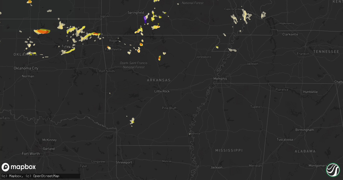
Hail Map in Arkansas on May 14, 2022
Get this storm
May 14 map
$229
one time, instant access
Download today. No call, no setup
Keep the $229
Bought the map and want the full workflow? Apply the entire $229 to a subscription within 7 days. None of it is wasted.
Every map, not just this one
This buys you this map. Subscription and you get every map we run, in the markets you choose from a few cities to whole states to nationwide. Plus real-time alerts the moment a storm fires.
Contact data
Name, contact info, occupancy, even credit band for addresses in the footprint. You go from where it hit to who to call.
Become the source they trust
Unlimited branding weather history reports on demand. You already have the documented answer ready for the property owner, and you are the one who showed up with it.
Property data and RoofTrace estimates
Pull up any address you have got, its value and the exact code rules for that jurisdiction, straight from One Click Code. Then RoofTrace estimates the squares, pitch, and roof value, priced the way you price.
Storm reports in Arkansas
Arkansas
| Date | Description |
|---|---|
| 05/14/20223:50 PM CDT | A local report indicates 2.00 inch wind near JASPER |
| 05/14/20223:44 PM CDT | *update* recieved a social media picture from jasper showing a mix of hail sizes... With the largest being two inches. |
| 05/14/20223:44 PM CDT | A local report indicates 1.00 inch wind near JASPER |
| 05/14/20223:40 PM CDT | Made a call to a local store north of jasper. |
| 05/14/20223:22 PM CDT | In the flatwoods area east of jasper... 1.6 inch hail was measured. |
| 05/14/20228:50 AM CDT | Quarter-sized hail reported just south of prescott. |
| 05/14/20224:43 AM CDT | At 943 PM CDT, a severe thunderstorm was located 5 miles southwest of Tontitown, moving south at 10 mph. HAZARD...Golf ball size hail and 60 mph wind gusts. SOURCE...Radar indicated. IMPACT...People and animals outdoors will be injured. Expect hail damage to roofs, siding, windows, and vehicles. Expect wind damage to roofs, siding, and trees. Locations in or near the path include... Farmington... Prairie Grove... Tontitown... Prairie Grove Battlefield State... Wedington... Gallitin... Rhea... Wheeler... Savoy... Viney Grove... |
| 05/14/20224:17 AM CDT | At 916 PM CDT, a severe thunderstorm was located 3 miles north of Farmington, moving south at 10 mph. HAZARD...60 mph wind gusts and quarter size hail. SOURCE...Radar indicated. IMPACT...Hail damage to vehicles is expected. Expect wind damage to roofs, siding, and trees. Locations in or near the path include... Fayetteville... Springdale... Farmington... Prairie Grove... Tontitown... West Fork... Greenland... Drake Field Airport... Johnson... Prairie Grove Battlefield State... Walnut Grove... Savoy... Wheeler... Viney Grove...This includes Interstate 49 between mile markers 55 and 70. |
| 05/14/20224:14 AM CDT | At 914 AM CDT, a severe thunderstorm was located near Prescott, moving southeast at 20 mph. HAZARD...60 mph wind gusts and quarter size hail. SOURCE...Radar indicated. IMPACT...Hail damage to vehicles is expected. Expect wind damage to roofs, siding, and trees. Locations impacted include... Gurdon... Whelen Springs... Beirne... This includes Interstate 30 between mile markers 53 and 58. |
| 05/14/20223:45 AM CDT | At 845 AM CDT, a severe thunderstorm was located near Prescott, moving east at 20 mph. HAZARD...60 mph wind gusts and half dollar size hail. SOURCE...Radar indicated. IMPACT...Hail damage to vehicles is expected. Expect wind damage to roofs, siding, and trees. Locations impacted include... Hope, Prescott, Emmet, Blevins, Perrytown, Bluff City, White Oak Lake State Park, Cale, Oakhaven, Boughton, Morris, Laneburg and Reader. |
| 05/14/20222:42 AM CDT | At 742 PM CDT, a severe thunderstorm was located near Valley Springs, or near Harrison, moving southeast at 15 mph. HAZARD...Quarter size hail. SOURCE...Radar indicated. IMPACT...Damage to vehicles is expected. Locations impacted include... Harrison... Western Grove... Valley Springs... Dugger... Olvey... Capps... Piercetown... Carver... Pruitt... Crawford... Bellefonte... Everton... St. Joe... Pindall... Marble Falls... Yardelle... Vendor... Gaither... Hasty... |
| 05/14/20222:39 AM CDT | At 739 PM CDT, a severe thunderstorm was located over Upper Buffalo Wilderness Area, or 16 miles west of Jasper, moving south at 10 mph. HAZARD...60 mph wind gusts and quarter size hail. SOURCE...Radar indicated. IMPACT...Hail damage to vehicles is expected. Expect wind damage to roofs, siding, and trees. Locations impacted include... Lost Valley State Park... Upper Buffalo Wilderness Area... Walnut... Wayton... Boxley... Mossville... Low Gap... Fallsville... Crossroad... Swain... Deer... Dixon Ridge... Nail... Arbaugh... Ponca... |
| 05/14/20222:35 AM CDT | At 735 PM CDT, a severe thunderstorm was located 4 miles west of Upper Buffalo Wilderness Area, moving south at 15 mph. HAZARD...60 mph wind gusts and quarter size hail. SOURCE...Radar indicated. IMPACT...Hail damage to vehicles is expected. Expect wind damage to roofs, siding, and trees. Locations in or near the path include... Kingston... Red Star... Weathers... |
| 05/14/20222:06 AM CDT | At 706 PM CDT, a severe thunderstorm was located over Bergman, or 8 miles northeast of Harrison, moving south at 20 mph. HAZARD...60 mph wind gusts and quarter size hail. SOURCE...Radar indicated. IMPACT...Hail damage to vehicles is expected. Expect wind damage to roofs, siding, and trees. Locations impacted include... Harrison... Bergman... Western Grove... Pyatt... Valley Springs... Dugger... Olvey... Myrtle... Willis... Crawford... Winington... Bellefonte... Everton... Pindall... Zinc... South Lead Hill... Hopewell in Boone County... Yardelle... Eros... Bruno... |
| 05/14/20221:26 AM CDT | At 626 PM CDT, a severe thunderstorm was located over Old Lexington, or 10 miles northwest of Fairfield Bay, moving south at 10 mph. HAZARD...60 mph wind gusts and quarter size hail. SOURCE...Radar indicated. IMPACT...Hail damage to vehicles is expected. Expect wind damage to roofs, siding, and trees. Locations impacted include... Clinton... Fairfield Bay... Shirley... Fairfield Bay Marina... Elba... Sugar Loaf Recreation Area... Old Lexington... Choctaw... Alco... Rushing... Oxley... Flag... Arlberg... Fox... South Fork Recreation Area... Timbo... Botkinburg... Crabtree... Choctow Recreation Area... Culpepper... |
| 05/14/202212:54 AM CDT | At 553 AM CDT, a severe thunderstorm was located over Sylvan Hills, or over Sherwood, moving east at 15 mph. Dime sized hail was falling at the National Weather Service office at the North Little Rock Airport. HAZARD...60 mph wind gusts and quarter size hail. SOURCE...Radar indicated. IMPACT...Hail damage to vehicles is expected. Expect wind damage to roofs, siding, and trees. Locations impacted include... Little Rock... North Little Rock... Sherwood... Jacksonville... North Little Rock Airport... Little Rock AFB... Argenta... Burns Park... Gravel Ridge... Protho Junction... Gibson... Lakewood... Camp Robinson... Sylvan Hills... Levy... McAlmont... Scott... Oak Grove in Pulaski County... Amboy... Baucum...This includes the following highways... Interstate 30 near mile marker 142. Interstate 40 between mile markers 148 and 163. Interstate 440 between mile markers 6 and 14. US Highway 67 between mile markers 1 and 12. |
| 05/14/202212:54 AM CDT | At 553 PM CDT, a severe thunderstorm was located 7 miles northeast of Elba, or 12 miles west of Mountain View, and is nearly stationary. HAZARD...60 mph wind gusts and quarter size hail. SOURCE...Radar indicated. IMPACT...Hail damage to vehicles is expected. Expect wind damage to roofs, siding, and trees. Locations impacted include... Old Lexington... Parma... Rushing... Turkey Creek... Timbo... Flag... Arlberg... Fox... |
| 05/14/202212:19 AM CDT | At 518 AM CDT, a severe thunderstorm was located 3 miles southeast of Mulberry, moving southeast at 15 mph. HAZARD...Quarter size hail. SOURCE...Radar indicated. IMPACT...Damage to vehicles is expected. Locations in or near the path include... Ozark... Mulberry... Dyer... Altus... Branch... Denning... Etna... Meg... Piney... Toney... Peter Pender... Cecil... Lonelm... This includes Interstate 40 in Arkansas between mile markers 16 and30. |
| 05/13/202211:49 PM CDT | At 449 PM CDT, a severe thunderstorm was located near Blanchard Springs Campground, or near Mountain View, moving southeast at 5 mph. HAZARD...60 mph wind gusts and quarter size hail. SOURCE...Radar indicated. IMPACT...Hail damage to vehicles is expected. Expect wind damage to roofs, siding, and trees. Locations impacted include... Mountain View... Herpel... Brandenberg... Croker... Blanchard Springs Campground... Guion... Allison... Parma... Hanover... Turkey Creek... Mt Olive in Izard County... Luber... Fifty-Six... Twin Creek... Sylamore Bike Trail... Sylamore... Sylamore Shooting Range... Newnata... Gunner Pool Campground... Lafferty... |
| 05/13/202211:41 PM CDT | At 440 AM CDT, a severe thunderstorm was located near Bonanza, and is nearly stationary. HAZARD...Half dollar size hail. SOURCE...Radar indicated. IMPACT...Damage to vehicles is expected. Locations in or near the path include... Fort Smith... Greenwood... Barling... Pocola... Arkoma... Hackett... Bonanza... Cameron... Excelsior... Fort Smith Regional Airport... Jenny Lind... Rock Island... Central City... Scullyville... Witcherville... Braden... Mill Creek... Rye Hill... Jenson... This includes Interstate 540 between mile markers 10 and 14. |
| 05/13/202210:58 PM CDT | At 357 AM CDT, a severe thunderstorm was located over Jenny Lind, moving southeast at 5 mph. HAZARD...60 mph wind gusts and half dollar size hail. SOURCE...Radar indicated. IMPACT...Hail damage to vehicles is expected. Expect wind damage to roofs, siding, and trees. Locations in or near the path include... Fort Smith... Greenwood... Barling... Lavaca... Hackett... Bonanza... Bloomer... Excelsior... Fort Smith Regional Airport... Burnville... Jenny Lind... Central City... Crossroads... Witcherville... Mill Creek... Rye Hill... Milltown... Ursula...This includes Interstate 540 between mile markers 10 and 14. |
| 05/13/202210:32 PM CDT | At 332 PM CDT, a severe thunderstorm was located over Pruitt, or near Jasper, moving south at 10 mph. HAZARD...60 mph wind gusts and quarter size hail. SOURCE...Radar indicated. IMPACT...Hail damage to vehicles is expected. Expect wind damage to roofs, siding, and trees. Locations impacted include... Jasper... Piercetown... Carver... Erbie... Pruitt... Bass... Wayton... Marble Falls... Crossroad... Vendor... Parthenon... Gum Springs in Newton County... Mt Judea... Deer... Hasty... Mt Sherman... Cowell... |
| 05/13/202210:20 PM CDT | At 320 AM CDT, a severe thunderstorm was located near Jenny Lind, moving east at 5 mph. HAZARD...60 mph wind gusts and half dollar size hail. SOURCE...Radar indicated. IMPACT...Hail damage to vehicles is expected. Expect wind damage to roofs, siding, and trees. Locations in or near the path include... Fort Smith... Greenwood... Barling... Lavaca... Hackett... Bonanza... Bloomer... Excelsior... Fort Smith Regional Airport... Burnville... Jenny Lind... Central City... Rye Hill... This includes Interstate 540 between mile markers 12 and 14. |
| 05/13/20229:50 PM CDT | Ping pong ball size hail fell near savoy. |
| 05/13/20227:45 PM CDT | A local report indicates 1.75 inch wind near HARRISON |
All States Impacted by Hail Map on May 14, 2022
Cities Impacted by Hail Map on May 14, 2022
- Hot Springs, SD
- Grand Blanc, MI
- Shenandoah, IA
- Roachdale, IN
- Perrinton, MI
- Ashley, MI
- Hubbardston, MI
- Adrian, MI
- Manitou Beach, MI
- Onsted, MI
- Brighton, MI
- Howell, MI
- Cuba, KS
- Belleville, KS
- Harlan, IA
- Baileyville, KS
- Axtell, KS
- Harrisville, NY
- Kendallville, IN
- Ionia, MI
- Muir, MI
- Michigantown, IN
- Frankfort, IN
- Odon, IN
- Montgomery, IN
- Plainville, IN
- Grass Lake, MI
- Stockbridge, MI
- Munith, MI
- Saint Charles, MI
- Chesaning, MI
- Plainfield, IN
- Uniontown, OH
- Mogadore, OH
- Akron, OH
- Bison, KS
- Rush Center, KS
- La Crosse, KS
- Stockton, KS
- Logan, KS
- Lenora, KS
- Bogue, KS
- Bladen, NE
- Minden, NE
- Heartwell, NE
- Holstein, NE
- Roseland, NE
- Glenvil, NE
- Kenesaw, NE
- Ayr, NE
- Blue Hill, NE
- Lawrence, NE
- Belleville, IL
- Onaway, MI
- Bicknell, IN
- Edwardsport, IN
- Jacob, IL
- Gorham, IL
- Wapakoneta, OH
- Salvisa, KY
- Harrodsburg, KY
- Corning, KS
- Willisburg, KY
- Mackville, KY
- Percy, IL
- Steeleville, IL
- Afton, OK
- Chelsea, OK
- Big Cabin, OK
- Pryor, OK
- Claremore, OK
- Jay, OK
- Ketchum, OK
- Strang, OK
- Vinita, OK
- Adair, OK
- Eucha, OK
- Grove, OK
- Waverly, KY
- Morganfield, KY
- Uniontown, KY
- Bedford, IN
- Mitchell, IN
- Park Hills, MO
- Farmington, MO
- Griffin, IN
- Poseyville, IN
- Roscommon, MI
- Wakeeney, KS
- Chester, IL
- Warsaw, IN
- Ligonier, IN
- Albion, IN
- Cromwell, IN
- Pierceton, IN
- Larwill, IN
- North Webster, IN
- Leesburg, IN
- Kimmell, IN
- Saint Joe, IN
- Butler, IN
- Auburn, IN
- Atlanta, MI
- Lewiston, MI
- Saint Peter, IL
- Westfield, IL
- Martinsville, IL
- Casey, IL
- Orient, IA
- Fontanelle, IA
- Tipton, MI
- Tecumseh, MI
- Riley, KS
- Unionville, MI
- Sebewaing, MI
- Bluffton, OH
- Mount Pleasant, MI
- Rosebush, MI
- Coleman, MI
- Ann Arbor, MI
- Geneseo, KS
- Little River, KS
- Westphalia, IN
- Carlisle, IN
- Sandborn, IN
- Gentryville, IN
- Bannister, MI
- Steelville, MO
- Cuba, MO
- Ithaca, MI
- Elnora, IN
- Utica, OH
- Olive Hill, KY
- Sandy Hook, KY
- Webbville, KY
- Blaine, KY
- Isonville, KY
- Terre Haute, IN
- West Terre Haute, IN
- Canton, OH
- North Canton, OH
- Murphysboro, IL
- Carbondale, IL
- Pinckneyville, IL
- Ava, IL
- Campbell Hill, IL
- Makanda, IL
- Montezuma, IN
- Hillsdale, IN
- Bloomingdale, IN
- Rockville, IN
- Waynesville, MO
- Richland, MO
- Laquey, MO
- Fort Leonard Wood, MO
- Falcon, MO
- Lebanon, MO
- Grovespring, MO
- Saginaw, MI
- Medina, OH
- Hinckley, OH
- Washington, IN
- Holly, MI
- Martinsville, IN
- Cincinnati, OH
- Mcpherson, KS
- Galva, KS
- Solsberry, IN
- Bloomfield, IN
- Fairgrove, MI
- Akron, MI
- Rhodes, MI
- Beaverton, MI
- Hope, MI
- Danville, OH
- Walhonding, OH
- Beattie, KS
- Morland, KS
- Hill City, KS
- Elm Creek, NE
- Kearney, NE
- Campbell, NE
- Guide Rock, NE
- Hildreth, NE
- Cozad, NE
- Wilcox, NE
- Funk, NE
- Smithfield, NE
- Bertrand, NE
- Gothenburg, NE
- Red Cloud, NE
- Willow Island, NE
- Axtell, NE
- Elwood, NE
- Riverton, NE
- Loomis, NE
- Overton, NE
- Lexington, NE
- Upland, NE
- Holdrege, NE
- Morehead, KY
- Larned, KS
- Prairie Du Rocher, IL
- Fults, IL
- Washington Court House, OH
- Clayton, MI
- Salem, MO
- Evansville, IL
- Ellis Grove, IL
- Centralia, KS
- Vermillion, KS
- Seneca, KS
- Goff, KS
- Perry, OK
- Wolcottville, IN
- South Milford, IN
- Drury, MO
- Killbuck, OH
- Grandview, IN
- Chatom, AL
- Tibbie, AL
- Wagarville, AL
- Carroll, IA
- Templeton, IA
- Dedham, IA
- Netawaka, KS
- Cummings, KS
- Everest, KS
- Atchison, KS
- Lancaster, KS
- Powhattan, KS
- Whiting, KS
- Sabetha, KS
- Wetmore, KS
- Effingham, KS
- Horton, KS
- Tye, TX
- Merkel, TX
- Cannelburg, IN
- Loogootee, IN
- Hesston, KS
- Moundridge, KS
- Cuttingsville, VT
- Seville, OH
- Lodi, OH
- Chippewa Lake, OH
- Almena, KS
- Norton, KS
- Prairie View, KS
- Phillipsburg, KS
- Glade, KS
- Montrose, MI
- Hamburg, IA
- Burton, OH
- Alpena, MI
- Lachine, MI
- Herron, MI
- Portsmouth, IA
- Woodbine, IA
- Panama, IA
- Edon, OH
- Hamilton, IN
- Caledonia, MO
- Belleview, MO
- Belgrade, MO
- Potosi, MO
- Kingston, MI
- Caro, MI
- Osceola, IA
- Grayville, IL
- Crossville, IL
- Bern, KS
- Campbellsburg, IN
- Salem, IN
- Pratt, KS
- Grayling, MI
- Johannesburg, MI
- Silver Lake, IN
- Akron, IN
- Pandora, OH
- Ottawa, OH
- Brookston, IN
- West Lafayette, IN
- Battle Ground, IN
- Manning, IA
- Audubon, IA
- Harrison, MI
- Cass City, MI
- Farragut, IA
- Riverton, IA
- Sidney, IA
- Arcanum, OH
- Lewisburg, OH
- Smith Center, KS
- Athol, KS
- Clarinda, IA
- Essex, IA
- Morenci, MI
- Fayette, OH
- Hudson, MI
- Beatrice, NE
- De Witt, NE
- Soldier, KS
- Haddam, KS
- Montezuma, KS
- Ingalls, KS
- Cimarron, KS
- Ensign, KS
- Fowler, KS
- Meade, KS
- Plains, KS
- Colton, NY
- Scandia, KS
- Hamilton, OH
- Fairfield, OH
- Okeana, OH
- Edgerton, OH
- West Harrison, IN
- Cedar Grove, IN
- Bay City, MI
- Nebraska City, NE
- Talmage, NE
- Dunbar, NE
- Lorton, NE
- Red Oak, IA
- Eustis, NE
- Farnam, NE
- Wheeling, MO
- Linneus, MO
- Lueders, TX
- Romney, IN
- Lafayette, IN
- McIntosh, AL
- Hornbeak, TN
- Union City, TN
- Loxley, AL
- Alexander, KS
- Burdett, KS
- Rozel, KS
- Ness City, KS
- Nekoma, KS
- Collyer, KS
- Utica, KS
- Ransom, KS
- Bazine, KS
- Brownell, KS
- Garfield, KS
- Sterling, NE
- Burr, NE
- Syracuse, NE
- Cook, NE
- Broken Arrow, OK
- Worthington, IN
- Berryville, AR
- Green Forest, AR
- Pawhuska, OK
- Bartlesville, OK
- Garfield, AR
- Rogers, AR
- Sand Springs, OK
- Noble, MO
- Thornfield, MO
- Wasola, MO
- Brixey, MO
- Squires, MO
- Gainesville, MO
- Mulhall, OK
- Marshall, OK
- Sapulpa, OK
- Harrison, AR
- Butler, AL
- Salina, KS
- Hartville, MO
- New Albany, IN
- Louisville, KY
- Coyle, OK
- Guthrie, OK
- Perkins, OK
- Fort Lauderdale, FL
- Fordland, MO
- Seymour, MO
- Hays, KS
- Olmsted, IL
- Utica, KY
- Philpot, KY
- Friendship, TN
- Finley, TN
- Alma, KS
- Belpre, KS
- Buffalo, OK
- Boca Raton, FL
- Delray Beach, FL
- Wingate, TX
- Fredericktown, MO
- Manhattan, KS
- Taneyville, MO
- Forsyth, MO
- Charleston, MO
- Hardtner, KS
- Hanson, KY
- Manitou, KY
- Saint Clair, MO
- Sullivan, MO
- Bourbon, MO
- Marble Falls, AR
- Citronelle, AL
- Deer Park, AL
- Powersite, MO
- Kirbyville, MO
- Bixby, MO
- Patoka, IN
- Princeton, IN
- Barlow, KY
- Wickliffe, KY
- Sturgis, KY
- Lewis, KS
- Fifty Six, AR
- Mountain View, AR
- Timbo, AR
- Smithland, KY
- Kinsley, KS
- Pawnee City, NE
- Delta, OH
- Rockwood, IL
- Tulsa, OK
- Matthews, MO
- Kevil, KY
- Bardwell, KY
- Branson, MO
- Hollister, MO
- Kingston, AR
- Monrovia, IN
- Clayton, IN
- Mooresville, IN
- Hartford, KY
- Whitesville, KY
- Haviland, KS
- Marlette, MI
- Decker, MI
- Cayuga, IN
- Duke, MO
- Newburg, MO
- Edgar Springs, MO
- Collinsville, OK
- Sperry, OK
- Colcord, OK
- Poplarville, MS
- Leasburg, MO
- Springville, IN
- Benton, MO
- Haysville, KS
- Alva, OK
- Clinton, AR
- Wamego, KS
- Saint George, KS
- Greensburg, KS
- Offerle, KS
- Hanston, KS
- Coats, KS
- Randolph, KS
- Leonardville, KS
- New Harmony, IN
- Mount Vernon, IN
- Wadesville, IN
- Percival, IA
- McCaskill, AR
- New Holland, OH
- Medicine Lodge, KS
- Sharon, KS
- Bonne Terre, MO
- Beulah, MO
- Rolla, MO
- Murray, KY
- Dexter, KY
- Burlington, OK
- Kiowa, KS
- Evansville, IN
- Stroud, OK
- Gravette, AR
- Covington, OK
- Lucien, OK
- Hampton, KY
- Bloomsdale, MO
- Lometa, TX
- Bend, TX
- San Saba, TX
- Sedan, KS
- Ava, MO
- Stillwater, OK
- Ramona, OK
- Bertrand, MO
- Eskridge, KS
- Ahoskie, NC
- Pass Christian, MS
- Gulfport, MS
- Perryville, MO
- Jasper, AR
- Witter, AR
- Kissee Mills, MO
- Lisman, AL
- Bronte, TX
- Gideon, MO
- Mansfield, MO
- Ponca City, OK
- May, OK
- Laverne, OK
- Rosston, OK
- Cedarcreek, MO
- Spencer, IN
- Prospect, KY
- Slaughters, KY
- Sebree, KY
- Providence, KY
- Dixon, KY
- Henderson, KY
- Robards, KY
- Corydon, KY
- Nebo, KY
- Madisonville, KY
- West Chester, OH
- Ellis, KS
- Pomona, IL
- Frankfort, KY
- Bagdad, KY
- Nowata, OK
- Delaware, OK
- Ochelata, OK
- Talala, OK
- East Prairie, MO
- Edmonton, KY
- Knob Lick, KY
- Glasgow, KY
- Oologah, OK
- Ponca, AR
- Sun City, KS
- Belle Plaine, KS
- Macomb, MO
- Norwood, MO
- Universal, IN
- Clinton, IN
- Silverhill, AL
- Robertsdale, AL
- Owensburg, IN
- Burlison, TN
- Atoka, TN
- Drummonds, TN
- Millington, TN
- Brighton, TN
- Munford, TN
- Coffeeville, AL
- Bogue Chitto, MS
- Murfreesboro, TN
- Macksville, KS
- Oldfield, MO
- Sparta, MO
- Bruner, MO
- Senath, MO
- Hornersville, MO
- Mountain Grove, MO
- Sikeston, MO
- Emmet, AR
- Prescott, AR
- Minneola, KS
- Englewood, KS
- Ashland, KS
- Marland, OK
- Fairfax, OK
- Ralston, OK
- Carriere, MS
- Picayune, MS
- Saint Martinville, LA
- Breaux Bridge, LA
- Minneapolis, KS
- Beverly, KS
- Tescott, KS
- Sylvan Grove, KS
- Lincoln, KS
- Red Bud, IL
- Spavinaw, OK
- Ridgely, TN
- Sandy Hook, MS
- Grand Rivers, KY
- Lincoln, AR
- Fayetteville, AR
- Frankville, AL
- Lake Village, AR
- Leslie, AR
- Gilbertown, AL
- Toxey, AL
- Patton, MO
- Parkers Lake, KY
- Waynoka, OK
- Dyersburg, TN
- Derby, KS
- Saint James, MO
- Ledbetter, KY
- Brookport, IL
- Hickman, KY
- Bingham, IL
- Fillmore, IL
- Witt, IL
- Nokomis, IL
- Irving, IL
- Tiline, KY
- Burna, KY
- Calvert City, KY
- Benton, KY
- Bixby, OK
- Glenpool, OK
- Mounds, OK
- Jenks, OK
- Kiefer, OK
- Oran, MO
- Houghton Lake, MI
- Prudenville, MI
- Chandler, OK
- Jupiter, FL
- Palm Beach Gardens, FL
- Cabool, MO
- Hope, AR
- Saint Stephens, AL
- La Center, KY
- Villa Ridge, IL
- West Palm Beach, FL
- Loxahatchee, FL
- Bradleyville, MO
- Tryon, OK
- Agra, OK
- Anna, IL
- Dongola, IL
- Chunchula, AL
- Cambridge, KS
- Dexter, KS
- Cedar Vale, KS
- Crescent, OK
- Orlando, OK
- Peck, KS
- Clearwater, KS
- Owensville, IN
- Muscotah, KS
- Holton, KS
- Modoc, IL
- Mulvane, KS
- Parma, MO
- Pond Creek, OK
- Hunter, OK
- Caruthersville, MO
- Huntsville, AR
- Catoosa, OK
- Jachin, AL
- Crane, IN
- Shirley, AR
- Obion, TN
- Mena, AR
- Lead Hill, AR
- Blue Eye, MO
- Lebanon, TN
- Compton, AR
- Owasso, OK
- Orleans, IN
- Abilene, TX
- Wilmer, AL
- Paxico, KS
- McFarland, KS
- Viburnum, MO
- Farmington, AR
- Fort Supply, OK
- South West City, MO
- Boykins, VA
- Fairview, OK
- Ullin, IL
- Mound City, IL
- Grand Chain, IL
- Mounds, IL
- Pulaski, IL
- Clay, KY
- Mcminnville, TN
- Calhoun, KY
- Fenwick, MI
- Deweese, NE
- Ossineke, MI
- Nelson, NE
- Hubbard Lake, MI
- Oak, NE
- Ellettsville, IN
- Siloam Springs, AR
- Fox, AR
- Burbank, OK
- Chadwick, MO
- Rogersville, MO
- Garrison, MO
- Vanzant, MO
- Woodston, KS
- Sawyer, KS
- Wichita, KS


