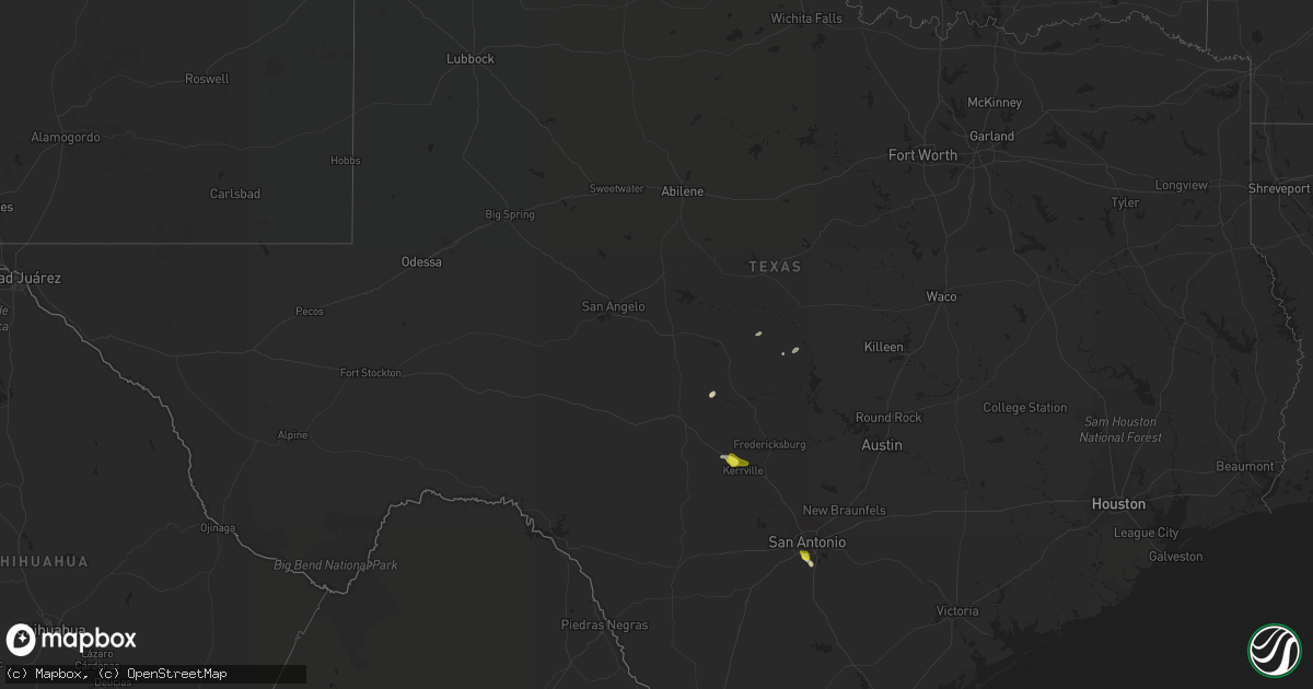
Hail Map in Texas on May 14, 2019
Get this storm
May 14 map
$229
one time, instant access
Download today. No call, no setup
Keep the $229
Bought the map and want the full workflow? Apply the entire $229 to a subscription within 7 days. None of it is wasted.
Every map, not just this one
This buys you this map. Subscription and you get every map we run, in the markets you choose from a few cities to whole states to nationwide. Plus real-time alerts the moment a storm fires.
Contact data
Name, contact info, occupancy, even credit band for addresses in the footprint. You go from where it hit to who to call.
Become the source they trust
Unlimited branding weather history reports on demand. You already have the documented answer ready for the property owner, and you are the one who showed up with it.
Property data and RoofTrace estimates
Pull up any address you have got, its value and the exact code rules for that jurisdiction, straight from One Click Code. Then RoofTrace estimates the squares, pitch, and roof value, priced the way you price.
Storm reports in Texas
Texas
| Date | Description |
|---|---|
| 05/14/20197:46 AM CDT | At 1245 PM CDT, a severe thunderstorm was located near Ingram, or near Kerrville, moving east at 25 mph. HAZARD...Quarter size hail. SOURCE...Radar indicated. IMPACT...Damage to vehicles is expected. Locations impacted include... Kerrville, Fredericksburg, Ingram, Cypress Creek, Tivydale and Harper. |
| 05/14/20197:27 AM CDT | At 1227 AM CDT, a severe thunderstorm was located 12 miles northeast of Chupadera Ranch Airport, or 13 miles southwest of Carrizo Springs, moving east at 20 mph. HAZARD...60 mph wind gusts and quarter size hail. SOURCE...Radar indicated. IMPACT...Hail damage to vehicles is expected. Expect wind damage to roofs, siding, and trees. Locations impacted include... Asherton, Gilson Groves and Catarina. |
| 05/14/20197:17 AM CDT | At 1217 PM CDT, a severe thunderstorm was located near Guillermo Flores Elementary School, or near Penitas, moving east at 30 mph. HAZARD...60 mph wind gusts and half dollar size hail. SOURCE...Radar indicated. IMPACT...Hail damage to vehicles is expected. Expect wind damage to roofs, siding, and trees. Locations impacted include... Mission, Hidalgo, Palmview, Penitas, La Joya, Palmhurst, South McAllen, North McAllen, Sharyland and Rio Grande Regional Hospital.This includes US Highway 83 between mile markers 846 and 850. |
| 05/14/20194:01 AM CDT | At 900 PM CDT, a severe thunderstorm was located over Stinson Municipal Airport, moving southeast at 10 mph. HAZARD...60 mph wind gusts and quarter size hail. SOURCE...Radar indicated. IMPACT...Hail damage to vehicles is expected. Expect wind damage to roofs, siding, and trees. Locations impacted include... San Antonio, Stinson Municipal Airport, Elmendorf, Sandy Oaks, Buena Vista, Mitchell Lake, Losoya, Southton, Thelma and Braunig Lake. |
| 05/14/20191:17 AM CDT | At 616 AM CDT, a severe thunderstorm was located over La Rosita, moving northeast at 35 mph. HAZARD...Golf ball size hail and 60 mph wind gusts. SOURCE...Radar indicated. IMPACT...People and animals outdoors will be injured. Expect hail damage to roofs, siding, windows, and vehicles. Expect wind damage to roofs, siding, and trees. Locations impacted include... Roma, Escobares, La Rosita, El Sauz, Roma Creek, Roma High School, Los Alvarez, Garceno, Roma City Hall and Rio Grande City Municipal Airport.This includes US Highway 83 between mile markers 802 and 806, andbetween mile markers 810 and 816. |
| 05/14/201912:46 AM CDT | At 544 AM CDT, a severe thunderstorm was located over Monte Alto, or near Elsa, moving northeast at 35 mph. HAZARD...60 mph wind gusts and half dollar size hail. SOURCE...Public reported quarter size hail at 515 AM with storm as it moved through Alamo. IMPACT...Hail damage to vehicles is expected. Expect wind damage to roofs, siding, and trees. Locations impacted include... Raymondville, Elsa, Edcouch, La Villa, Hargill, Lasara, La Blanca, Edcouch-Elsa High School, La Villa High School and Edcouch Police Department.This includes Interstate Highway 69 E between mile markers 48 and 50. |
| 05/14/201912:25 AM CDT | At 524 AM CDT, a severe thunderstorm was located over North Alamo, or over Alamo, moving northeast at 25 mph. HAZARD...Golf ball size hail and 60 mph wind gusts. SOURCE...Radar indicated. IMPACT...People and animals outdoors will be injured. Expect hail damage to roofs, siding, windows, and vehicles. Expect wind damage to roofs, siding, and trees. Locations impacted include... Weslaco, San Juan, Alamo, Donna, Elsa, Edcouch, La Villa, Cesar Chavez, Maria Alicia P Munoz Elementary School and Los Lagos Golf Course.This includes Interstate Highway 69 C near mile marker 5. |
| 05/13/201911:44 PM CDT | At 444 AM CDT, a severe thunderstorm was located 8 miles south of Hidalgo High School, or 8 miles south of Hidalgo, moving northeast at 30 mph. HAZARD...Golf ball size hail and 60 mph wind gusts. SOURCE...Radar indicated. IMPACT...People and animals outdoors will be injured. Expect hail damage to roofs, siding, windows, and vehicles. Expect wind damage to roofs, siding, and trees. Locations impacted include... Pharr, Weslaco, San Juan, Alamo, Donna, Hidalgo, North McAllen, South McAllen, Edinburg Regional Medical Center and Austin Middle School.This includes the following highways... Interstate Highway 69 C between mile markers 1 and 4. US Highway 281 between mile markers 784 and 800. |
| 05/13/20199:05 PM CDT | Pictures via twitter of damage to porch awning as well as section of wooden fences blown down. |
| 05/13/20198:29 PM CDT | At 129 PM CDT, a severe thunderstorm was located over Progreso City Offices, or over Progreso, moving east at 30 mph. HAZARD...60 mph wind gusts and quarter size hail. SOURCE...Radar indicated. IMPACT...Hail damage to vehicles is expected. Expect wind damage to roofs, siding, and trees. Locations impacted include... Progreso, Los Indios, Santa Maria, Rangerville, Progreso City Offices, Progreso High School, Relampago, Villa Verde, Las Rusias and Santa Maria High School.This includes US Highway 281 between mile markers 800 and 822. |
All States Impacted by Hail Map on May 14, 2019
Cities Impacted by Hail Map on May 14, 2019
- Elk River, MN
- Anoka, MN
- Hill City, SD
- Alma, NE
- Holdrege, NE
- Chillicothe, MO
- Trenton, MO
- Jamesport, MO
- Dawn, MO
- Ludlow, MO
- Cameron, MO
- Osborn, MO
- Maysville, MO
- Mooresville, MO
- Utica, MO
- Bogard, MO
- Carrollton, MO
- Upland, NE
- Campbell, NE
- Eureka, MO
- Pacific, MO
- Labadie, MO
- Whitney, NE
- Harrison, NE
- Donna, TX
- Weslaco, TX
- Ashton, IA
- Sibley, IA
- Adrian, MN
- Rushmore, MN
- Roundup, MT
- Saint Albans, MO
- High Ridge, MO
- Gray Summit, MO
- Slater, MO
- Gilliam, MO
- Glasgow, MO
- Scandia, KS
- Rushville, MO
- Saint Joseph, MO
- Norway, KS
- Belleville, KS
- Courtland, KS
- Freeburg, IL
- Mascoutah, IL
- Andover, MN
- Cummings, KS
- Atchison, KS
- Sumner, MO
- Brookfield, MO
- Mendon, MO
- Rothville, MO
- Laclede, MO
- Lawrence, NE
- Blue Hill, NE
- Guide Rock, NE
- Bland, MO
- Belle, MO
- Lance Creek, WY
- Progreso, TX
- Mercedes, TX
- Alamo, TX
- San Juan, TX
- Perry, MO
- Santa Fe, MO
- Amity, MO
- Sundance, WY
- San Antonio, TX
- Edgemont, SD
- Belleville, IL
- East Carondelet, IL
- Saint Louis, MO
- Columbia, IL
- Millstadt, IL
- Wathena, KS
- De Kalb, MO
- Sheldon, IA
- Tuscumbia, MO
- Kaiser, MO
- Mankato, KS
- Webber, KS
- Burr Oak, KS
- Gower, MO
- Hildreth, NE
- Franklin, NE
- Meadville, MO
- Crawford, NE
- San Saba, TX
- Burfordville, MO
- Whitewater, MO
- Braymer, MO
- Weston, MO
- Dearborn, MO
- Western Grove, AR
- Saint Joe, AR
- Washington, MO
- Little Rock, IA
- Bladen, NE
- Gallatin, MO
- Jameson, MO
- Iberia, MO
- Crocker, MO
- Saint Clair, MO
- California, MO
- Orlando, FL
- Lenzburg, IL
- Sanborn, IA
- Archer, IA
- Polk City, FL
- Piedmont, SD
- Denton, KS
- Lancaster, KS
- Kerrville, TX
- Republic, KS
- Hardy, NE
- Mason, TX
- Brumley, MO
- Eldon, MO
- Ulman, MO
- Devils Tower, WY
- Tina, MO
- Ingram, TX
- Harper, TX
- Davenport, FL
- Chula, MO
- Spickard, MO
- Superior, NE
- Troy, KS
- Sturgis, SD
- Augusta, MO
- Ballwin, MO
- Marthasville, MO
- Villa Ridge, MO
- Wildwood, MO
- Fenton, MO
- House Springs, MO
- Woodstock, MN
- Easton, MO
- Stewartsville, MO
- Marble Hill, MO
- Galt, MO
- Mountain Home, TX
- Lismore, MN
- Franklin, MO
- Clyde, KS
- Clifton, KS
- Camdenton, MO
- Linn Creek, MO
- Red Cloud, NE
- Formoso, KS
- De Witt, MO
- Miami, MO
- Laddonia, MO
- Morganville, KS
- Salisbury, MO
- Wilcox, NE
- Platte City, MO
- Osage Beach, MO
- Rocky Mount, MO
- Lake Ozark, MO
- Agenda, KS
- Gravois Mills, MO
- Winchester, KS
- Hay Springs, NE
- Plattsburg, MO
- Brunswick, MO
- Dupo, IL
- Edinburg, TX
- Elsa, TX
- Pharr, TX
- Edcouch, TX


