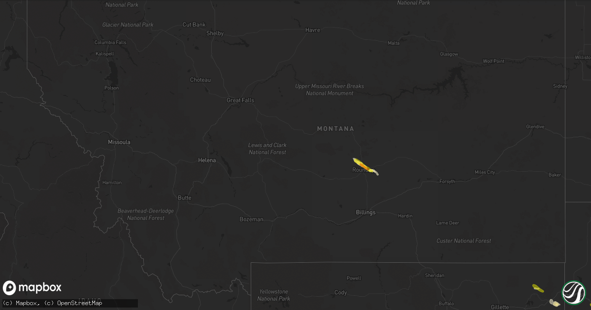
Hail Map in Montana on May 14, 2019
Get this storm
May 14 map
$229
one time, instant access
Download today. No call, no setup
Keep the $229
Bought the map and want the full workflow? Apply the entire $229 to a subscription within 7 days. None of it is wasted.
Every map, not just this one
This buys you this map. Subscription and you get every map we run, in the markets you choose from a few cities to whole states to nationwide. Plus real-time alerts the moment a storm fires.
Contact data
Name, contact info, occupancy, even credit band for addresses in the footprint. You go from where it hit to who to call.
Become the source they trust
Unlimited branding weather history reports on demand. You already have the documented answer ready for the property owner, and you are the one who showed up with it.
Property data and RoofTrace estimates
Pull up any address you have got, its value and the exact code rules for that jurisdiction, straight from One Click Code. Then RoofTrace estimates the squares, pitch, and roof value, priced the way you price.
Storm reports in Montana
Montana
| Date | Description |
|---|---|
| 05/14/20195:05 PM CDT | Average hail size was penny. |
| 05/14/20194:53 PM CDT | Roofs and siding damaged. At least 6 solarium windows broke. |
| 05/14/20191:53 PM CDT | A local report indicates 58 MPH wind near 6 ENE LIVINGSTON |
| 05/13/201911:34 PM CDT | At 434 PM MDT, a severe thunderstorm was located 9 miles east of Roundup, moving southeast at 25 mph. HAZARD...60 mph wind gusts and half dollar size hail. SOURCE...Radar indicated. IMPACT...Hail damage to vehicles is expected. Expect wind damage to roofs, siding, and trees. This severe thunderstorm will remain over mainly rural areas of southeastern Musselshell County. |
| 05/13/201911:15 PM CDT | A local report indicates 58 MPH wind near 3 ENE LIVINGSTON |
All States Impacted by Hail Map on May 14, 2019
Cities Impacted by Hail Map on May 14, 2019
- Elk River, MN
- Anoka, MN
- Hill City, SD
- Alma, NE
- Holdrege, NE
- Chillicothe, MO
- Trenton, MO
- Jamesport, MO
- Dawn, MO
- Ludlow, MO
- Cameron, MO
- Osborn, MO
- Maysville, MO
- Mooresville, MO
- Utica, MO
- Bogard, MO
- Carrollton, MO
- Upland, NE
- Campbell, NE
- Eureka, MO
- Pacific, MO
- Labadie, MO
- Whitney, NE
- Harrison, NE
- Donna, TX
- Weslaco, TX
- Ashton, IA
- Sibley, IA
- Adrian, MN
- Rushmore, MN
- Roundup, MT
- Saint Albans, MO
- High Ridge, MO
- Gray Summit, MO
- Slater, MO
- Gilliam, MO
- Glasgow, MO
- Scandia, KS
- Rushville, MO
- Saint Joseph, MO
- Norway, KS
- Belleville, KS
- Courtland, KS
- Freeburg, IL
- Mascoutah, IL
- Andover, MN
- Cummings, KS
- Atchison, KS
- Sumner, MO
- Brookfield, MO
- Mendon, MO
- Rothville, MO
- Laclede, MO
- Lawrence, NE
- Blue Hill, NE
- Guide Rock, NE
- Bland, MO
- Belle, MO
- Lance Creek, WY
- Progreso, TX
- Mercedes, TX
- Alamo, TX
- San Juan, TX
- Perry, MO
- Santa Fe, MO
- Amity, MO
- Sundance, WY
- San Antonio, TX
- Edgemont, SD
- Belleville, IL
- East Carondelet, IL
- Saint Louis, MO
- Columbia, IL
- Millstadt, IL
- Wathena, KS
- De Kalb, MO
- Sheldon, IA
- Tuscumbia, MO
- Kaiser, MO
- Mankato, KS
- Webber, KS
- Burr Oak, KS
- Gower, MO
- Hildreth, NE
- Franklin, NE
- Meadville, MO
- Crawford, NE
- San Saba, TX
- Burfordville, MO
- Whitewater, MO
- Braymer, MO
- Weston, MO
- Dearborn, MO
- Western Grove, AR
- Saint Joe, AR
- Washington, MO
- Little Rock, IA
- Bladen, NE
- Gallatin, MO
- Jameson, MO
- Iberia, MO
- Crocker, MO
- Saint Clair, MO
- California, MO
- Orlando, FL
- Lenzburg, IL
- Sanborn, IA
- Archer, IA
- Polk City, FL
- Piedmont, SD
- Denton, KS
- Lancaster, KS
- Kerrville, TX
- Republic, KS
- Hardy, NE
- Mason, TX
- Brumley, MO
- Eldon, MO
- Ulman, MO
- Devils Tower, WY
- Tina, MO
- Ingram, TX
- Harper, TX
- Davenport, FL
- Chula, MO
- Spickard, MO
- Superior, NE
- Troy, KS
- Sturgis, SD
- Augusta, MO
- Ballwin, MO
- Marthasville, MO
- Villa Ridge, MO
- Wildwood, MO
- Fenton, MO
- House Springs, MO
- Woodstock, MN
- Easton, MO
- Stewartsville, MO
- Marble Hill, MO
- Galt, MO
- Mountain Home, TX
- Lismore, MN
- Franklin, MO
- Clyde, KS
- Clifton, KS
- Camdenton, MO
- Linn Creek, MO
- Red Cloud, NE
- Formoso, KS
- De Witt, MO
- Miami, MO
- Laddonia, MO
- Morganville, KS
- Salisbury, MO
- Wilcox, NE
- Platte City, MO
- Osage Beach, MO
- Rocky Mount, MO
- Lake Ozark, MO
- Agenda, KS
- Gravois Mills, MO
- Winchester, KS
- Hay Springs, NE
- Plattsburg, MO
- Brunswick, MO
- Dupo, IL
- Edinburg, TX
- Elsa, TX
- Pharr, TX
- Edcouch, TX


