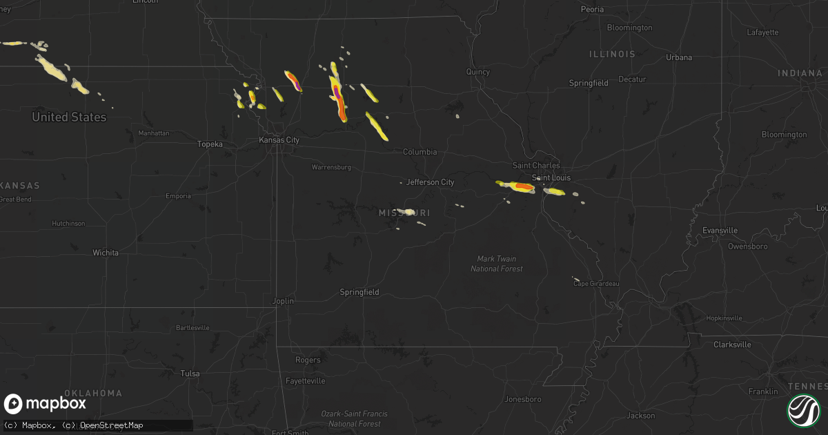
Hail Map in Missouri on May 14, 2019
Get this storm
May 14 map
$229
one time, instant access
Download today. No call, no setup
Keep the $229
Bought the map and want the full workflow? Apply the entire $229 to a subscription within 7 days. None of it is wasted.
Every map, not just this one
This buys you this map. Subscription and you get every map we run, in the markets you choose from a few cities to whole states to nationwide. Plus real-time alerts the moment a storm fires.
Contact data
Name, contact info, occupancy, even credit band for addresses in the footprint. You go from where it hit to who to call.
Become the source they trust
Unlimited branding weather history reports on demand. You already have the documented answer ready for the property owner, and you are the one who showed up with it.
Property data and RoofTrace estimates
Pull up any address you have got, its value and the exact code rules for that jurisdiction, straight from One Click Code. Then RoofTrace estimates the squares, pitch, and roof value, priced the way you price.
Storm reports in Missouri
Missouri
| Date | Description |
|---|---|
| 05/14/20191:00 PM CDT | Received via social media. |
| 05/14/20196:52 AM CDT | At 1151 PM CDT, a severe thunderstorm was located 7 miles east of Lake Ozark, or 7 miles northeast of Osage Beach, moving southeast at 35 mph. HAZARD...Quarter size hail. SOURCE...Radar indicated. IMPACT...Damage to vehicles is expected. Locations impacted include... Lake of The Ozarks State Park... Osage Beach... Lake Ozark... Crocker... Iberia... Saint Elizabeth... St. Elizabeth... Tuscumbia... Brumley... Ulman... |
| 05/14/20196:09 AM CDT | At 1109 PM CDT, a severe thunderstorm was located near Glasgow, moving southeast at 20 mph. HAZARD...60 mph wind gusts and half dollar size hail. SOURCE...Radar indicated. IMPACT...Hail damage to vehicles is expected. Expect wind damage to roofs, siding, and trees. Locations impacted include... New Franklin and Franklin. |
| 05/14/20195:40 AM CDT | At 1040 PM CDT, a severe thunderstorm was located near Slater, moving southeast at 20 mph. HAZARD...60 mph wind gusts and half dollar size hail. SOURCE...Radar indicated. IMPACT...Hail damage to vehicles is expected. Expect wind damage to roofs, siding, and trees. Locations impacted include... Gilliam. |
| 05/14/20195:21 AM CDT | At 1021 PM CDT, a severe thunderstorm was located near Slater, moving southeast at 20 mph. HAZARD...60 mph wind gusts and half dollar size hail. SOURCE...Radar indicated. IMPACT...Hail damage to vehicles is expected. Expect wind damage to roofs, siding, and trees. Locations impacted include... Slater, Glasgow and Gilliam. |
| 05/14/20194:58 AM CDT | At 958 PM CDT, a severe thunderstorm was located near Carrollton, moving south at 25 mph. HAZARD...Golf ball size hail and 60 mph wind gusts. SOURCE...Trained weather spotters. IMPACT...People and animals outdoors will be injured. Expect hail damage to roofs, siding, windows, and vehicles. Expect wind damage to roofs, siding, and trees. Locations impacted include... Carrollton and Bogard. |
| 05/14/20194:54 AM CDT | At 953 PM CDT, a severe thunderstorm was located over Brunswick, or 12 miles north of Slater, moving southeast at 15 mph. HAZARD...60 mph wind gusts and quarter size hail. SOURCE...Radar indicated. IMPACT...Hail damage to vehicles is expected. Expect wind damage to roofs, siding, and trees. Locations impacted include... Brunswick and Dalton. |
| 05/14/20194:38 AM CDT | At 938 PM CDT, a severe thunderstorm was located 11 miles east of Braymer, or 15 miles north of Carrollton, moving south at 20 mph. HAZARD...Golf ball size hail and 60 mph wind gusts. SOURCE...Trained weather spotters. IMPACT...People and animals outdoors will be injured. Expect hail damage to roofs, siding, windows, and vehicles. Expect wind damage to roofs, siding, and trees. Locations impacted include... Bosworth, Bogard and Tina. |
| 05/14/20194:19 AM CDT | At 919 PM CDT, a severe thunderstorm was located near Utica, or 10 miles south of Chillicothe, moving southeast at 25 mph. HAZARD...60 mph wind gusts and half dollar size hail. SOURCE...Radar indicated. IMPACT...Hail damage to vehicles is expected. Expect wind damage to roofs, siding, and trees. Locations impacted include... Utica, Tina, Ludlow and Dawn. |
| 05/14/20194:07 AM CDT | At 907 PM CDT, a severe thunderstorm was located 10 miles south of Marceline, moving southeast at 15 mph. HAZARD...60 mph wind gusts and quarter size hail. SOURCE...Radar indicated. IMPACT...Hail damage to vehicles is expected. Expect wind damage to roofs, siding, and trees. Locations impacted include... Rothville. |
| 05/14/20193:53 AM CDT | At 853 PM CDT, a severe thunderstorm was located near Utica, or near Chillicothe, moving southeast at 20 mph. HAZARD...60 mph wind gusts and half dollar size hail. SOURCE...Radar indicated. IMPACT...Hail damage to vehicles is expected. Expect wind damage to roofs, siding, and trees. Locations impacted include... Chillicothe, Utica, Mooresville, Dawn and Spring Hill. |
| 05/14/20193:44 AM CDT | At 844 PM CDT, a severe thunderstorm was located 8 miles southwest of Marceline, moving southeast at 15 mph. HAZARD...60 mph wind gusts and quarter size hail. SOURCE...Radar indicated. IMPACT...Hail damage to vehicles is expected. Expect wind damage to roofs, siding, and trees. Locations impacted include... Mendon and Rothville. |
| 05/14/20193:24 AM CDT | At 824 PM CDT, a severe thunderstorm was located over Plattsburg, moving southeast at 15 mph. HAZARD...60 mph wind gusts and quarter size hail. SOURCE...Radar indicated. IMPACT...Hail damage to vehicles is expected. Expect wind damage to roofs, siding, and trees. Locations impacted include... Plattsburg. |
| 05/14/20193:23 AM CDT | At 823 PM CDT, a severe thunderstorm was located 8 miles northwest of Chillicothe, moving southeast at 15 mph. HAZARD...60 mph wind gusts and quarter size hail. SOURCE...Radar indicated. IMPACT...Hail damage to vehicles is expected. Expect wind damage to roofs, siding, and trees. Locations impacted include... Chillicothe, Utica, Chula, Mooresville, Lock Springs and Spring Hill. |
| 05/14/20193:02 AM CDT | At 802 PM CDT, a severe thunderstorm was located near Gower, moving southeast at 15 mph. HAZARD...60 mph wind gusts and quarter size hail. SOURCE...Radar indicated. IMPACT...Hail damage to vehicles is expected. Expect wind damage to roofs, siding, and trees. Locations impacted include... Plattsburg and Gower. |
| 05/14/20193:00 AM CDT | At 800 PM CDT, a severe thunderstorm was located near Laclede, or near Brookfield, moving southeast at 20 mph. HAZARD...60 mph wind gusts and quarter size hail. SOURCE...Radar indicated. IMPACT...Hail damage to vehicles is expected. Expect wind damage to roofs, siding, and trees. Locations impacted include... Brookfield and Laclede. |
| 05/14/20192:58 AM CDT | At 758 PM CDT, a severe thunderstorm was located near Trenton, moving southeast at 20 mph. HAZARD...60 mph wind gusts and quarter size hail. SOURCE...Radar indicated. IMPACT...Hail damage to vehicles is expected. Expect wind damage to roofs, siding, and trees. Locations impacted include... Spring Hill. |
| 05/14/20192:55 AM CDT | At 755 PM CDT, a severe thunderstorm was located near Cameron, moving southeast at 20 mph. HAZARD...60 mph wind gusts and half dollar size hail. SOURCE...Radar indicated. IMPACT...Hail damage to vehicles is expected. Expect wind damage to roofs, siding, and trees. Locations impacted include... Cameron.This includes Interstate 35 in Missouri between mile markers 48 and58. |
| 05/14/20192:50 AM CDT | At 750 PM CDT, a severe thunderstorm was located near Rushville, or near Wathena, moving southeast at 15 mph. HAZARD...60 mph wind gusts and quarter size hail. SOURCE...Radar indicated. IMPACT...Hail damage to vehicles is expected. Expect wind damage to roofs, siding, and trees. Locations impacted include... Rushville. |
| 05/14/20192:49 AM CDT | At 749 PM CDT, a severe thunderstorm was located near Jamesport, or 8 miles north of Gallatin, moving southeast at 15 mph. HAZARD...60 mph wind gusts and quarter size hail. SOURCE...Radar indicated. IMPACT...Hail damage to vehicles is expected. Expect wind damage to roofs, siding, and trees. Locations impacted include... Jamesport. |
| 05/14/20192:36 AM CDT | At 736 PM CDT, a severe thunderstorm was located over Maysville, moving southeast at 15 mph. HAZARD...Golf ball size hail and 60 mph wind gusts. SOURCE...Emergency management. IMPACT...People and animals outdoors will be injured. Expect hail damage to roofs, siding, windows, and vehicles. Expect wind damage to roofs, siding, and trees. Locations impacted include... Maysville and Osborn. This includes Interstate 35 in Missouri near mile marker 62. |
| 05/14/20192:35 AM CDT | At 735 PM CDT, a severe thunderstorm was located near Stewartsville, or 7 miles north of Gower, moving southeast at 15 mph. HAZARD...60 mph wind gusts and quarter size hail. SOURCE...Radar indicated. IMPACT...Hail damage to vehicles is expected. Expect wind damage to roofs, siding, and trees. Locations impacted include... Gower and Easton. |
| 05/14/20192:15 AM CDT | At 715 PM CDT, a severe thunderstorm was located over Maysville, moving southeast at 20 mph. HAZARD...60 mph wind gusts and quarter size hail. SOURCE...Radar indicated. IMPACT...Hail damage to vehicles is expected. Expect wind damage to roofs, siding, and trees. Locations impacted include... Maysville, Weatherby and Amity. |
| 05/14/201912:29 AM CDT | Via mping. |
| 05/14/201912:25 AM CDT | Delayed report. Spotter reported 2-inch hail along starck lane. |
| 05/14/201912:22 AM CDT | Via twitter with picture. |
| 05/13/201910:43 PM CDT | A local report indicates 1.75 inch wind near 4 SE GILLIAM |
| 05/13/201910:14 PM CDT | Quarter size hail at the communications center in carrollton. |
| 05/13/20199:22 PM CDT | A local report indicates 1.25 inch wind near DEARBORN |
| 05/13/20199:20 PM CDT | Measured hail just under 2 inches. Time estimated from radar. |
| 05/13/20199:20 PM CDT | Corrects previous report from dawn. Public facebook report passed along via emergency management. Estimated to be golf ball or slightly larger. Report said that the sto |
| 05/13/20199:08 PM CDT | **delayed report** reported via mping. |
| 05/13/20199:03 PM CDT | Corrects location and time of previous hail report from 1 se mooresville. Measured 2.25 inches...from psu field project. |
| 05/13/20198:43 PM CDT | Mostly quarter sized hail... A few larger stones were noted according to son of storm spotter. |
| 05/13/20198:25 PM CDT | A local report indicates 1.00 inch wind near PLATTSBURG |
| 05/13/20198:13 PM CDT | Photo received via facebook. |
| 05/13/20198:05 PM CDT | A local report indicates 1.25 inch wind near 4 SW TRENTON |
| 05/13/20198:05 PM CDT | Large spike leading to measurement of 2.5 inches but core of hailstone closer to golf ball size. |
| 05/13/20198:02 PM CDT | A local report indicates 1.00 inch wind near CAMERON |
| 05/13/20198:00 PM CDT | Report via social media. |
| 05/13/20198:00 PM CDT | Report via social media. |
| 05/13/20197:58 PM CDT | Corrects time of previous hail report from 5 ne gower. Received via social media. |
| 05/13/20197:35 PM CDT | Corrects location and time of previous hail report from 2 nw cameron. Large spike leading to measurement of 2.5 inches but core of hailstone closer to golf ball size... |
| 05/13/20197:34 PM CDT | A local report indicates 1.75 inch wind near MAYSVILLE |
| 05/13/20197:33 PM CDT | Measured 1.52...from psu field project. |
All States Impacted by Hail Map on May 14, 2019
Cities Impacted by Hail Map on May 14, 2019
- Elk River, MN
- Anoka, MN
- Hill City, SD
- Alma, NE
- Holdrege, NE
- Chillicothe, MO
- Trenton, MO
- Jamesport, MO
- Dawn, MO
- Ludlow, MO
- Cameron, MO
- Osborn, MO
- Maysville, MO
- Mooresville, MO
- Utica, MO
- Bogard, MO
- Carrollton, MO
- Upland, NE
- Campbell, NE
- Eureka, MO
- Pacific, MO
- Labadie, MO
- Whitney, NE
- Harrison, NE
- Donna, TX
- Weslaco, TX
- Ashton, IA
- Sibley, IA
- Adrian, MN
- Rushmore, MN
- Roundup, MT
- Saint Albans, MO
- High Ridge, MO
- Gray Summit, MO
- Slater, MO
- Gilliam, MO
- Glasgow, MO
- Scandia, KS
- Rushville, MO
- Saint Joseph, MO
- Norway, KS
- Belleville, KS
- Courtland, KS
- Freeburg, IL
- Mascoutah, IL
- Andover, MN
- Cummings, KS
- Atchison, KS
- Sumner, MO
- Brookfield, MO
- Mendon, MO
- Rothville, MO
- Laclede, MO
- Lawrence, NE
- Blue Hill, NE
- Guide Rock, NE
- Bland, MO
- Belle, MO
- Lance Creek, WY
- Progreso, TX
- Mercedes, TX
- Alamo, TX
- San Juan, TX
- Perry, MO
- Santa Fe, MO
- Amity, MO
- Sundance, WY
- San Antonio, TX
- Edgemont, SD
- Belleville, IL
- East Carondelet, IL
- Saint Louis, MO
- Columbia, IL
- Millstadt, IL
- Wathena, KS
- De Kalb, MO
- Sheldon, IA
- Tuscumbia, MO
- Kaiser, MO
- Mankato, KS
- Webber, KS
- Burr Oak, KS
- Gower, MO
- Hildreth, NE
- Franklin, NE
- Meadville, MO
- Crawford, NE
- San Saba, TX
- Burfordville, MO
- Whitewater, MO
- Braymer, MO
- Weston, MO
- Dearborn, MO
- Western Grove, AR
- Saint Joe, AR
- Washington, MO
- Little Rock, IA
- Bladen, NE
- Gallatin, MO
- Jameson, MO
- Iberia, MO
- Crocker, MO
- Saint Clair, MO
- California, MO
- Orlando, FL
- Lenzburg, IL
- Sanborn, IA
- Archer, IA
- Polk City, FL
- Piedmont, SD
- Denton, KS
- Lancaster, KS
- Kerrville, TX
- Republic, KS
- Hardy, NE
- Mason, TX
- Brumley, MO
- Eldon, MO
- Ulman, MO
- Devils Tower, WY
- Tina, MO
- Ingram, TX
- Harper, TX
- Davenport, FL
- Chula, MO
- Spickard, MO
- Superior, NE
- Troy, KS
- Sturgis, SD
- Augusta, MO
- Ballwin, MO
- Marthasville, MO
- Villa Ridge, MO
- Wildwood, MO
- Fenton, MO
- House Springs, MO
- Woodstock, MN
- Easton, MO
- Stewartsville, MO
- Marble Hill, MO
- Galt, MO
- Mountain Home, TX
- Lismore, MN
- Franklin, MO
- Clyde, KS
- Clifton, KS
- Camdenton, MO
- Linn Creek, MO
- Red Cloud, NE
- Formoso, KS
- De Witt, MO
- Miami, MO
- Laddonia, MO
- Morganville, KS
- Salisbury, MO
- Wilcox, NE
- Platte City, MO
- Osage Beach, MO
- Rocky Mount, MO
- Lake Ozark, MO
- Agenda, KS
- Gravois Mills, MO
- Winchester, KS
- Hay Springs, NE
- Plattsburg, MO
- Brunswick, MO
- Dupo, IL
- Edinburg, TX
- Elsa, TX
- Pharr, TX
- Edcouch, TX


