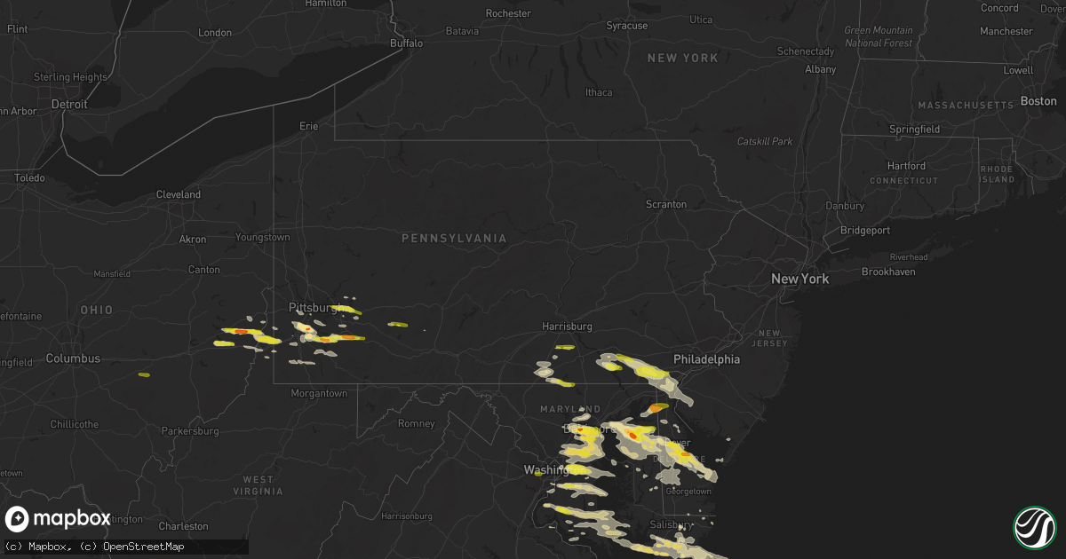
Hail Map in Pennsylvania on May 12, 2018
Get this storm
May 12 map
$229
one time, instant access
Download today. No call, no setup
Keep the $229
Bought the map and want the full workflow? Apply the entire $229 to a subscription within 7 days. None of it is wasted.
Every map, not just this one
This buys you this map. Subscription and you get every map we run, in the markets you choose from a few cities to whole states to nationwide. Plus real-time alerts the moment a storm fires.
Contact data
Name, contact info, occupancy, even credit band for addresses in the footprint. You go from where it hit to who to call.
Become the source they trust
Unlimited branding weather history reports on demand. You already have the documented answer ready for the property owner, and you are the one who showed up with it.
Property data and RoofTrace estimates
Pull up any address you have got, its value and the exact code rules for that jurisdiction, straight from One Click Code. Then RoofTrace estimates the squares, pitch, and roof value, priced the way you price.
Storm reports in Pennsylvania
Pennsylvania
| Date | Description |
|---|---|
| 05/12/20186:35 PM CDT | Mping report of quarter sized hail. |
| 05/12/20186:25 PM CDT | Trees and wires down |
| 05/12/20186:25 PM CDT | Photo of quarter sized hail in west grove. Time estimated from radar. |
| 05/12/20186:20 PM CDT | Wires down and tree hanging over roadway. Dairyland road |
| 05/12/20186:02 PM CDT | Trees and wires down on crawley road |
| 05/12/20185:55 PM CDT | Trees and wires down |
| 05/12/20185:40 PM CDT | Trees and wires down |
| 05/12/20184:50 PM CDT | Tree down along bridge street |
| 05/12/20184:43 PM CDT | Many trees down along barr rd and lutes rd |
| 05/12/20184:40 PM CDT | Large hail reported as part of downburst earlier noted along valley view road. |
| 05/12/20184:40 PM CDT | Trees down along bower hill rd at sienna trail |
| 05/12/20184:40 PM CDT | High-tension lines reported down along valley view rd. Widespread tree damage in this vicinity and along munntown rd associated with earlier-reported downburst. |
| 05/12/20184:40 PM CDT | Dozens of trees snapped or uprooted. Roof of barn and carport removed... Among other structural damage. Radar imagery at the time depicts clear downburst at this locati |
| 05/12/20183:45 PM CDT | A local report indicates 1.00 inch wind near SMITHTON |
| 05/12/20183:43 PM CDT | Trees and wires down |
| 05/12/20183:40 PM CDT | Trees down |
| 05/12/20183:37 PM CDT | A local report indicates 1.00 inch wind near PRICEDALE |
| 05/12/20183:35 PM CDT | Trees and wires down |
| 05/12/20183:32 PM CDT | A local report indicates 1.00 inch wind near MOUNT PLEASANT |
| 05/12/20183:30 PM CDT | A local report indicates 1.00 inch wind near PRICEDALE |
| 05/12/20183:29 PM CDT | Trees and wires down |
| 05/12/20183:29 PM CDT | A local report indicates 1.25 inch wind near CHARLEROI |
| 05/12/20183:22 PM CDT | Trees down along creek rd |
| 05/12/20183:18 PM CDT | A local report indicates 1.25 inch wind near WEST ALEXANDER |
| 05/12/20183:09 PM CDT | Several trees down around the city and outskirts... Including across railroad tracks. One large tree brought down power poles. |
| 05/12/20182:57 PM CDT | A local report indicates 1.00 inch wind near NEW ALEXANDRIA |
| 05/12/20182:50 PM CDT | Tree down on maplewood drive |
| 05/12/20182:50 PM CDT | A local report indicates 1.00 inch wind near DELMONT |
| 05/12/20182:43 PM CDT | A local report indicates 1.00 inch wind near MURRYSVILLE |
| 05/12/20182:30 PM CDT | Trees and wires down on killian street |
| 05/12/20182:25 PM CDT | Trees down at the intersection of friendship ave. And roup ave. |
| 05/12/20182:00 PM CDT | Tree down along latrobe-crabtree road |
| 05/12/20181:55 AM CDT | At 655 PM EDT, severe thunderstorms were located along a line extending from York Airport to near Gettysburg, moving east at 35 mph. HAZARD...60 mph wind gusts and quarter size hail. SOURCE...Radar indicated. IMPACT...Damaging winds will cause some trees and large branches to fall. This could injure those outdoors, as well as damage homes and vehicles. Roadways may become blocked by downed trees. Localized power outages are possible. Unsecured light objects may become projectiles. Locations impacted include... Cockeysville, Westminster, Bel Air South, Bel Air North, Carney, Perry Hall, Mays Chapel, Timonium, Fallston, Taneytown, Hampstead, Hampton, Manchester, Kingsville, Pleasant Hills, Jarrettsville, Lutherville-Timonium, Lutherville, Pylesville and Darlington. |
| 05/12/20181:53 AM CDT | At 653 PM EDT, a severe thunderstorm was located over Strasburg, moving east at 35 mph. HAZARD...60 mph wind gusts and quarter size hail. SOURCE...Radar indicated. IMPACT...Hail damage to vehicles is possible. Expect wind damage to trees and power lines. Locations impacted include... Millersville, Willow Street, Lancaster, Columbia, Quarryville, Mountville, Smithville, Strasburg, Gap and Safe Harbor. |
| 05/12/20181:21 AM CDT | At 621 PM EDT, a severe thunderstorm was located near Jerome, moving east at 50 mph. HAZARD...60 mph wind gusts and quarter size hail. SOURCE...Radar indicated. IMPACT...Hail damage to vehicles is possible. Expect wind damage to trees and power lines. Locations impacted include... Belmont, Johnstown, Westmont, Windber, Bedford, Acosta, Salix-Beauty Line Park, Osterburg, Central City and Cessna.This includes the following Interstates... The Pennsylvania Turnpike from mile markers 135 to 151. Interstate 99 from mile markers 0 to 14. |
| 05/12/20181:08 AM CDT | At 607 PM EDT, a severe thunderstorm was located near Dillsburg, moving east at 40 mph. Radar indicated rotation in this storm. Tornadoes sometimes occur with little or no warning. HAZARD...60 mph wind gusts and quarter size hail. SOURCE...Radar indicated. IMPACT...Hail damage to vehicles is possible. Expect wind damage to trees and power lines. Locations impacted include... Akron, Millersville, Mount Joy, Willow Street, Manheim, Columbia, Weigelstown, York, East Petersburg and Elizabethtown.This includes Interstate 83 from mile markers 15 to 34. |
| 05/12/201812:30 AM CDT | At 530 PM EDT, a severe thunderstorm was located over Upper St. Clair, or over Bethel Park, moving southeast at 45 mph. HAZARD...Wind gusts to 60 mph. SOURCE...Radar. IMPACT...Expect damage to trees and power lines, resulting in some power outages. Locations impacted include... Pittsburgh... Mount Lebanon... Bethel Park... McMurray... Greensburg... McKeesport... Jeannette... Canonsburg... Gastonville... West Mifflin... Baldwin... Upper St. Clair...This includes the following highways... Interstate 70 in Pennsylvania between mile markers 25 and 57. Pennsylvania Turnpike between mile markers 65 and 80. Interstate 79 in Pennsylvania between mile markers 22 and 25. |
| 05/11/201811:37 PM CDT | At 437 PM EDT, a severe thunderstorm was located near Monessen, or 12 miles southeast of Gastonville, moving east at 45 mph. HAZARD...Wind gusts to 60 mph and half dollar-size hail. SOURCE...Radar. IMPACT...Minor hail damage to vehicles is possible. Expect wind damage to trees and power lines, resulting in some power outages. Locations impacted include... Connellsville... Monessen... California... Donora... Mount Pleasant... Scottdale... West Newton... New Stanton... South Connellsville... Perryopolis... Seven Springs... North Belle Vernon...This includes the following highways... Interstate 70 in Pennsylvania between mile markers 41 and 54. Pennsylvania Turnpike between mile markers 78 and 99. |
| 05/11/201811:19 PM CDT | At 419 PM EDT, a severe thunderstorm was located near Ligonier, moving east at 45 mph. HAZARD...60 mph wind gusts and quarter size hail. SOURCE...Radar indicated. IMPACT...Expect wind damage to trees and power lines. Hail damage to vehicles is possible. Locations impacted include... Belmont, Johnstown, Westmont, Windber, Portage, Acosta, Salix-Beauty Line Park, Osterburg, Central City and Cessna.This includes the following Interstates... The Pennsylvania Turnpike from mile markers 134 to 145. Interstate 99 from mile markers 0 to 24. |
| 05/11/201811:16 PM CDT | At 415 PM EDT, a severe thunderstorm was located near West Newton, or 10 miles northwest of Connellsville, moving east at 35 mph. HAZARD...Wind gusts to 60 mph and half dollar-size hail. SOURCE...Radar. IMPACT...Minor hail damage to vehicles is possible. Expect wind damage to trees and power lines, resulting in some power outages. Locations impacted include... Connellsville... Mount Pleasant... Scottdale... Youngwood... West Newton... New Stanton... Perryopolis... Seven Springs... Calumet-Norvelt... Everson... Smithton... Madison...This includes the following highways... Interstate 70 in Pennsylvania between mile markers 46 and 57. Pennsylvania Turnpike between mile markers 75 and 99. |
| 05/11/201811:13 PM CDT | At 412 PM EDT, severe thunderstorms were located along a line extending from near Black Lick to near Derry to Latrobe, moving east at 35 mph. HAZARD...Wind gusts to 60 mph and half dollar-size hail. SOURCE...Public. IMPACT...Minor hail damage to vehicles is possible. Expect wind damage to trees and power lines, resulting in some power outages. Locations impacted include... Greensburg... Latrobe... Homer City... McChesneytown-Loyalhanna... Blairsville... Derry... Lawson Heights... Ligonier... Black Lick... New Florence... Seward... Bolivar... |
| 05/11/201811:12 PM CDT | At 411 PM EDT, a severe thunderstorm was located near New Enterprise, moving east at 50 mph. HAZARD...60 mph wind gusts and quarter size hail. SOURCE...Radar indicated. IMPACT...Hail damage to vehicles is possible. Expect wind damage to trees and power lines. Locations impacted include... Chambersburg, Waterfall, Dudley, New Enterprise, Harrisonville, Willow Hill, Entriken, Fannettsburg, Saluvia and Roxbury.This includes the following Interstates... The Pennsylvania Turnpike from mile markers 165 to 201. Interstate 81 from mile markers 14 to 15. |
| 05/11/201810:54 PM CDT | At 354 PM EDT, a severe thunderstorm was located near Tiltonsville, or near Clearview, moving east at 50 mph. HAZARD...Wind gusts to 60 mph and half dollar-size hail. SOURCE...Radar. IMPACT...Minor hail damage to vehicles is possible. Expect wind damage to trees and power lines, resulting in some power outages. Locations impacted include... Pittsburgh... Mount Lebanon... Bethel Park... McMurray... Washington... Canonsburg... Martins Ferry... Warwood... Wellsburg... West Liberty... Avella... Clearview...This includes the following highways... Interstate 70 in Pennsylvania between mile markers 0 and 39. Interstate 79 in Pennsylvania between mile markers 22 and 25. |
| 05/11/201810:29 PM CDT | At 329 PM EDT, a severe thunderstorm was located over Penn Hills, moving east at 45 mph. HAZARD...Wind gusts to 60 mph and half dollar-size hail. SOURCE...Radar. IMPACT...Minor hail damage to vehicles is possible. Expect wind damage to trees and power lines, resulting in some power outages. Locations impacted include... Pittsburgh... Penn Hills... Monroeville... Indiana... Vandergrift... Homer City... Apollo... Plum... West Mifflin... Murrysville... Wilkinsburg... New Kensington...This includes Pennsylvania Turnpike between mile markers 42 and 62. |
| 05/11/201810:23 PM CDT | At 323 PM EDT, a severe thunderstorm was located 8 miles west of Westmont, moving east at 40 mph. HAZARD...60 mph wind gusts and quarter size hail. SOURCE...Radar indicated. IMPACT...Hail damage to vehicles is possible. Expect wind damage to trees and power lines. Locations impacted include... Belmont, Johnstown, Westmont, Windber, Portage, Salix-Beauty Line Park, Osterburg, Roaring Spring, Scalp Level and Ski Gap.This includes Interstate 99 from mile markers 7 to 24. |
All States Impacted by Hail Map on May 12, 2018
Cities Impacted by Hail Map on May 12, 2018
- Plainfield, IL
- Dover, PA
- Wellsville, PA
- Church Hill, MD
- Galena, MD
- Kennedyville, MD
- Millington, MD
- Chestertown, MD
- Worton, MD
- Gunpowder, MD
- Middle River, MD
- Lusby, MD
- Chicago Heights, IL
- Olympia Fields, IL
- Park Forest, IL
- Matteson, IL
- Newburg, MD
- Chaptico, MD
- Bushwood, MD
- Seymour, IA
- Corydon, IA
- Allerton, IA
- La Plata, MD
- Indian Head, MD
- Marbury, MD
- Salisbury, MD
- Parsonsburg, MD
- Westminster, MD
- Manchester, MD
- Littlestown, PA
- Hanover, PA
- Diagonal, IA
- Chenoa, IL
- Canonsburg, PA
- Muse, PA
- Strabane, PA
- Finleyville, PA
- Eighty Four, PA
- Venetia, PA
- Hartly, DE
- Marydel, MD
- Crumpton, MD
- Marydel, DE
- Frederica, DE
- Sudlersville, MD
- Camden Wyoming, DE
- Milford, DE
- Dover, DE
- Barclay, MD
- Ingleside, MD
- Clayton, DE
- Viola, DE
- Woodside, DE
- Magnolia, DE
- Harrington, DE
- Henderson, MD
- Felton, DE
- Centreville, MD
- McDonald, PA
- Oakdale, PA
- Presto, PA
- Conestoga, PA
- Holtwood, PA
- Airville, PA
- Brogue, PA
- Pequea, PA
- Felton, PA
- Halethorpe, MD
- Brooklyn, MD
- Curtis Bay, MD
- Baltimore, MD
- Catonsville, MD
- Bentleyville, PA
- Monessen, PA
- Belle Vernon, PA
- Upper Marlboro, MD
- New Oxford, PA
- Gettysburg, PA
- Smithton, PA
- Ruffs Dale, PA
- Van Voorhis, PA
- Dawson, PA
- Alverton, PA
- Perryopolis, PA
- Dunlevy, PA
- Tarrs, PA
- Mount Pleasant, PA
- Wickhaven, PA
- Charleroi, PA
- Monongahela, PA
- Owings, MD
- Fort Washington, MD
- Dunkirk, MD
- Cheltenham, MD
- Clinton, MD
- Friendship, MD
- Brandywine, MD
- Lamoni, IA
- Warwick, MD
- Chesapeake City, MD
- Harwood, MD
- Hyattsville, MD
- Lanham, MD
- Davidsonville, MD
- Bowie, MD
- Pocomoke City, MD
- Deal Island, MD
- Lineville, IA
- Clio, IA
- Cordova, MD
- New Church, VA
- Horntown, VA
- Wallops Island, VA
- Monroeville, PA
- Delmont, PA
- Export, PA
- Murrysville, PA
- Greensburg, PA
- Pittsburgh, PA
- Westover, MD
- Girdletree, MD
- Snow Hill, MD
- Stockton, MD
- Princess Anne, MD
- Cape May, NJ
- Villas, NJ
- Kellerton, IA
- Blythedale, MO
- Mount Ayr, IA
- Grand River, IA
- Decatur, IA
- Davis City, IA
- Leon, IA
- Chesapeake Beach, MD
- North Beach, MD
- Cadiz, OH
- Rayland, OH
- Dillonvale, OH
- Adena, OH
- Oneill, NE
- Westbrook, TX
- Johnstown, PA
- Downers Grove, IL
- Bolingbrook, IL
- Darien, IL
- Woodridge, IL
- Naperville, IL
- Patuxent River, MD
- Tyaskin, MD
- Lexington Park, MD
- California, MD
- Hughesville, MD
- Newark, MD
- Crapo, MD
- Port Republic, MD
- Taylors Island, MD
- Quantico, MD
- Clements, MD
- Fishing Creek, MD
- Chincoteague Island, VA
- Church Creek, MD
- Leonardtown, MD
- Dowell, MD
- Broomes Island, MD
- Prince Frederick, MD
- Port Tobacco, MD
- Hollywood, MD
- Berlin, MD
- Saint Leonard, MD
- Bryantown, MD
- Solomons, MD
- Great Mills, MD
- Mechanicsville, MD
- Charlotte Hall, MD
- Marion Station, MD
- Loveville, MD
- Churchton, MD
- Shady Side, MD
- Stevensville, MD
- Lothian, MD
- Galesville, MD
- District Heights, MD
- West River, MD
- Capitol Heights, MD
- Edgewater, MD
- Towson, MD
- Pikesville, MD
- Lutherville Timonium, MD
- Moulton, IA
- Bridgeville, DE
- Frankford, DE
- Millsboro, DE
- Reisterstown, MD
- Cockeysville, MD
- Donaldsonville, LA
- Galva, IL
- Wheeling, WV
- Beltsville, MD
- Annapolis Junction, MD
- Glen Burnie, MD
- Severn, MD
- Severna Park, MD
- Laurel, MD
- Glenn Dale, MD
- Crofton, MD
- Ellicott City, MD
- Gambrills, MD
- Hanover, MD
- Woodstock, MD
- Fort Howard, MD
- Fort George G Meade, MD
- Dundalk, MD
- Pasadena, MD
- Odenton, MD
- Crownsville, MD
- Savage, MD
- Millersville, MD
- Sparrows Point, MD
- Greenbelt, MD
- Linthicum Heights, MD
- Annapolis, MD
- Burtonsville, MD
- Gwynn Oak, MD
- Elkridge, MD
- Gibson Island, MD
- Silver Spring, MD
- Windsor Mill, MD
- Arnold, MD
- Jessup, MD
- Avonmore, PA
- Willards, MD
- Valley Grove, WV
- West Liberty, WV
- Wellsburg, WV
- Yorkville, OH
- Windsor Heights, WV
- West Alexander, PA
- Martins Ferry, OH
- Claysville, PA
- Tiltonsville, OH
- Triadelphia, WV
- Abell, MD
- Avenue, MD
- Coltons Point, MD
- Alum Bank, PA
- Washington, PA
- Tracys Landing, MD
- Albia, IA
- Rock Hall, MD
- Beech Bottom, WV
- Freeport, OH
- Goldsboro, MD
- Lewes, DE
- Still Pond, MD
- Betterton, MD
- Massey, MD
- Greensboro, MD
- Milton, DE
- Queen Anne, MD
- Essex, MD
- Ridgely, MD
- Aberdeen Proving Ground, MD
- Dover Afb, DE
- West Grove, PA
- Lincoln University, PA
- Landenberg, PA
- Avondale, PA
- Oxford, PA
- Cochranville, PA
- Fayette City, PA
- Scottdale, PA
- Coal Center, PA
- Marriottsville, MD
- West Friendship, MD
- Snyder, TX
- Carmichaels, PA
- Jefferson, PA
- Waynesburg, PA
- Exline, IA
- Cincinnati, IA
- Centerville, IA
- Homewood, IL
- Tinley Park, IL
- Country Club Hills, IL
- Flossmoor, IL
- Mokena, IL
- Frankfort, IL
- Glen Rock, PA
- Glenville, PA
- Mount Rainier, MD
- Washington, DC
- Brentwood, MD
- Bladensburg, MD
- Bloomfield, IA
- Lancaster, PA
- Washington Boro, PA
- Millersville, PA
- New Castle, DE
- Willow Street, PA
- Atglen, PA
- Toughkenamon, PA
- Ronks, PA
- Coatesville, PA
- Kennett Square, PA
- Strasburg, PA
- Bear, DE
- Paradise, PA
- Yorklyn, DE
- Hockessin, DE
- New Providence, PA
- Christiana, PA
- Quarryville, PA
- Wilmington, DE
- Kirkwood, PA
- Newark, DE
- Bridgeton, NJ
- Salem, NJ
- Alloway, NJ
- Woodstown, NJ
- Mingo Junction, OH
- Farmington, IA
- Donnellson, IA
- Alexandria, VA
- Earleville, MD
- Middletown, DE
- Biglerville, PA
- Pennsville, NJ
- Apollo, PA
- West Finley, PA
- Smyrna, DE
- Federalsburg, MD
- Hurlock, MD
- Linwood, KS
- Tonganoxie, KS
- Bethel Park, PA
- Yorkville, IL
- King George, VA
- Dahlgren, VA
- Queenstown, MD
- Cainsville, MO
- New Stanton, PA
- Irwin, PA
- Darragh, PA
- Herminie, PA
- Arona, PA
- Denton, MD
- Easton, MD
- Altona, IL
- Donora, PA
- Luxor, PA
- Hannastown, PA
- Crabtree, PA
- Latrobe, PA
- Tingley, IA
- Sunderland, MD
- Coats, NC
- Bel Alton, MD
- Bridgeville, PA
- South Park, PA
- Houston, PA
- New Market, IA
- Gravity, IA
- Bedford, IA
- Huntingtown, MD
- Barnesville, OH
- Piedmont, OH
- Flushing, OH
- Ocean City, MD
- Red Lion, PA
- Windsor, PA
- Elkton, MD
- Chadds Ford, PA
- Parkesburg, PA
- Wrightsville, PA
- East Berlin, PA
- Aspers, PA
- Wellington, TX
- Blackfoot, ID
- Lone Tree, IA
- Clarendon, TX
- Bishopville, MD
- Bryans Road, MD
- Fort Belvoir, VA
- Accokeek, MD
- Woodbine, NJ
- Houston, DE
- Ellendale, DE
- Lincoln, DE
- Greenwood, DE
- Dallas, WV
- Moundsville, WV
- Elizabeth, PA
- Clairton, PA
- West Elizabeth, PA
- Avella, PA
- Russell, IA
- Chariton, IA
- Quaker City, OH
- Bethesda, OH
- Belmont, OH
- Harrison City, PA
- Jeannette, PA
- Weldon, IA
- Van Wert, IA
- Dillsburg, PA
- Selbyville, DE
- Arbela, MO
- Memphis, MO
- Bellaire, OH
- Benwood, WV
- Saint Clairsville, OH
- Bridgeport, OH
- Randallstown, MD
- Owings Mills, MD
- Stevenson, MD
- Boswell, PA
- Mount Sterling, IA
- Amity, PA
- Prosperity, PA
- Blockton, IA
- Benton, IA
- Milton, IA
- Cantril, IA
- Townsend, DE
- Denbo, PA
- Vanderbilt, PA
- La Belle, PA
- Brownsville, PA
- Dunbar, PA
- Smock, PA
- Fredericktown, PA
- Hiller, PA
- Daisytown, PA
- Grindstone, PA
- New Salem, PA
- Vestaburg, PA
- Waltersburg, PA
- Clarksville, PA
- East Millsboro, PA
- Sycamore, PA
- Lancaster, MO
- Woodhull, IL
- La Fayette, IL
- Chester, MD
- Acme, PA
- Scenery Hill, PA
- Hickory, PA
- West Newton, PA
- Bloomingdale, OH
- Davidsville, PA
- New Alexandria, PA
- Bethany, WV
- Somerset, OH
- Roseville, OH
- New Lexington, OH
- Crooksville, OH
- Drumore, PA
- Lewisberry, PA
- York, PA
- Falls Church, VA
- Fairfax, VA
- Annandale, VA


