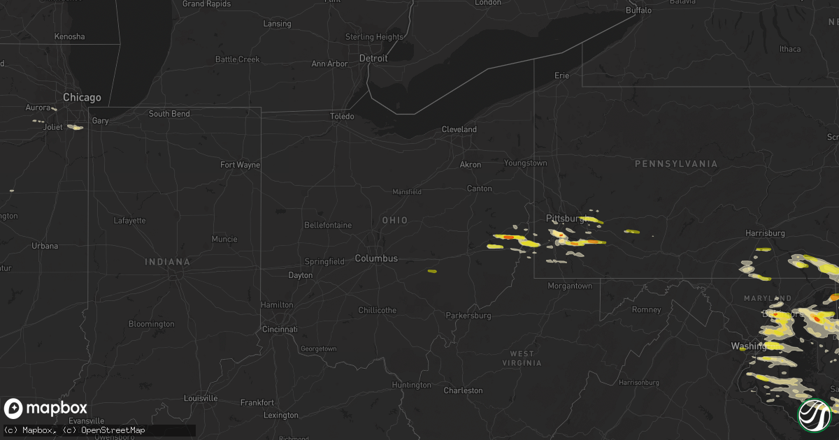
Hail Map in Ohio on May 12, 2018
Get this storm
May 12 map
$229
one time, instant access
Download today. No call, no setup
Keep the $229
Bought the map and want the full workflow? Apply the entire $229 to a subscription within 7 days. None of it is wasted.
Every map, not just this one
This buys you this map. Subscription and you get every map we run, in the markets you choose from a few cities to whole states to nationwide. Plus real-time alerts the moment a storm fires.
Contact data
Name, contact info, occupancy, even credit band for addresses in the footprint. You go from where it hit to who to call.
Become the source they trust
Unlimited branding weather history reports on demand. You already have the documented answer ready for the property owner, and you are the one who showed up with it.
Property data and RoofTrace estimates
Pull up any address you have got, its value and the exact code rules for that jurisdiction, straight from One Click Code. Then RoofTrace estimates the squares, pitch, and roof value, priced the way you price.
Storm reports in Ohio
Ohio
| Date | Description |
|---|---|
| 05/12/20183:58 PM CDT | A local report indicates 1.00 inch wind near 1 SSW ROSEVILLE |
| 05/12/20183:39 PM CDT | A tree and a powerline were reported downed in summerford |
| 05/12/20182:44 PM CDT | A local report indicates 1.50 inch wind near ADENA |
| 05/11/201811:53 PM CDT | At 453 PM EDT, a severe thunderstorm was located near Perry State Forest, moving east at 45 mph. HAZARD...60 mph wind gusts and quarter size hail. SOURCE...Radar indicated. IMPACT...Hail damage to vehicles is expected. Expect wind damage to roofs, siding, and trees. Locations impacted include... Crooksville. |
| 05/11/201811:42 PM CDT | At 442 PM EDT, a severe thunderstorm was located over London, moving east at 30 mph. HAZARD...60 mph wind gusts and quarter size hail. SOURCE...Radar indicated. IMPACT...Minor hail damage to vehicles is possible. Expect wind damage to trees and power lines. Locations impacted include... Columbus, Grove City, London, Jefferson, West Jefferson, South Bloomfield, Choctaw Lake, Lake Darby, Grandview Heights, Obetz, Commercial Point, Urbancrest, Valleyview, Marble Cliff, Lafayette, Harrisburg, Orient, Lockbourne, Newport and Georgesville.This includes the following Interstates... I-70 in Ohio between mile markers 73 and 102. I-71 in Ohio between mile markers 86 and 109. |
All States Impacted by Hail Map on May 12, 2018
Cities Impacted by Hail Map on May 12, 2018
- Plainfield, IL
- Dover, PA
- Wellsville, PA
- Church Hill, MD
- Galena, MD
- Kennedyville, MD
- Millington, MD
- Chestertown, MD
- Worton, MD
- Gunpowder, MD
- Middle River, MD
- Lusby, MD
- Chicago Heights, IL
- Olympia Fields, IL
- Park Forest, IL
- Matteson, IL
- Newburg, MD
- Chaptico, MD
- Bushwood, MD
- Seymour, IA
- Corydon, IA
- Allerton, IA
- La Plata, MD
- Indian Head, MD
- Marbury, MD
- Salisbury, MD
- Parsonsburg, MD
- Westminster, MD
- Manchester, MD
- Littlestown, PA
- Hanover, PA
- Diagonal, IA
- Chenoa, IL
- Canonsburg, PA
- Muse, PA
- Strabane, PA
- Finleyville, PA
- Eighty Four, PA
- Venetia, PA
- Hartly, DE
- Marydel, MD
- Crumpton, MD
- Marydel, DE
- Frederica, DE
- Sudlersville, MD
- Camden Wyoming, DE
- Milford, DE
- Dover, DE
- Barclay, MD
- Ingleside, MD
- Clayton, DE
- Viola, DE
- Woodside, DE
- Magnolia, DE
- Harrington, DE
- Henderson, MD
- Felton, DE
- Centreville, MD
- McDonald, PA
- Oakdale, PA
- Presto, PA
- Conestoga, PA
- Holtwood, PA
- Airville, PA
- Brogue, PA
- Pequea, PA
- Felton, PA
- Halethorpe, MD
- Brooklyn, MD
- Curtis Bay, MD
- Baltimore, MD
- Catonsville, MD
- Bentleyville, PA
- Monessen, PA
- Belle Vernon, PA
- Upper Marlboro, MD
- New Oxford, PA
- Gettysburg, PA
- Smithton, PA
- Ruffs Dale, PA
- Van Voorhis, PA
- Dawson, PA
- Alverton, PA
- Perryopolis, PA
- Dunlevy, PA
- Tarrs, PA
- Mount Pleasant, PA
- Wickhaven, PA
- Charleroi, PA
- Monongahela, PA
- Owings, MD
- Fort Washington, MD
- Dunkirk, MD
- Cheltenham, MD
- Clinton, MD
- Friendship, MD
- Brandywine, MD
- Lamoni, IA
- Warwick, MD
- Chesapeake City, MD
- Harwood, MD
- Hyattsville, MD
- Lanham, MD
- Davidsonville, MD
- Bowie, MD
- Pocomoke City, MD
- Deal Island, MD
- Lineville, IA
- Clio, IA
- Cordova, MD
- New Church, VA
- Horntown, VA
- Wallops Island, VA
- Monroeville, PA
- Delmont, PA
- Export, PA
- Murrysville, PA
- Greensburg, PA
- Pittsburgh, PA
- Westover, MD
- Girdletree, MD
- Snow Hill, MD
- Stockton, MD
- Princess Anne, MD
- Cape May, NJ
- Villas, NJ
- Kellerton, IA
- Blythedale, MO
- Mount Ayr, IA
- Grand River, IA
- Decatur, IA
- Davis City, IA
- Leon, IA
- Chesapeake Beach, MD
- North Beach, MD
- Cadiz, OH
- Rayland, OH
- Dillonvale, OH
- Adena, OH
- Oneill, NE
- Westbrook, TX
- Johnstown, PA
- Downers Grove, IL
- Bolingbrook, IL
- Darien, IL
- Woodridge, IL
- Naperville, IL
- Patuxent River, MD
- Tyaskin, MD
- Lexington Park, MD
- California, MD
- Hughesville, MD
- Newark, MD
- Crapo, MD
- Port Republic, MD
- Taylors Island, MD
- Quantico, MD
- Clements, MD
- Fishing Creek, MD
- Chincoteague Island, VA
- Church Creek, MD
- Leonardtown, MD
- Dowell, MD
- Broomes Island, MD
- Prince Frederick, MD
- Port Tobacco, MD
- Hollywood, MD
- Berlin, MD
- Saint Leonard, MD
- Bryantown, MD
- Solomons, MD
- Great Mills, MD
- Mechanicsville, MD
- Charlotte Hall, MD
- Marion Station, MD
- Loveville, MD
- Churchton, MD
- Shady Side, MD
- Stevensville, MD
- Lothian, MD
- Galesville, MD
- District Heights, MD
- West River, MD
- Capitol Heights, MD
- Edgewater, MD
- Towson, MD
- Pikesville, MD
- Lutherville Timonium, MD
- Moulton, IA
- Bridgeville, DE
- Frankford, DE
- Millsboro, DE
- Reisterstown, MD
- Cockeysville, MD
- Donaldsonville, LA
- Galva, IL
- Wheeling, WV
- Beltsville, MD
- Annapolis Junction, MD
- Glen Burnie, MD
- Severn, MD
- Severna Park, MD
- Laurel, MD
- Glenn Dale, MD
- Crofton, MD
- Ellicott City, MD
- Gambrills, MD
- Hanover, MD
- Woodstock, MD
- Fort Howard, MD
- Fort George G Meade, MD
- Dundalk, MD
- Pasadena, MD
- Odenton, MD
- Crownsville, MD
- Savage, MD
- Millersville, MD
- Sparrows Point, MD
- Greenbelt, MD
- Linthicum Heights, MD
- Annapolis, MD
- Burtonsville, MD
- Gwynn Oak, MD
- Elkridge, MD
- Gibson Island, MD
- Silver Spring, MD
- Windsor Mill, MD
- Arnold, MD
- Jessup, MD
- Avonmore, PA
- Willards, MD
- Valley Grove, WV
- West Liberty, WV
- Wellsburg, WV
- Yorkville, OH
- Windsor Heights, WV
- West Alexander, PA
- Martins Ferry, OH
- Claysville, PA
- Tiltonsville, OH
- Triadelphia, WV
- Abell, MD
- Avenue, MD
- Coltons Point, MD
- Alum Bank, PA
- Washington, PA
- Tracys Landing, MD
- Albia, IA
- Rock Hall, MD
- Beech Bottom, WV
- Freeport, OH
- Goldsboro, MD
- Lewes, DE
- Still Pond, MD
- Betterton, MD
- Massey, MD
- Greensboro, MD
- Milton, DE
- Queen Anne, MD
- Essex, MD
- Ridgely, MD
- Aberdeen Proving Ground, MD
- Dover Afb, DE
- West Grove, PA
- Lincoln University, PA
- Landenberg, PA
- Avondale, PA
- Oxford, PA
- Cochranville, PA
- Fayette City, PA
- Scottdale, PA
- Coal Center, PA
- Marriottsville, MD
- West Friendship, MD
- Snyder, TX
- Carmichaels, PA
- Jefferson, PA
- Waynesburg, PA
- Exline, IA
- Cincinnati, IA
- Centerville, IA
- Homewood, IL
- Tinley Park, IL
- Country Club Hills, IL
- Flossmoor, IL
- Mokena, IL
- Frankfort, IL
- Glen Rock, PA
- Glenville, PA
- Mount Rainier, MD
- Washington, DC
- Brentwood, MD
- Bladensburg, MD
- Bloomfield, IA
- Lancaster, PA
- Washington Boro, PA
- Millersville, PA
- New Castle, DE
- Willow Street, PA
- Atglen, PA
- Toughkenamon, PA
- Ronks, PA
- Coatesville, PA
- Kennett Square, PA
- Strasburg, PA
- Bear, DE
- Paradise, PA
- Yorklyn, DE
- Hockessin, DE
- New Providence, PA
- Christiana, PA
- Quarryville, PA
- Wilmington, DE
- Kirkwood, PA
- Newark, DE
- Bridgeton, NJ
- Salem, NJ
- Alloway, NJ
- Woodstown, NJ
- Mingo Junction, OH
- Farmington, IA
- Donnellson, IA
- Alexandria, VA
- Earleville, MD
- Middletown, DE
- Biglerville, PA
- Pennsville, NJ
- Apollo, PA
- West Finley, PA
- Smyrna, DE
- Federalsburg, MD
- Hurlock, MD
- Linwood, KS
- Tonganoxie, KS
- Bethel Park, PA
- Yorkville, IL
- King George, VA
- Dahlgren, VA
- Queenstown, MD
- Cainsville, MO
- New Stanton, PA
- Irwin, PA
- Darragh, PA
- Herminie, PA
- Arona, PA
- Denton, MD
- Easton, MD
- Altona, IL
- Donora, PA
- Luxor, PA
- Hannastown, PA
- Crabtree, PA
- Latrobe, PA
- Tingley, IA
- Sunderland, MD
- Coats, NC
- Bel Alton, MD
- Bridgeville, PA
- South Park, PA
- Houston, PA
- New Market, IA
- Gravity, IA
- Bedford, IA
- Huntingtown, MD
- Barnesville, OH
- Piedmont, OH
- Flushing, OH
- Ocean City, MD
- Red Lion, PA
- Windsor, PA
- Elkton, MD
- Chadds Ford, PA
- Parkesburg, PA
- Wrightsville, PA
- East Berlin, PA
- Aspers, PA
- Wellington, TX
- Blackfoot, ID
- Lone Tree, IA
- Clarendon, TX
- Bishopville, MD
- Bryans Road, MD
- Fort Belvoir, VA
- Accokeek, MD
- Woodbine, NJ
- Houston, DE
- Ellendale, DE
- Lincoln, DE
- Greenwood, DE
- Dallas, WV
- Moundsville, WV
- Elizabeth, PA
- Clairton, PA
- West Elizabeth, PA
- Avella, PA
- Russell, IA
- Chariton, IA
- Quaker City, OH
- Bethesda, OH
- Belmont, OH
- Harrison City, PA
- Jeannette, PA
- Weldon, IA
- Van Wert, IA
- Dillsburg, PA
- Selbyville, DE
- Arbela, MO
- Memphis, MO
- Bellaire, OH
- Benwood, WV
- Saint Clairsville, OH
- Bridgeport, OH
- Randallstown, MD
- Owings Mills, MD
- Stevenson, MD
- Boswell, PA
- Mount Sterling, IA
- Amity, PA
- Prosperity, PA
- Blockton, IA
- Benton, IA
- Milton, IA
- Cantril, IA
- Townsend, DE
- Denbo, PA
- Vanderbilt, PA
- La Belle, PA
- Brownsville, PA
- Dunbar, PA
- Smock, PA
- Fredericktown, PA
- Hiller, PA
- Daisytown, PA
- Grindstone, PA
- New Salem, PA
- Vestaburg, PA
- Waltersburg, PA
- Clarksville, PA
- East Millsboro, PA
- Sycamore, PA
- Lancaster, MO
- Woodhull, IL
- La Fayette, IL
- Chester, MD
- Acme, PA
- Scenery Hill, PA
- Hickory, PA
- West Newton, PA
- Bloomingdale, OH
- Davidsville, PA
- New Alexandria, PA
- Bethany, WV
- Somerset, OH
- Roseville, OH
- New Lexington, OH
- Crooksville, OH
- Drumore, PA
- Lewisberry, PA
- York, PA
- Falls Church, VA
- Fairfax, VA
- Annandale, VA


