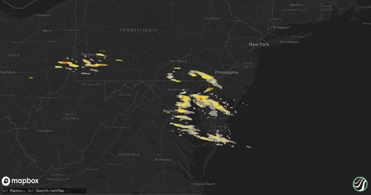
Hail Map on May 12, 2018
Get this storm
May 12 map
$229
one time, instant access
Download today. No call, no setup
Keep the $229
Bought the map and want the full workflow? Apply the entire $229 to a subscription within 7 days. None of it is wasted.
Every map, not just this one
This buys you this map. Subscription and you get every map we run, in the markets you choose from a few cities to whole states to nationwide. Plus real-time alerts the moment a storm fires.
Contact data
Name, contact info, occupancy, even credit band for addresses in the footprint. You go from where it hit to who to call.
Become the source they trust
Unlimited branding weather history reports on demand. You already have the documented answer ready for the property owner, and you are the one who showed up with it.
Property data and RoofTrace estimates
Pull up any address you have got, its value and the exact code rules for that jurisdiction, straight from One Click Code. Then RoofTrace estimates the squares, pitch, and roof value, priced the way you price.
States Impacted by Hail Map on May 12, 2018
Storm reports
Delaware
| Date | Description |
|---|---|
| 05/12/20186:36 PM CDT | A local report indicates 1.00 inch wind near HOCKESSIN |
| 05/12/20184:27 AM CDT | At 926 PM EDT, severe thunderstorms were located along a line extending from near Smithville to Talbot, moving east at 45 mph. HAZARD...60 mph wind gusts and quarter size hail. SOURCE...Radar indicated. IMPACT...Minor damage to vehicles is possible. Wind damage to roofs, siding, trees, and power lines is possible. Locations impacted include... Easton, Georgetown, Talbot, Milford, Seaford, Denton, Millsboro, Laurel, Harrington, Romancoke, Lewes, Federalsburg, Milton, Bridgeville, Trappe, St. Michaels, Dagsboro, Preston, Sharptown and Millville. |
| 05/12/20184:16 AM CDT | At 915 PM EDT, severe thunderstorms were located along a line extending from near Deale to near St. Michaels to Matthews to Ridgely, moving southeast at 35 mph. HAZARD...60 mph wind gusts and quarter size hail. SOURCE...Radar indicated. IMPACT...Minor damage to vehicles is possible. Expect wind damage to trees and powerlines. Severe thunderstorms will be near, Federalsburg around 935 PM EDT. Secretary around 945 PM EDT. Hurlock around 950 PM EDT. University Of Maryland Center For Environmental Studies around 955 PM EDT. Cambridge and Vienna around 1000 PM EDT. Sharptown around 1005 PM EDT. Delmar and Hebron around 1015 PM EDT. Other locations impacted by these severe thunderstorms includeGalestown, Catchpenny, Madison, Brookview, Eldorado, Royal Oak,Hudson, Church Creek, Lloyds and Mardela Springs. |
| 05/12/20183:51 AM CDT | At 851 PM EDT, severe thunderstorms were located along a line extending from Dover Base Housing to Centreville, moving east at 40 mph. HAZARD...60 mph wind gusts and quarter size hail. SOURCE...Radar indicated. IMPACT...Minor damage to vehicles is possible. Wind damage to roofs, siding, trees, and power lines is possible. Locations impacted include... Dover, Centerville, Milford, Denton, Centreville, Harrington, Camden, Greensboro, Oakland, Ridgely, Church Hill, Sudlersville, Bowers, Goldsboro, Woodside, Viola, Hartly, Old Town, Rising Sun-Lebanon and Starr. |
| 05/12/20183:40 AM CDT | At 840 PM EDT, severe thunderstorms were located along a line extending from near Overton to near Arnold to near Bowie, moving east at 45 mph. HAZARD...60 mph wind gusts and quarter size hail. SOURCE...Radar indicated. IMPACT...Minor damage to vehicles is possible. Wind damage to roofs, siding, trees, and power lines is possible. Locations impacted include... Easton, Talbot, Denton, Centreville, Greensboro, Oakland, Ridgely, Trappe, St. Michaels, Preston, Queen Anne, Grasonville, Starr, Copperville, Jumptown, Agner, Choptank, Windyhill, Tanyard and Harmony. |
| 05/12/20183:11 AM CDT | At 811 PM EDT, severe thunderstorms were located along a line extending from near Millington to near Dundalk, moving east at 35 mph. HAZARD...Two inch hail and 60 mph wind gusts. SOURCE...Radar indicated. IMPACT...People and animals outdoors will be injured. Expect hail damage to roofs, siding, windows, and vehicles. Wind damage to roofs, siding, trees, and power lines is possible. Locations impacted include... Dover, Centerville, Smyrna, Chestertown, Centreville, Camden, Clayton, Cheswold, Rock Hall, Church Hill, Millington, Sudlersville, Betterton, Goldsboro, Woodside, Hartly, Old Town, Hazlettville, Morgnec and Delaney Corner. |
| 05/12/20182:25 AM CDT | At 724 PM EDT, a severe thunderstorm was located over Newtown, or 11 miles south of Aberdeen Proving Ground, moving east at 40 mph. HAZARD...60 mph wind gusts and quarter size hail. SOURCE...Radar indicated. IMPACT...Minor damage to vehicles is possible. Wind damage to roofs, siding, trees, and power lines is possible. Locations impacted include... Smyrna, Chestertown, Clayton, Church Hill, Cecilton, Millington, Sudlersville, Betterton, Hartly, Warwick, Newtown, Morgnec, Delaney Corner, Crumpton, Sassafras, Green Spring, Langford, Massey, Kennedyville and Townsend. |
| 05/11/20187:58 PM CDT | Time approximated from radar. |
| 05/11/20187:56 PM CDT | A local report indicates 1.50 inch wind near 1 NNE WHITE HOUSE LANDI |
| 05/11/20187:56 PM CDT | Time approximated from radar. |
| 05/11/20187:52 PM CDT | Downed electrical pole and wires from strong thunderstorm winds. |
| 05/11/20187:52 PM CDT | Photo of quarter sized hail in highland acres. Time approximated from radar. |
| 05/11/20187:47 PM CDT | A local report indicates 1.25 inch wind near WYOMING |
| 05/11/20187:46 PM CDT | Trees and wires down in camden. Time approximated from radar. |
District of Columbia
| Date | Description |
|---|---|
| 05/12/20183:28 AM CDT | At 827 PM EDT, severe thunderstorms were located along a line extending from Fort Smallwood State Park to near Goddard, moving east at 35 mph. HAZARD...60 mph wind gusts and quarter size hail. SOURCE...Radar indicated. IMPACT...Damaging winds will cause some trees and large branches to fall. This could injure those outdoors, as well as damage homes and vehicles. Roadways may become blocked by downed trees. Localized power outages are possible. Unsecured light objects may become projectiles. Locations impacted include... Bowie, Severn, Annapolis, College Park, Crofton, Greenbelt, Forestville, Largo, Bladensburg, Mayo, Shady Side, Chesapeake Beach, Deale, Naval Academy, Upper Marlboro, Severn River, South River, Breezy Point, Fedex Field and Rhode River. |
| 05/12/20182:46 AM CDT | At 746 PM EDT, a severe thunderstorm was located over Mantua, moving east at 35 mph. HAZARD...60 mph wind gusts and quarter size hail. SOURCE...Radar indicated. IMPACT...Damaging winds will cause some trees and large branches to fall. This could injure those outdoors, as well as damage homes and vehicles. Roadways may become blocked by downed trees. Localized power outages are possible. Unsecured light objects may become projectiles. Locations impacted include... Arlington, Alexandria, Annandale, Clinton, Springfield, Fort Washington, Fairfax, Vienna, Groveton, Forestville, Falls Church, Huntington, Largo, Coral Hills, Bladensburg, Mantua, National Harbor, Nationals Park, Fedex Field and Howard University. |
North Carolina
| Date | Description |
|---|---|
| 05/12/20181:55 AM CDT | At 654 PM EDT, a slow moving severe thunderstorm was located near Hoffman, or 14 miles east of Rockingham, moving northeast at 5 mph. HAZARD...60 mph wind gusts and nickel size hail. SOURCE...Radar indicated. IMPACT...Expect damage to roofs, siding, and trees. Locations impacted include... Aberdeen, Hoffman, Pinebluff, Sandhills Game Land and Camp Mackall. |
Ohio
| Date | Description |
|---|---|
| 05/12/20183:58 PM CDT | A local report indicates 1.00 inch wind near 1 SSW ROSEVILLE |
| 05/12/20183:39 PM CDT | A tree and a powerline were reported downed in summerford |
| 05/12/20182:44 PM CDT | A local report indicates 1.50 inch wind near ADENA |
| 05/11/201811:53 PM CDT | At 453 PM EDT, a severe thunderstorm was located near Perry State Forest, moving east at 45 mph. HAZARD...60 mph wind gusts and quarter size hail. SOURCE...Radar indicated. IMPACT...Hail damage to vehicles is expected. Expect wind damage to roofs, siding, and trees. Locations impacted include... Crooksville. |
| 05/11/201811:42 PM CDT | At 442 PM EDT, a severe thunderstorm was located over London, moving east at 30 mph. HAZARD...60 mph wind gusts and quarter size hail. SOURCE...Radar indicated. IMPACT...Minor hail damage to vehicles is possible. Expect wind damage to trees and power lines. Locations impacted include... Columbus, Grove City, London, Jefferson, West Jefferson, South Bloomfield, Choctaw Lake, Lake Darby, Grandview Heights, Obetz, Commercial Point, Urbancrest, Valleyview, Marble Cliff, Lafayette, Harrisburg, Orient, Lockbourne, Newport and Georgesville.This includes the following Interstates... I-70 in Ohio between mile markers 73 and 102. I-71 in Ohio between mile markers 86 and 109. |
Illinois
| Date | Description |
|---|---|
| 05/12/20185:59 AM CDT | At 1058 PM CDT, a severe thunderstorm was located over Galva, or 8 miles southwest of Kewanee, moving east at 25 mph. HAZARD...Quarter size hail. SOURCE...Radar indicated. IMPACT...Damage to vehicles is expected. Locations impacted include... Toulon, Elmira and La Fayette. |
| 05/12/20185:53 AM CDT | At 1053 PM CDT, a severe thunderstorm was located over Galva, or 7 miles southwest of Kewanee, moving east at 30 mph. HAZARD...Quarter size hail. SOURCE...Radar indicated. IMPACT...Damage to vehicles is expected. Locations impacted include... Kewanee, Galva, Bishop Hill and Kewanee Municipal Airport. |
Georgia
| Date | Description |
|---|---|
| 05/12/20182:38 PM CDT | Roof damage to mobile home on browning rd. |
| 05/11/201811:30 PM CDT | At 430 PM EDT, a severe thunderstorm was located near Fort Gordon, and is nearly stationary. HAZARD...60 mph wind gusts and penny size hail. SOURCE...Radar indicated. IMPACT...Expect damage to roofs, siding, and trees. Locations impacted include... Grovetown, Evans, Augusta, Martinez and Fort Gordon. This includes the following highways... Interstate 20 in Georgia between mile markers 189 and 200. Interstate 520 in Georgia between mile markers 1 and 13. |
Maryland
| Date | Description |
|---|---|
| 05/12/20186:50 PM CDT | Photo of quarter sized hail at canal view estates in chesapeake city. Time approximated from radar. |
| 05/12/20186:33 PM CDT | Received call from trained spotter. Reported quarter sized hail near hanover... Pa/mason dixon line. |
| 05/12/20183:02 AM CDT | At 802 PM EDT, a severe thunderstorm was located over Elkridge, moving east at 25 mph. HAZARD...60 mph wind gusts and quarter to golf ball size hail. SOURCE...Radar indicated. IMPACT...Damaging winds will cause some trees and large branches to fall. This could injure those outdoors, as well as damage homes and vehicles. Roadways may become blocked by downed trees. Localized power outages are possible. Unsecured light objects may become projectiles. Locations impacted include... Baltimore, Severn, Elkridge, Riviera Beach, Baltimore-Washington Airport, Fort Smallwood State Park, Pinehurst, Gibson Island, Bodkin Point, Sillery Bay, Glen Burnie, Severna Park, Odenton, Pasadena, Arnold, Lake Shore, Ferndale, Brooklyn Park, Fort Meade and Green Haven. |
| 05/12/20182:45 AM CDT | At 744 PM EDT, severe thunderstorms were located along a line extending from Broomall to Wilmington to Brantwood, moving southeast at 40 mph. HAZARD...60 mph wind gusts and quarter size hail. SOURCE...Trained weather spotters. IMPACT...Minor damage to vehicles is possible. Wind damage to roofs, siding, trees, and power lines is possible. Locations impacted include... Wilmington, Vineland, Millville, Bridgeton, Middletown, Elkton, Cumberland, Chester, Deptford, West Deptford, Glassboro, Lindenwold, Hammonton, Pennsville, Bellmawr, Woodbury, Pitman, Clayton, Carneys Point and Berlin. |
| 05/12/20182:44 AM CDT | At 743 PM EDT, severe thunderstorms were located along a line extending from near Delta to near Ellicott City, moving southeast at 30 mph. HAZARD...Quarter to golf ball size hail and 60 mph wind gusts. SOURCE...Radar indicated. These storms have a history of producing large hail. IMPACT...Damaging winds will cause some trees and large branches to fall. This could injure those outdoors, as well as damage homes and vehicles. Roadways may become blocked by downed trees. Localized power outages are possible. Unsecured light objects may become projectiles. Locations impacted include... Baltimore, Pikesville, Middle River, Cockeysville, Aberdeen, Havre De Grace, Aberdeen Proving Ground, Millers Island, North Point State Park, Sparrows Point, Back River, Ellicott City, Dundalk, Towson, Bel Air South, Catonsville, Essex, Woodlawn, Randallstown and Parkville. |
| 05/12/20182:18 AM CDT | At 717 PM EDT, a severe thunderstorm was located over Shenks Ferry, moving southeast at 35 mph. HAZARD...60 mph wind gusts and nickel size hail. SOURCE...Radar indicated. IMPACT...Expect damage to trees and power lines. Locations impacted include... Wakefield, Holtwood, Little Britain and Peach Bottom. |
| 05/12/20182:16 AM CDT | At 715 PM EDT, a severe thunderstorm was located over Oxford, or 13 miles northwest of Newark, moving east at 40 mph. HAZARD...60 mph wind gusts and quarter size hail. SOURCE...Radar indicated. IMPACT...Minor damage to vehicles is possible. Wind damage to roofs, siding, trees, and power lines is possible. Locations impacted include... Newark, Elkton, Calvert, Pennsville, Carneys Point, New Castle, Salem, Oxford, Rising Sun, Delaware City, Glen Roy, Zion, Blake, Barksdale, Stanton, Glasgow, Bear, Port Penn, Wilmington Manor and Pike Creek. |
| 05/12/20181:52 AM CDT | At 652 PM EDT, severe thunderstorms were located along a line extending from Columbia to Hampton to near Taneytown, moving east at 45 mph. HAZARD...60 mph wind gusts and quarter size hail. SOURCE...Radar indicated. IMPACT...Hail damage to vehicles is possible. Expect wind damage to trees and power lines. Locations impacted include... Parkville, Red Lion, Spry, Weigelstown, Dallastown, Hanover, York, Gettysburg, York Airport and Stonybrook-Wilshire.This includes Interstate 83 from mile markers 0 to 27. |
| 05/11/201811:58 PM CDT | Corrects previous hail report from westover. Time is approximate/radar-estimated. Public/social media report of ping-pong ball hail. |
| 05/11/201811:23 PM CDT | Time is approximate/radar-estimated. Public/social media report of ping-pong ball hail. |
| 05/11/20189:50 PM CDT | Numerous trees and powerlines downed on us-50 at intersection with bent pines rd. |
| 05/11/20189:15 PM CDT | Quarter size hail |
| 05/11/20188:53 PM CDT | A local report indicates 1.00 inch wind near LA PLATA |
| 05/11/20188:48 PM CDT | Tree down on wicomico ridge road |
| 05/11/20188:37 PM CDT | Trees down on travelers rest road near maxmore creek road. Time approximated from radar. |
| 05/11/20188:36 PM CDT | Tree down at mount victoria and shiloh church road |
| 05/11/20188:35 PM CDT | Time is approximate/radar estimated. Large tree downed with minor property damage along norris twilley rd. |
| 05/11/20188:10 PM CDT | Downed tree on roadway resulted in lane restrictions on state highway 309 at rabbit hill road. |
| 05/11/20188:02 PM CDT | Debris on the roadway caused by thunderstorm winds caused lane restrictions on state highway 309 at rabbit hill road. |
| 05/11/20187:54 PM CDT | Trained spotter called and reported that quarter sized hail was reported in baltimore by tenant. |
| 05/11/20187:50 PM CDT | A local report indicates 60 MPH wind near KENT NARROWS |
| 05/11/20187:45 PM CDT | A local report indicates 58 MPH wind near KENT NARROWS |
| 05/11/20187:42 PM CDT | A local report indicates 62 MPH wind near 1 NNW EASTPORT |
| 05/11/20187:36 PM CDT | Numerous branches and gutters down from several houses. |
| 05/11/20187:35 PM CDT | A local report indicates 1.75 inch wind near CHESTERTOWN |
| 05/11/20187:35 PM CDT | Received a call from a skywarn spotter in glen burnie. They reported quarter sized hail. |
| 05/11/20187:30 PM CDT | A local report indicates 1.25 inch wind near ODENTON |
| 05/11/20187:27 PM CDT | Downed tree blocked road near intersection of md-213 and riverview rd |
| 05/11/20187:22 PM CDT | Golf ball sized hail reported for several minutes north of chestertown. Time approximated from radar. |
| 05/11/20187:17 PM CDT | A local report indicates 60 MPH wind near 4 S MIDDLE RIVER |
| 05/11/20187:12 PM CDT | Photo of quarter sized hail south of galena. Location and time approximated based on radar. |
| 05/11/20187:09 PM CDT | A local report indicates 61 MPH wind near 1 W GLEN BURNIE |
| 05/11/20187:05 PM CDT | A local report indicates 1.00 inch wind near 2 S BALTIMORE |
| 05/11/20187:03 PM CDT | A local report indicates 1.00 inch wind near 2 NNE ARBUTUS |
| 05/11/20187:00 PM CDT | A local report indicates 1.75 inch wind near CATONSVILLE |
| 05/11/20187:00 PM CDT | Trained spotter called and reported that quarter sized hail was reported in baltimore by tenant. |
Iowa
| Date | Description |
|---|---|
| 05/11/201810:50 PM CDT | At 349 AM CDT, a severe thunderstorm was located near Harper, or 13 miles west of Washington, moving east at 40 mph. HAZARD...Quarter size hail. SOURCE...Radar indicated. IMPACT...Damage to vehicles is expected. Locations impacted include... Washington, Columbus Junction, Ainsworth, Columbus City, Crawfordsville, Kinross, Cotter, Wyman, Keota, West Chester, Washington Airport, Marr Park, Haskins, Louisa County Fairgrounds, Talleyrand, Washington County Fairgrounds and Gladwin. |
| 05/11/201810:39 PM CDT | At 339 AM CDT, a severe thunderstorm was located near Indianola, moving east at 35 mph. HAZARD...Quarter size hail. SOURCE...Radar indicated. IMPACT...Damage to vehicles is expected. Locations impacted include... Indianola, Melcher-Dallas, Milo, Lacona, St. Marys, Lake Ahquabi State Park, Otter Creek County Park and Knoxville Municipal Airport. |
| 05/11/20188:58 PM CDT | At 158 AM CDT, a severe thunderstorm was located over Stuart, or 14 miles northeast of Greenfield, moving east at 35 mph. HAZARD...Quarter size hail. SOURCE...Radar indicated. IMPACT...Damage to vehicles is expected. Locations impacted include... West Des Moines, Waukee, Stuart, Earlham, De Soto, Van Meter, Dexter, Diamondhead Lake and Badger Creek State Park.This includes Interstate 80 between mile markers 89 and 118. |
| 05/11/20188:44 PM CDT | At 144 AM CDT, a severe thunderstorm was located 5 miles north of Underwood, or 23 miles northeast of Omaha, moving east at 20 mph. HAZARD...Quarter size hail. SOURCE...Radar indicated. IMPACT...Damage to vehicles is expected. Locations impacted include... Harlan, Avoca, Underwood, Walnut, Shelby, Minden, Persia, Neola, Tennant, Nishna Bend Recreation Area and Arrowhead Park.This includes the following highways... Highway 59 in Iowa between mile markers 61 and 73. Interstate 80 in Iowa between mile markers 17 and 46. |
Texas
| Date | Description |
|---|---|
| 05/12/20182:27 AM CDT | At 727 PM CDT, a severe thunderstorm was located 7 miles northeast of Brice, or 11 miles southeast of Clarendon, moving northeast at 20 mph. HAZARD...60 mph wind gusts and quarter size hail. SOURCE...Radar indicated. IMPACT...Minor damage to roofs, siding, and trees is possible. Hail damage to vehicles is expected. Locations impacted include... Hedley, Quail and Lelia Lake. |
| 05/12/20181:45 AM CDT | At 645 PM CDT, a severe thunderstorm was located near Snyder, moving north at 25 mph. HAZARD...60 mph wind gusts and quarter size hail. SOURCE...Radar indicated. IMPACT...Hail damage to vehicles is expected. Expect wind damage to roofs, siding, and trees. Locations impacted include... Snyder. |
| 05/11/201811:04 PM CDT | At 403 PM CDT, a severe thunderstorm was located 16 miles northeast of Skellytown, or 16 miles north of Pampa, moving north at 30 mph. HAZARD...60 mph wind gusts and quarter size hail. SOURCE...Radar indicated. IMPACT...Minor damage to roofs, siding, and trees is possible. Hail damage to vehicles is expected. Locations impacted include... Wolf Creek Park, Waka and Farnsworth. |
Pennsylvania
| Date | Description |
|---|---|
| 05/12/20186:35 PM CDT | Mping report of quarter sized hail. |
| 05/12/20186:25 PM CDT | Trees and wires down |
| 05/12/20186:25 PM CDT | Photo of quarter sized hail in west grove. Time estimated from radar. |
| 05/12/20186:20 PM CDT | Wires down and tree hanging over roadway. Dairyland road |
| 05/12/20186:02 PM CDT | Trees and wires down on crawley road |
| 05/12/20185:55 PM CDT | Trees and wires down |
| 05/12/20185:40 PM CDT | Trees and wires down |
| 05/12/20184:50 PM CDT | Tree down along bridge street |
| 05/12/20184:43 PM CDT | Many trees down along barr rd and lutes rd |
| 05/12/20184:40 PM CDT | High-tension lines reported down along valley view rd. Widespread tree damage in this vicinity and along munntown rd associated with earlier-reported downburst. |
| 05/12/20184:40 PM CDT | Trees down along bower hill rd at sienna trail |
| 05/12/20184:40 PM CDT | Large hail reported as part of downburst earlier noted along valley view road. |
| 05/12/20184:40 PM CDT | Dozens of trees snapped or uprooted. Roof of barn and carport removed... Among other structural damage. Radar imagery at the time depicts clear downburst at this locati |
| 05/12/20183:45 PM CDT | A local report indicates 1.00 inch wind near SMITHTON |
| 05/12/20183:43 PM CDT | Trees and wires down |
| 05/12/20183:40 PM CDT | Trees down |
| 05/12/20183:37 PM CDT | A local report indicates 1.00 inch wind near PRICEDALE |
| 05/12/20183:35 PM CDT | Trees and wires down |
| 05/12/20183:32 PM CDT | A local report indicates 1.00 inch wind near MOUNT PLEASANT |
| 05/12/20183:30 PM CDT | A local report indicates 1.00 inch wind near PRICEDALE |
| 05/12/20183:29 PM CDT | Trees and wires down |
| 05/12/20183:29 PM CDT | A local report indicates 1.25 inch wind near CHARLEROI |
| 05/12/20183:22 PM CDT | Trees down along creek rd |
| 05/12/20183:18 PM CDT | A local report indicates 1.25 inch wind near WEST ALEXANDER |
| 05/12/20183:09 PM CDT | Several trees down around the city and outskirts... Including across railroad tracks. One large tree brought down power poles. |
| 05/12/20182:57 PM CDT | A local report indicates 1.00 inch wind near NEW ALEXANDRIA |
| 05/12/20182:50 PM CDT | Tree down on maplewood drive |
| 05/12/20182:50 PM CDT | A local report indicates 1.00 inch wind near DELMONT |
| 05/12/20182:43 PM CDT | A local report indicates 1.00 inch wind near MURRYSVILLE |
| 05/12/20182:30 PM CDT | Trees and wires down on killian street |
| 05/12/20182:25 PM CDT | Trees down at the intersection of friendship ave. And roup ave. |
| 05/12/20182:00 PM CDT | Tree down along latrobe-crabtree road |
| 05/12/20181:55 AM CDT | At 655 PM EDT, severe thunderstorms were located along a line extending from York Airport to near Gettysburg, moving east at 35 mph. HAZARD...60 mph wind gusts and quarter size hail. SOURCE...Radar indicated. IMPACT...Damaging winds will cause some trees and large branches to fall. This could injure those outdoors, as well as damage homes and vehicles. Roadways may become blocked by downed trees. Localized power outages are possible. Unsecured light objects may become projectiles. Locations impacted include... Cockeysville, Westminster, Bel Air South, Bel Air North, Carney, Perry Hall, Mays Chapel, Timonium, Fallston, Taneytown, Hampstead, Hampton, Manchester, Kingsville, Pleasant Hills, Jarrettsville, Lutherville-Timonium, Lutherville, Pylesville and Darlington. |
| 05/12/20181:53 AM CDT | At 653 PM EDT, a severe thunderstorm was located over Strasburg, moving east at 35 mph. HAZARD...60 mph wind gusts and quarter size hail. SOURCE...Radar indicated. IMPACT...Hail damage to vehicles is possible. Expect wind damage to trees and power lines. Locations impacted include... Millersville, Willow Street, Lancaster, Columbia, Quarryville, Mountville, Smithville, Strasburg, Gap and Safe Harbor. |
| 05/12/20181:21 AM CDT | At 621 PM EDT, a severe thunderstorm was located near Jerome, moving east at 50 mph. HAZARD...60 mph wind gusts and quarter size hail. SOURCE...Radar indicated. IMPACT...Hail damage to vehicles is possible. Expect wind damage to trees and power lines. Locations impacted include... Belmont, Johnstown, Westmont, Windber, Bedford, Acosta, Salix-Beauty Line Park, Osterburg, Central City and Cessna.This includes the following Interstates... The Pennsylvania Turnpike from mile markers 135 to 151. Interstate 99 from mile markers 0 to 14. |
| 05/12/20181:08 AM CDT | At 607 PM EDT, a severe thunderstorm was located near Dillsburg, moving east at 40 mph. Radar indicated rotation in this storm. Tornadoes sometimes occur with little or no warning. HAZARD...60 mph wind gusts and quarter size hail. SOURCE...Radar indicated. IMPACT...Hail damage to vehicles is possible. Expect wind damage to trees and power lines. Locations impacted include... Akron, Millersville, Mount Joy, Willow Street, Manheim, Columbia, Weigelstown, York, East Petersburg and Elizabethtown.This includes Interstate 83 from mile markers 15 to 34. |
| 05/12/201812:30 AM CDT | At 530 PM EDT, a severe thunderstorm was located over Upper St. Clair, or over Bethel Park, moving southeast at 45 mph. HAZARD...Wind gusts to 60 mph. SOURCE...Radar. IMPACT...Expect damage to trees and power lines, resulting in some power outages. Locations impacted include... Pittsburgh... Mount Lebanon... Bethel Park... McMurray... Greensburg... McKeesport... Jeannette... Canonsburg... Gastonville... West Mifflin... Baldwin... Upper St. Clair...This includes the following highways... Interstate 70 in Pennsylvania between mile markers 25 and 57. Pennsylvania Turnpike between mile markers 65 and 80. Interstate 79 in Pennsylvania between mile markers 22 and 25. |
| 05/11/201811:37 PM CDT | At 437 PM EDT, a severe thunderstorm was located near Monessen, or 12 miles southeast of Gastonville, moving east at 45 mph. HAZARD...Wind gusts to 60 mph and half dollar-size hail. SOURCE...Radar. IMPACT...Minor hail damage to vehicles is possible. Expect wind damage to trees and power lines, resulting in some power outages. Locations impacted include... Connellsville... Monessen... California... Donora... Mount Pleasant... Scottdale... West Newton... New Stanton... South Connellsville... Perryopolis... Seven Springs... North Belle Vernon...This includes the following highways... Interstate 70 in Pennsylvania between mile markers 41 and 54. Pennsylvania Turnpike between mile markers 78 and 99. |
| 05/11/201811:19 PM CDT | At 419 PM EDT, a severe thunderstorm was located near Ligonier, moving east at 45 mph. HAZARD...60 mph wind gusts and quarter size hail. SOURCE...Radar indicated. IMPACT...Expect wind damage to trees and power lines. Hail damage to vehicles is possible. Locations impacted include... Belmont, Johnstown, Westmont, Windber, Portage, Acosta, Salix-Beauty Line Park, Osterburg, Central City and Cessna.This includes the following Interstates... The Pennsylvania Turnpike from mile markers 134 to 145. Interstate 99 from mile markers 0 to 24. |
| 05/11/201811:16 PM CDT | At 415 PM EDT, a severe thunderstorm was located near West Newton, or 10 miles northwest of Connellsville, moving east at 35 mph. HAZARD...Wind gusts to 60 mph and half dollar-size hail. SOURCE...Radar. IMPACT...Minor hail damage to vehicles is possible. Expect wind damage to trees and power lines, resulting in some power outages. Locations impacted include... Connellsville... Mount Pleasant... Scottdale... Youngwood... West Newton... New Stanton... Perryopolis... Seven Springs... Calumet-Norvelt... Everson... Smithton... Madison...This includes the following highways... Interstate 70 in Pennsylvania between mile markers 46 and 57. Pennsylvania Turnpike between mile markers 75 and 99. |
| 05/11/201811:13 PM CDT | At 412 PM EDT, severe thunderstorms were located along a line extending from near Black Lick to near Derry to Latrobe, moving east at 35 mph. HAZARD...Wind gusts to 60 mph and half dollar-size hail. SOURCE...Public. IMPACT...Minor hail damage to vehicles is possible. Expect wind damage to trees and power lines, resulting in some power outages. Locations impacted include... Greensburg... Latrobe... Homer City... McChesneytown-Loyalhanna... Blairsville... Derry... Lawson Heights... Ligonier... Black Lick... New Florence... Seward... Bolivar... |
| 05/11/201811:12 PM CDT | At 411 PM EDT, a severe thunderstorm was located near New Enterprise, moving east at 50 mph. HAZARD...60 mph wind gusts and quarter size hail. SOURCE...Radar indicated. IMPACT...Hail damage to vehicles is possible. Expect wind damage to trees and power lines. Locations impacted include... Chambersburg, Waterfall, Dudley, New Enterprise, Harrisonville, Willow Hill, Entriken, Fannettsburg, Saluvia and Roxbury.This includes the following Interstates... The Pennsylvania Turnpike from mile markers 165 to 201. Interstate 81 from mile markers 14 to 15. |
| 05/11/201810:54 PM CDT | At 354 PM EDT, a severe thunderstorm was located near Tiltonsville, or near Clearview, moving east at 50 mph. HAZARD...Wind gusts to 60 mph and half dollar-size hail. SOURCE...Radar. IMPACT...Minor hail damage to vehicles is possible. Expect wind damage to trees and power lines, resulting in some power outages. Locations impacted include... Pittsburgh... Mount Lebanon... Bethel Park... McMurray... Washington... Canonsburg... Martins Ferry... Warwood... Wellsburg... West Liberty... Avella... Clearview...This includes the following highways... Interstate 70 in Pennsylvania between mile markers 0 and 39. Interstate 79 in Pennsylvania between mile markers 22 and 25. |
| 05/11/201810:29 PM CDT | At 329 PM EDT, a severe thunderstorm was located over Penn Hills, moving east at 45 mph. HAZARD...Wind gusts to 60 mph and half dollar-size hail. SOURCE...Radar. IMPACT...Minor hail damage to vehicles is possible. Expect wind damage to trees and power lines, resulting in some power outages. Locations impacted include... Pittsburgh... Penn Hills... Monroeville... Indiana... Vandergrift... Homer City... Apollo... Plum... West Mifflin... Murrysville... Wilkinsburg... New Kensington...This includes Pennsylvania Turnpike between mile markers 42 and 62. |
| 05/11/201810:23 PM CDT | At 323 PM EDT, a severe thunderstorm was located 8 miles west of Westmont, moving east at 40 mph. HAZARD...60 mph wind gusts and quarter size hail. SOURCE...Radar indicated. IMPACT...Hail damage to vehicles is possible. Expect wind damage to trees and power lines. Locations impacted include... Belmont, Johnstown, Westmont, Windber, Portage, Salix-Beauty Line Park, Osterburg, Roaring Spring, Scalp Level and Ski Gap.This includes Interstate 99 from mile markers 7 to 24. |
West Virginia
| Date | Description |
|---|---|
| 05/12/20183:10 PM CDT | Trees down on harvey rd. And mcgraw rd. |
| 05/12/20183:00 PM CDT | A local report indicates 1.00 inch wind near WARWOOD |
| 05/11/201810:48 PM CDT | At 348 PM EDT, a severe thunderstorm was located 7 miles north of Barnesville, moving east at 25 mph. HAZARD...Wind gusts to 60 mph and half dollar-size hail. SOURCE...Radar. IMPACT...Minor hail damage to vehicles is possible. Expect wind damage to trees and power lines, resulting in some power outages. Locations impacted include... Wheeling... Martins Ferry... St. Clairsville... Bellaire... Barnesville... Powhatan Point... Bridgeport... Bethesda... Flushing... Brookside... Belmont... Holloway...This includes the following highways... Interstate 70 in Ohio between mile markers 194 and 225. |
| 05/11/201810:27 PM CDT | At 327 PM EDT, a severe thunderstorm was located near Cadiz, moving east at 45 mph. HAZARD...Wind gusts to 60 mph and quarter-size hail. SOURCE...Radar. IMPACT...Minor hail damage to vehicles is possible. Expect wind damage to trees and power lines, resulting in some power outages. Locations impacted include... Steubenville... Cadiz... Wintersville... Mingo Junction... Tiltonsville... Yorkville... Hopedale... Smithfield... Adena... Dillonvale... Beech Bottom... Brilliant... |
New Jersey
| Date | Description |
|---|---|
| 05/12/20182:30 AM CDT | At 729 PM EDT, a severe thunderstorm was located near Kennett Square, or near West Chester, moving east at 45 mph. HAZARD...Golf ball size hail and 60 mph wind gusts. SOURCE...Radar indicated. IMPACT...People and animals outdoors will be injured. Expect hail damage to roofs, siding, windows, and vehicles. Wind damage to roofs, siding, trees, and power lines is possible. Locations impacted include... Wilmington, West Chester, Chester, Pennsville, Coatesville, Westtown, Carneys Point, Downingtown, Swarthmore, Elsmere, Kennett Square, New Castle, Penns Grove, West Grove, Newport, Arden, Stanton, Cheyney, Talleyville and Elam. |
| 05/12/20182:00 AM CDT | At 658 PM EDT, a severe thunderstorm was located near Paradise, or 9 miles east of Willow Street, moving east at 40 mph. HAZARD...60 mph wind gusts and quarter size hail. SOURCE...Trained weather spotters reported nickel sized hail in York Pennsylvania. IMPACT...Minor damage to vehicles is possible. Wind damage to roofs, siding, trees, and power lines is possible. Locations impacted include... Wilmington, West Chester, Chester, Pennsville, Coatesville, Westtown, Carneys Point, Downingtown, Swarthmore, Elsmere, Kennett Square, New Castle, Penns Grove, Oxford, Parkesburg, West Grove, Newport, Arden, Stanton and Cheyney. |
Virginia
| Date | Description |
|---|---|
| 05/12/20186:46 PM CDT | Hail up to quarter size |
| 05/12/20183:47 AM CDT | At 847 PM EDT, severe thunderstorms were located along a line extending from near Rosaryville to 8 miles west of La Plata, moving south at 35 mph. HAZARD...60 mph wind gusts and quarter to golf ball size hail. SOURCE...Radar indicated. IMPACT...Damaging winds will cause some trees and large branches to fall. This could injure those outdoors, as well as damage homes and vehicles. Roadways may become blocked by downed trees. Localized power outages are possible. Unsecured light objects may become projectiles. Locations impacted include... Waldorf, Clinton, Fort Washington, Fort Hunt, Forestville, Lexington Park, Chesapeake Ranch Estates, La Plata, National Harbor, Leonardtown, Prince Frederick, Piney Point, Tall Timbers, Saint Inigoes Creek, Hallowing Point, Saint Leonard Creek, Town Creek, Sheridan Point, Saint Clements Bay and Saint Marys City. |
Idaho
| Date | Description |
|---|---|
| 05/12/20184:40 PM CDT | Inl atmospheric resources laboratory site rover... Elevation 5008ft. |
| 05/11/201810:54 PM CDT | At 353 PM MDT, a severe thunderstorm was located over Mud Lake or near Terreton, moving north at 20 mph. HAZARD...60 mph wind gusts were observed on Idaho National Laboratory property. SOURCE...Radar indicated. IMPACT...Expect damage to roofs, siding, and trees. Locations impacted include... Terreton, Mud Lake, Northwest Inl and Monteview. |
South Carolina
| Date | Description |
|---|---|
| 05/12/20184:45 PM CDT | A local report indicates 58 MPH wind near DARLINGTON |
Cities Impacted by Hail Map on May 12, 2018
- Plainfield, IL
- Dover, PA
- Wellsville, PA
- Church Hill, MD
- Galena, MD
- Kennedyville, MD
- Millington, MD
- Chestertown, MD
- Worton, MD
- Gunpowder, MD
- Middle River, MD
- Lusby, MD
- Chicago Heights, IL
- Olympia Fields, IL
- Park Forest, IL
- Matteson, IL
- Newburg, MD
- Chaptico, MD
- Bushwood, MD
- Seymour, IA
- Corydon, IA
- Allerton, IA
- La Plata, MD
- Indian Head, MD
- Marbury, MD
- Salisbury, MD
- Parsonsburg, MD
- Westminster, MD
- Manchester, MD
- Littlestown, PA
- Hanover, PA
- Diagonal, IA
- Chenoa, IL
- Canonsburg, PA
- Muse, PA
- Strabane, PA
- Finleyville, PA
- Eighty Four, PA
- Venetia, PA
- Hartly, DE
- Marydel, MD
- Crumpton, MD
- Marydel, DE
- Frederica, DE
- Sudlersville, MD
- Camden Wyoming, DE
- Milford, DE
- Dover, DE
- Barclay, MD
- Ingleside, MD
- Clayton, DE
- Viola, DE
- Woodside, DE
- Magnolia, DE
- Harrington, DE
- Henderson, MD
- Felton, DE
- Centreville, MD
- McDonald, PA
- Oakdale, PA
- Presto, PA
- Conestoga, PA
- Holtwood, PA
- Airville, PA
- Brogue, PA
- Pequea, PA
- Felton, PA
- Halethorpe, MD
- Brooklyn, MD
- Curtis Bay, MD
- Baltimore, MD
- Catonsville, MD
- Bentleyville, PA
- Monessen, PA
- Belle Vernon, PA
- Upper Marlboro, MD
- New Oxford, PA
- Gettysburg, PA
- Smithton, PA
- Ruffs Dale, PA
- Van Voorhis, PA
- Dawson, PA
- Alverton, PA
- Perryopolis, PA
- Dunlevy, PA
- Tarrs, PA
- Mount Pleasant, PA
- Wickhaven, PA
- Charleroi, PA
- Monongahela, PA
- Owings, MD
- Fort Washington, MD
- Dunkirk, MD
- Cheltenham, MD
- Clinton, MD
- Friendship, MD
- Brandywine, MD
- Lamoni, IA
- Warwick, MD
- Chesapeake City, MD
- Harwood, MD
- Hyattsville, MD
- Lanham, MD
- Davidsonville, MD
- Bowie, MD
- Pocomoke City, MD
- Deal Island, MD
- Lineville, IA
- Clio, IA
- Cordova, MD
- New Church, VA
- Horntown, VA
- Wallops Island, VA
- Monroeville, PA
- Delmont, PA
- Export, PA
- Murrysville, PA
- Greensburg, PA
- Pittsburgh, PA
- Westover, MD
- Girdletree, MD
- Snow Hill, MD
- Stockton, MD
- Princess Anne, MD
- Cape May, NJ
- Villas, NJ
- Kellerton, IA
- Blythedale, MO
- Mount Ayr, IA
- Grand River, IA
- Decatur, IA
- Davis City, IA
- Leon, IA
- Chesapeake Beach, MD
- North Beach, MD
- Cadiz, OH
- Rayland, OH
- Dillonvale, OH
- Adena, OH
- Oneill, NE
- Westbrook, TX
- Johnstown, PA
- Downers Grove, IL
- Bolingbrook, IL
- Darien, IL
- Woodridge, IL
- Naperville, IL
- Patuxent River, MD
- Tyaskin, MD
- Lexington Park, MD
- California, MD
- Hughesville, MD
- Newark, MD
- Crapo, MD
- Port Republic, MD
- Taylors Island, MD
- Quantico, MD
- Clements, MD
- Fishing Creek, MD
- Chincoteague Island, VA
- Church Creek, MD
- Leonardtown, MD
- Dowell, MD
- Broomes Island, MD
- Prince Frederick, MD
- Port Tobacco, MD
- Hollywood, MD
- Berlin, MD
- Saint Leonard, MD
- Bryantown, MD
- Solomons, MD
- Great Mills, MD
- Mechanicsville, MD
- Charlotte Hall, MD
- Marion Station, MD
- Loveville, MD
- Churchton, MD
- Shady Side, MD
- Stevensville, MD
- Lothian, MD
- Galesville, MD
- District Heights, MD
- West River, MD
- Capitol Heights, MD
- Edgewater, MD
- Towson, MD
- Pikesville, MD
- Lutherville Timonium, MD
- Moulton, IA
- Bridgeville, DE
- Frankford, DE
- Millsboro, DE
- Reisterstown, MD
- Cockeysville, MD
- Donaldsonville, LA
- Galva, IL
- Wheeling, WV
- Beltsville, MD
- Annapolis Junction, MD
- Glen Burnie, MD
- Severn, MD
- Severna Park, MD
- Laurel, MD
- Glenn Dale, MD
- Crofton, MD
- Ellicott City, MD
- Gambrills, MD
- Hanover, MD
- Woodstock, MD
- Fort Howard, MD
- Fort George G Meade, MD
- Dundalk, MD
- Pasadena, MD
- Odenton, MD
- Crownsville, MD
- Savage, MD
- Millersville, MD
- Sparrows Point, MD
- Greenbelt, MD
- Linthicum Heights, MD
- Annapolis, MD
- Burtonsville, MD
- Gwynn Oak, MD
- Elkridge, MD
- Gibson Island, MD
- Silver Spring, MD
- Windsor Mill, MD
- Arnold, MD
- Jessup, MD
- Avonmore, PA
- Willards, MD
- Valley Grove, WV
- West Liberty, WV
- Wellsburg, WV
- Yorkville, OH
- Windsor Heights, WV
- West Alexander, PA
- Martins Ferry, OH
- Claysville, PA
- Tiltonsville, OH
- Triadelphia, WV
- Abell, MD
- Avenue, MD
- Coltons Point, MD
- Alum Bank, PA
- Washington, PA
- Tracys Landing, MD
- Albia, IA
- Rock Hall, MD
- Beech Bottom, WV
- Freeport, OH
- Goldsboro, MD
- Lewes, DE
- Still Pond, MD
- Betterton, MD
- Massey, MD
- Greensboro, MD
- Milton, DE
- Queen Anne, MD
- Essex, MD
- Ridgely, MD
- Aberdeen Proving Ground, MD
- Dover Afb, DE
- West Grove, PA
- Lincoln University, PA
- Landenberg, PA
- Avondale, PA
- Oxford, PA
- Cochranville, PA
- Fayette City, PA
- Scottdale, PA
- Coal Center, PA
- Marriottsville, MD
- West Friendship, MD
- Snyder, TX
- Carmichaels, PA
- Jefferson, PA
- Waynesburg, PA
- Exline, IA
- Cincinnati, IA
- Centerville, IA
- Homewood, IL
- Tinley Park, IL
- Country Club Hills, IL
- Flossmoor, IL
- Mokena, IL
- Frankfort, IL
- Glen Rock, PA
- Glenville, PA
- Mount Rainier, MD
- Washington, DC
- Brentwood, MD
- Bladensburg, MD
- Bloomfield, IA
- Lancaster, PA
- Washington Boro, PA
- Millersville, PA
- New Castle, DE
- Willow Street, PA
- Atglen, PA
- Toughkenamon, PA
- Ronks, PA
- Coatesville, PA
- Kennett Square, PA
- Strasburg, PA
- Bear, DE
- Paradise, PA
- Yorklyn, DE
- Hockessin, DE
- New Providence, PA
- Christiana, PA
- Quarryville, PA
- Wilmington, DE
- Kirkwood, PA
- Newark, DE
- Bridgeton, NJ
- Salem, NJ
- Alloway, NJ
- Woodstown, NJ
- Mingo Junction, OH
- Farmington, IA
- Donnellson, IA
- Alexandria, VA
- Earleville, MD
- Middletown, DE
- Biglerville, PA
- Pennsville, NJ
- Apollo, PA
- West Finley, PA
- Smyrna, DE
- Federalsburg, MD
- Hurlock, MD
- Linwood, KS
- Tonganoxie, KS
- Bethel Park, PA
- Yorkville, IL
- King George, VA
- Dahlgren, VA
- Queenstown, MD
- Cainsville, MO
- New Stanton, PA
- Irwin, PA
- Darragh, PA
- Herminie, PA
- Arona, PA
- Denton, MD
- Easton, MD
- Altona, IL
- Donora, PA
- Luxor, PA
- Hannastown, PA
- Crabtree, PA
- Latrobe, PA
- Tingley, IA
- Sunderland, MD
- Coats, NC
- Bel Alton, MD
- Bridgeville, PA
- South Park, PA
- Houston, PA
- New Market, IA
- Gravity, IA
- Bedford, IA
- Huntingtown, MD
- Barnesville, OH
- Piedmont, OH
- Flushing, OH
- Ocean City, MD
- Red Lion, PA
- Windsor, PA
- Elkton, MD
- Chadds Ford, PA
- Parkesburg, PA
- Wrightsville, PA
- East Berlin, PA
- Aspers, PA
- Wellington, TX
- Blackfoot, ID
- Lone Tree, IA
- Clarendon, TX
- Bishopville, MD
- Bryans Road, MD
- Fort Belvoir, VA
- Accokeek, MD
- Woodbine, NJ
- Houston, DE
- Ellendale, DE
- Lincoln, DE
- Greenwood, DE
- Dallas, WV
- Moundsville, WV
- Elizabeth, PA
- Clairton, PA
- West Elizabeth, PA
- Avella, PA
- Russell, IA
- Chariton, IA
- Quaker City, OH
- Bethesda, OH
- Belmont, OH
- Harrison City, PA
- Jeannette, PA
- Weldon, IA
- Van Wert, IA
- Dillsburg, PA
- Selbyville, DE
- Arbela, MO
- Memphis, MO
- Bellaire, OH
- Benwood, WV
- Saint Clairsville, OH
- Bridgeport, OH
- Randallstown, MD
- Owings Mills, MD
- Stevenson, MD
- Boswell, PA
- Mount Sterling, IA
- Amity, PA
- Prosperity, PA
- Blockton, IA
- Benton, IA
- Milton, IA
- Cantril, IA
- Townsend, DE
- Denbo, PA
- Vanderbilt, PA
- La Belle, PA
- Brownsville, PA
- Dunbar, PA
- Smock, PA
- Fredericktown, PA
- Hiller, PA
- Daisytown, PA
- Grindstone, PA
- New Salem, PA
- Vestaburg, PA
- Waltersburg, PA
- Clarksville, PA
- East Millsboro, PA
- Sycamore, PA
- Lancaster, MO
- Woodhull, IL
- La Fayette, IL
- Chester, MD
- Acme, PA
- Scenery Hill, PA
- Hickory, PA
- West Newton, PA
- Bloomingdale, OH
- Davidsville, PA
- New Alexandria, PA
- Bethany, WV
- Somerset, OH
- Roseville, OH
- New Lexington, OH
- Crooksville, OH
- Drumore, PA
- Lewisberry, PA
- York, PA
- Falls Church, VA
- Fairfax, VA
- Annandale, VA