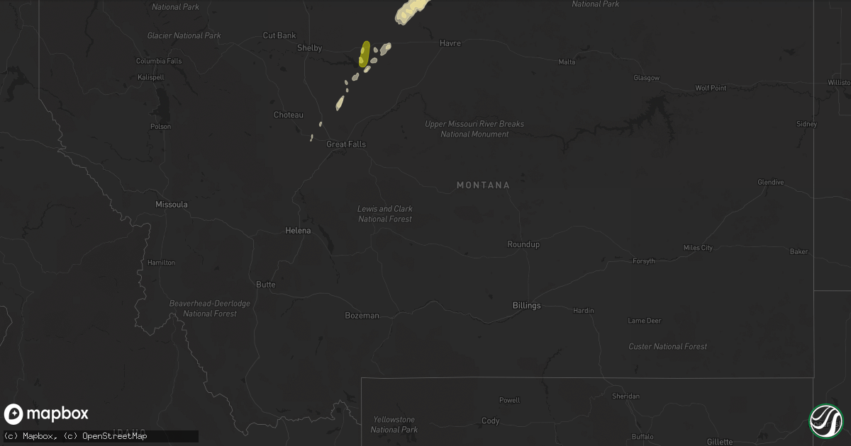
Hail Map in Montana on May 12, 2017
Get this storm
May 12 map
$229
one time, instant access
Download today. No call, no setup
Keep the $229
Bought the map and want the full workflow? Apply the entire $229 to a subscription within 7 days. None of it is wasted.
Every map, not just this one
This buys you this map. Subscription and you get every map we run, in the markets you choose from a few cities to whole states to nationwide. Plus real-time alerts the moment a storm fires.
Contact data
Name, contact info, occupancy, even credit band for addresses in the footprint. You go from where it hit to who to call.
Become the source they trust
Unlimited branding weather history reports on demand. You already have the documented answer ready for the property owner, and you are the one who showed up with it.
Property data and RoofTrace estimates
Pull up any address you have got, its value and the exact code rules for that jurisdiction, straight from One Click Code. Then RoofTrace estimates the squares, pitch, and roof value, priced the way you price.
Storm reports in Montana
Montana
| Date | Description |
|---|---|
| 05/12/20176:13 PM CDT | Sheriffs department estimated quarter size hail at the office. Time estimated based on radar. |
| 05/12/20176:04 PM CDT | 60 mph wind gust at the dot sensor just north of loma |
| 05/12/20176:03 PM CDT | Trained spotter reports several power poles blown down on hwy 223 south of chester. Fire department is on scene directing traffic. Spotter reported hail but size was un |
| 05/12/20175:31 PM CDT | Mesonet station e1937... 20 n rudyard. |
| 05/12/20175:29 PM CDT | 61 mph wind gust. |
| 05/12/20175:25 PM CDT | Estimated wind gusts in the upper 50 mph range. Penny size hail. Tree limbs down. Crop damage. Estimated time of event. |
| 05/12/20175:02 PM CDT | 70 mph wind gust at the dot sensor just east of inverness. |
| 05/12/20174:32 PM CDT | Two power poles blown down in thunderstorm winds. Highway 223 mm 42. Spotter reports poles just downed upon arrival arcing live power |
All States Impacted by Hail Map on May 12, 2017
Cities Impacted by Hail Map on May 12, 2017
- Hingham, MT
- Fort Shaw, MT
- Jackson, LA
- Zachary, LA
- Gildford, MT
- Grayson, GA
- Lawrenceville, GA
- Rudyard, MT
- Inverness, MT
- Charleston, MS
- Carter, MT
- La Place, LA
- Chester, MT
- Holden, LA
- Greenwood, SC
- Saint Gabriel, LA
- Havre, MT
- Lakeland, LA
- Independence, LA
- Ponchatoula, LA
- Tickfaw, LA
- Baton Rouge, LA
- Baker, LA
- Port Allen, LA
- Livingston, LA
- Rougon, LA
- Erwinville, LA
- Denham Springs, LA
- Greenwell Springs, LA
- Albany, LA
- Hammond, LA
- Pride, LA
- Walker, LA
- Glynn, LA
- Lilburn, GA
- Stone Mountain, GA
- Norcross, GA
- Tucker, GA
- Prairieville, LA
- Gonzales, LA
- Geismar, LA
- White Castle, LA
- Sunshine, LA
- Plaquemine, LA
- Donaldsonville, LA
- Carville, LA
- Grenada, MS
- Anderson, SC
- Starr, SC
- Saint Francisville, LA
- Brady, MT
- Dutton, MT
- Carthage, MS
- Lena, MS
- Power, MT
- Madisonville, LA
- Gulfport, MS
- Ethel, LA
- Jarreau, LA
- Ventress, LA
- Slaughter, LA
- Oscar, LA
- Livonia, LA
- Abbeville, SC
- Kinston, AL
- Opp, AL
- Ledger, MT
- Pinson, AL
- Birmingham, AL
- Kimberly, AL
- Gardendale, AL
- Remlap, AL
- Mount Olive, AL
- Graysville, AL
- Morris, AL
- Snellville, GA
- Mandeville, LA
- Covington, LA
- Pearl River, LA
- Stennis Space Center, MS
- Bay Saint Louis, MS
- Fort Benton, MT
- Kosciusko, MS
- Maurepas, LA
- Belle Chasse, LA
- Braithwaite, LA
- New Orleans, LA
- Osyka, MS
- Iva, SC
- Saint Amant, LA
- Belle Rose, LA
- Belton, SC
- Clinton, LA
- Hamburg, AR
- Wellington, AL
- Jacksonville, AL
- Grosse Tete, LA
- Darrow, LA
- Ashville, AL
- Bradley, SC
- Magnolia, MS
- Kentwood, LA
- Liberty, MS
- Greensburg, LA
- Burnsville, MS
- Trussville, AL
- Springville, AL
- Pierre Part, LA
- Springfield, LA
- Walnut Grove, MS
- Bristol, TN


