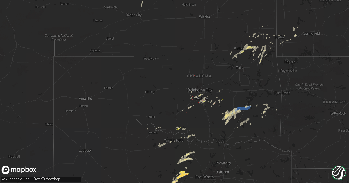
Hail Map in Oklahoma on May 11, 2023
Get this storm
May 11 map
$229
one time, instant access
Download today. No call, no setup
Keep the $229
Bought the map and want the full workflow? Apply the entire $229 to a subscription within 7 days. None of it is wasted.
Every map, not just this one
This buys you this map. Subscription and you get every map we run, in the markets you choose from a few cities to whole states to nationwide. Plus real-time alerts the moment a storm fires.
Contact data
Name, contact info, occupancy, even credit band for addresses in the footprint. You go from where it hit to who to call.
Become the source they trust
Unlimited branding weather history reports on demand. You already have the documented answer ready for the property owner, and you are the one who showed up with it.
Property data and RoofTrace estimates
Pull up any address you have got, its value and the exact code rules for that jurisdiction, straight from One Click Code. Then RoofTrace estimates the squares, pitch, and roof value, priced the way you price.
Storm reports in Oklahoma
Oklahoma
| Date | Description |
|---|---|
| 05/11/20235:20 PM CDT | A local report indicates 1.00 inch wind near 4 W TEMPLE |
| 05/11/202312:37 AM CDT | Report from mping: quarter |
| 05/11/202312:30 AM CDT | Large tree down on power lines. |
| 05/11/202312:21 AM CDT | Reported at mcalester airport. |
| 05/10/202311:40 PM CDT | Reported at stuart mesonet site. |
| 05/10/202311:03 PM CDT | A local report indicates 1.00 inch wind near 1 N STONEWALL |
| 05/10/202310:21 PM CDT | Spotters and broadcast media observed a tornado approximately 3 miles west of maud. |
| 05/10/202310:09 PM CDT | A local report indicates 1.00 inch wind near 1 N BOWLEGS |
| 05/10/202310:00 PM CDT | Spotternetwork report. |
| 05/10/20239:33 PM CDT | Spotters and broadcast media report a tornado southwest of lake thunderbird. |
| 05/10/20239:07 PM CDT | Spotter network report of tornado in noble. |
| 05/10/20238:42 PM CDT | A local report indicates a tornado near 1 SE COLE |
| 05/10/20238:37 PM CDT | Delayed report from 8:27 pm. Half dollar sized hail reported in moore. |
| 05/10/20238:04 PM CDT | A local report indicates a tornado near 4 SW DIBBLE |
| 05/10/20237:42 PM CDT | Brief tornado. |
| 05/10/20237:35 PM CDT | Broadcast media report of a tornado. Time estimated by radar for the start of this tornado. Investigating several small circulations in this area. |
| 05/10/20237:00 PM CDT | A local report indicates a tornado near 3 SSE TUTTLE |
All States Impacted by Hail Map on May 11, 2023
Cities Impacted by Hail Map on May 11, 2023
- Tallulah, LA
- Vicksburg, MS
- Henrietta, TX
- Joaquin, TX
- Davidson, OK
- Ryan, OK
- Wisner, LA
- Mansfield, LA
- Georgetown, LA
- Pollock, LA
- Trout, LA
- Dry Prong, LA
- Colfax, LA
- Olla, LA
- Wichita Falls, TX
- Calhoun, LA
- Eros, LA
- West Monroe, LA
- Gilbert, LA
- Hastings, OK
- Waurika, OK
- Temple, OK
- Seymour, TX
- Holliday, TX
- Chillicothe, TX
- Grayson, LA
- Kelly, LA
- Ringling, OK
- Enterprise, LA
- Harrisonburg, LA
- Fort Necessity, LA
- Logansport, LA
- Tenaha, TX
- Grand Cane, LA
- Mansura, LA
- Marksville, LA
- Bentley, LA
- Jena, LA
- Petrolia, TX
- Edwards, MS
- McDonald, KS
- Bird City, KS
- Atwood, KS
- Ludell, KS
- Fayette, MS
- Ashland, LA
- Coushatta, LA
- Saline, LA
- Campti, LA
- Goldonna, LA
- Natchitoches, LA
- Robeline, LA
- Roxie, MS
- Winnfield, LA
- Elk Point, SD
- Alcester, SD
- Beresford, SD
- Vermillion, SD
- Burbank, SD
- Levant, KS
- Brookhaven, MS
- Wesson, MS
- Wauneta, NE
- High Springs, FL
- Trenton, FL
- Minden, LA
- Liberty, MS
- Bloomfield, NE
- Winter Garden, FL
- Ocoee, FL
- Homosassa, FL
- Lecanto, FL
- Oak Vale, MS
- Niobrara, NE
- Summit, MS
- Ruth, MS
- Centreville, MS
- Gloster, MS
- Crystal River, FL
- Walters, OK
- McCook, NE
- Bogue Chitto, MS
- Tylertown, MS
- Lake City, FL
- Weskan, KS
- Bowie, TX
- Arapahoe, CO
- Apopka, FL
- Sharon Springs, KS
- Wallace, KS
- Goodland, KS
- Smithdale, MS
- Meadville, MS
- Greensburg, LA
- Sontag, MS
- Kilgore, NE
- Crookston, NE
- Rushville, NE
- Union Church, MS
- McCall Creek, MS
- Woodville, MS
- Davenport, FL
- Mccomb, MS
- Fort White, FL
- Alachua, FL
- Orlando, FL
- Mount Olive, MS
- Hay Springs, NE
- Saint Francis, KS
- Monticello, MS
- Newhebron, MS
- Magee, MS
- Branford, FL
- Holden, LA
- Albany, LA
- Ellsworth, NE
- Natchez, MS
- Leesville, LA
- Clermont, FL
- Wray, CO
- Delhi, LA
- Windermere, FL
- Kissimmee, FL
- Franklinton, LA
- Clinton, LA
- Hazlehurst, MS
- Osyka, MS
- Magnolia, MS
- Lorman, MS
- Bell, FL
- Hennessey, OK
- Tuttle, OK
- Ninnekah, OK
- Amber, OK
- Winona, KS
- Colby, KS
- Jacksboro, TX
- Newcastle, OK
- Blanchard, OK
- Rush Springs, OK
- Alex, OK
- Chico, TX
- Oakley, KS
- Lenora, KS
- Almena, KS
- Washington, OK
- Palo Pinto, TX
- Noble, OK
- Mineral Wells, TX
- Norton, KS
- Omega, GA
- Tifton, GA
- Norman Park, GA
- Sparks, GA
- Norman, OK
- Asher, OK
- Hattiesburg, MS
- Lexington, OK
- Graford, TX
- Weatherford, TX
- Ranger, TX
- Strawn, TX
- Maud, OK
- Seminole, OK
- Perrin, TX
- Merriman, NE
- Florence, AL
- Wanette, OK
- Macomb, OK
- Long Valley, SD
- Springfield, SD
- Yukon, OK
- El Reno, OK
- Mustang, OK
- Naponee, NE
- Bloomington, NE
- Hanston, KS
- Stonewall, OK
- Ada, OK
- Allen, OK
- Carriere, MS
- Konawa, OK
- Silas, AL
- Gordon, TX
- Bellevue, TX
- Enigma, GA
- Toxey, AL
- Sumrall, MS
- Silver Creek, MS
- Bassfield, MS
- Columbia, MS
- Petal, MS
- Quitman, MS
- Ellisville, MS
- Needham, AL
- Gilbertown, AL
- Butler, AL
- Taylorsville, MS
- Prattville, AL
- Deatsville, AL
- Glen Elder, KS
- Richton, MS
- Heidelberg, MS
- Jayess, MS
- Gonzales, LA
- Saint Amant, LA
- Sorrento, LA
- Newellton, LA
- Bogalusa, LA
- Prentiss, MS
- Lenox, GA
- Oklahoma City, OK
- Ellenton, GA
- Perkins, OK
- Foxworth, MS
- Lisman, AL
- Waynesboro, MS
- Pearl River, LA
- Picayune, MS
- White Springs, FL
- Collins, MS
- Tupelo, OK
- Purvis, MS
- Seminary, MS
- Polk City, FL
- Bryson, TX
- Moselle, MS
- Carson, MS
- Kokomo, MS
- Bush, LA
- Bonifay, FL
- Graceville, FL
- Meridian, MS
- Selden, KS
- Denham Springs, LA
- Walker, LA
- Shubuta, MS
- Center, NE
- Sunset, TX
- Bowlegs, OK
- Laurel, MS
- Chickasha, OK
- Dunnellon, FL
- Inglis, FL
- Soso, MS
- Ocilla, GA
- Geismar, LA
- Grinnell, KS
- Fletcher, OK
- Ochelata, OK
- Bartlesville, OK
- Ramona, OK
- Delaware, OK
- Nowata, OK
- Calvin, OK
- Centrahoma, OK
- Coalgate, OK
- Stuart, OK
- Mcalester, OK
- Savanna, OK
- Krebs, OK
- Prague, OK
- Skiatook, OK
- Barnsdall, OK
- Dewey, OK
- Wann, OK
- Lenapah, OK
- Vinita, OK
- Pryor, OK
- Big Cabin, OK
- Adair, OK
- S Coffeyville, OK
- Nashoba, OK
- Joplin, MO
- Webb City, MO
- Wister, OK
- Talihina, OK
- Onida, SD
- Lebanon, SD
- Troy, AL
- Edna, KS
- Altamont, KS
- Chelsea, OK
- Mound Valley, KS
- Coffeyville, KS
- Liberty, KS
- Gem, KS
- Wilburton, OK
- Shawnee, OK
- Heavener, OK
- Highmore, SD
- Claremore, OK
- Stringtown, OK
- Lane, OK
- Purcell, OK
- Roff, OK
- Wapanucka, OK
- Milburn, OK
- Gorman, TX
- Eastland, TX
- Carbon, TX
- Daisy, OK
- Honobia, OK
- Red Oak, OK
- Bluejacket, OK
- Wynona, OK
- Pawhuska, OK
- Fairland, OK
- Quapaw, OK
- Miami, OK
- Columbus, KS
- Greenfield, MO
- South Greenfield, MO
- Stotts City, MO
- Mount Vernon, MO
- Chetopa, KS
- Carthage, MO
- Oswego, KS
- Ovett, MS
- Afton, OK
- Carterville, MO
- Saint Paul, KS
- Miller, MO
- La Russell, MO
- Crosby, MS
- Parsons, KS
- Baxter Springs, KS
- Wentworth, MO
- Camden, MS
- Wellborn, FL
- Live Oak, FL
- Alvord, TX
- McCune, KS
- Girard, KS
- Pine Grove, LA
- Millsap, TX
- Cusseta, GA
- Herndon, KS
- Trenton, NE
- Tecumseh, OK
- Kentwood, LA
- Neosho, MO
- Antlers, OK
- Clayton, OK
- Atoka, OK
- Ketchum, OK
- Lockwood, MO
- Norwood, LA
- Galena, KS
- Mena, AR
- Mingus, TX
- Granby, MO
- Pierce City, MO


