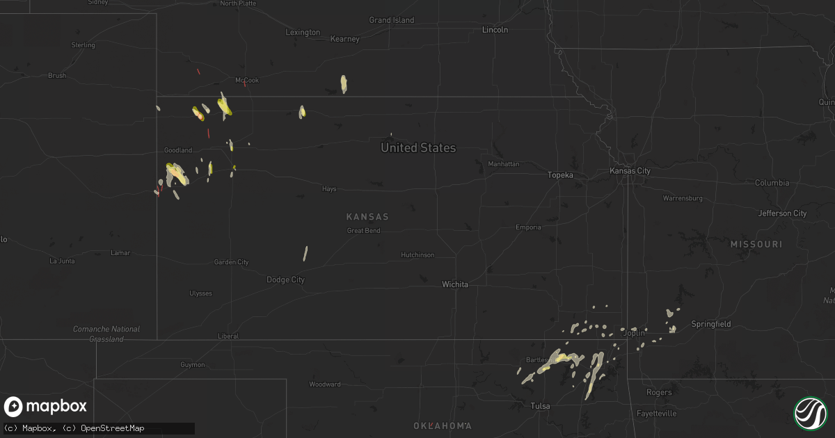
Hail Map in Kansas on May 11, 2023
Get this storm
May 11 map
$229
one time, instant access
Download today. No call, no setup
Keep the $229
Bought the map and want the full workflow? Apply the entire $229 to a subscription within 7 days. None of it is wasted.
Every map, not just this one
This buys you this map. Subscription and you get every map we run, in the markets you choose from a few cities to whole states to nationwide. Plus real-time alerts the moment a storm fires.
Contact data
Name, contact info, occupancy, even credit band for addresses in the footprint. You go from where it hit to who to call.
Become the source they trust
Unlimited branding weather history reports on demand. You already have the documented answer ready for the property owner, and you are the one who showed up with it.
Property data and RoofTrace estimates
Pull up any address you have got, its value and the exact code rules for that jurisdiction, straight from One Click Code. Then RoofTrace estimates the squares, pitch, and roof value, priced the way you price.
Storm reports in Kansas
Kansas
| Date | Description |
|---|---|
| 05/11/20236:47 PM CDT | Photo of tornado 15 miles southeast of goodland... Ks. |
| 05/11/20236:41 PM CDT | Multiple reports of a tornado ongoing at 170 and apache acres. |
| 05/11/20236:35 PM CDT | Spotter reported tornado 15 miles south of edson. |
| 05/11/20236:07 PM CDT | Social media report with video. |
| 05/11/20235:51 PM CDT | Report of a rain-wrapped... Weak tornado that crossed highway 40. |
| 05/11/20235:41 PM CDT | Spotter reported a multi-vortex tornado just southwest of weskan. |
| 05/11/20233:40 PM CDT | Off duty employee reported 60 to 65 mph wind gusts and pea to half inch hail. |
| 05/11/20233:39 PM CDT | Site wpe weather. |
| 05/11/20233:10 PM CDT | Spotter reported brief spin up tornado. Not ongoing as of call at 2012z. |
| 05/11/20231:51 PM CDT | Caller reported a brief tornado at the intersection of road 33 and road q. |
| 05/11/20231:40 PM CDT | Ongoing rain wrapped tornado reported south of mcdonald. |
| 05/10/20238:19 PM CDT | Report of measured hail up to 1 inch. |
| 05/10/20238:11 PM CDT | Trained spotter reports nickel to quarter size hail at hwy 83 and hwy 24. |
| 05/10/20237:51 PM CDT | A couple of brief landspouts were reported around 5 miles west of sublette and just north of highway 160... Around 7:50 to 7:53. Each one lasted a couple of minutes. Lo |
| 05/10/20237:30 PM CDT | Multiple spotters reported a brief tornado. |
| 05/10/20237:04 PM CDT | Spotter reported one inch hail. |
All States Impacted by Hail Map on May 11, 2023
Cities Impacted by Hail Map on May 11, 2023
- Tallulah, LA
- Vicksburg, MS
- Henrietta, TX
- Joaquin, TX
- Davidson, OK
- Ryan, OK
- Wisner, LA
- Mansfield, LA
- Georgetown, LA
- Pollock, LA
- Trout, LA
- Dry Prong, LA
- Colfax, LA
- Olla, LA
- Wichita Falls, TX
- Calhoun, LA
- Eros, LA
- West Monroe, LA
- Gilbert, LA
- Hastings, OK
- Waurika, OK
- Temple, OK
- Seymour, TX
- Holliday, TX
- Chillicothe, TX
- Grayson, LA
- Kelly, LA
- Ringling, OK
- Enterprise, LA
- Harrisonburg, LA
- Fort Necessity, LA
- Logansport, LA
- Tenaha, TX
- Grand Cane, LA
- Mansura, LA
- Marksville, LA
- Bentley, LA
- Jena, LA
- Petrolia, TX
- Edwards, MS
- McDonald, KS
- Bird City, KS
- Atwood, KS
- Ludell, KS
- Fayette, MS
- Ashland, LA
- Coushatta, LA
- Saline, LA
- Campti, LA
- Goldonna, LA
- Natchitoches, LA
- Robeline, LA
- Roxie, MS
- Winnfield, LA
- Elk Point, SD
- Alcester, SD
- Beresford, SD
- Vermillion, SD
- Burbank, SD
- Levant, KS
- Brookhaven, MS
- Wesson, MS
- Wauneta, NE
- High Springs, FL
- Trenton, FL
- Minden, LA
- Liberty, MS
- Bloomfield, NE
- Winter Garden, FL
- Ocoee, FL
- Homosassa, FL
- Lecanto, FL
- Oak Vale, MS
- Niobrara, NE
- Summit, MS
- Ruth, MS
- Centreville, MS
- Gloster, MS
- Crystal River, FL
- Walters, OK
- McCook, NE
- Bogue Chitto, MS
- Tylertown, MS
- Lake City, FL
- Weskan, KS
- Bowie, TX
- Arapahoe, CO
- Apopka, FL
- Sharon Springs, KS
- Wallace, KS
- Goodland, KS
- Smithdale, MS
- Meadville, MS
- Greensburg, LA
- Sontag, MS
- Kilgore, NE
- Crookston, NE
- Rushville, NE
- Union Church, MS
- McCall Creek, MS
- Woodville, MS
- Davenport, FL
- Mccomb, MS
- Fort White, FL
- Alachua, FL
- Orlando, FL
- Mount Olive, MS
- Hay Springs, NE
- Saint Francis, KS
- Monticello, MS
- Newhebron, MS
- Magee, MS
- Branford, FL
- Holden, LA
- Albany, LA
- Ellsworth, NE
- Natchez, MS
- Leesville, LA
- Clermont, FL
- Wray, CO
- Delhi, LA
- Windermere, FL
- Kissimmee, FL
- Franklinton, LA
- Clinton, LA
- Hazlehurst, MS
- Osyka, MS
- Magnolia, MS
- Lorman, MS
- Bell, FL
- Hennessey, OK
- Tuttle, OK
- Ninnekah, OK
- Amber, OK
- Winona, KS
- Colby, KS
- Jacksboro, TX
- Newcastle, OK
- Blanchard, OK
- Rush Springs, OK
- Alex, OK
- Chico, TX
- Oakley, KS
- Lenora, KS
- Almena, KS
- Washington, OK
- Palo Pinto, TX
- Noble, OK
- Mineral Wells, TX
- Norton, KS
- Omega, GA
- Tifton, GA
- Norman Park, GA
- Sparks, GA
- Norman, OK
- Asher, OK
- Hattiesburg, MS
- Lexington, OK
- Graford, TX
- Weatherford, TX
- Ranger, TX
- Strawn, TX
- Maud, OK
- Seminole, OK
- Perrin, TX
- Merriman, NE
- Florence, AL
- Wanette, OK
- Macomb, OK
- Long Valley, SD
- Springfield, SD
- Yukon, OK
- El Reno, OK
- Mustang, OK
- Naponee, NE
- Bloomington, NE
- Hanston, KS
- Stonewall, OK
- Ada, OK
- Allen, OK
- Carriere, MS
- Konawa, OK
- Silas, AL
- Gordon, TX
- Bellevue, TX
- Enigma, GA
- Toxey, AL
- Sumrall, MS
- Silver Creek, MS
- Bassfield, MS
- Columbia, MS
- Petal, MS
- Quitman, MS
- Ellisville, MS
- Needham, AL
- Gilbertown, AL
- Butler, AL
- Taylorsville, MS
- Prattville, AL
- Deatsville, AL
- Glen Elder, KS
- Richton, MS
- Heidelberg, MS
- Jayess, MS
- Gonzales, LA
- Saint Amant, LA
- Sorrento, LA
- Newellton, LA
- Bogalusa, LA
- Prentiss, MS
- Lenox, GA
- Oklahoma City, OK
- Ellenton, GA
- Perkins, OK
- Foxworth, MS
- Lisman, AL
- Waynesboro, MS
- Pearl River, LA
- Picayune, MS
- White Springs, FL
- Collins, MS
- Tupelo, OK
- Purvis, MS
- Seminary, MS
- Polk City, FL
- Bryson, TX
- Moselle, MS
- Carson, MS
- Kokomo, MS
- Bush, LA
- Bonifay, FL
- Graceville, FL
- Meridian, MS
- Selden, KS
- Denham Springs, LA
- Walker, LA
- Shubuta, MS
- Center, NE
- Sunset, TX
- Bowlegs, OK
- Laurel, MS
- Chickasha, OK
- Dunnellon, FL
- Inglis, FL
- Soso, MS
- Ocilla, GA
- Geismar, LA
- Grinnell, KS
- Fletcher, OK
- Ochelata, OK
- Bartlesville, OK
- Ramona, OK
- Delaware, OK
- Nowata, OK
- Calvin, OK
- Centrahoma, OK
- Coalgate, OK
- Stuart, OK
- Mcalester, OK
- Savanna, OK
- Krebs, OK
- Prague, OK
- Skiatook, OK
- Barnsdall, OK
- Dewey, OK
- Wann, OK
- Lenapah, OK
- Vinita, OK
- Pryor, OK
- Big Cabin, OK
- Adair, OK
- S Coffeyville, OK
- Nashoba, OK
- Joplin, MO
- Webb City, MO
- Wister, OK
- Talihina, OK
- Onida, SD
- Lebanon, SD
- Troy, AL
- Edna, KS
- Altamont, KS
- Chelsea, OK
- Mound Valley, KS
- Coffeyville, KS
- Liberty, KS
- Gem, KS
- Wilburton, OK
- Shawnee, OK
- Heavener, OK
- Highmore, SD
- Claremore, OK
- Stringtown, OK
- Lane, OK
- Purcell, OK
- Roff, OK
- Wapanucka, OK
- Milburn, OK
- Gorman, TX
- Eastland, TX
- Carbon, TX
- Daisy, OK
- Honobia, OK
- Red Oak, OK
- Bluejacket, OK
- Wynona, OK
- Pawhuska, OK
- Fairland, OK
- Quapaw, OK
- Miami, OK
- Columbus, KS
- Greenfield, MO
- South Greenfield, MO
- Stotts City, MO
- Mount Vernon, MO
- Chetopa, KS
- Carthage, MO
- Oswego, KS
- Ovett, MS
- Afton, OK
- Carterville, MO
- Saint Paul, KS
- Miller, MO
- La Russell, MO
- Crosby, MS
- Parsons, KS
- Baxter Springs, KS
- Wentworth, MO
- Camden, MS
- Wellborn, FL
- Live Oak, FL
- Alvord, TX
- McCune, KS
- Girard, KS
- Pine Grove, LA
- Millsap, TX
- Cusseta, GA
- Herndon, KS
- Trenton, NE
- Tecumseh, OK
- Kentwood, LA
- Neosho, MO
- Antlers, OK
- Clayton, OK
- Atoka, OK
- Ketchum, OK
- Lockwood, MO
- Norwood, LA
- Galena, KS
- Mena, AR
- Mingus, TX
- Granby, MO
- Pierce City, MO


