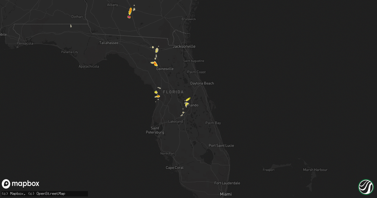
Hail Map on May 11, 2023
Get this storm
May 11 map
$229
one time, instant access
Download today. No call, no setup
Keep the $229
Bought the map and want the full workflow? Apply the entire $229 to a subscription within 7 days. None of it is wasted.
Every map, not just this one
This buys you this map. Subscription and you get every map we run, in the markets you choose from a few cities to whole states to nationwide. Plus real-time alerts the moment a storm fires.
Contact data
Name, contact info, occupancy, even credit band for addresses in the footprint. You go from where it hit to who to call.
Become the source they trust
Unlimited branding weather history reports on demand. You already have the documented answer ready for the property owner, and you are the one who showed up with it.
Property data and RoofTrace estimates
Pull up any address you have got, its value and the exact code rules for that jurisdiction, straight from One Click Code. Then RoofTrace estimates the squares, pitch, and roof value, priced the way you price.
States Impacted by Hail Map on May 11, 2023
Storm reports
Mississippi
| Date | Description |
|---|---|
| 05/11/20236:15 PM CDT | Quarter size hail fell near oak grove. |
| 05/11/20235:33 PM CDT | Tree down in the carmichael community. |
| 05/11/20235:33 PM CDT | Tree down in the glade commnunity. |
| 05/11/20235:30 PM CDT | Tree down near eastabuchie. |
| 05/11/20234:55 PM CDT | Delayed report. A utility pole was damaged in the zero community. |
| 05/11/20234:28 PM CDT | Penny to quarter sized hail last for about 4 min. |
| 05/11/20234:21 PM CDT | Trees and power lines downed along lake valley dr near westwood rd. |
| 05/11/20234:17 PM CDT | Quarter size hail fell near bogue chitto. |
| 05/11/20233:58 PM CDT | Tree down across the trace near mm 198. |
| 05/11/20233:53 PM CDT | Tree down on concord bethsalem rd. |
| 05/11/20233:40 PM CDT | Large tree limbs down in the eudora community. |
| 05/11/20233:32 PM CDT | Tree down... Blocking highway 487. |
| 05/11/20233:32 PM CDT | Corrects previous tstm wnd dmg report from puckett. Tree down on hghiway 18 near puckett. |
| 05/11/20233:30 PM CDT | Tree downed on ms 413 in kilmichael. |
| 05/11/20233:20 PM CDT | Trees downed on middleton rd and fairground st in winona. |
| 05/11/20232:57 PM CDT | Tree down on highway 16w. |
| 05/11/20232:56 PM CDT | Golf ball size hail reported near roxie. |
| 05/11/20232:56 PM CDT | Couple trees downed in the western part of the county including one on cr 4202 and one near mcadams. |
| 05/11/20232:42 PM CDT | Social media reported a tree fell on a shed. |
| 05/11/20232:36 PM CDT | Trees downed around goodman and pickens. |
| 05/11/20232:32 PM CDT | Tree down on hiway 18 near puckett. |
| 05/11/20232:25 PM CDT | Tree down near holly bush and highway 43. |
| 05/11/20232:20 PM CDT | Tree down on spillway road. |
| 05/11/20232:09 PM CDT | Two trees down in the median between mile markers 62 and 63 on interstate 55. |
| 05/11/20232:08 PM CDT | Tree down... Davis and dunn roads. |
| 05/11/20232:00 PM CDT | Tree down on maclean road. |
| 05/11/20231:56 PM CDT | Tree blocking road. |
| 05/11/20231:50 PM CDT | Tree downed in little yazoo. |
| 05/11/20231:50 PM CDT | Tree downed in bentonia. |
| 05/11/20231:37 PM CDT | Tree downed in satartia. |
| 05/11/20231:35 PM CDT | Tree down near middle road and old port gibson. |
| 05/11/20231:32 PM CDT | Tree down across old port gibson rd. |
| 05/11/20231:15 PM CDT | A few trees down in town. |
| 05/11/20231:15 PM CDT | A few trees down on s side of town. |
Texas
| Date | Description |
|---|---|
| 05/11/20236:50 PM CDT | A local report indicates 1.00 inch wind near 3 SW BOWIE |
| 05/10/202310:22 PM CDT | A local report indicates 1.75 inch wind near 1 SE MINERAL WELLS |
| 05/10/202310:03 PM CDT | A local report indicates 1.75 inch wind near 5 WSW MINERAL WELLS |
| 05/10/20239:57 PM CDT | Report from mping: ping pong ball |
| 05/10/20239:52 PM CDT | A local report indicates 1.00 inch wind near 4 WSW MINERAL WELLS |
| 05/10/20238:45 PM CDT | A local report indicates 2.50 inch wind near 7 NNW GORMAN |
| 05/10/20237:55 PM CDT | A local report indicates 1.00 inch wind near 6 WNW CHICO |
| 05/10/20237:28 PM CDT | West of cundiff on 1810. |
Florida
| Date | Description |
|---|---|
| 05/11/20235:57 PM CDT | Delayed report. Quarter size hail near the lake city airport. Public report sent via social media. |
| 05/11/20234:46 PM CDT | Trained spotter reports half dollar sized hail near lake apopka. |
| 05/11/20234:42 PM CDT | Picture from homosassa springs shows half dollar-sized hail. |
| 05/11/20234:40 PM CDT | Picture from homosassa springs shows ping pong ball size hail. |
| 05/11/20234:30 PM CDT | Trained spotter reports quarter sized hail near lake apopka. |
| 05/11/20234:30 PM CDT | Reports of a mix of hail sizes... Pea to golf ball sized... Just southwest of high springs. |
| 05/11/20233:55 PM CDT | Photos of ping pong size hail reported west of high springs by a trained spotter... Relayed by em. Exact location estimated from radar. |
Colorado
| Date | Description |
|---|---|
| 05/11/20235:45 PM CDT | Trained spotter reported about 3 miles southeast of arapahoe... Co. Tornadoes are short lived only lasting a minute or so... Lifting... And dropping again. Multi-vortex |
| 05/11/20235:45 PM CDT | Spotter reported two tornadoes 2 east and 1.5 miles south of arapahoe. |
| 05/11/20231:25 PM CDT | Coagmet site at kirk |
| 05/11/202312:59 PM CDT | Potential tds noted on radar beginning at 1759z and ending at 1803z. |
Nebraska
| Date | Description |
|---|---|
| 05/11/20235:26 PM CDT | A local report indicates 58 MPH wind near 1 S VALENTINE |
| 05/11/20235:15 PM CDT | Relayed report from dispatch of a public report of a tornado on the ground. Could not confirm if it was still on the ground. |
| 05/11/20234:47 PM CDT | Trained spotter estimated wind gusts to 60 mph. |
| 05/11/20233:04 PM CDT | Social media report of possible tornado |
| 05/11/20235:48 AM CDT | Substantial damage to outbuildings on a farm. Delayed report. |
South Dakota
| Date | Description |
|---|---|
| 05/11/20234:41 PM CDT | Flag pole snapped off by thunderstorm wind gust. Also had heavy rain... Pea sized hail... And numerous branches broken in yard. |
| 05/11/20234:35 PM CDT | Corrects previous hail report from springfield. Report via social media. |
| 05/11/20233:05 PM CDT | Several trees snapped. |
| 05/11/20233:02 PM CDT | Semi truck tipped over near mile marker 36 on i-29. |
Louisiana
| Date | Description |
|---|---|
| 05/11/20236:35 PM CDT | A tornado that was captured by video briefly touched down along us-71 and tracked parallel to rigolette rd. Along its path... It downed large branches and uprooted and |
| 05/11/20231:06 PM CDT | Tree down near yucatan and sac-a-lait rd. |
| 05/11/202312:56 PM CDT | Tree down across hwy 589 near hwy 2. |
| 05/11/202312:36 PM CDT | Powerline down at hwy 80. |
| 05/11/202312:36 PM CDT | Powerline down on hwy 80. |
| 05/11/202312:26 PM CDT | Power line downed. |
| 05/11/202312:20 PM CDT | Tree down along hwy 555. |
| 05/11/202312:15 PM CDT | Tree down across jones landing rd. |
| 05/11/202312:04 PM CDT | Trees downed. |
| 05/11/202312:03 PM CDT | Social media report of trees snapped and signs bent along us 425 near la 584 south of rayville. |
| 05/11/202311:35 AM CDT | Tree reported down across hwy 133. |
| 05/11/202311:25 AM CDT | Trees reported down across a roadway in the city of winnfield. |
| 05/11/202310:59 AM CDT | Corrects previous tornado report from 9 n sterlington. Corrects time previous tornado report from 9 n sterlington. An ef-1 tornado with maximum winds of 95 mph briefly |
| 05/11/202310:20 AM CDT | Tree reported down across the southbound lane of hwy 167... North of dodson... La. Resources were activated to clear the lane. |
| 05/11/202310:10 AM CDT | Tree reported down in the creston... La area. |
| 05/11/20239:15 AM CDT | Multiple trees down and power line damage around the city of martin... La. |
| 05/11/20238:21 AM CDT | A tornado briefly touched down off of fuller road and doerge lane. Along its path it uprooted 6 hardwood trees in a convergent pattern. It also damaged the roof of a sm |
| 05/11/20238:03 AM CDT | Corrects previous tornado report from 6 ese colfax. A tornado that was captured by video briefly touched down along us-71 and tracked parallel to rigolette rd. Along it |
| 05/11/20237:55 AM CDT | Short ef-1 tornado track crossed high 763 south of stanley. Many trees were snapped and uprooted with a few structures sustaining light to moderate damage due to winds. |
Oklahoma
| Date | Description |
|---|---|
| 05/11/20235:20 PM CDT | A local report indicates 1.00 inch wind near 4 W TEMPLE |
| 05/11/202312:37 AM CDT | Report from mping: quarter |
| 05/11/202312:30 AM CDT | Large tree down on power lines. |
| 05/11/202312:21 AM CDT | Reported at mcalester airport. |
| 05/10/202311:40 PM CDT | Reported at stuart mesonet site. |
| 05/10/202311:03 PM CDT | A local report indicates 1.00 inch wind near 1 N STONEWALL |
| 05/10/202310:21 PM CDT | Spotters and broadcast media observed a tornado approximately 3 miles west of maud. |
| 05/10/202310:09 PM CDT | A local report indicates 1.00 inch wind near 1 N BOWLEGS |
| 05/10/202310:00 PM CDT | Spotternetwork report. |
| 05/10/20239:33 PM CDT | Spotters and broadcast media report a tornado southwest of lake thunderbird. |
| 05/10/20239:07 PM CDT | Spotter network report of tornado in noble. |
| 05/10/20238:42 PM CDT | A local report indicates a tornado near 1 SE COLE |
| 05/10/20238:37 PM CDT | Delayed report from 8:27 pm. Half dollar sized hail reported in moore. |
| 05/10/20238:04 PM CDT | A local report indicates a tornado near 4 SW DIBBLE |
| 05/10/20237:42 PM CDT | Brief tornado. |
| 05/10/20237:35 PM CDT | Broadcast media report of a tornado. Time estimated by radar for the start of this tornado. Investigating several small circulations in this area. |
| 05/10/20237:00 PM CDT | A local report indicates a tornado near 3 SSE TUTTLE |
Tennessee
| Date | Description |
|---|---|
| 05/11/20234:39 PM CDT | Large tree limb knocked down the power line to a house. |
Arkansas
| Date | Description |
|---|---|
| 05/11/202312:11 PM CDT | Many uprooted softwood trees and roof blow off house. |
| 05/11/202312:11 PM CDT | Corrects previous tstm wnd dmg report from 3 nnw hamburg. Many uprooted softwood trees and roof blow off house. |
| 05/11/202311:08 AM CDT | Trees and power lines down... About 3 miles west of rison... Ar along hwy 35. |
Georgia
| Date | Description |
|---|---|
| 05/10/20239:20 PM CDT | Report of golf ball size hail in the northern tifton city limits. |
| 05/10/20239:20 PM CDT | Nickel to quarter size hail along 40th street with a few pieces slightly larger than quarters. |
| 05/10/20239:15 PM CDT | Photo of a tree down in a yard near whiddon mill road and carpenter road. |
| 05/10/20239:13 PM CDT | Report of quarter size hail in north tifton. |
| 05/10/20239:12 PM CDT | Video of hail estimated near ping pong ball size off 20th street in tifton. |
| 05/10/20239:08 PM CDT | Multiple trees reported down along the highway in downtown tifton. |
| 05/10/20239:08 PM CDT | Multiple reports of quarter size hail in downtown tifton. |
| 05/10/20239:07 PM CDT | A local report indicates 1.00 inch wind near 1 WNW TIFTON |
| 05/10/20238:55 PM CDT | Picture of hail estimated around ping pong ball size from the kelltown area south of tifton. |
| 05/10/20238:30 PM CDT | Reports of golf ball size hail in cool springs around ellenton omega rd. |
| 05/10/20238:30 PM CDT | Photo of hail measured at 2.5 inches in diameter from eastern colquitt county not far from ellenton. |
Kansas
| Date | Description |
|---|---|
| 05/11/20236:47 PM CDT | Photo of tornado 15 miles southeast of goodland... Ks. |
| 05/11/20236:41 PM CDT | Multiple reports of a tornado ongoing at 170 and apache acres. |
| 05/11/20236:35 PM CDT | Spotter reported tornado 15 miles south of edson. |
| 05/11/20236:07 PM CDT | Social media report with video. |
| 05/11/20235:51 PM CDT | Report of a rain-wrapped... Weak tornado that crossed highway 40. |
| 05/11/20235:41 PM CDT | Spotter reported a multi-vortex tornado just southwest of weskan. |
| 05/11/20233:40 PM CDT | Off duty employee reported 60 to 65 mph wind gusts and pea to half inch hail. |
| 05/11/20233:39 PM CDT | Site wpe weather. |
| 05/11/20233:10 PM CDT | Spotter reported brief spin up tornado. Not ongoing as of call at 2012z. |
| 05/11/20231:51 PM CDT | Caller reported a brief tornado at the intersection of road 33 and road q. |
| 05/11/20231:40 PM CDT | Ongoing rain wrapped tornado reported south of mcdonald. |
| 05/10/20238:19 PM CDT | Report of measured hail up to 1 inch. |
| 05/10/20238:11 PM CDT | Trained spotter reports nickel to quarter size hail at hwy 83 and hwy 24. |
| 05/10/20237:51 PM CDT | A couple of brief landspouts were reported around 5 miles west of sublette and just north of highway 160... Around 7:50 to 7:53. Each one lasted a couple of minutes. Lo |
| 05/10/20237:30 PM CDT | Multiple spotters reported a brief tornado. |
| 05/10/20237:04 PM CDT | Spotter reported one inch hail. |
Alabama
| Date | Description |
|---|---|
| 05/10/20237:00 PM CDT | Trees down at waterloo high school. |
Cities Impacted by Hail Map on May 11, 2023
- Tallulah, LA
- Vicksburg, MS
- Henrietta, TX
- Joaquin, TX
- Davidson, OK
- Ryan, OK
- Wisner, LA
- Mansfield, LA
- Georgetown, LA
- Pollock, LA
- Trout, LA
- Dry Prong, LA
- Colfax, LA
- Olla, LA
- Wichita Falls, TX
- Calhoun, LA
- Eros, LA
- West Monroe, LA
- Gilbert, LA
- Hastings, OK
- Waurika, OK
- Temple, OK
- Seymour, TX
- Holliday, TX
- Chillicothe, TX
- Grayson, LA
- Kelly, LA
- Ringling, OK
- Enterprise, LA
- Harrisonburg, LA
- Fort Necessity, LA
- Logansport, LA
- Tenaha, TX
- Grand Cane, LA
- Mansura, LA
- Marksville, LA
- Bentley, LA
- Jena, LA
- Petrolia, TX
- Edwards, MS
- McDonald, KS
- Bird City, KS
- Atwood, KS
- Ludell, KS
- Fayette, MS
- Ashland, LA
- Coushatta, LA
- Saline, LA
- Campti, LA
- Goldonna, LA
- Natchitoches, LA
- Robeline, LA
- Roxie, MS
- Winnfield, LA
- Elk Point, SD
- Alcester, SD
- Beresford, SD
- Vermillion, SD
- Burbank, SD
- Levant, KS
- Brookhaven, MS
- Wesson, MS
- Wauneta, NE
- High Springs, FL
- Trenton, FL
- Minden, LA
- Liberty, MS
- Bloomfield, NE
- Winter Garden, FL
- Ocoee, FL
- Homosassa, FL
- Lecanto, FL
- Oak Vale, MS
- Niobrara, NE
- Summit, MS
- Ruth, MS
- Centreville, MS
- Gloster, MS
- Crystal River, FL
- Walters, OK
- McCook, NE
- Bogue Chitto, MS
- Tylertown, MS
- Lake City, FL
- Weskan, KS
- Bowie, TX
- Arapahoe, CO
- Apopka, FL
- Sharon Springs, KS
- Wallace, KS
- Goodland, KS
- Smithdale, MS
- Meadville, MS
- Greensburg, LA
- Sontag, MS
- Kilgore, NE
- Crookston, NE
- Rushville, NE
- Union Church, MS
- McCall Creek, MS
- Woodville, MS
- Davenport, FL
- Mccomb, MS
- Fort White, FL
- Alachua, FL
- Orlando, FL
- Mount Olive, MS
- Hay Springs, NE
- Saint Francis, KS
- Monticello, MS
- Newhebron, MS
- Magee, MS
- Branford, FL
- Holden, LA
- Albany, LA
- Ellsworth, NE
- Natchez, MS
- Leesville, LA
- Clermont, FL
- Wray, CO
- Delhi, LA
- Windermere, FL
- Kissimmee, FL
- Franklinton, LA
- Clinton, LA
- Hazlehurst, MS
- Osyka, MS
- Magnolia, MS
- Lorman, MS
- Bell, FL
- Hennessey, OK
- Tuttle, OK
- Ninnekah, OK
- Amber, OK
- Winona, KS
- Colby, KS
- Jacksboro, TX
- Newcastle, OK
- Blanchard, OK
- Rush Springs, OK
- Alex, OK
- Chico, TX
- Oakley, KS
- Lenora, KS
- Almena, KS
- Washington, OK
- Palo Pinto, TX
- Noble, OK
- Mineral Wells, TX
- Norton, KS
- Omega, GA
- Tifton, GA
- Norman Park, GA
- Sparks, GA
- Norman, OK
- Asher, OK
- Hattiesburg, MS
- Lexington, OK
- Graford, TX
- Weatherford, TX
- Ranger, TX
- Strawn, TX
- Maud, OK
- Seminole, OK
- Perrin, TX
- Merriman, NE
- Florence, AL
- Wanette, OK
- Macomb, OK
- Long Valley, SD
- Springfield, SD
- Yukon, OK
- El Reno, OK
- Mustang, OK
- Naponee, NE
- Bloomington, NE
- Hanston, KS
- Stonewall, OK
- Ada, OK
- Allen, OK
- Carriere, MS
- Konawa, OK
- Silas, AL
- Gordon, TX
- Bellevue, TX
- Enigma, GA
- Toxey, AL
- Sumrall, MS
- Silver Creek, MS
- Bassfield, MS
- Columbia, MS
- Petal, MS
- Quitman, MS
- Ellisville, MS
- Needham, AL
- Gilbertown, AL
- Butler, AL
- Taylorsville, MS
- Prattville, AL
- Deatsville, AL
- Glen Elder, KS
- Richton, MS
- Heidelberg, MS
- Jayess, MS
- Gonzales, LA
- Saint Amant, LA
- Sorrento, LA
- Newellton, LA
- Bogalusa, LA
- Prentiss, MS
- Lenox, GA
- Oklahoma City, OK
- Ellenton, GA
- Perkins, OK
- Foxworth, MS
- Lisman, AL
- Waynesboro, MS
- Pearl River, LA
- Picayune, MS
- White Springs, FL
- Collins, MS
- Tupelo, OK
- Purvis, MS
- Seminary, MS
- Polk City, FL
- Bryson, TX
- Moselle, MS
- Carson, MS
- Kokomo, MS
- Bush, LA
- Bonifay, FL
- Graceville, FL
- Meridian, MS
- Selden, KS
- Denham Springs, LA
- Walker, LA
- Shubuta, MS
- Center, NE
- Sunset, TX
- Bowlegs, OK
- Laurel, MS
- Chickasha, OK
- Dunnellon, FL
- Inglis, FL
- Soso, MS
- Ocilla, GA
- Geismar, LA
- Grinnell, KS
- Fletcher, OK
- Ochelata, OK
- Bartlesville, OK
- Ramona, OK
- Delaware, OK
- Nowata, OK
- Calvin, OK
- Centrahoma, OK
- Coalgate, OK
- Stuart, OK
- Mcalester, OK
- Savanna, OK
- Krebs, OK
- Prague, OK
- Skiatook, OK
- Barnsdall, OK
- Dewey, OK
- Wann, OK
- Lenapah, OK
- Vinita, OK
- Pryor, OK
- Big Cabin, OK
- Adair, OK
- S Coffeyville, OK
- Nashoba, OK
- Joplin, MO
- Webb City, MO
- Wister, OK
- Talihina, OK
- Onida, SD
- Lebanon, SD
- Troy, AL
- Edna, KS
- Altamont, KS
- Chelsea, OK
- Mound Valley, KS
- Coffeyville, KS
- Liberty, KS
- Gem, KS
- Wilburton, OK
- Shawnee, OK
- Heavener, OK
- Highmore, SD
- Claremore, OK
- Stringtown, OK
- Lane, OK
- Purcell, OK
- Roff, OK
- Wapanucka, OK
- Milburn, OK
- Gorman, TX
- Eastland, TX
- Carbon, TX
- Daisy, OK
- Honobia, OK
- Red Oak, OK
- Bluejacket, OK
- Wynona, OK
- Pawhuska, OK
- Fairland, OK
- Quapaw, OK
- Miami, OK
- Columbus, KS
- Greenfield, MO
- South Greenfield, MO
- Stotts City, MO
- Mount Vernon, MO
- Chetopa, KS
- Carthage, MO
- Oswego, KS
- Ovett, MS
- Afton, OK
- Carterville, MO
- Saint Paul, KS
- Miller, MO
- La Russell, MO
- Crosby, MS
- Parsons, KS
- Baxter Springs, KS
- Wentworth, MO
- Camden, MS
- Wellborn, FL
- Live Oak, FL
- Alvord, TX
- McCune, KS
- Girard, KS
- Pine Grove, LA
- Millsap, TX
- Cusseta, GA
- Herndon, KS
- Trenton, NE
- Tecumseh, OK
- Kentwood, LA
- Neosho, MO
- Antlers, OK
- Clayton, OK
- Atoka, OK
- Ketchum, OK
- Lockwood, MO
- Norwood, LA
- Galena, KS
- Mena, AR
- Mingus, TX
- Granby, MO
- Pierce City, MO