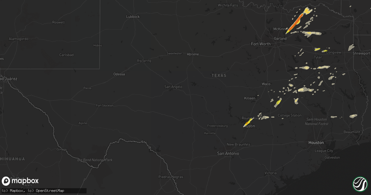
Hail Map in Texas on May 11, 2017
Get this storm
May 11 map
$229
one time, instant access
Download today. No call, no setup
Keep the $229
Bought the map and want the full workflow? Apply the entire $229 to a subscription within 7 days. None of it is wasted.
Every map, not just this one
This buys you this map. Subscription and you get every map we run, in the markets you choose from a few cities to whole states to nationwide. Plus real-time alerts the moment a storm fires.
Contact data
Name, contact info, occupancy, even credit band for addresses in the footprint. You go from where it hit to who to call.
Become the source they trust
Unlimited branding weather history reports on demand. You already have the documented answer ready for the property owner, and you are the one who showed up with it.
Property data and RoofTrace estimates
Pull up any address you have got, its value and the exact code rules for that jurisdiction, straight from One Click Code. Then RoofTrace estimates the squares, pitch, and roof value, priced the way you price.
Storm reports in Texas
Texas
| Date | Description |
|---|---|
| 05/11/20176:52 PM CDT | Quarter size hail 1/2 mile north of interstate 20 on hwy 155. |
| 05/11/20176:30 PM CDT | Roof off of a church. |
| 05/11/20176:25 PM CDT | Power lines down in warren city. |
| 05/11/20176:23 PM CDT | An ef-1 tornado with maximum estimated winds of 100-110 mph touched down along north white oak road near the upshur/gregg county line on the edge of the union grove inc |
| 05/11/20176:20 PM CDT | A tree fell onto power lines on west sheppard drive in gladewater. |
| 05/11/20176:18 PM CDT | Large branches were downed along philip springs road. |
| 05/11/20176:17 PM CDT | Large branches were downed in a driveway on east lake drive. |
| 05/11/20176:13 PM CDT | A large hardwood tree was uprooted on west gay ave. In north gladewater. |
| 05/11/20176:09 PM CDT | An ef-1 tornado with maximum estimated winds between 90-95 mph touched down across a wooded area in a pastureland just west of juniper road near the sabine river south |
| 05/11/20176:00 PM CDT | Delayed report: major wind damage report just se of groesbeck... Near lcr 800 |
| 05/11/20176:00 PM CDT | Delayed report: wind damage report near hw 164 and fm 39. Damaged fence... 6-8 inches tree limbs down and one fell on a barn damaging the structure |
| 05/11/20175:40 PM CDT | Spotter reports tornado on ground near the intersection of fm 14 and fm 16 in the red springs community. |
| 05/11/20175:33 PM CDT | Several trees were uprooted on fm 16 between county road 498 and county road 4104. |
| 05/11/20175:32 PM CDT | Quarter sized hail near i-35 at toll road 45. |
| 05/11/20175:27 PM CDT | Social media report: nickel to quarter size hail report in calvert |
| 05/11/20175:24 PM CDT | Report and picture from twitter user. No street references available. |
| 05/11/20175:22 PM CDT | Large tree limbs were snapped off along county road 436 just south of the entrance to the hideaway lake subdivision. |
| 05/11/20175:15 PM CDT | Ping pong ball sized hail near tx 360 at lakewood dr. |
| 05/11/20175:15 PM CDT | Quarter sized hail... Mesa dr at paintrock dr. |
| 05/11/20175:07 PM CDT | Corrected time. Time estimated with radar. |
| 05/11/20175:05 PM CDT | Time estimated with radar. |
| 05/11/20173:05 PM CDT | Golf ball size hail at the lamar and fannin county line near the tigertown community |
| 05/11/20173:05 PM CDT | Delayed report: half dollar size hail report just south of honey grove |
| 05/11/20172:56 PM CDT | Golfball size hail report near ladonia |
| 05/11/20172:54 PM CDT | Quater to half dollar size hail report near ladonia |
| 05/11/20172:27 PM CDT | Golfball size hail report near celeste |
| 05/11/201712:40 AM CDT | Trees down and uprooted on pee dee lane se of madisonville |
| 05/11/201712:34 AM CDT | Trees down and uprooted on cannon lane |
| 05/11/201712:30 AM CDT | Trees down and uprooted raney lane near madisonville jr high school |
| 05/10/201711:00 PM CDT | Half dollar size hail reported near the intersection of fm road 2064 and county road 4905. |
| 05/10/201711:00 PM CDT | Lots of damage to a trees... Barns... Fences ... And outbuildings near the intersection of fm road 2064 and county road 4905. |
| 05/10/20178:50 PM CDT | Sheriff reports trees down on fm road 415 just off state hwy 87. |
| 05/10/20178:50 PM CDT | Sheriff reports trees down across n. 2nd street blocking one lane. |
| 05/10/20178:38 PM CDT | Large tree down across us 59 with power lines and some metal. |
| 05/10/20178:36 PM CDT | Power out in garrison. |
| 05/10/20178:33 PM CDT | The garrison area of nacogdoches county sustained significant wind and tornado damage related to this thunderstorm. The ef2 tornado touched down southwest of garrison a |
| 05/10/20178:30 PM CDT | Several trees down south of sulphur springs near cr 1116 off of hwy 19 |
| 05/10/20178:18 PM CDT | Tree across road on fm 1087 hundreds yards east of hwy 259. |
| 05/10/20178:05 PM CDT | Sheriff reports trees down near st. Thomas church on texas hwy 21. |
| 05/10/20177:45 PM CDT | Sheriff office reports trees down near the intersection of county road 2107 and fm road 1248. |
| 05/10/20177:40 PM CDT | Emc updated...8-10 block area just north of the holiday inn express had wind damage. Crockett sales and rentals had several buildings moved and some rolled. Bay doors b |
| 05/10/20177:10 PM CDT | Tree down on a house along county road 362 in east rusk county. |
| 05/10/20177:05 PM CDT | Sheriff reports trees down across fm road 851 near alto school. |
| 05/10/20177:03 PM CDT | An ef1 tornado touched down along fm 1798 east just east of fm 95. This tornado appeared to be skimming the tree tops until it touched down along county road 3125 south |
| 05/10/20177:02 PM CDT | 2 east of minden... Trees are down. |
| 05/10/20177:00 PM CDT | Trees and powerlines down around minden. |
| 05/10/20177:00 PM CDT | Delayed report: wind damage report: a sign and one power line down between buffalo and centerville |
All States Impacted by Hail Map on May 11, 2017
Cities Impacted by Hail Map on May 11, 2017
- Aurora, MO
- Spencer, VA
- Patrick Springs, VA
- Meadows Of Dan, VA
- Stuart, VA
- Perkins, OK
- Coyle, OK
- Guthrie, OK
- McKenzie, TN
- Kingfisher, OK
- Hennessey, OK
- West Plains, MO
- Calico Rock, AR
- Blue Ridge, TX
- Celeste, TX
- Leonard, TX
- Alpena, AR
- Harrison, AR
- Omaha, AR
- Claremore, OK
- West Liberty, KY
- Collinsville, OK
- Oologah, OK
- Austin, TX
- Locust Grove, AR
- Mountain Home, AR
- Lakeview, AR
- Bull Shoals, AR
- Peel, AR
- Yellville, AR
- Verona, MO
- Crane, MO
- Karnack, TX
- Chelsea, OK
- Coweta, OK
- Bison, OK
- Waukomis, OK
- Douglas, OK
- Ames, OK
- Ava, MO
- Seymour, MO
- Tahlequah, OK
- Magazine, AR
- Medicine Lodge, KS
- Alto, TX
- Grapeland, TX
- Pawhuska, OK
- Saint Paul, KS
- Erie, KS
- Medford, OK
- Deer Creek, OK
- Mooringsport, LA
- Jefferson, TX
- Marshall, TX
- Vivian, LA
- Honey Grove, TX
- Forsyth, MO
- Rogers, AR
- Ellington, MO
- Lake City, AR
- Kinder, LA
- Portageville, MO
- Troup, TX
- Jacksonville, TX
- Henderson, TX
- Bullard, TX
- Laneville, TX
- Greenville, TX
- Farmersville, TX
- Mooreland, OK
- Thorndale, TX
- Ripley, TN
- Winnsboro, TX
- Fort Supply, OK
- Buffalo, OK
- Cave City, AR
- Batesville, AR
- Ridgeway, VA
- Mulhall, OK
- Okeene, OK
- Seiling, OK
- Fairview, OK
- Southard, OK
- Longdale, OK
- Canton, OK
- Crescent, OK
- Omega, OK
- Nacogdoches, TX
- Eureka Springs, AR
- Garfield, AR
- Bentonville, AR
- Independence, KS
- Cherryvale, KS
- Altoona, KS
- Thayer, KS
- Benedict, KS
- Humboldt, KS
- Chanute, KS
- Neodesha, KS
- Raleigh, NC
- Hulbert, OK
- Neosho, MO
- Goodman, MO
- Pomona, MO
- Calvert, TX
- Marionville, MO
- Billings, MO
- Morris, OK
- Okmulgee, OK
- Wynona, OK
- Cabool, MO
- Houston, MO
- Tryon, OK
- Agra, OK
- Martinsville, VA
- Nardin, OK
- Bruner, MO
- Colcord, OK
- Kansas, OK
- Rose, OK
- Booneville, AR
- Como, TX
- Brashear, TX
- Sulphur Springs, TX
- Pickton, TX
- Cumby, TX
- Ratcliff, AR
- Paris, AR
- Ozark, AR
- Gatewood, MO
- Summersville, MO
- Eunice, MO
- Yukon, MO
- Elk Horn, KY
- Bradfordsville, KY
- Liberty, KY
- Jonesboro, AR
- Gladewater, TX
- Big Sandy, TX
- Winona, TX
- Oakland, AR
- Knightdale, NC
- Owasso, OK
- Catoosa, OK
- Tulsa, OK
- Greenwood, AR
- Hackett, AR
- Mabank, TX
- Kirbyville, MO
- Powersite, MO
- Hollister, MO
- Taneyville, MO
- Leedey, OK
- Clinton, OK
- Hammon, OK
- Butler, OK
- Subiaco, AR
- Scranton, AR
- Branch, AR
- Wendell, NC
- Clayton, NC
- Wellston, OK
- Carney, OK
- Salem, AR
- Oxford, AR
- Coffeyville, KS
- S Coffeyville, OK
- Edna, KS
- Lenapah, OK
- Canton, TX
- Pleasant Shade, TN
- Sharon, KS
- Delaware, OK
- Vinita, OK
- Buffalo, TX
- Centerville, TX
- Oakwood, TX
- Ochelata, OK
- Skiatook, OK
- Ramona, OK
- Barnsdall, OK
- Perry, OK
- Paris, TX
- Stark City, MO
- Pierce City, MO
- Braman, OK
- Blackwell, OK
- Mount Vernon, TX
- Sandy Ridge, NC
- Fordland, MO
- Billings, OK
- Thornton, TX
- Hector, AR
- Kiowa, KS
- Cotter, AR
- Gassville, AR
- Flippin, AR
- Midway, AR
- Weatherford, OK
- Arapaho, OK
- Enid, OK
- Concord, AR
- Trumann, AR
- Marshall, OK
- Campbell, TX
- Anthony, KS
- Attica, KS
- Gates, TN
- Alamo, TN
- Friendship, TN
- Halls, TN
- Afton, OK
- Wyandotte, OK
- Fairland, OK
- Portland, TN
- Eden, NC
- Axton, VA
- Ruffin, NC
- Oldfield, MO
- Sparta, MO
- Ponca City, OK
- Lockesburg, AR
- Horseshoe Bend, AR
- Ash Flat, AR
- Evening Shade, AR
- Smithville, AR
- Poughkeepsie, AR
- Sidney, AR
- Hardy, AR
- Sumner, TX
- Brookston, TX
- Zenda, KS
- Nashville, KS
- Mammoth Spring, AR
- Walnut Shade, MO
- Yale, OK
- Jennings, OK
- Mannford, OK
- Broken Arrow, OK
- Elmwood, TN
- Carthage, TN
- Spivey, KS
- Watonga, OK
- Brockwell, AR
- Melbourne, AR
- Wideman, AR
- Fairmont, OK
- Cooper, TX
- Caldwell, TX
- Locust Grove, OK
- Inola, OK
- Chouteau, OK
- Kirbyville, TX
- Rogersville, MO
- Springfield, MO
- Mountain View, AR
- Wolfe City, TX
- Ladonia, TX
- Monett, MO
- Ravenden, AR
- Redbird, OK
- Porter, OK
- Cushing, OK
- Okemah, OK
- Harper, KS
- Burlington, OK
- Bethpage, TN
- Oswego, KS
- Jennings, LA
- Solo, MO
- Desha, AR
- Mount Pleasant, AR
- Fairfax, OK
- Dell, AR
- Blytheville, AR
- Cameron, TX
- Franklin, TX
- Bremond, TX
- Clever, MO
- Glasgow, KY
- Eighty Eight, KY
- Gilmer, TX
- Halifax, VA
- Crystal Hill, VA
- Scottsburg, VA
- Nathalie, VA
- Leona, TX
- Rose Hill, VA
- Springfield, KY
- Woodward, OK
- Dover, AR
- Grove, OK
- Jay, OK
- Liberty, KS
- Bixby, OK
- Marland, OK
- Red Rock, OK
- Caddo Mills, TX
- Arthur City, TX
- Frankston, TX
- Chester, OK
- Cushing, TX
- Round Rock, TX
- Pflugerville, TX
- Alpha, KY
- Albany, KY
- Mount Vernon, MO
- Scroggins, TX
- Yantis, TX
- Saltillo, TX
- Emory, TX
- Dover, OK
- Stillwater, OK
- Meridian, OK
- Lexington, TX
- Rockdale, TX
- Garber, OK
- Cross Plains, TN
- White House, TN
- Gallatin, TN
- Cottontown, TN
- Kosse, TX
- Sapulpa, OK
- Sand Springs, OK
- Drumright, OK
- Bristow, OK
- Mount Enterprise, TX
- Mounds, OK
- Seneca, MO
- Thayer, MO
- Petty, TX
- Windom, TX
- Nevada, TX
- Manila, AR
- Granby, MO
- Stella, MO
- Anderson, MO
- Orlando, OK
- Lamar, OK
- Saint Catharine, KY
- Gravel Switch, KY
- Parksville, KY
- Lebanon, KY
- Danville, KY
- Perryville, KY
- Ozark, MO
- Union City, TN
- Troy, TN
- Nixa, MO
- Prescott, AR
- Central City, KY
- Etowah, AR
- Kingman, KS
- Diamond, MO
- Welch, OK
- Castalian Springs, TN
- Douglass, TX
- Hagerhill, KY
- Carmen, OK
- Aline, OK
- Tiptonville, TN
- Jewett, TX
- Marquez, TX
- Groesbeck, TX
- Pikeville, KY
- Wann, OK
- Waldron, KS
- Pawnee, OK
- Cascade, VA
- Reidsville, NC
- Fieldale, VA
- Adair, OK
- Palestine, TX
- Larue, TX
- Nespelem, WA
- Riddleton, TN
- Scott, AR
- Little Rock, AR
- Stanford, KY
- Bardstown, KY
- Junction City, KY
- Boston, KY
- Loretto, KY
- New Haven, KY
- Lebanon Junction, KY
- Stewart, TN
- Tennessee Ridge, TN
- Lead Hill, AR
- Doniphan, MO
- Hawkins, TX
- Mineola, TX
- Lindale, TX
- Bowling Green, KY
- Moody, TX
- Temple, TX
- Blossom, TX
- Mansfield, TN
- Campton, KY
- Beattyville, KY
- Oakland, KY
- Smiths Grove, KY
- Ralston, OK
- Stokes, NC
- Washington, NC
- Greenville, NC
- Shepherd, TX
- Livingston, TX
- Henning, TN
- Maramec, OK
- Ripley, OK
- Terlton, OK
- Garrison, MO
- Chadwick, MO
- Redford, MO
- Fred, TX
- Freedom, OK
- Alva, OK
- Hartsville, TN
- Monroe, TN
- Burkesville, KY
- Pineville, MO
- Noel, MO
- Lanagan, MO
- Commerce, TX
- Donie, TX
- Teague, TX
- Thrall, TX
- Taylor, TX
- Castle, OK
- Rosebud, TX
- Mayfield, KY
- Hutto, TX
- Bonham, TX
- Brownsville, TN
- Marlin, TX
- Lavon, TX
- Powderly, TX
- Alton, MO
- Newkirk, OK
- Telephone, TX
- Normangee, TX
- Dodd City, TX
- Dewey, OK
- Bartlesville, OK
- Covington, OK
- Hitchcock, OK
- Park City, KY
- Boynton, OK
- Council Hill, OK
- Simmesport, LA
- Lettsworth, LA
- Moreauville, LA
- Sheridan, AR
- Hominy, OK
- Kissee Mills, MO
- Eminence, MO
- Watson, OK
- Hilger, MT
- Charleston, AR
- Crockett, TX
- Norwich, KS
- Fairfield, TX
- Kountze, TX
- Camp, AR
- Townsend, MT
- Erin, TN
- Timpson, TX
- Dacoma, OK
- Amorita, OK
- Altamont, KS
- Nowata, OK
- Mound Valley, KS
- Sharon, OK
- Mcalester, OK
- Burlington, TX
- Elkhart, TX
- Milton, KS
- Kennard, TX
- Columbus, KS
- McCune, KS
- Drummond, OK
- Rusk, TX
- Hanna, OK
- Warren, TX
- Frenchburg, KY
- Wellington, KY
- Athens, TX
- Montalba, TX
- Tiff City, MO
- Ketchum, OK
- Galena, MO
- Pattonville, TX
- Henryetta, OK
- Edgewood, TX
- Rocky Hill, KY
- Madisonville, TX
- North Zulch, TX
- Big Sandy, TN
- Elk Creek, MO
- Coupland, TX
- Big Cabin, OK
- Meno, OK
- Fairview, MO
- Twin Oaks, OK
- Springville, TN
- Paris, TN
- Granville, TN
- Gainesboro, TN
- Pryor, OK
- Kerens, TX
- Rocky Comfort, MO
- Purdy, MO
- Exeter, MO
- Carthage, MO
- Wheaton, MO
- Eustace, TX
- Haskell, OK
- Talala, OK
- Lake Creek, TX
- Elizabeth, AR
- Norfork, AR
- Dolph, AR
- Proctor, OK
- Isabella, OK
- Conway Springs, KS
- Henderson, AR
- Bradleyville, MO
- Rueter, MO
- Chilton, TX
- Buna, TX
- Call, TX
- Silsbee, TX
- Highlandville, MO
- Chandler, OK
- Dyersburg, TN
- Church Point, LA
- Sunset, LA
- Lafayette, TN
- Calvin, OK
- Black Oak, AR
- Caraway, AR
- Monette, AR
- Cedarcreek, MO
- Branson, MO
- Elgin, TX
- Salyersville, KY
- Ezel, KY
- Whitleyville, TN
- Staffordsville, KY
- Pelham, NC
- Cashion, OK
- Cleo Springs, OK
- Republic, MO
- Brookland, AR


