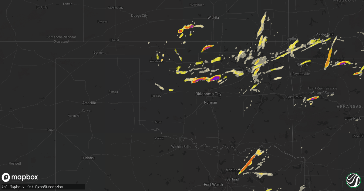
Hail Map in Oklahoma on May 11, 2017
Get this storm
May 11 map
$229
one time, instant access
Download today. No call, no setup
Keep the $229
Bought the map and want the full workflow? Apply the entire $229 to a subscription within 7 days. None of it is wasted.
Every map, not just this one
This buys you this map. Subscription and you get every map we run, in the markets you choose from a few cities to whole states to nationwide. Plus real-time alerts the moment a storm fires.
Contact data
Name, contact info, occupancy, even credit band for addresses in the footprint. You go from where it hit to who to call.
Become the source they trust
Unlimited branding weather history reports on demand. You already have the documented answer ready for the property owner, and you are the one who showed up with it.
Property data and RoofTrace estimates
Pull up any address you have got, its value and the exact code rules for that jurisdiction, straight from One Click Code. Then RoofTrace estimates the squares, pitch, and roof value, priced the way you price.
Storm reports in Oklahoma
Oklahoma
| Date | Description |
|---|---|
| 05/11/20176:32 PM CDT | A local report indicates 70 MPH wind near 1 N PRYOR |
| 05/11/20175:54 PM CDT | Powerpoles broken... Tree uprooted... Numerous large limbs down in the vicinity of blue starr road and ns 4130 road in the northwest side of claremore. |
| 05/11/20175:30 PM CDT | A local report indicates 1.00 inch wind near 4 SE SPERRY |
| 05/11/20175:11 PM CDT | Brief tornado developed northeast of ramona. Filmed from kotv helicopter. |
| 05/11/20175:08 PM CDT | A local report indicates 1.00 inch wind near SAND SPRINGS |
| 05/11/20175:01 PM CDT | A local report indicates 75 MPH wind near 5 SW SPERRY |
| 05/11/20174:40 PM CDT | A local report indicates 63 MPH wind near 8 ESE FORAKER |
| 05/11/20174:33 PM CDT | Large tree branches down. |
| 05/11/20174:25 PM CDT | A local report indicates 1.75 inch wind near PAWHUSKA |
| 05/11/20174:20 PM CDT | Numerous tree limbs up to 3 inches downed. Several big trees blown down. One home with roof damage. Time estimated via radar. |
| 05/11/20174:20 PM CDT | A local report indicates 1.25 inch wind near PAWHUSKA |
| 05/11/20173:50 PM CDT | Nickle to quarter size hail |
| 05/11/20173:13 PM CDT | Hwy 51 and carsteen creek rd. |
| 05/11/20173:13 PM CDT | Numerous spotters and chasers reported a tornado just southwest of perkins. The specific location is estimated. |
| 05/11/20173:06 PM CDT | A local report indicates 2.50 inch wind near MERIDIAN |
| 05/11/20172:56 PM CDT | A local report indicates 70 MPH wind near COYLE |
| 05/11/20172:56 PM CDT | A local report indicates 4.25 inch wind near COYLE |
| 05/11/20172:56 PM CDT | University police |
| 05/11/20172:53 PM CDT | A local report indicates 2.75 inch wind near 1 E LANGSTON |
| 05/11/20172:51 PM CDT | A local report indicates 2.75 inch wind near LANGSTON |
| 05/11/20172:50 PM CDT | A local report indicates 1.75 inch wind near 1 E LANGSTON |
| 05/11/20172:45 PM CDT | A local report indicates 2.00 inch wind near 1 WNW LANGSTON |
| 05/11/20172:40 PM CDT | I35 and and hwy 105 |
| 05/11/20172:38 PM CDT | A local report indicates 1.50 inch wind near 1 E GUTHRIE |
| 05/11/20172:30 PM CDT | A local report indicates 1.00 inch wind near OWASSO |
| 05/11/20172:27 PM CDT | Preliminary nws damage assessment indicates ef1 damage with wind speeds of 100-110 mph. Numerous trees downed/snapped. |
| 05/11/20172:25 PM CDT | A local report indicates 1.00 inch wind near CRESCENT |
| 05/11/20172:25 PM CDT | A local report indicates 76 MPH wind near 4 SSE MARSHALL |
| 05/11/20172:15 PM CDT | Nickel and quarter hail |
| 05/11/20172:10 PM CDT | A local report indicates 1.75 inch wind near MOORELAND |
| 05/11/20172:09 PM CDT | Hail caused quite a bit of damage to the car of the oologah police chief. |
| 05/11/20172:05 PM CDT | Numerous photos of funnels or tornadoes. Photos of damage to trees...some buildings....and fences. Also radar indications of a tornado touchdown. |
| 05/11/20172:01 PM CDT | West side of enid |
| 05/11/20172:00 PM CDT | Small tree limbs snapped... About 3 inches in diameter. |
| 05/11/20172:00 PM CDT | A local report indicates 1.75 inch wind near 2 S CATOOSA |
| 05/11/20171:56 PM CDT | Nickel to quarter sized hail on the broken arrow expressway at 129th east avenue. |
| 05/11/20171:55 PM CDT | Pea to quarter size hail. Hailed for about 10 minutes. Accumulated on the ground. |
| 05/11/20171:48 PM CDT | Tennis ball size hail east side of kingfisher. |
| 05/11/20179:05 AM CDT | A local report indicates 1.00 inch wind near 10 W ANDERSON |
| 05/11/20178:45 AM CDT | Mostly pea to dime covering the ground |
| 05/11/20177:32 AM CDT | A local report indicates 1.25 inch wind near 1 N CLAREMORE |
| 05/10/20177:00 PM CDT | A local report indicates 1.00 inch wind near KETCHUM |
All States Impacted by Hail Map on May 11, 2017
Cities Impacted by Hail Map on May 11, 2017
- Aurora, MO
- Spencer, VA
- Patrick Springs, VA
- Meadows Of Dan, VA
- Stuart, VA
- Perkins, OK
- Coyle, OK
- Guthrie, OK
- McKenzie, TN
- Kingfisher, OK
- Hennessey, OK
- West Plains, MO
- Calico Rock, AR
- Blue Ridge, TX
- Celeste, TX
- Leonard, TX
- Alpena, AR
- Harrison, AR
- Omaha, AR
- Claremore, OK
- West Liberty, KY
- Collinsville, OK
- Oologah, OK
- Austin, TX
- Locust Grove, AR
- Mountain Home, AR
- Lakeview, AR
- Bull Shoals, AR
- Peel, AR
- Yellville, AR
- Verona, MO
- Crane, MO
- Karnack, TX
- Chelsea, OK
- Coweta, OK
- Bison, OK
- Waukomis, OK
- Douglas, OK
- Ames, OK
- Ava, MO
- Seymour, MO
- Tahlequah, OK
- Magazine, AR
- Medicine Lodge, KS
- Alto, TX
- Grapeland, TX
- Pawhuska, OK
- Saint Paul, KS
- Erie, KS
- Medford, OK
- Deer Creek, OK
- Mooringsport, LA
- Jefferson, TX
- Marshall, TX
- Vivian, LA
- Honey Grove, TX
- Forsyth, MO
- Rogers, AR
- Ellington, MO
- Lake City, AR
- Kinder, LA
- Portageville, MO
- Troup, TX
- Jacksonville, TX
- Henderson, TX
- Bullard, TX
- Laneville, TX
- Greenville, TX
- Farmersville, TX
- Mooreland, OK
- Thorndale, TX
- Ripley, TN
- Winnsboro, TX
- Fort Supply, OK
- Buffalo, OK
- Cave City, AR
- Batesville, AR
- Ridgeway, VA
- Mulhall, OK
- Okeene, OK
- Seiling, OK
- Fairview, OK
- Southard, OK
- Longdale, OK
- Canton, OK
- Crescent, OK
- Omega, OK
- Nacogdoches, TX
- Eureka Springs, AR
- Garfield, AR
- Bentonville, AR
- Independence, KS
- Cherryvale, KS
- Altoona, KS
- Thayer, KS
- Benedict, KS
- Humboldt, KS
- Chanute, KS
- Neodesha, KS
- Raleigh, NC
- Hulbert, OK
- Neosho, MO
- Goodman, MO
- Pomona, MO
- Calvert, TX
- Marionville, MO
- Billings, MO
- Morris, OK
- Okmulgee, OK
- Wynona, OK
- Cabool, MO
- Houston, MO
- Tryon, OK
- Agra, OK
- Martinsville, VA
- Nardin, OK
- Bruner, MO
- Colcord, OK
- Kansas, OK
- Rose, OK
- Booneville, AR
- Como, TX
- Brashear, TX
- Sulphur Springs, TX
- Pickton, TX
- Cumby, TX
- Ratcliff, AR
- Paris, AR
- Ozark, AR
- Gatewood, MO
- Summersville, MO
- Eunice, MO
- Yukon, MO
- Elk Horn, KY
- Bradfordsville, KY
- Liberty, KY
- Jonesboro, AR
- Gladewater, TX
- Big Sandy, TX
- Winona, TX
- Oakland, AR
- Knightdale, NC
- Owasso, OK
- Catoosa, OK
- Tulsa, OK
- Greenwood, AR
- Hackett, AR
- Mabank, TX
- Kirbyville, MO
- Powersite, MO
- Hollister, MO
- Taneyville, MO
- Leedey, OK
- Clinton, OK
- Hammon, OK
- Butler, OK
- Subiaco, AR
- Scranton, AR
- Branch, AR
- Wendell, NC
- Clayton, NC
- Wellston, OK
- Carney, OK
- Salem, AR
- Oxford, AR
- Coffeyville, KS
- S Coffeyville, OK
- Edna, KS
- Lenapah, OK
- Canton, TX
- Pleasant Shade, TN
- Sharon, KS
- Delaware, OK
- Vinita, OK
- Buffalo, TX
- Centerville, TX
- Oakwood, TX
- Ochelata, OK
- Skiatook, OK
- Ramona, OK
- Barnsdall, OK
- Perry, OK
- Paris, TX
- Stark City, MO
- Pierce City, MO
- Braman, OK
- Blackwell, OK
- Mount Vernon, TX
- Sandy Ridge, NC
- Fordland, MO
- Billings, OK
- Thornton, TX
- Hector, AR
- Kiowa, KS
- Cotter, AR
- Gassville, AR
- Flippin, AR
- Midway, AR
- Weatherford, OK
- Arapaho, OK
- Enid, OK
- Concord, AR
- Trumann, AR
- Marshall, OK
- Campbell, TX
- Anthony, KS
- Attica, KS
- Gates, TN
- Alamo, TN
- Friendship, TN
- Halls, TN
- Afton, OK
- Wyandotte, OK
- Fairland, OK
- Portland, TN
- Eden, NC
- Axton, VA
- Ruffin, NC
- Oldfield, MO
- Sparta, MO
- Ponca City, OK
- Lockesburg, AR
- Horseshoe Bend, AR
- Ash Flat, AR
- Evening Shade, AR
- Smithville, AR
- Poughkeepsie, AR
- Sidney, AR
- Hardy, AR
- Sumner, TX
- Brookston, TX
- Zenda, KS
- Nashville, KS
- Mammoth Spring, AR
- Walnut Shade, MO
- Yale, OK
- Jennings, OK
- Mannford, OK
- Broken Arrow, OK
- Elmwood, TN
- Carthage, TN
- Spivey, KS
- Watonga, OK
- Brockwell, AR
- Melbourne, AR
- Wideman, AR
- Fairmont, OK
- Cooper, TX
- Caldwell, TX
- Locust Grove, OK
- Inola, OK
- Chouteau, OK
- Kirbyville, TX
- Rogersville, MO
- Springfield, MO
- Mountain View, AR
- Wolfe City, TX
- Ladonia, TX
- Monett, MO
- Ravenden, AR
- Redbird, OK
- Porter, OK
- Cushing, OK
- Okemah, OK
- Harper, KS
- Burlington, OK
- Bethpage, TN
- Oswego, KS
- Jennings, LA
- Solo, MO
- Desha, AR
- Mount Pleasant, AR
- Fairfax, OK
- Dell, AR
- Blytheville, AR
- Cameron, TX
- Franklin, TX
- Bremond, TX
- Clever, MO
- Glasgow, KY
- Eighty Eight, KY
- Gilmer, TX
- Halifax, VA
- Crystal Hill, VA
- Scottsburg, VA
- Nathalie, VA
- Leona, TX
- Rose Hill, VA
- Springfield, KY
- Woodward, OK
- Dover, AR
- Grove, OK
- Jay, OK
- Liberty, KS
- Bixby, OK
- Marland, OK
- Red Rock, OK
- Caddo Mills, TX
- Arthur City, TX
- Frankston, TX
- Chester, OK
- Cushing, TX
- Round Rock, TX
- Pflugerville, TX
- Alpha, KY
- Albany, KY
- Mount Vernon, MO
- Scroggins, TX
- Yantis, TX
- Saltillo, TX
- Emory, TX
- Dover, OK
- Stillwater, OK
- Meridian, OK
- Lexington, TX
- Rockdale, TX
- Garber, OK
- Cross Plains, TN
- White House, TN
- Gallatin, TN
- Cottontown, TN
- Kosse, TX
- Sapulpa, OK
- Sand Springs, OK
- Drumright, OK
- Bristow, OK
- Mount Enterprise, TX
- Mounds, OK
- Seneca, MO
- Thayer, MO
- Petty, TX
- Windom, TX
- Nevada, TX
- Manila, AR
- Granby, MO
- Stella, MO
- Anderson, MO
- Orlando, OK
- Lamar, OK
- Saint Catharine, KY
- Gravel Switch, KY
- Parksville, KY
- Lebanon, KY
- Danville, KY
- Perryville, KY
- Ozark, MO
- Union City, TN
- Troy, TN
- Nixa, MO
- Prescott, AR
- Central City, KY
- Etowah, AR
- Kingman, KS
- Diamond, MO
- Welch, OK
- Castalian Springs, TN
- Douglass, TX
- Hagerhill, KY
- Carmen, OK
- Aline, OK
- Tiptonville, TN
- Jewett, TX
- Marquez, TX
- Groesbeck, TX
- Pikeville, KY
- Wann, OK
- Waldron, KS
- Pawnee, OK
- Cascade, VA
- Reidsville, NC
- Fieldale, VA
- Adair, OK
- Palestine, TX
- Larue, TX
- Nespelem, WA
- Riddleton, TN
- Scott, AR
- Little Rock, AR
- Stanford, KY
- Bardstown, KY
- Junction City, KY
- Boston, KY
- Loretto, KY
- New Haven, KY
- Lebanon Junction, KY
- Stewart, TN
- Tennessee Ridge, TN
- Lead Hill, AR
- Doniphan, MO
- Hawkins, TX
- Mineola, TX
- Lindale, TX
- Bowling Green, KY
- Moody, TX
- Temple, TX
- Blossom, TX
- Mansfield, TN
- Campton, KY
- Beattyville, KY
- Oakland, KY
- Smiths Grove, KY
- Ralston, OK
- Stokes, NC
- Washington, NC
- Greenville, NC
- Shepherd, TX
- Livingston, TX
- Henning, TN
- Maramec, OK
- Ripley, OK
- Terlton, OK
- Garrison, MO
- Chadwick, MO
- Redford, MO
- Fred, TX
- Freedom, OK
- Alva, OK
- Hartsville, TN
- Monroe, TN
- Burkesville, KY
- Pineville, MO
- Noel, MO
- Lanagan, MO
- Commerce, TX
- Donie, TX
- Teague, TX
- Thrall, TX
- Taylor, TX
- Castle, OK
- Rosebud, TX
- Mayfield, KY
- Hutto, TX
- Bonham, TX
- Brownsville, TN
- Marlin, TX
- Lavon, TX
- Powderly, TX
- Alton, MO
- Newkirk, OK
- Telephone, TX
- Normangee, TX
- Dodd City, TX
- Dewey, OK
- Bartlesville, OK
- Covington, OK
- Hitchcock, OK
- Park City, KY
- Boynton, OK
- Council Hill, OK
- Simmesport, LA
- Lettsworth, LA
- Moreauville, LA
- Sheridan, AR
- Hominy, OK
- Kissee Mills, MO
- Eminence, MO
- Watson, OK
- Hilger, MT
- Charleston, AR
- Crockett, TX
- Norwich, KS
- Fairfield, TX
- Kountze, TX
- Camp, AR
- Townsend, MT
- Erin, TN
- Timpson, TX
- Dacoma, OK
- Amorita, OK
- Altamont, KS
- Nowata, OK
- Mound Valley, KS
- Sharon, OK
- Mcalester, OK
- Burlington, TX
- Elkhart, TX
- Milton, KS
- Kennard, TX
- Columbus, KS
- McCune, KS
- Drummond, OK
- Rusk, TX
- Hanna, OK
- Warren, TX
- Frenchburg, KY
- Wellington, KY
- Athens, TX
- Montalba, TX
- Tiff City, MO
- Ketchum, OK
- Galena, MO
- Pattonville, TX
- Henryetta, OK
- Edgewood, TX
- Rocky Hill, KY
- Madisonville, TX
- North Zulch, TX
- Big Sandy, TN
- Elk Creek, MO
- Coupland, TX
- Big Cabin, OK
- Meno, OK
- Fairview, MO
- Twin Oaks, OK
- Springville, TN
- Paris, TN
- Granville, TN
- Gainesboro, TN
- Pryor, OK
- Kerens, TX
- Rocky Comfort, MO
- Purdy, MO
- Exeter, MO
- Carthage, MO
- Wheaton, MO
- Eustace, TX
- Haskell, OK
- Talala, OK
- Lake Creek, TX
- Elizabeth, AR
- Norfork, AR
- Dolph, AR
- Proctor, OK
- Isabella, OK
- Conway Springs, KS
- Henderson, AR
- Bradleyville, MO
- Rueter, MO
- Chilton, TX
- Buna, TX
- Call, TX
- Silsbee, TX
- Highlandville, MO
- Chandler, OK
- Dyersburg, TN
- Church Point, LA
- Sunset, LA
- Lafayette, TN
- Calvin, OK
- Black Oak, AR
- Caraway, AR
- Monette, AR
- Cedarcreek, MO
- Branson, MO
- Elgin, TX
- Salyersville, KY
- Ezel, KY
- Whitleyville, TN
- Staffordsville, KY
- Pelham, NC
- Cashion, OK
- Cleo Springs, OK
- Republic, MO
- Brookland, AR


