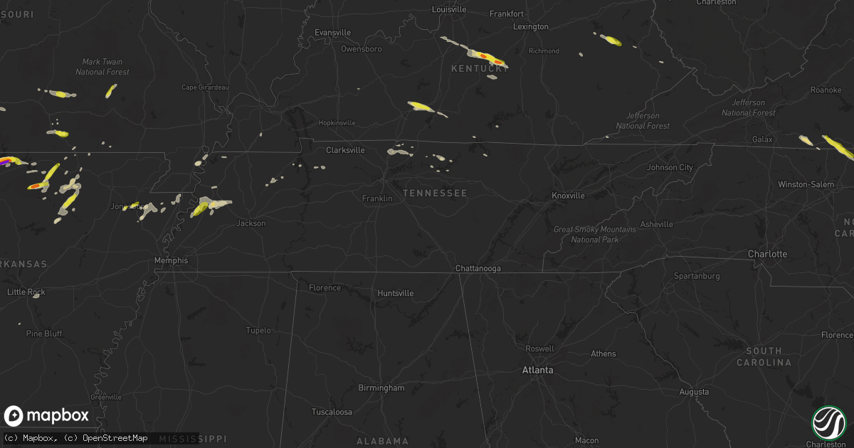
Hail Map in Tennessee on May 11, 2017
Get this storm
May 11 map
$229
one time, instant access
Download today. No call, no setup
Keep the $229
Bought the map and want the full workflow? Apply the entire $229 to a subscription within 7 days. None of it is wasted.
Every map, not just this one
This buys you this map. Subscription and you get every map we run, in the markets you choose from a few cities to whole states to nationwide. Plus real-time alerts the moment a storm fires.
Contact data
Name, contact info, occupancy, even credit band for addresses in the footprint. You go from where it hit to who to call.
Become the source they trust
Unlimited branding weather history reports on demand. You already have the documented answer ready for the property owner, and you are the one who showed up with it.
Property data and RoofTrace estimates
Pull up any address you have got, its value and the exact code rules for that jurisdiction, straight from One Click Code. Then RoofTrace estimates the squares, pitch, and roof value, priced the way you price.
Storm reports in Tennessee
Tennessee
| Date | Description |
|---|---|
| 05/10/20178:03 PM CDT | Quarter size hail at intersection of highways 88 and 209 in gates. |
| 05/10/20178:03 PM CDT | Multiple power outages around lafollette according to lafollette utilities. Time estimated by radar. |
| 05/10/20177:13 PM CDT | A large tree is down on craig road off highway 19 west. Time is radar estimated. |
All States Impacted by Hail Map on May 11, 2017
Cities Impacted by Hail Map on May 11, 2017
- Aurora, MO
- Spencer, VA
- Patrick Springs, VA
- Meadows Of Dan, VA
- Stuart, VA
- Perkins, OK
- Coyle, OK
- Guthrie, OK
- McKenzie, TN
- Kingfisher, OK
- Hennessey, OK
- West Plains, MO
- Calico Rock, AR
- Blue Ridge, TX
- Celeste, TX
- Leonard, TX
- Alpena, AR
- Harrison, AR
- Omaha, AR
- Claremore, OK
- West Liberty, KY
- Collinsville, OK
- Oologah, OK
- Austin, TX
- Locust Grove, AR
- Mountain Home, AR
- Lakeview, AR
- Bull Shoals, AR
- Peel, AR
- Yellville, AR
- Verona, MO
- Crane, MO
- Karnack, TX
- Chelsea, OK
- Coweta, OK
- Bison, OK
- Waukomis, OK
- Douglas, OK
- Ames, OK
- Ava, MO
- Seymour, MO
- Tahlequah, OK
- Magazine, AR
- Medicine Lodge, KS
- Alto, TX
- Grapeland, TX
- Pawhuska, OK
- Saint Paul, KS
- Erie, KS
- Medford, OK
- Deer Creek, OK
- Mooringsport, LA
- Jefferson, TX
- Marshall, TX
- Vivian, LA
- Honey Grove, TX
- Forsyth, MO
- Rogers, AR
- Ellington, MO
- Lake City, AR
- Kinder, LA
- Portageville, MO
- Troup, TX
- Jacksonville, TX
- Henderson, TX
- Bullard, TX
- Laneville, TX
- Greenville, TX
- Farmersville, TX
- Mooreland, OK
- Thorndale, TX
- Ripley, TN
- Winnsboro, TX
- Fort Supply, OK
- Buffalo, OK
- Cave City, AR
- Batesville, AR
- Ridgeway, VA
- Mulhall, OK
- Okeene, OK
- Seiling, OK
- Fairview, OK
- Southard, OK
- Longdale, OK
- Canton, OK
- Crescent, OK
- Omega, OK
- Nacogdoches, TX
- Eureka Springs, AR
- Garfield, AR
- Bentonville, AR
- Independence, KS
- Cherryvale, KS
- Altoona, KS
- Thayer, KS
- Benedict, KS
- Humboldt, KS
- Chanute, KS
- Neodesha, KS
- Raleigh, NC
- Hulbert, OK
- Neosho, MO
- Goodman, MO
- Pomona, MO
- Calvert, TX
- Marionville, MO
- Billings, MO
- Morris, OK
- Okmulgee, OK
- Wynona, OK
- Cabool, MO
- Houston, MO
- Tryon, OK
- Agra, OK
- Martinsville, VA
- Nardin, OK
- Bruner, MO
- Colcord, OK
- Kansas, OK
- Rose, OK
- Booneville, AR
- Como, TX
- Brashear, TX
- Sulphur Springs, TX
- Pickton, TX
- Cumby, TX
- Ratcliff, AR
- Paris, AR
- Ozark, AR
- Gatewood, MO
- Summersville, MO
- Eunice, MO
- Yukon, MO
- Elk Horn, KY
- Bradfordsville, KY
- Liberty, KY
- Jonesboro, AR
- Gladewater, TX
- Big Sandy, TX
- Winona, TX
- Oakland, AR
- Knightdale, NC
- Owasso, OK
- Catoosa, OK
- Tulsa, OK
- Greenwood, AR
- Hackett, AR
- Mabank, TX
- Kirbyville, MO
- Powersite, MO
- Hollister, MO
- Taneyville, MO
- Leedey, OK
- Clinton, OK
- Hammon, OK
- Butler, OK
- Subiaco, AR
- Scranton, AR
- Branch, AR
- Wendell, NC
- Clayton, NC
- Wellston, OK
- Carney, OK
- Salem, AR
- Oxford, AR
- Coffeyville, KS
- S Coffeyville, OK
- Edna, KS
- Lenapah, OK
- Canton, TX
- Pleasant Shade, TN
- Sharon, KS
- Delaware, OK
- Vinita, OK
- Buffalo, TX
- Centerville, TX
- Oakwood, TX
- Ochelata, OK
- Skiatook, OK
- Ramona, OK
- Barnsdall, OK
- Perry, OK
- Paris, TX
- Stark City, MO
- Pierce City, MO
- Braman, OK
- Blackwell, OK
- Mount Vernon, TX
- Sandy Ridge, NC
- Fordland, MO
- Billings, OK
- Thornton, TX
- Hector, AR
- Kiowa, KS
- Cotter, AR
- Gassville, AR
- Flippin, AR
- Midway, AR
- Weatherford, OK
- Arapaho, OK
- Enid, OK
- Concord, AR
- Trumann, AR
- Marshall, OK
- Campbell, TX
- Anthony, KS
- Attica, KS
- Gates, TN
- Alamo, TN
- Friendship, TN
- Halls, TN
- Afton, OK
- Wyandotte, OK
- Fairland, OK
- Portland, TN
- Eden, NC
- Axton, VA
- Ruffin, NC
- Oldfield, MO
- Sparta, MO
- Ponca City, OK
- Lockesburg, AR
- Horseshoe Bend, AR
- Ash Flat, AR
- Evening Shade, AR
- Smithville, AR
- Poughkeepsie, AR
- Sidney, AR
- Hardy, AR
- Sumner, TX
- Brookston, TX
- Zenda, KS
- Nashville, KS
- Mammoth Spring, AR
- Walnut Shade, MO
- Yale, OK
- Jennings, OK
- Mannford, OK
- Broken Arrow, OK
- Elmwood, TN
- Carthage, TN
- Spivey, KS
- Watonga, OK
- Brockwell, AR
- Melbourne, AR
- Wideman, AR
- Fairmont, OK
- Cooper, TX
- Caldwell, TX
- Locust Grove, OK
- Inola, OK
- Chouteau, OK
- Kirbyville, TX
- Rogersville, MO
- Springfield, MO
- Mountain View, AR
- Wolfe City, TX
- Ladonia, TX
- Monett, MO
- Ravenden, AR
- Redbird, OK
- Porter, OK
- Cushing, OK
- Okemah, OK
- Harper, KS
- Burlington, OK
- Bethpage, TN
- Oswego, KS
- Jennings, LA
- Solo, MO
- Desha, AR
- Mount Pleasant, AR
- Fairfax, OK
- Dell, AR
- Blytheville, AR
- Cameron, TX
- Franklin, TX
- Bremond, TX
- Clever, MO
- Glasgow, KY
- Eighty Eight, KY
- Gilmer, TX
- Halifax, VA
- Crystal Hill, VA
- Scottsburg, VA
- Nathalie, VA
- Leona, TX
- Rose Hill, VA
- Springfield, KY
- Woodward, OK
- Dover, AR
- Grove, OK
- Jay, OK
- Liberty, KS
- Bixby, OK
- Marland, OK
- Red Rock, OK
- Caddo Mills, TX
- Arthur City, TX
- Frankston, TX
- Chester, OK
- Cushing, TX
- Round Rock, TX
- Pflugerville, TX
- Alpha, KY
- Albany, KY
- Mount Vernon, MO
- Scroggins, TX
- Yantis, TX
- Saltillo, TX
- Emory, TX
- Dover, OK
- Stillwater, OK
- Meridian, OK
- Lexington, TX
- Rockdale, TX
- Garber, OK
- Cross Plains, TN
- White House, TN
- Gallatin, TN
- Cottontown, TN
- Kosse, TX
- Sapulpa, OK
- Sand Springs, OK
- Drumright, OK
- Bristow, OK
- Mount Enterprise, TX
- Mounds, OK
- Seneca, MO
- Thayer, MO
- Petty, TX
- Windom, TX
- Nevada, TX
- Manila, AR
- Granby, MO
- Stella, MO
- Anderson, MO
- Orlando, OK
- Lamar, OK
- Saint Catharine, KY
- Gravel Switch, KY
- Parksville, KY
- Lebanon, KY
- Danville, KY
- Perryville, KY
- Ozark, MO
- Union City, TN
- Troy, TN
- Nixa, MO
- Prescott, AR
- Central City, KY
- Etowah, AR
- Kingman, KS
- Diamond, MO
- Welch, OK
- Castalian Springs, TN
- Douglass, TX
- Hagerhill, KY
- Carmen, OK
- Aline, OK
- Tiptonville, TN
- Jewett, TX
- Marquez, TX
- Groesbeck, TX
- Pikeville, KY
- Wann, OK
- Waldron, KS
- Pawnee, OK
- Cascade, VA
- Reidsville, NC
- Fieldale, VA
- Adair, OK
- Palestine, TX
- Larue, TX
- Nespelem, WA
- Riddleton, TN
- Scott, AR
- Little Rock, AR
- Stanford, KY
- Bardstown, KY
- Junction City, KY
- Boston, KY
- Loretto, KY
- New Haven, KY
- Lebanon Junction, KY
- Stewart, TN
- Tennessee Ridge, TN
- Lead Hill, AR
- Doniphan, MO
- Hawkins, TX
- Mineola, TX
- Lindale, TX
- Bowling Green, KY
- Moody, TX
- Temple, TX
- Blossom, TX
- Mansfield, TN
- Campton, KY
- Beattyville, KY
- Oakland, KY
- Smiths Grove, KY
- Ralston, OK
- Stokes, NC
- Washington, NC
- Greenville, NC
- Shepherd, TX
- Livingston, TX
- Henning, TN
- Maramec, OK
- Ripley, OK
- Terlton, OK
- Garrison, MO
- Chadwick, MO
- Redford, MO
- Fred, TX
- Freedom, OK
- Alva, OK
- Hartsville, TN
- Monroe, TN
- Burkesville, KY
- Pineville, MO
- Noel, MO
- Lanagan, MO
- Commerce, TX
- Donie, TX
- Teague, TX
- Thrall, TX
- Taylor, TX
- Castle, OK
- Rosebud, TX
- Mayfield, KY
- Hutto, TX
- Bonham, TX
- Brownsville, TN
- Marlin, TX
- Lavon, TX
- Powderly, TX
- Alton, MO
- Newkirk, OK
- Telephone, TX
- Normangee, TX
- Dodd City, TX
- Dewey, OK
- Bartlesville, OK
- Covington, OK
- Hitchcock, OK
- Park City, KY
- Boynton, OK
- Council Hill, OK
- Simmesport, LA
- Lettsworth, LA
- Moreauville, LA
- Sheridan, AR
- Hominy, OK
- Kissee Mills, MO
- Eminence, MO
- Watson, OK
- Hilger, MT
- Charleston, AR
- Crockett, TX
- Norwich, KS
- Fairfield, TX
- Kountze, TX
- Camp, AR
- Townsend, MT
- Erin, TN
- Timpson, TX
- Dacoma, OK
- Amorita, OK
- Altamont, KS
- Nowata, OK
- Mound Valley, KS
- Sharon, OK
- Mcalester, OK
- Burlington, TX
- Elkhart, TX
- Milton, KS
- Kennard, TX
- Columbus, KS
- McCune, KS
- Drummond, OK
- Rusk, TX
- Hanna, OK
- Warren, TX
- Frenchburg, KY
- Wellington, KY
- Athens, TX
- Montalba, TX
- Tiff City, MO
- Ketchum, OK
- Galena, MO
- Pattonville, TX
- Henryetta, OK
- Edgewood, TX
- Rocky Hill, KY
- Madisonville, TX
- North Zulch, TX
- Big Sandy, TN
- Elk Creek, MO
- Coupland, TX
- Big Cabin, OK
- Meno, OK
- Fairview, MO
- Twin Oaks, OK
- Springville, TN
- Paris, TN
- Granville, TN
- Gainesboro, TN
- Pryor, OK
- Kerens, TX
- Rocky Comfort, MO
- Purdy, MO
- Exeter, MO
- Carthage, MO
- Wheaton, MO
- Eustace, TX
- Haskell, OK
- Talala, OK
- Lake Creek, TX
- Elizabeth, AR
- Norfork, AR
- Dolph, AR
- Proctor, OK
- Isabella, OK
- Conway Springs, KS
- Henderson, AR
- Bradleyville, MO
- Rueter, MO
- Chilton, TX
- Buna, TX
- Call, TX
- Silsbee, TX
- Highlandville, MO
- Chandler, OK
- Dyersburg, TN
- Church Point, LA
- Sunset, LA
- Lafayette, TN
- Calvin, OK
- Black Oak, AR
- Caraway, AR
- Monette, AR
- Cedarcreek, MO
- Branson, MO
- Elgin, TX
- Salyersville, KY
- Ezel, KY
- Whitleyville, TN
- Staffordsville, KY
- Pelham, NC
- Cashion, OK
- Cleo Springs, OK
- Republic, MO
- Brookland, AR


