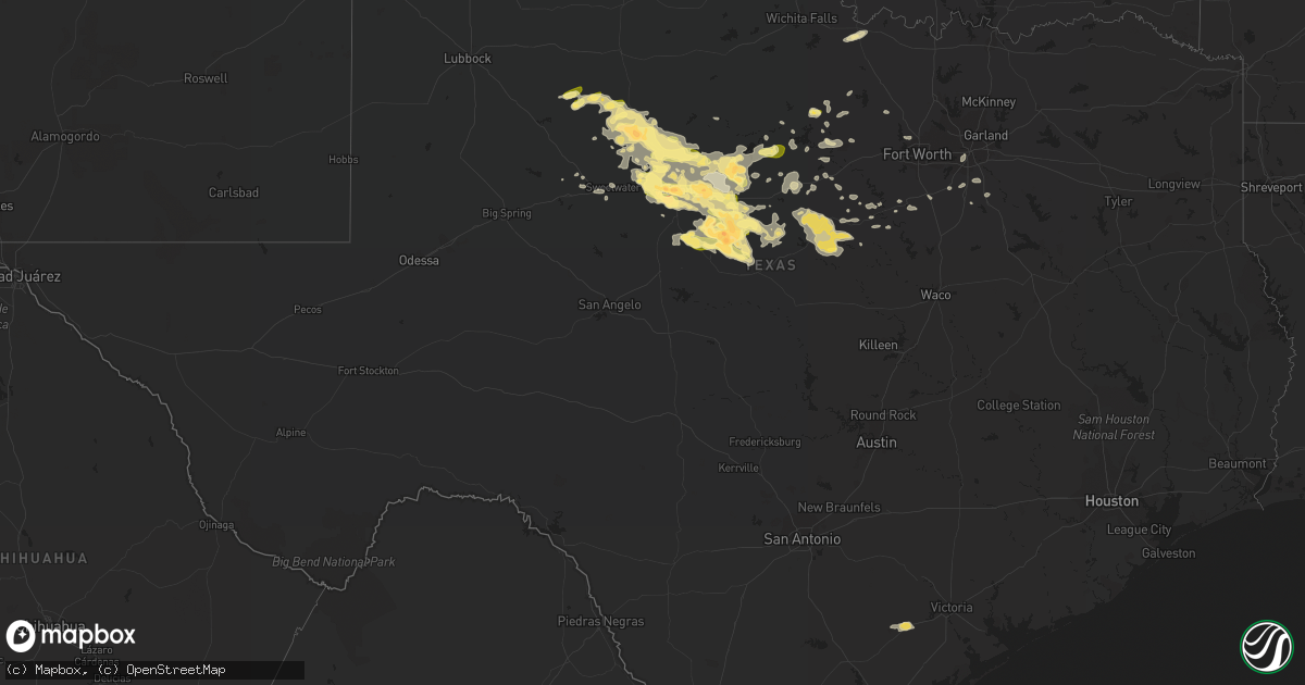
Hail Map in Texas on May 11, 2016
Get this storm
May 11 map
$229
one time, instant access
Download today. No call, no setup
Keep the $229
Bought the map and want the full workflow? Apply the entire $229 to a subscription within 7 days. None of it is wasted.
Every map, not just this one
This buys you this map. Subscription and you get every map we run, in the markets you choose from a few cities to whole states to nationwide. Plus real-time alerts the moment a storm fires.
Contact data
Name, contact info, occupancy, even credit band for addresses in the footprint. You go from where it hit to who to call.
Become the source they trust
Unlimited branding weather history reports on demand. You already have the documented answer ready for the property owner, and you are the one who showed up with it.
Property data and RoofTrace estimates
Pull up any address you have got, its value and the exact code rules for that jurisdiction, straight from One Click Code. Then RoofTrace estimates the squares, pitch, and roof value, priced the way you price.
Storm reports in Texas
Texas
| Date | Description |
|---|---|
| 05/11/20166:49 PM CDT | A local report indicates 75 MPH wind near 12 ESE NUGENT |
| 05/11/20166:25 PM CDT | Several utility polls snapped along county road 295 east of highway 277. |
| 05/11/20166:10 PM CDT | Power lines over the road north of anson. Two horse floats overturned on highway 83 and an rv was flipped north of the intersection of highway 277 and highway 83. |
| 05/11/20166:04 PM CDT | Semi flipped over due to strong straight line winds estimated to be 80 mph or greater. |
| 05/11/20165:57 PM CDT | A local report indicates 65 MPH wind near 1 E ANSON |
| 05/11/20165:55 PM CDT | A local report indicates 60 MPH wind near 7 SW STAMFORD |
| 05/11/20165:40 PM CDT | Numerous limbs down |
| 05/11/20165:29 PM CDT | Viewer reports of golf ball size hail in hamlin. |
| 05/11/20165:10 PM CDT | Very strong winds also. |
| 05/11/20164:20 PM CDT | Pea to quarter size hail reported in jayton by kent county so |
| 05/11/20165:02 AM CDT | 60 mph wind gust reported at abilene airport |
| 05/11/20162:12 AM CDT | A local report indicates 58 MPH wind near 1 N ELECTRA |
| 05/11/20161:39 AM CDT | A local report indicates 63 MPH wind near 4 ENE ODELL |
| 05/11/20161:15 AM CDT | A local report indicates 1.00 inch wind near 6 WNW POTOSI |
| 05/11/20161:12 AM CDT | A local report indicates 1.50 inch wind near VIEW |
| 05/11/20161:00 AM CDT | A local report indicates 1.00 inch wind near 4 E DYESS AFB |
| 05/11/201612:51 AM CDT | At krbc studio |
| 05/11/201612:45 AM CDT | A local report indicates 1.00 inch wind near ABILENE |
| 05/11/201612:45 AM CDT | A local report indicates 1.75 inch wind near CLYDE |
| 05/11/201612:30 AM CDT | 16 power poles down on hwy 62 east of hwy 83. Time estimated from radar. |
| 05/11/201612:17 AM CDT | A local report indicates 1.75 inch wind near 1 E DYESS AFB |
| 05/11/201612:10 AM CDT | N 14th and willis |
| 05/11/201612:09 AM CDT | A local report indicates 1.00 inch wind near 4 SW ABILENE |
| 05/10/201611:42 PM CDT | A local report indicates 1.00 inch wind near LELIA LAKE |
| 05/10/201611:37 PM CDT | A local report indicates 1.00 inch wind near CLARENDON |
| 05/10/201611:25 PM CDT | A local report indicates 60 MPH wind near 2 WSW CLARENDON |
| 05/10/201610:47 PM CDT | A local report indicates 70 MPH wind near CLAUDE |
| 05/10/201610:40 PM CDT | A local report indicates 1.00 inch wind near 8 W CLAUDE |
| 05/10/201610:30 PM CDT | A local report indicates 1.00 inch wind near WASHBURN |
| 05/10/201610:30 PM CDT | A local report indicates 60 MPH wind near 3 NNW EDGECLIFF |
| 05/10/201610:20 PM CDT | A local report indicates 1.00 inch wind near 4 N AMARILLO |
| 05/10/201610:18 PM CDT | A local report indicates 1.00 inch wind near 7 ENE AMARILLO |
| 05/10/201610:17 PM CDT | A local report indicates 76 MPH wind near 6 ENE AMARILLO |
| 05/10/201610:13 PM CDT | A local report indicates 61 MPH wind near 9 NNE AMARILLO |
| 05/10/201610:12 PM CDT | A local report indicates 1.00 inch wind near 5 N AMARILLO |
| 05/10/201610:11 PM CDT | A local report indicates 1.00 inch wind near 4 NE AMARILLO |
| 05/10/201610:10 PM CDT | A local report indicates 1.00 inch wind near 7 N AMARILLO |
| 05/10/201610:09 PM CDT | Hail reported to be larger than quarter size but between quarter and golfball size. |
| 05/10/201610:08 PM CDT | A local report indicates 1.00 inch wind near 4 NW AMARILLO |
| 05/10/201610:07 PM CDT | A local report indicates 1.00 inch wind near 6 NNW AMARILLO |
| 05/10/201610:07 PM CDT | Late report. Quarter size hail at 287 and 335 on the north side of amarillo. |
| 05/10/201610:05 PM CDT | A local report indicates 1.00 inch wind near WHITE DEER |
| 05/10/201610:05 PM CDT | A local report indicates 1.00 inch wind near SKELLYTOWN |
| 05/10/201610:02 PM CDT | A local report indicates 1.00 inch wind near 5 NW AMARILLO |
| 05/10/201610:00 PM CDT | 8 inch diameter tree branch snapped off tree /time estimated/ |
| 05/10/20169:54 PM CDT | A local report indicates 1.00 inch wind near VALLEY DE ORO |
| 05/10/20169:53 PM CDT | A local report indicates 58 MPH wind near 2 N BORGER |
| 05/10/20169:50 PM CDT | A local report indicates 62 MPH wind near 2 N BORGER |
| 05/10/20169:42 PM CDT | Quarter to half dollar size hail ongoing in novice. |
| 05/10/20169:38 PM CDT | A local report indicates 1.00 inch wind near BORGER |
| 05/10/20169:34 PM CDT | A local report indicates 60 MPH wind near MILLSAP |
| 05/10/20169:33 PM CDT | A local report indicates 1.75 inch wind near CROSS PLAINS |
| 05/10/20169:08 PM CDT | Nickel and quarter size hail reported along state road 136 southwest of fritch. |
| 05/10/20169:00 PM CDT | A local report indicates 60 MPH wind near 7 NW ECHO |
| 05/10/20168:35 PM CDT | A local report indicates 1.25 inch wind near 8 ESE OPLIN |
| 05/10/20168:26 PM CDT | A local report indicates 2.75 inch wind near 3 N BURKETT |
| 05/10/20168:17 PM CDT | A local report indicates 1.50 inch wind near 11 ENE CHANNING |
| 05/10/20168:14 PM CDT | A local report indicates 60 MPH wind near BRECKENRIDGE |
| 05/10/20168:14 PM CDT | A local report indicates 1.00 inch wind near 6 E BRECKENRIDGE |
| 05/10/20168:10 PM CDT | A local report indicates 1.50 inch wind near 8 E OPLIN |
| 05/10/20167:55 PM CDT | A local report indicates 60 MPH wind near 1 S BRECKENRIDGE |
| 05/10/20167:34 PM CDT | Quarter size hail at interstate 20 and fm 604. |
| 05/10/20167:24 PM CDT | A local report indicates 60 MPH wind near 4 N MORAN |
| 05/10/20167:24 PM CDT | Half dollar to hen egg size hail falling along state highway 6 north of moran. |
| 05/10/20167:18 PM CDT | A local report indicates 1.00 inch wind near MORAN |
All States Impacted by Hail Map on May 11, 2016
Cities Impacted by Hail Map on May 11, 2016
- Saint Charles, MO
- Wentzville, MO
- Bridgeton, MO
- Saint Louis, MO
- Hazelwood, MO
- Saint Ann, MO
- Lake Saint Louis, MO
- Defiance, MO
- Chesterfield, MO
- Earth City, MO
- Maryland Heights, MO
- O'Fallon, MO
- Saint Peters, MO
- Silex, MO
- Dover, AR
- Lamar, AR
- Summersville, MO
- Mountain View, MO
- Willow Springs, MO
- Nocona, TX
- Freeburg, IL
- New Baden, IL
- Mascoutah, IL
- Marissa, IL
- New Athens, IL
- Addieville, IL
- Crawford, TN
- Ada, OK
- Sasakwa, OK
- Konawa, OK
- Walters, OK
- Geronimo, OK
- Flora, IL
- Sainte Genevieve, MO
- Mineral Point, MO
- Cadet, MO
- Bismarck, MO
- Park Hills, MO
- Farmington, MO
- Valles Mines, MO
- Bonne Terre, MO
- Blackwell, MO
- Richwoods, MO
- Leadwood, MO
- Potosi, MO
- Stonefort, IL
- Dongola, IL
- Buncombe, IL
- Mount Vernon, IN
- Ewing, MO
- La Grange, MO
- Snyder, TX
- Greenwood, AR
- Merkel, TX
- Trent, TX
- Red Bud, IL
- Coalgate, OK
- Centrahoma, OK
- Centralia, IL
- Clyde, TX
- Raymondville, MO
- Lawton, OK
- Eldorado, OK
- Gould, OK
- Poplar Bluff, MO
- Qulin, MO
- Broseley, MO
- Lesterville, MO
- Booneville, KY
- Timewell, IL
- Clayton, IL
- Stratford, OK
- Laddonia, MO
- Centralia, MO
- Bowling Green, MO
- Curryville, MO
- Hallsville, MO
- Mexico, MO
- Columbia, MO
- Rush Hill, MO
- Thompson, MO
- Martinsburg, MO
- Auxvasse, MO
- Benton City, MO
- Vandalia, MO
- Farber, MO
- Wellsville, MO
- Bellevue, TX
- Flat Rock, IL
- Clarendon, TX
- Claude, TX
- Johnsonville, IL
- Keenes, IL
- Cisne, IL
- Fairfield, IL
- Sims, IL
- Golden Gate, IL
- Bluford, IL
- Geff, IL
- Mount Vernon, IL
- Okawville, IL
- Nashville, IL
- Edgewood, IL
- Mason, IL
- Altamont, IL
- Avoca, WI
- Dodgeville, WI
- Spring Green, WI
- Bourbon, MO
- Fredonia, KY
- Marion, KY
- La Grange, KY
- Crestwood, KY
- Tolar, TX
- Granbury, TX
- Glen Rose, TX
- Danville, KY
- Lancaster, KY
- Stanford, KY
- Wilburton, OK
- Red Oak, OK
- Burkett, TX
- Coleman, TX
- Roff, OK
- Roanoke, VA
- Hardy, VA
- Wirtz, VA
- Vinton, VA
- Moneta, VA
- Comanche, OK
- Duncan, OK
- Hawley, TX
- Pacific, MO
- House Springs, MO
- Catawissa, MO
- Vermont, IL
- Astoria, IL
- Ipava, IL
- Waldron, AR
- Mena, AR
- Parks, AR
- Boles, AR
- Cisco, IL
- White Heath, IL
- Argenta, IL
- Monticello, IL
- New London, MO
- Jonesville, LA
- Liberty, IL
- Hull, IL
- Hannibal, MO
- Payson, IL
- Plainville, IL
- Quincy, IL
- Midlothian, TX
- Center, MO
- Perry, MO
- Boss, MO
- Abilene, TX
- Alton, MO
- Houston, MO
- Mount Sterling, IL
- Martin, TN
- Dresden, TN
- Moran, TX
- Dahlgren, IL
- Childress, TX
- Quanah, TX
- Hollis, OK
- Warrenton, MO
- Marthasville, MO
- Vernon, TX
- Loogootee, IN
- Mountain Park, OK
- Highland, WI
- Blair, OK
- Indiahoma, OK
- Snyder, OK
- Roosevelt, OK
- Marlow, OK
- Norris City, IL
- Broughton, IL
- Belleview, MO
- Bixby, MO
- Black, MO
- Ursa, IL
- Cuba, MO
- Ranger, TX
- Tipton, IA
- Tahlequah, OK
- Oaks, OK
- Peggs, OK
- Hulbert, OK
- Rose, OK
- Twin Oaks, OK
- Kinmundy, IL
- Iuka, IL
- West Frankfort, IL
- Benton, IL
- Orient, IL
- Seminole, OK
- Byars, OK
- Allen, OK
- Austin, IN
- Union, MO
- Fort Smith, AR
- Dawson Springs, KY
- Saint Croix, IN
- Collison, IL
- Lone Wolf, OK
- Granite, OK
- Koshkonong, MO
- Augusta, MO
- Robinson, IL
- Bridgeport, IL
- Lawrenceville, IL
- Sumner, IL
- Jacksboro, TX
- Owensville, IN
- Griffin, IN
- Mount Carmel, IL
- Grayville, IL
- Crossville, IL
- Jayton, TX
- Duke, OK
- Davidson, OK
- Lelia Lake, TX
- Memphis, TX
- Dodson, TX
- Wellington, TX
- Vega, TX
- Hedley, TX
- Chillicothe, TX
- Panhandle, TX
- Amarillo, TX
- Odell, TX
- Groom, TX
- Masterson, TX
- Sullivan, MO
- Leasburg, MO
- Steelville, MO
- Saint James, MO
- Bardstown, KY
- Odon, IN
- Corydon, IN
- Pisgah Forest, NC
- Brevard, NC
- Cedar Mountain, NC
- Middletown, MO
- Fulton, KY
- Teutopolis, IL
- Wheeler, IL
- Newman, IL
- Hume, IL
- Harrellsville, NC
- Morrison, MO
- Hermann, MO
- McKenzie, TN
- Henry, TN
- Mangum, OK
- Kopperl, TX
- Hopkinsville, KY
- Frohna, MO
- Farrar, MO
- Perryville, MO
- Carlyle, IL
- Bedford, IN
- Mitchell, IN
- Campbellsburg, IN
- Springfield, KY
- Lebanon, KY
- Cleveland, SC
- Carrier Mills, IL
- Ravenden, AR
- Harrisonburg, LA
- Smithfield, KY
- Goshen, KY
- Fulton, MO
- Chapin, IL
- Jacksonville, IL
- Pauls Valley, OK
- Leslie, MO
- Gerald, MO
- New Haven, MO
- Clinton, IL
- Dewitt, IL
- Shawnee, OK
- Meeker, OK
- Waurika, OK
- Marysville, IN
- Nabb, IN
- Scottsburg, IN
- Herod, IL
- Ozark, AR
- Sylvester, TX
- East Saint Louis, IL
- Granite City, IL
- Dumas, TX
- McLeansboro, IL
- Macedonia, IL
- Springfield, AR
- Damascus, AR
- Cleburne, TX
- Rosman, NC
- Sunset, SC
- Prairie Du Rocher, IL
- Modoc, IL
- Sparta, IL
- Baldwin, IL
- Walsh, IL
- Festus, MO
- Evansville, IL
- French Village, MO
- Fults, IL
- Ellis Grove, IL
- Chester, IL
- Bloomsdale, MO
- Fairland, IN
- Indianapolis, IN
- Fountaintown, IN
- Water Valley, KY
- Russell Springs, KY
- Princeville, IL
- Cache, OK
- Faxon, OK
- Headrick, OK
- Willow, OK
- New Haven, KY
- Gans, OK
- Dublin, TX
- Cross Plains, TX
- Tye, TX
- Dyess Afb, TX
- Tuscola, TX
- Goldsboro, TX
- Albany, TX
- Buffalo Gap, TX
- McCaulley, TX
- Baird, TX
- May, TX
- Avoca, TX
- Brownwood, TX
- Comanche, TX
- Aspermont, TX
- Novice, TX
- Hamlin, TX
- Rising Star, TX
- Roby, TX
- Cisco, TX
- Anson, TX
- Rotan, TX
- Lueders, TX
- Stamford, TX
- Valmeyer, IL
- High Ridge, MO
- Imperial, MO
- Barnhart, MO
- Fenton, MO
- Columbia, IL
- Arnold, MO
- Bryson, TX
- Cookeville, TN
- Caledonia, MO
- Louisville, KY
- Roscoe, TX
- Breckenridge, TX
- Bluff Dale, TX
- Lipan, TX
- Iredell, TX
- Girard, TX
- Westminster, SC
- Lenzburg, IL
- Goliad, TX
- De Leon, TX
- Jacob, IL
- Kinta, OK
- Ninnekah, OK
- Lebanon Junction, KY
- Dewey, IL
- Mahomet, IL
- Palo Pinto, TX
- Santo, TX
- Saint Libory, IL
- Scott Air Force Base, IL
- Trenton, IL
- Breese, IL
- Lebanon, IL
- Aviston, IL
- Highland, IL
- Saint Jacob, IL
- Summerfield, IL
- Frankford, MO
- Neelyville, MO
- Bellflower, MO
- Anna, IL
- Medora, IN
- Norman, IN
- Channing, TX
- Bloomington, IN
- Mingus, TX
- Montgomery City, MO
- New Florence, MO
- Monterey, TN
- Dalhart, TX
- Nara Visa, NM
- Amistad, NM
- Springdale, AR
- Hartford, AR
- Mansfield, AR
- Marion, IL
- Belleville, IL
- Adrian, TX
- Chrisman, IL
- Clinton, IN
- Ina, IL
- Whittington, IL
- Ewing, IL
- Rockville, IN
- Monroe City, MO
- Stephenville, TX
- Camp Point, IL
- Rushville, IL
- De Witt, IA
- Camanche, IA
- Goose Lake, IA
- Clinton, IA
- Harrisburg, IL
- Como, NC
- Cantrall, IL
- Petersburg, IL
- Athens, IL
- Tyner, NC
- Hobbsville, NC
- Collinsville, IL
- O'Fallon, IL
- Caseyville, IL
- Gorham, IL
- Murphysboro, IL
- Graford, TX
- Mineral Wells, TX
- Mount Pulaski, IL
- Strawn, TX
- Smithton, IL
- Purcell, OK
- Goreville, IL
- Princeton, IN
- Fort Branch, IN
- Eunice, MO
- Yukon, MO
- Park Hill, OK
- Vian, OK
- Cookson, OK
- Bunch, OK
- Gore, OK
- Ballwin, MO
- Wildwood, MO
- Wright City, MO
- Troy, MO
- Albion, IL
- Pinckneyville, IL
- Cutler, IL
- Coulterville, IL
- Junction City, KY
- Ellington, MO
- Marietta, SC
- Easley, SC
- Travelers Rest, SC
- Taylors, SC
- Greenville, SC
- Hodgen, OK
- Heavener, OK
- Carlisle, IN
- Beardstown, IL
- Crossville, TN
- Crofton, KY
- Hico, TX
- Union City, TN
- Brocton, IL
- Foster, OK
- Crawfordsville, IN
- Maud, OK
- Du Bois, IL
- Walnut, IL
- Ohio, IL
- Belle Rive, IL
- Plainville, IN
- Washington, IN
- Henryville, IN
- New Washington, IN
- Charlestown, IN
- Hanover, IN
- Underwood, IN
- Otisco, IN
- Bedford, KY
- Bethlehem, IN
- Westport, KY
- Pendleton, KY
- Lexington, IN
- Van Buren, AR
- Spiro, OK
- Arkoma, OK
- Hagarville, AR
- Williamsburg, MO
- Portland, MO
- De Soto, MO
- Sallisaw, OK
- Muldrow, OK
- Bennettsville, SC
- Hartford, KY
- Eureka, MO
- Pauline, SC
- Arcola, IL
- Tuscola, IL
- Carlton, TX
- Maysville, OK
- Lindsay, OK
- Pleasant Plains, IL
- Sherman, IL
- Elkhart, IL
- Williamsville, IL
- Tallula, IL
- Springfield, IL
- Greenview, IL
- Ashland, IL
- Equality, IL
- Junction, IL
- Brownstown, IN
- Calvin, OK
- Doe Run, MO
- Pembroke, KY
- Robertsville, MO
- Carbon, IN
- Rosedale, IN
- Bridgeton, IN
- Oakdale, IL
- Wayne, OK
- Barry, IL
- Hendersonville, NC
- Waterloo, IL
- Rhineland, MO
- Keota, OK
- Annapolis, IL
- Oakland City, IN
- Charleston, AR
- Rule, TX
- Old Glory, TX
- Caddo, TX
- Eastland, TX
- Gorman, TX
- Carbon, TX
- Sidney, TX
- Santa Anna, TX
- Sweetwater, TX
- Winters, TX
- Vallonia, IN
- Paris, MO
- Dale, IL
- Thompsonville, IL
- Doniphan, MO
- Borger, TX
- Kinderhook, IL
- Clarksville, MO
- Sturgeon, MO
- Kingdom City, MO
- Truxton, MO
- Steedman, MO
- Louisiana, MO
- High Hill, MO
- Camden, IL
- Jonesburg, MO
- Ashland, MO
- Eolia, MO
- Hawk Point, MO
- Versailles, IL
- Fairview, IL
- Farmington, IL
- Brussels, IL
- Batchtown, IL
- Winfield, MO
- Old Monroe, MO
- Jonesboro, IL
- Labadie, MO
- Bone Gap, IL
- Morrison, IL
- Uniontown, KY
- Morganfield, KY
- Walnut Hill, IL
- Fisk, MO
- Browns, IL
- Poseyville, IN
- New Harmony, IN
- Springfield, TN
- Orlinda, TN
- Cook Sta, MO
- Paoli, OK
- Waltonville, IL
- Scheller, IL
- Tamaroa, IL
- Ashley, IL
- Mulkeytown, IL
- Royalton, IL
- Elkville, IL
- Effingham, IL
- Booneville, AR
- Solgohachia, AR
- Center Ridge, AR
- Noble, IL
- Ingraham, IL
- Louisville, IL
- Dieterich, IL
- Newton, IL
- West Liberty, IL
- Couch, MO
- New Salem, IL
- Pittsfield, IL
- Cross Plains, TN
- Portland, TN
- Tunnelton, IN
- Cecil, AR
- Elizabeth, AR
- Viola, AR
- Stilwell, OK
- Waynesburg, KY
- Sharon, SC
- Worthington, IN
- Coal City, IN
- Freedom, IN
- Dora, MO
- Vienna, IL
- Ozark, IL
- Carbondale, IL
- Makanda, IL
- Creal Springs, IL
- Carmi, IL
- Harned, KY
- Vandalia, IL
- Campbell Hill, IL
- Bokoshe, OK
- Clarkesville, GA
- Du Quoin, IL
- New Hope, KY
- Alma, AR
- Godley, TX
- Carmel, IN
- Ennis, TX
- Bradley, OK
- Gainesboro, TN
- Palmyra, MO
- Sandgap, KY
- Mountainburg, AR
- Belgrade, MO
- Mount Gilead, NC
- Albemarle, NC
- Desdemona, TX
- Pickens, SC
- Dixon, MO
- Enfield, IL
- Elizabethtown, IL
- Berger, MO
- Patoka, IL
- West Fork, AR
- Fayetteville, AR
- South Fulton, TN
- Elizabethtown, KY
- Cecilia, KY
- Barnhill, IL
- Salem, KY
- Baylis, IL
- Hustonville, KY
- Florissant, MO
- Chester, AR
- Rudy, AR
- East Alton, IL
- Alton, IL
- Graham, TX
- Maquon, IL
- Yates City, IL
- Sedalia, KY
- Wingo, KY
- Mayfield, KY
- New Middletown, IN
- Catlin, IL
- Westville, IL
- Mcalester, OK
- Dallas, TX
- Vergennes, IL
- Ava, IL
- Hurst, IL
- Dowell, IL
- De Soto, IL
- Carterville, IL
- Christopher, IL
- Eldred, IL
- Princeton, IL
- Wyanet, IL
- Sage, AR
- Melbourne, AR
- Franklin, AR
- Chestnut, IL
- Latham, IL
- Red Oak, TX
- Waxahachie, TX
- Manns Harbor, NC
- Avon, IN
- Brownsburg, IN
- Patterson, MO
- Davisville, MO
- Lonedell, MO
- Saint Mary, MO
- Crystal City, MO
- Nashville, NC
- Rocky Mount, NC
- Jasonville, IN
- Natural Dam, AR
- Greenbrier, AR
- Birch Tree, MO
- Woodlawn, IL
- Sandoval, IL
- Richview, IL
- Irvington, IL
- Dix, IL
- Horseshoe Bend, AR
- Gordon, TX
- White Deer, TX
- Maroa, IL
- Cleveland, GA
- Springerton, IL
- Morgantown, KY
- Shelbyville, MO
- Welling, OK
- Vincent, KY
- Wayne City, IL
- Mount Erie, IL
- West Salem, IL
- Ellery, IL
- Winslow, AR
- Elkins, AR
- Sullivan, IN
- Noble, OK
- Lexington, OK
- Washington, OK
- Martin, GA
- Eastanollee, GA
- Chambersburg, IL
- Griggsville, IL
- Brownstown, IL
- Pevely, MO
- Hillsboro, MO
- Ogden, IL
- Fithian, IL
- Heltonville, IN
- Shawneetown, IL
- Madisonville, KY
- Kampsville, IL
- Nebo, IL
- Mcloud, OK
- Throckmorton, TX
- Edwardsport, IN
- Oaktown, IN
- Fulton, IL
- Cedarville, AR
- Huntingburg, IN
- Saint Elizabeth, MO
- Brimfield, IL
- Hanna City, IL
- Edwards, IL
- Mount Vernon, KY
- Stuart, OK
- Haubstadt, IN
- Calhoun, GA
- Farmer City, IL
- Mansfield, IL
- Weldon, IL
- De Land, IL
- Farina, IL
- Leavenworth, IN
- Eure, NC
- Chamois, MO
- Pocola, OK
- Cameron, OK
- Peace Valley, MO
- Tecumseh, OK
- Skellytown, TX
- Fritch, TX
- Pampa, TX
- Mclean, TX
- Percy, IL
- Maywood, MO
- Taylor, MO
- Jackson, KY
- Ferris, TX
- Rockwood, IL
- Crane, IN
- Salem, MO
- Hattieville, AR
- Lavaca, AR
- Poteau, OK
- Hackett, AR
- Tennyson, IN
- Evansville, AR
- Canehill, AR
- Atoka, OK
- Rosebud, MO
- Owensville, MO
- Tupelo, OK
- Earlsboro, OK
- Pettigrew, AR
- Cynthiana, IN
- Francisco, IN
- Texico, IL
- Seymour, IL
- Champaign, IL
- Halifax, NC
- Alma, IL
- Saint Elmo, IL
- Xenia, IL
- Quinton, OK
- Palmer, TX
- Sautee Nacoochee, GA
- Demorest, GA
- Millstadt, IL
- Eldorado, IL
- Saint Clair, MO
- Sesser, IL
- New Burnside, IL
- Irondale, MO
- Saint Albans, MO
- Cedar Hill, MO
- Viburnum, MO
- Ironton, MO
- Middle Brook, MO
- Cambria, IL
- Herrin, IL
- Bunker, MO
- Beaufort, MO
- Omaha, IL
- Cobden, IL
- Herculaneum, MO
- Villa Ridge, MO
- Gray Summit, MO
- Johnston City, IL
- Foristell, MO
- Galatia, IL
- Zeigler, IL
- Logan, IL
- Cherryville, MO
- Washington, MO
- Pittsburg, IL
- Steeleville, IL
- Buckner, IL
- Parkersburg, IL
- Calhoun, IL
- White Plains, KY
- Toccoa, GA
- Lecompton, KS
- New Canton, IL
- Mccurtain, OK
- Branchville, IN
- English, IN
- Leopold, IN
- Bristow, IN
- Birdseye, IN
- Bement, IL
- Mulberry, AR
- Gleason, TN
- Marion, SC
- Sellers, SC
- Holdenville, OK
- Fairmount, IL
- Oakwood, IL
- Ringgold, TX
- Henrietta, TX
- Foley, MO
- Elsberry, MO
- Depauw, IN
- Milltown, IN
- Jamestown, KY
- Carthage, NC
- Vass, NC
- Lowden, IA
- Solsberry, IN
- Prairie Grove, AR
- Eufaula, OK
- Huntington, AR
- Erick, OK
- Munfordville, KY
- Oblong, IL
- Wellston, OK
- Elkton, KY
- Greenville, KY
- Howe, OK
- Perrin, TX
- Montrose, IL
- Marengo, IN
- Ramsey, IN
- Lowell, AR
- Paradise, TX
- Boyd, TX
- Glen Carbon, IL
- Edwardsville, IL
- Roachdale, IN
- Auburn, KY
- Moscow Mills, MO
- Lancaster, SC
- Peachland, NC
- Alvarado, TX
- Troy, IL
- Speer, IL
- Edelstein, IL
- Danville, AR
- Olmstead, KY
- Sharon Grove, KY
- Guthrie, KY
- Russellville, KY
- Lewisburg, KY
- Trenton, KY
- Allensville, KY
- Newalla, OK
- Pittsburg, OK
- Hindsboro, IL
- Atwood, IL
- Keyesport, IL
- Dillon, SC
- Granville, TN
- Whitleyville, TN
- Sidney, IL
- Broadlands, IL
- Homer, IL
- Longview, IL
- Fort Worth, TX
- Manitou, KY
- Wappapello, MO
- Sacramento, KY
- Hartshorn, MO
- Cannelton, IN
- Payneville, KY
- Arcadia, MO
- Hermleigh, TX
- Loraine, TX
- Virginia, IL
- Macomb, IL
- Cannelburg, IN
- Albany, IL
- Prague, OK
- Talihina, OK
- Macomb, OK
- Paris, IL
- Georgetown, IL
- Indianola, IL
- Sidell, IL
- Ridge Farm, IL
- Elmwood, IL
- West Union, IL
- Hutsonville, IL
- West York, IL
- Wewoka, OK
- Holland, IN
- Hodgenville, KY
- Loretto, KY
- Dittmer, MO
- Simpson, IL
- Salem, IL
- Clay City, IL
- La Belle, MO
- Van Buren, MO
- Dustin, OK
- Golconda, IL
- Waverly, KY
- Rio Vista, TX
- Lyons, IN
- Wetumka, OK
- Alexander, IL
- Tell City, IN
- Derby, IN
- Saluda, NC
- Zirconia, NC
- Union Hall, VA
- Nortonville, KY
- Elnora, IN
- Wadesboro, NC
- Norwood, NC
- Ferdinand, IN
- Mount Sidney, VA
- Loveland, OK
- Oak Grove, KY
- Wapello, IA
- Adairville, KY
- Kiowa, OK
- Danville, IN
- Island, KY
- Centertown, KY
- Central City, KY
- Bremen, KY
- Greenville, MO
- Weatherford, TX
- Hidalgo, IL
- Olney, IL
- Ratcliff, AR
- New Palestine, IN
- Greenwood, IN
- Mill Shoals, IL
- Burnt Prairie, IL
- Allerton, IL
- Gravelly, AR
- Harvey, AR
- Whitefield, OK
- Stigler, OK
- Shelbyville, KY
- Spartanburg, SC
- Roebuck, SC
- Moore, SC
- Elizabeth, IN
- Augusta, IL
- Plymouth, IL
- Palestine, IL
- Cerro Gordo, IL
- Milmine, IL
- Canton, IL
- Clarence, IA
- Perryville, KY
- Linn, MO
- Winslow, IN
- Wardville, OK
- Wanette, OK
- Tiskilwa, IL
- Bureau, IL
- Hennepin, IL
- Cleveland, TN
- De Soto, KS
- Bonner Springs, KS
- Linwood, KS
- Olathe, KS
- Eudora, KS
- Paola, KS
- Edgerton, KS
- Spring Hill, KS
- Wellsville, KS
- Rantoul, KS
- Louisburg, KS
- Bucyrus, KS
- Ringling, OK
- Colchester, IL
- Hartley, TX
- Sunray, TX
- Stinnett, TX
- Hartshorne, OK
- Goodview, VA
- Salem, VA


