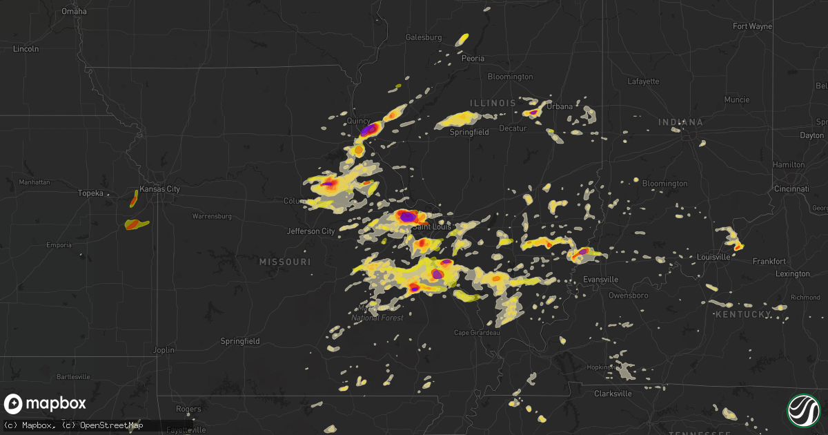
Hail Map on May 11, 2016
Get this storm
May 11 map
$229
one time, instant access
Download today. No call, no setup
Keep the $229
Bought the map and want the full workflow? Apply the entire $229 to a subscription within 7 days. None of it is wasted.
Every map, not just this one
This buys you this map. Subscription and you get every map we run, in the markets you choose from a few cities to whole states to nationwide. Plus real-time alerts the moment a storm fires.
Contact data
Name, contact info, occupancy, even credit band for addresses in the footprint. You go from where it hit to who to call.
Become the source they trust
Unlimited branding weather history reports on demand. You already have the documented answer ready for the property owner, and you are the one who showed up with it.
Property data and RoofTrace estimates
Pull up any address you have got, its value and the exact code rules for that jurisdiction, straight from One Click Code. Then RoofTrace estimates the squares, pitch, and roof value, priced the way you price.
States Impacted by Hail Map on May 11, 2016
Storm reports
Oklahoma
| Date | Description |
|---|---|
| 05/11/20163:53 AM CDT | Multiple small to medium sized trees snapped and uprooted. Power poles snapped. Widespread power outages in town. Relayed to emergency manager by fire department. Time |
| 05/11/20163:38 AM CDT | Nickel to quarter size hail in town. Time estimated via radar. |
| 05/11/20163:32 AM CDT | Barn destroyed and tree blown onto a house just east of junction of highways 1...63...and 2. Time estimated via radar. |
| 05/11/20163:32 AM CDT | Barn destroyed and tree blown onto a house just east of junction of highways 1...63...and 2. Time estimated via radar. Corrected location from previous report. |
| 05/11/20163:32 AM CDT | Barn destroyed and tree blown onto a house just east of junction of highways 1...63...and 2. Time estimated via radar. Corrected location from previous report. |
| 05/11/20162:48 AM CDT | Few large trees down. |
| 05/11/20162:40 AM CDT | Measured by oklahoma mesonet |
| 05/11/20162:36 AM CDT | Baseball sized hail |
| 05/11/20162:32 AM CDT | *** 1 inj *** mobile home heavily damaged resulted in a possible injury |
| 05/11/20162:16 AM CDT | A local report indicates 1.75 inch wind near 3 N FAXON |
| 05/11/20162:15 AM CDT | Quarter sized hail |
| 05/11/20162:10 AM CDT | Quarter hail |
| 05/11/20161:31 AM CDT | Hen egg size hail and windows knocked out at the tom steed lake bait shop |
| 05/11/20161:02 AM CDT | A local report indicates 2.50 inch wind near 2 S GRANITE |
| 05/11/201612:50 AM CDT | A local report indicates 1.00 inch wind near 3 N MANGUM |
| 05/11/201612:45 AM CDT | Quarter sized hail |
| 05/10/201611:55 PM CDT | Trees snapped |
| 05/10/201611:44 PM CDT | Dime to quarter size hail in honey hill. Time estimated by radar. |
| 05/10/201611:35 PM CDT | Major damage to snake creek marina. Time estimated by radar. |
| 05/10/201610:45 PM CDT | A local report indicates 1.50 inch wind near ADDINGTON |
| 05/10/201610:40 PM CDT | Relayed from kswo-tv. |
| 05/10/201610:33 PM CDT | A local report indicates 1.00 inch wind near 4 NNE COMANCHE |
| 05/10/201610:25 PM CDT | Relayed from kswo-tv. |
| 05/10/201610:25 PM CDT | Relayed by kswo-tv. |
| 05/10/201610:25 PM CDT | Relayed by kswo-tv. |
Missouri
| Date | Description |
|---|---|
| 05/11/20166:45 PM CDT | Power pole snapped off. |
| 05/11/20166:45 PM CDT | Several trees and large branches down |
| 05/11/20166:42 PM CDT | Wall cloud with some rotation. Quarter size hail in leadington. |
| 05/11/20166:35 PM CDT | A local report indicates 2.75 inch wind near DESLOGE |
| 05/11/20166:27 PM CDT | Observed in south part of the city. |
| 05/11/20166:26 PM CDT | On highway 19 |
| 05/11/20166:21 PM CDT | Reported by law enforcement at the 911 call center |
| 05/11/20166:20 PM CDT | A local report indicates 1.75 inch wind near LEADINGTON |
| 05/11/20166:20 PM CDT | Several large trees blown down. |
| 05/11/20166:19 PM CDT | A local report indicates 2.50 inch wind near PARK HILLS |
| 05/11/20166:18 PM CDT | A local report indicates 2.50 inch wind near PARK HILLS |
| 05/11/20166:16 PM CDT | Wall cloud with very weak rotation located west of park hills. Golf ball size hail in park hills. |
| 05/11/20166:14 PM CDT | Few trees down |
| 05/11/20166:05 PM CDT | Nickel to quarter size hail via public |
| 05/11/20166:05 PM CDT | A local report indicates 1.25 inch wind near POTOSI |
| 05/11/20166:00 PM CDT | Report relayed by broadcast media. Hailed for 30 minutes from 600 pm to 630 pm. Vehicle damage. |
| 05/11/20165:47 PM CDT | A local report indicates 1.00 inch wind near AUXVASSE |
| 05/11/20165:45 PM CDT | A local report indicates 1.00 inch wind near 3 NW FULTON |
| 05/11/20165:38 PM CDT | A local report indicates 1.75 inch wind near MEXICO |
| 05/11/20165:34 PM CDT | Hail being observed on the west side of town |
| 05/11/20165:30 PM CDT | Hail damage to vehicle. |
| 05/11/20165:28 PM CDT | A local report indicates 1.00 inch wind near ST. MARY |
| 05/11/20165:26 PM CDT | At route nn west of mexico |
| 05/11/20165:20 PM CDT | A local report indicates 1.00 inch wind near CENTRALIA |
| 05/11/20165:14 PM CDT | A local report indicates 1.00 inch wind near PARK HILLS |
| 05/11/20165:14 PM CDT | A local report indicates 1.25 inch wind near 2 N CUBA |
| 05/11/20165:05 PM CDT | Scattered trees down throughout the city and county |
| 05/11/20164:58 PM CDT | A local report indicates 1.75 inch wind near DESLOGE |
| 05/11/20164:55 PM CDT | A local report indicates 1.00 inch wind near STE. GENEVIEVE |
| 05/11/20164:55 PM CDT | Report relayed by broadcast media. Hailed for 30 minutes from 455 pm to 525 pm. Vehicle damage. |
| 05/11/20164:51 PM CDT | A local report indicates 1.75 inch wind near 1 N DESLOGE |
| 05/11/20164:50 PM CDT | A local report indicates 1.75 inch wind near 1 S BONNE TERRE |
| 05/11/20164:45 PM CDT | Few trees down blocking 1 lane of us highway 61 |
| 05/11/20164:45 PM CDT | Trees down |
| 05/11/20164:45 PM CDT | Trees down |
| 05/11/20163:25 PM CDT | A local report indicates 1.00 inch wind near 2 SSE SHIRLEY |
| 05/11/20162:16 PM CDT | A local report indicates 1.25 inch wind near 3 S FESTUS |
| 05/11/20162:10 PM CDT | A local report indicates 1.25 inch wind near 2 S FESTUS |
| 05/11/20161:55 PM CDT | Large tree blown down at spanish lake park...blocking roadway. |
| 05/11/20161:55 PM CDT | Large tree blown onto 3 homes in 6900 block of dale ave. Causing damage. South of forest park. |
| 05/11/20161:55 PM CDT | Observed in crescent mo. |
| 05/11/20161:49 PM CDT | A local report indicates 1.00 inch wind near 1 N DELLWOOD |
| 05/11/20161:45 PM CDT | A local report indicates 1.00 inch wind near HAZELWOOD |
| 05/11/20161:45 PM CDT | A local report indicates 1.75 inch wind near 2 N UNIVERSITY CITY |
| 05/11/20161:45 PM CDT | A local report indicates 1.00 inch wind near OAKVILLE |
| 05/11/20161:45 PM CDT | A local report indicates 1.00 inch wind near PEVELY |
| 05/11/20161:43 PM CDT | In the delmar loop area |
| 05/11/20161:41 PM CDT | Tree down in skinker-debaliviere neighborhood |
| 05/11/20161:41 PM CDT | Hwy 141 at 1-55 |
| 05/11/20161:40 PM CDT | Tree uprooted |
| 05/11/20161:40 PM CDT | Large trees and several power lines blown down. |
| 05/11/20161:40 PM CDT | A local report indicates 1.25 inch wind near MARYLAND HEIGHTS |
| 05/11/20161:39 PM CDT | Tree down in skinker-debaliviere neighborhood. |
| 05/11/20161:39 PM CDT | Hail up to quarters |
| 05/11/20161:38 PM CDT | Tree down in ferguson blocking the road. Time estimated from radar. |
| 05/11/20161:38 PM CDT | A local report indicates 1.00 inch wind near IMPERIAL |
| 05/11/20161:38 PM CDT | Tree damage. Power outage. Time estimated from radar. |
| 05/11/20161:38 PM CDT | A local report indicates 1.00 inch wind near KIMMSWICK |
| 05/11/20161:38 PM CDT | A local report indicates 2.50 inch wind near ARNOLD |
| 05/11/20161:38 PM CDT | Large tree snapped off at ground near intersection of delmar and i-170. |
| 05/11/20161:37 PM CDT | A local report indicates 1.75 inch wind near ARNOLD |
| 05/11/20161:35 PM CDT | Trees and power lines down |
| 05/11/20161:35 PM CDT | Trees and power lines down |
| 05/11/20161:34 PM CDT | Along richardson road in arnold. |
| 05/11/20161:30 PM CDT | Tree down on a house at intersection of st. Henry and st. Sebastian lanes. Another tree blown down on a house at the intersection of ashby road and san carlos lane. |
| 05/11/20161:30 PM CDT | Tree fell onto a car causing major damage. |
| 05/11/20161:30 PM CDT | Tree down on a house. |
| 05/11/20161:27 PM CDT | A local report indicates 1.00 inch wind near CHESTERFIELD |
| 05/11/20161:27 PM CDT | A local report indicates 1.00 inch wind near MARYLAND HEIGHTS |
| 05/11/20161:26 PM CDT | A local report indicates 1.75 inch wind near MARYLAND HEIGHTS |
| 05/11/20161:25 PM CDT | A local report indicates 1.75 inch wind near MARYLAND HEIGHTS |
| 05/11/20161:20 PM CDT | A local report indicates 1.25 inch wind near CHESTERFIELD |
| 05/11/20161:20 PM CDT | Tree down |
| 05/11/20161:20 PM CDT | At the st. Peters line with st. Charles |
| 05/11/20161:20 PM CDT | Tree down |
| 05/11/20161:14 PM CDT | Hwy 94 at hwy 364 |
| 05/11/20161:13 PM CDT | Near exit 225 on i-70. |
| 05/11/20161:13 PM CDT | Highway 370 adn elm st. |
| 05/11/20161:10 PM CDT | A local report indicates 2.00 inch wind near HARVESTER |
| 05/11/20161:09 PM CDT | I-70 and zumbehl |
| 05/11/20161:08 PM CDT | A local report indicates 2.00 inch wind near COTTLEVILLE |
| 05/11/20161:08 PM CDT | Kisker rd at 94 |
| 05/11/20161:06 PM CDT | Near intersection of spencer and willot. |
| 05/11/20161:04 PM CDT | A local report indicates 2.00 inch wind near 2 SW COTTLEVILLE |
| 05/11/20161:04 PM CDT | A local report indicates 2.50 inch wind near ST. PETERS |
| 05/11/20161:03 PM CDT | Measured hail stone...3.5 inches in diameter. |
| 05/11/20161:02 PM CDT | A local report indicates 1.75 inch wind near COTTLEVILLE |
| 05/11/20161:02 PM CDT | On ofallon road near francis howell middle school. |
| 05/11/20161:02 PM CDT | Oak hollow drive near birdie hills road. |
| 05/11/20161:01 PM CDT | A local report indicates 2.50 inch wind near O'FALLON |
| 05/11/20161:01 PM CDT | 120 of 150 cars at dealership sustained busted windows and lots of dents from large hail...some up to baseball size. |
| 05/11/201612:59 PM CDT | From troop c at highway 94 and i-64. |
| 05/11/201612:57 PM CDT | Measured hail stone...4 inches in diameter. |
| 05/11/201612:57 PM CDT | A local report indicates 1.00 inch wind near 2 S BYRNES MILL |
| 05/11/201612:56 PM CDT | A local report indicates 1.00 inch wind near DARDENNE PRAIRIE |
| 05/11/201612:54 PM CDT | A local report indicates 1.00 inch wind near O'FALLON |
| 05/11/201612:50 PM CDT | Flat 1 inch hail |
| 05/11/201612:45 PM CDT | A local report indicates 1.00 inch wind near EUREKA |
| 05/11/201612:37 PM CDT | A local report indicates 1.00 inch wind near DUTZOW |
| 05/11/201611:00 AM CDT | A local report indicates 1.00 inch wind near FARBER |
| 05/11/201610:35 AM CDT | A local report indicates 1.00 inch wind near 2 N AUXVASSE |
| 05/11/201610:35 AM CDT | A local report indicates 1.00 inch wind near 4 S MEXICO |
| 05/11/201610:15 AM CDT | Quarter size hail and small tree limbs blown down...route d east of route dd. |
| 05/11/201610:15 AM CDT | Quarter size hail and small tree limbs blown down...route d east of route dd. |
| 05/10/20169:29 PM CDT | Near the county line. Near intersection of ww and j. |
| 05/10/20169:29 PM CDT | Near the county line. Near intersection of ww and j. |
| 05/10/20169:05 PM CDT | A local report indicates 1.00 inch wind near CRYSTAL CITY |
| 05/10/20169:00 PM CDT | Trailer home lost roof |
| 05/10/20168:57 PM CDT | A local report indicates 1.00 inch wind near 2 S FESTUS |
| 05/10/20168:56 PM CDT | A local report indicates 1.25 inch wind near FESTUS |
| 05/10/20168:56 PM CDT | A local report indicates 1.25 inch wind near 3 S FESTUS |
| 05/10/20168:30 PM CDT | Hailed for 15 minutes. |
| 05/10/20168:17 PM CDT | A local report indicates 1.00 inch wind near 5 SSW ST. CLAIR |
| 05/10/20168:17 PM CDT | A local report indicates 1.00 inch wind near ST. CLAIR |
| 05/10/20168:10 PM CDT | A local report indicates 1.00 inch wind near 2 S BOURBON |
| 05/10/20168:08 PM CDT | A local report indicates 1.50 inch wind near 3 SE BOURBON |
| 05/10/20168:07 PM CDT | Several large tree limbs down |
| 05/10/20168:07 PM CDT | Branches down |
| 05/10/20167:50 PM CDT | Reported in labadie |
| 05/10/20167:48 PM CDT | A local report indicates 1.00 inch wind near 10 N POTOSI |
| 05/10/20167:35 PM CDT | At hawn state park |
| 05/10/20167:25 PM CDT | A local report indicates 1.00 inch wind near UNION |
| 05/10/20167:10 PM CDT | A local report indicates 1.00 inch wind near NEW LONDON |
| 05/10/20167:10 PM CDT | Report relayed by broadcast media. Hailed for 30 minutes. Vehicle damage. |
| 05/10/20167:08 PM CDT | Report from trained spotter relayed by broadcast media |
| 05/10/20167:00 PM CDT | Few trees down on highway u |
| 05/10/20167:00 PM CDT | A local report indicates 1.00 inch wind near HANNIBAL |
Kentucky
| Date | Description |
|---|---|
| 05/11/20167:36 AM CDT | Water reported over the road in olmstead |
| 05/10/201610:45 PM CDT | Trees dwon on highway 587. |
| 05/10/201610:30 PM CDT | Trees down on highway 290. |
| 05/10/20169:56 PM CDT | Tree down on henry clay road and road culvert washed out on hwy 698. |
| 05/10/20169:50 PM CDT | Tree reported down. |
| 05/10/20169:10 PM CDT | A couple trees down reported across the county. |
| 05/10/20168:54 PM CDT | Tree down on maplewood ave in springfield... Ky. |
| 05/10/20168:33 PM CDT | Trees reported down. |
| 05/10/20168:31 PM CDT | Tree limbs down. |
| 05/10/20168:30 PM CDT | A local report indicates 60 MPH wind near 1 SSE SLIGO |
| 05/10/20168:30 PM CDT | Couple of reports of trees down across the county. |
| 05/10/20168:26 PM CDT | Tree down on sunny point road... Hwy 1075... Near sunfish. |
| 05/10/20168:12 PM CDT | Trees and power lines down in the northern part of the county. |
| 05/10/20168:10 PM CDT | A local report indicates 1.00 inch wind near LEBANON JUNCTION |
| 05/10/20168:02 PM CDT | Tree down... Reported on the 2300 block of north rose island road... Prospect... Ky. |
| 05/10/20168:00 PM CDT | Tree down on hwy 54 one mile from short creek. |
| 05/10/20167:56 PM CDT | Tree reported down. |
| 05/10/20167:55 PM CDT | Parts of louisville gardens roof damaged. |
| 05/10/20167:33 PM CDT | Silver maple down on power line. 2 power poles are being replaced. |
| 05/10/20167:21 PM CDT | A local report indicates 1.00 inch wind near SMITHFIELD |
| 05/10/20167:14 PM CDT | A local report indicates 1.75 inch wind near BALLARDSVILLE |
| 05/10/20167:12 PM CDT | A local report indicates 1.00 inch wind near 1 N BALLARDSVILLE |
Illinois
| Date | Description |
|---|---|
| 05/11/20166:24 PM CDT | A local report indicates 1.00 inch wind near DU QUOIN |
| 05/11/20165:23 PM CDT | Wind speed estimate up to 70 mph. |
| 05/11/20165:18 PM CDT | A local report indicates 1.50 inch wind near DU QUOIN |
| 05/11/20165:17 PM CDT | A local report indicates 71 MPH wind near MOUNT CARMEL AIRPORT |
| 05/11/20165:17 PM CDT | Trees blocking the road west side of evansville. Wind gust 71 mph |
| 05/11/20165:15 PM CDT | Quarter to half dollar size hail |
| 05/11/20165:03 PM CDT | A local report indicates 70 MPH wind near BELLAIR |
| 05/11/20165:02 PM CDT | A local report indicates 1.00 inch wind near EVANSVILLE |
| 05/11/20164:57 PM CDT | 65 to 70 mph winds |
| 05/11/20164:55 PM CDT | A local report indicates 60 MPH wind near 3 N HENNING |
| 05/11/20164:45 PM CDT | A local report indicates 1.00 inch wind near 5 S RUMA |
| 05/11/20164:44 PM CDT | A local report indicates 1.00 inch wind near MODOC |
| 05/11/20164:40 PM CDT | Estimated 65 mph winds. Tore off some roof shingles. |
| 05/11/20164:38 PM CDT | Railroad crossing arms broken off. |
| 05/11/20164:30 PM CDT | Power lines blown down. |
| 05/11/20164:25 PM CDT | Trees bent and hanging over the road at route 37. |
| 05/11/20164:25 PM CDT | Trees and power lines down along the mason ebberle road. |
| 05/11/20164:18 PM CDT | Two trees down on roads. |
| 05/11/20164:15 PM CDT | Small tree limbs down |
| 05/11/20164:12 PM CDT | A local report indicates 1.75 inch wind near 1 E GRAYVILLE |
| 05/11/20163:45 PM CDT | Objects blown off porches |
| 05/11/20163:45 PM CDT | Few trees and limbs down |
| 05/11/20163:42 PM CDT | A local report indicates 1.75 inch wind near FAIRFIELD |
| 05/11/20163:38 PM CDT | A local report indicates 1.00 inch wind near RED BUD |
| 05/11/20163:34 PM CDT | A local report indicates 2.00 inch wind near RED BUD |
| 05/11/20163:32 PM CDT | A local report indicates 1.50 inch wind near FAIRFIELD |
| 05/11/20163:30 PM CDT | A local report indicates 1.25 inch wind near RED BUD |
| 05/11/20163:29 PM CDT | Quarter size hail. |
| 05/11/20163:29 PM CDT | Quarter size hail at the airport. |
| 05/11/20163:26 PM CDT | A local report indicates 1.00 inch wind near FAIRFIELD |
| 05/11/20163:24 PM CDT | A local report indicates 62 MPH wind near MONTICELLO |
| 05/11/20163:21 PM CDT | Hail up to egg size reported by trained spotter through sheriff office. |
| 05/11/20163:15 PM CDT | A local report indicates 1.50 inch wind near WAYNE CITY |
| 05/11/20163:15 PM CDT | Tree uprooted. Large branches down. |
| 05/11/20163:13 PM CDT | A local report indicates 66 MPH wind near 1 NW MONTICELLO |
| 05/11/20163:08 PM CDT | Trees down in carlyle. One tree knocked down a power pole near us 50 and il 127. |
| 05/11/20163:05 PM CDT | Trees down |
| 05/11/20163:05 PM CDT | Few trees and limbs down |
| 05/11/20163:00 PM CDT | Numerous trees and powerlines down. Ponding on roads as well |
| 05/11/20163:00 PM CDT | A local report indicates 1.00 inch wind near 2 N BREESE |
| 05/11/20162:56 PM CDT | A few 1.5 ft diameter trees down. Shingles blown off of a few roofs. |
| 05/11/20162:55 PM CDT | Numerous trees and power lines down |
| 05/11/20162:55 PM CDT | Trees and power lines down |
| 05/11/20162:55 PM CDT | Power lines down |
| 05/11/20162:50 PM CDT | A local report indicates 1.00 inch wind near FULTS |
| 05/11/20162:50 PM CDT | 12 inch diameter tree down. |
| 05/11/20162:48 PM CDT | A local report indicates 1.00 inch wind near SHILOH |
| 05/11/20162:48 PM CDT | Power lines down. |
| 05/11/20162:45 PM CDT | Numerous trees down...top part of a silo blown off...power lines down |
| 05/11/20162:40 PM CDT | Large tree down in summerfield. Photo from twitter. Time consistent with radar. |
| 05/11/20162:40 PM CDT | A local report indicates 76 MPH wind near 3 S NEW BADEN |
| 05/11/20162:39 PM CDT | A local report indicates 1.00 inch wind near 2 SSW MAEYSTOWN |
| 05/11/20162:39 PM CDT | A local report indicates 1.00 inch wind near MAEYSTOWN |
| 05/11/20162:38 PM CDT | Numerous trees down |
| 05/11/20162:35 PM CDT | A local report indicates 70 MPH wind near NEW BADEN |
| 05/11/20162:35 PM CDT | Trees down. One blocking route 15. |
| 05/11/20162:35 PM CDT | A local report indicates 1.00 inch wind near SHILOH |
| 05/11/20162:24 PM CDT | Estimated wind gusts of 35-40 mph |
| 05/11/20162:15 PM CDT | Large tree limbs blown down. |
| 05/11/20162:14 PM CDT | A local report indicates 1.00 inch wind near MILLSTADT |
| 05/11/20162:10 PM CDT | A local report indicates 1.00 inch wind near NEW ATHENS |
| 05/11/20162:07 PM CDT | Shingles blown off of a house |
| 05/11/20162:00 PM CDT | Several trees and large limbs down |
| 05/11/20161:58 PM CDT | Northern side of town. |
| 05/11/20161:55 PM CDT | A local report indicates 1.00 inch wind near NEW HANDOVER |
| 05/11/20161:50 PM CDT | A local report indicates 1.00 inch wind near NEW HANDOVER |
| 05/11/20161:39 PM CDT | Multiple tree limbs down. One apple tree snapped at the base. Swop report. |
| 05/11/20161:39 PM CDT | Pea size hail for about 5 minutes. Swop report. Measured wind speed corrected. |
| 05/11/20161:33 PM CDT | Several trees down near il route 29 and indian point road. |
| 05/11/20161:30 PM CDT | Seven power poles snapped at cline rd and il route 123. |
| 05/11/20161:28 PM CDT | 0.5 inch hail also reported. |
| 05/10/201611:16 PM CDT | Several large limbs down in southwest side of the city |
| 05/10/201610:05 PM CDT | Hail ranging from one half inch to one inch. Estimated 40-50 mph winds. |
| 05/10/20169:20 PM CDT | Three quarter inch to one inch diameter hail. |
| 05/10/20167:52 PM CDT | From khqa |
| 05/10/20167:50 PM CDT | A local report indicates 2.00 inch wind near KELLERVILLE |
| 05/10/20167:42 PM CDT | A local report indicates 1.00 inch wind near LIBERTY |
| 05/10/20167:37 PM CDT | A local report indicates 1.75 inch wind near PAYSON |
| 05/10/20167:34 PM CDT | A local report indicates 1.00 inch wind near 3 ESE BURTON |
| 05/10/20167:33 PM CDT | A local report indicates 2.75 inch wind near 3 NE PAYSON |
| 05/10/20167:30 PM CDT | A local report indicates 1.75 inch wind near PAYSON |
| 05/10/20167:29 PM CDT | A local report indicates 1.00 inch wind near MARION |
| 05/10/20167:27 PM CDT | From khqa |
| 05/10/20167:25 PM CDT | A local report indicates 2.75 inch wind near PAYSON |
| 05/10/20167:22 PM CDT | A local report indicates 4.50 inch wind near PAYSON |
| 05/10/20167:17 PM CDT | A local report indicates 2.00 inch wind near PAYSON |
| 05/10/20167:12 PM CDT | A local report indicates 4.50 inch wind near PAYSON |
South Carolina
| Date | Description |
|---|---|
| 05/11/20163:45 PM CDT | Dime to quarter sized hail near the intersection of highways 221 and 295. |
| 05/11/20162:35 PM CDT | Hail observed along cleo chapman highway near sunset... Sc. |
| 05/11/20162:19 PM CDT | Observed along oil camp creek rd. |
| 05/11/20162:10 PM CDT | Observed at jones gap state park |
| 05/11/20162:05 PM CDT | Observed at ymca camp greenville |
| 05/11/20162:00 PM CDT | On wednesday afternoon...two periods of hail with the first giving a few quarter sized hailstones and then smaller hail a few minutes later. Some tree limbs blown down |
| 05/11/20161:00 PM CDT | Observed at hwy 123 and jenkins br rd. |
Virginia
| Date | Description |
|---|---|
| 05/11/20164:10 PM CDT | Tree down |
| 05/11/20163:30 PM CDT | Large tree down along finney rd also noted quarter size hail |
| 05/11/20163:12 PM CDT | Tree down on booker t washington hwy |
| 05/11/20163:06 PM CDT | Tree down on edwardsville rd |
| 05/11/20163:06 PM CDT | Tree down on booker t washington hwy |
| 05/11/20163:00 PM CDT | Tree down on coopers cove rd |
| 05/11/20162:50 PM CDT | Twelve inch oak tree knocked over |
| 05/11/20162:43 PM CDT | A local report indicates 1.00 inch wind near 2 NE ROANOKE |
| 05/11/20162:36 PM CDT | Trees down along williamson rd. |
| 05/11/20162:35 PM CDT | Also noted some tree limbs down |
Iowa
| Date | Description |
|---|---|
| 05/10/20167:42 PM CDT | Reported through social media photo |
Texas
| Date | Description |
|---|---|
| 05/11/20166:49 PM CDT | A local report indicates 75 MPH wind near 12 ESE NUGENT |
| 05/11/20166:25 PM CDT | Several utility polls snapped along county road 295 east of highway 277. |
| 05/11/20166:10 PM CDT | Power lines over the road north of anson. Two horse floats overturned on highway 83 and an rv was flipped north of the intersection of highway 277 and highway 83. |
| 05/11/20166:04 PM CDT | Semi flipped over due to strong straight line winds estimated to be 80 mph or greater. |
| 05/11/20165:57 PM CDT | A local report indicates 65 MPH wind near 1 E ANSON |
| 05/11/20165:55 PM CDT | A local report indicates 60 MPH wind near 7 SW STAMFORD |
| 05/11/20165:40 PM CDT | Numerous limbs down |
| 05/11/20165:29 PM CDT | Viewer reports of golf ball size hail in hamlin. |
| 05/11/20165:10 PM CDT | Very strong winds also. |
| 05/11/20164:20 PM CDT | Pea to quarter size hail reported in jayton by kent county so |
| 05/11/20165:02 AM CDT | 60 mph wind gust reported at abilene airport |
| 05/11/20162:12 AM CDT | A local report indicates 58 MPH wind near 1 N ELECTRA |
| 05/11/20161:39 AM CDT | A local report indicates 63 MPH wind near 4 ENE ODELL |
| 05/11/20161:15 AM CDT | A local report indicates 1.00 inch wind near 6 WNW POTOSI |
| 05/11/20161:12 AM CDT | A local report indicates 1.50 inch wind near VIEW |
| 05/11/20161:00 AM CDT | A local report indicates 1.00 inch wind near 4 E DYESS AFB |
| 05/11/201612:51 AM CDT | At krbc studio |
| 05/11/201612:45 AM CDT | A local report indicates 1.00 inch wind near ABILENE |
| 05/11/201612:45 AM CDT | A local report indicates 1.75 inch wind near CLYDE |
| 05/11/201612:30 AM CDT | 16 power poles down on hwy 62 east of hwy 83. Time estimated from radar. |
| 05/11/201612:17 AM CDT | A local report indicates 1.75 inch wind near 1 E DYESS AFB |
| 05/11/201612:10 AM CDT | N 14th and willis |
| 05/11/201612:09 AM CDT | A local report indicates 1.00 inch wind near 4 SW ABILENE |
| 05/10/201611:42 PM CDT | A local report indicates 1.00 inch wind near LELIA LAKE |
| 05/10/201611:37 PM CDT | A local report indicates 1.00 inch wind near CLARENDON |
| 05/10/201611:25 PM CDT | A local report indicates 60 MPH wind near 2 WSW CLARENDON |
| 05/10/201610:47 PM CDT | A local report indicates 70 MPH wind near CLAUDE |
| 05/10/201610:40 PM CDT | A local report indicates 1.00 inch wind near 8 W CLAUDE |
| 05/10/201610:30 PM CDT | A local report indicates 60 MPH wind near 3 NNW EDGECLIFF |
| 05/10/201610:30 PM CDT | A local report indicates 1.00 inch wind near WASHBURN |
| 05/10/201610:20 PM CDT | A local report indicates 1.00 inch wind near 4 N AMARILLO |
| 05/10/201610:18 PM CDT | A local report indicates 1.00 inch wind near 7 ENE AMARILLO |
| 05/10/201610:17 PM CDT | A local report indicates 76 MPH wind near 6 ENE AMARILLO |
| 05/10/201610:13 PM CDT | A local report indicates 61 MPH wind near 9 NNE AMARILLO |
| 05/10/201610:12 PM CDT | A local report indicates 1.00 inch wind near 5 N AMARILLO |
| 05/10/201610:11 PM CDT | A local report indicates 1.00 inch wind near 4 NE AMARILLO |
| 05/10/201610:10 PM CDT | A local report indicates 1.00 inch wind near 7 N AMARILLO |
| 05/10/201610:09 PM CDT | Hail reported to be larger than quarter size but between quarter and golfball size. |
| 05/10/201610:08 PM CDT | A local report indicates 1.00 inch wind near 4 NW AMARILLO |
| 05/10/201610:07 PM CDT | A local report indicates 1.00 inch wind near 6 NNW AMARILLO |
| 05/10/201610:07 PM CDT | Late report. Quarter size hail at 287 and 335 on the north side of amarillo. |
| 05/10/201610:05 PM CDT | A local report indicates 1.00 inch wind near SKELLYTOWN |
| 05/10/201610:05 PM CDT | A local report indicates 1.00 inch wind near WHITE DEER |
| 05/10/201610:02 PM CDT | A local report indicates 1.00 inch wind near 5 NW AMARILLO |
| 05/10/201610:00 PM CDT | 8 inch diameter tree branch snapped off tree /time estimated/ |
| 05/10/20169:54 PM CDT | A local report indicates 1.00 inch wind near VALLEY DE ORO |
| 05/10/20169:53 PM CDT | A local report indicates 58 MPH wind near 2 N BORGER |
| 05/10/20169:50 PM CDT | A local report indicates 62 MPH wind near 2 N BORGER |
| 05/10/20169:42 PM CDT | Quarter to half dollar size hail ongoing in novice. |
| 05/10/20169:38 PM CDT | A local report indicates 1.00 inch wind near BORGER |
| 05/10/20169:34 PM CDT | A local report indicates 60 MPH wind near MILLSAP |
| 05/10/20169:33 PM CDT | A local report indicates 1.75 inch wind near CROSS PLAINS |
| 05/10/20169:08 PM CDT | Nickel and quarter size hail reported along state road 136 southwest of fritch. |
| 05/10/20169:00 PM CDT | A local report indicates 60 MPH wind near 7 NW ECHO |
| 05/10/20168:35 PM CDT | A local report indicates 1.25 inch wind near 8 ESE OPLIN |
| 05/10/20168:26 PM CDT | A local report indicates 2.75 inch wind near 3 N BURKETT |
| 05/10/20168:17 PM CDT | A local report indicates 1.50 inch wind near 11 ENE CHANNING |
| 05/10/20168:14 PM CDT | A local report indicates 1.00 inch wind near 6 E BRECKENRIDGE |
| 05/10/20168:14 PM CDT | A local report indicates 60 MPH wind near BRECKENRIDGE |
| 05/10/20168:10 PM CDT | A local report indicates 1.50 inch wind near 8 E OPLIN |
| 05/10/20167:55 PM CDT | A local report indicates 60 MPH wind near 1 S BRECKENRIDGE |
| 05/10/20167:34 PM CDT | Quarter size hail at interstate 20 and fm 604. |
| 05/10/20167:24 PM CDT | Half dollar to hen egg size hail falling along state highway 6 north of moran. |
| 05/10/20167:24 PM CDT | A local report indicates 60 MPH wind near 4 N MORAN |
| 05/10/20167:18 PM CDT | A local report indicates 1.00 inch wind near MORAN |
Arkansas
| Date | Description |
|---|---|
| 05/11/20165:40 AM CDT | Numerous trees down near the joplin campground area. |
| 05/11/20165:00 AM CDT | One tree reported down. |
| 05/11/20164:58 AM CDT | Numerous trees down near and along highway 8 in the western part of mena. |
| 05/11/20164:50 AM CDT | A few small trees and large branches reported down in the nella area. |
| 05/11/20163:20 AM CDT | Penny to quarter size hail. |
North Carolina
| Date | Description |
|---|---|
| 05/11/20164:35 PM CDT | A local report indicates 1.00 inch wind near 2 W DORTCHES |
Indiana
| Date | Description |
|---|---|
| 05/11/20166:42 PM CDT | Tree down in birdseye. Time estimated from radar. |
| 05/11/20166:32 PM CDT | Trees reported down. |
| 05/11/20166:22 PM CDT | A local report indicates 60 MPH wind near 7 E BLOOMFIELD |
| 05/11/20166:02 PM CDT | 50 to 60 mph winds in angel mounds again |
| 05/11/20166:00 PM CDT | A couple of power lines down. |
| 05/11/20165:45 PM CDT | Large healthy tree down |
| 05/11/20165:42 PM CDT | A local report indicates 60 MPH wind near BICKNELL |
| 05/11/20165:38 PM CDT | 50 to 60 mph winds in angel mounds |
| 05/11/20165:32 PM CDT | Some large tree limbs down |
| 05/11/20165:30 PM CDT | A local report indicates 60 MPH wind near 4 E VINCENNES |
| 05/11/20165:18 PM CDT | Debris flying through the air |
| 05/11/20165:17 PM CDT | Trees blocking the road west side of evansville. Wind gust 71 mph |
| 05/11/20165:16 PM CDT | 4 large trees shredded on montgomery street stripped of bark and leaves |
| 05/10/20168:40 PM CDT | A local report indicates 60 MPH wind near HANOVER |
| 05/10/20168:40 PM CDT | Trees reported down. |
| 05/10/20168:03 PM CDT | A local report indicates 60 MPH wind near SELLERSBURG |
| 05/10/20168:00 PM CDT | Delayed report. |
| 05/10/20167:46 PM CDT | Trees snapped and uprooted |
| 05/10/20167:30 PM CDT | Tree snapped in austin meadows subdivision. |
Georgia
| Date | Description |
|---|---|
| 05/11/20162:30 PM CDT | A farm supply company reports pea sized hail and winds that destroyed a 20 by 20 tin shed on north industrial blvd ne. |
| 05/11/20162:25 PM CDT | Dime- to quarter-sized hail. Strong winds also. |
| 05/11/20162:11 PM CDT | Tree down at intersection of dean mountain road and mickey mouse drive. |
| 05/11/20162:10 PM CDT | The public reported quarter sized hail that lasted 20 minutes near stovall road in cleveland. |
| 05/11/20161:40 PM CDT | On wednesday afternoon...a few trees down generally west of clarkesville. Also reports of hail but no specific size as all hail was considered to be small. |
Cities Impacted by Hail Map on May 11, 2016
- Saint Charles, MO
- Wentzville, MO
- Bridgeton, MO
- Saint Louis, MO
- Hazelwood, MO
- Saint Ann, MO
- Lake Saint Louis, MO
- Defiance, MO
- Chesterfield, MO
- Earth City, MO
- Maryland Heights, MO
- O'Fallon, MO
- Saint Peters, MO
- Silex, MO
- Dover, AR
- Lamar, AR
- Summersville, MO
- Mountain View, MO
- Willow Springs, MO
- Nocona, TX
- Freeburg, IL
- New Baden, IL
- Mascoutah, IL
- Marissa, IL
- New Athens, IL
- Addieville, IL
- Crawford, TN
- Ada, OK
- Sasakwa, OK
- Konawa, OK
- Walters, OK
- Geronimo, OK
- Flora, IL
- Sainte Genevieve, MO
- Mineral Point, MO
- Cadet, MO
- Bismarck, MO
- Park Hills, MO
- Farmington, MO
- Valles Mines, MO
- Bonne Terre, MO
- Blackwell, MO
- Richwoods, MO
- Leadwood, MO
- Potosi, MO
- Stonefort, IL
- Dongola, IL
- Buncombe, IL
- Mount Vernon, IN
- Ewing, MO
- La Grange, MO
- Snyder, TX
- Greenwood, AR
- Merkel, TX
- Trent, TX
- Red Bud, IL
- Coalgate, OK
- Centrahoma, OK
- Centralia, IL
- Clyde, TX
- Raymondville, MO
- Lawton, OK
- Eldorado, OK
- Gould, OK
- Poplar Bluff, MO
- Qulin, MO
- Broseley, MO
- Lesterville, MO
- Booneville, KY
- Timewell, IL
- Clayton, IL
- Stratford, OK
- Laddonia, MO
- Centralia, MO
- Bowling Green, MO
- Curryville, MO
- Hallsville, MO
- Mexico, MO
- Columbia, MO
- Rush Hill, MO
- Thompson, MO
- Martinsburg, MO
- Auxvasse, MO
- Benton City, MO
- Vandalia, MO
- Farber, MO
- Wellsville, MO
- Bellevue, TX
- Flat Rock, IL
- Clarendon, TX
- Claude, TX
- Johnsonville, IL
- Keenes, IL
- Cisne, IL
- Fairfield, IL
- Sims, IL
- Golden Gate, IL
- Bluford, IL
- Geff, IL
- Mount Vernon, IL
- Okawville, IL
- Nashville, IL
- Edgewood, IL
- Mason, IL
- Altamont, IL
- Avoca, WI
- Dodgeville, WI
- Spring Green, WI
- Bourbon, MO
- Fredonia, KY
- Marion, KY
- La Grange, KY
- Crestwood, KY
- Tolar, TX
- Granbury, TX
- Glen Rose, TX
- Danville, KY
- Lancaster, KY
- Stanford, KY
- Wilburton, OK
- Red Oak, OK
- Burkett, TX
- Coleman, TX
- Roff, OK
- Roanoke, VA
- Hardy, VA
- Wirtz, VA
- Vinton, VA
- Moneta, VA
- Comanche, OK
- Duncan, OK
- Hawley, TX
- Pacific, MO
- House Springs, MO
- Catawissa, MO
- Vermont, IL
- Astoria, IL
- Ipava, IL
- Waldron, AR
- Mena, AR
- Parks, AR
- Boles, AR
- Cisco, IL
- White Heath, IL
- Argenta, IL
- Monticello, IL
- New London, MO
- Jonesville, LA
- Liberty, IL
- Hull, IL
- Hannibal, MO
- Payson, IL
- Plainville, IL
- Quincy, IL
- Midlothian, TX
- Center, MO
- Perry, MO
- Boss, MO
- Abilene, TX
- Alton, MO
- Houston, MO
- Mount Sterling, IL
- Martin, TN
- Dresden, TN
- Moran, TX
- Dahlgren, IL
- Childress, TX
- Quanah, TX
- Hollis, OK
- Warrenton, MO
- Marthasville, MO
- Vernon, TX
- Loogootee, IN
- Mountain Park, OK
- Highland, WI
- Blair, OK
- Indiahoma, OK
- Snyder, OK
- Roosevelt, OK
- Marlow, OK
- Norris City, IL
- Broughton, IL
- Belleview, MO
- Bixby, MO
- Black, MO
- Ursa, IL
- Cuba, MO
- Ranger, TX
- Tipton, IA
- Tahlequah, OK
- Oaks, OK
- Peggs, OK
- Hulbert, OK
- Rose, OK
- Twin Oaks, OK
- Kinmundy, IL
- Iuka, IL
- West Frankfort, IL
- Benton, IL
- Orient, IL
- Seminole, OK
- Byars, OK
- Allen, OK
- Austin, IN
- Union, MO
- Fort Smith, AR
- Dawson Springs, KY
- Saint Croix, IN
- Collison, IL
- Lone Wolf, OK
- Granite, OK
- Koshkonong, MO
- Augusta, MO
- Robinson, IL
- Bridgeport, IL
- Lawrenceville, IL
- Sumner, IL
- Jacksboro, TX
- Owensville, IN
- Griffin, IN
- Mount Carmel, IL
- Grayville, IL
- Crossville, IL
- Jayton, TX
- Duke, OK
- Davidson, OK
- Lelia Lake, TX
- Memphis, TX
- Dodson, TX
- Wellington, TX
- Vega, TX
- Hedley, TX
- Chillicothe, TX
- Panhandle, TX
- Amarillo, TX
- Odell, TX
- Groom, TX
- Masterson, TX
- Sullivan, MO
- Leasburg, MO
- Steelville, MO
- Saint James, MO
- Bardstown, KY
- Odon, IN
- Corydon, IN
- Pisgah Forest, NC
- Brevard, NC
- Cedar Mountain, NC
- Middletown, MO
- Fulton, KY
- Teutopolis, IL
- Wheeler, IL
- Newman, IL
- Hume, IL
- Harrellsville, NC
- Morrison, MO
- Hermann, MO
- McKenzie, TN
- Henry, TN
- Mangum, OK
- Kopperl, TX
- Hopkinsville, KY
- Frohna, MO
- Farrar, MO
- Perryville, MO
- Carlyle, IL
- Bedford, IN
- Mitchell, IN
- Campbellsburg, IN
- Springfield, KY
- Lebanon, KY
- Cleveland, SC
- Carrier Mills, IL
- Ravenden, AR
- Harrisonburg, LA
- Smithfield, KY
- Goshen, KY
- Fulton, MO
- Chapin, IL
- Jacksonville, IL
- Pauls Valley, OK
- Leslie, MO
- Gerald, MO
- New Haven, MO
- Clinton, IL
- Dewitt, IL
- Shawnee, OK
- Meeker, OK
- Waurika, OK
- Marysville, IN
- Nabb, IN
- Scottsburg, IN
- Herod, IL
- Ozark, AR
- Sylvester, TX
- East Saint Louis, IL
- Granite City, IL
- Dumas, TX
- McLeansboro, IL
- Macedonia, IL
- Springfield, AR
- Damascus, AR
- Cleburne, TX
- Rosman, NC
- Sunset, SC
- Prairie Du Rocher, IL
- Modoc, IL
- Sparta, IL
- Baldwin, IL
- Walsh, IL
- Festus, MO
- Evansville, IL
- French Village, MO
- Fults, IL
- Ellis Grove, IL
- Chester, IL
- Bloomsdale, MO
- Fairland, IN
- Indianapolis, IN
- Fountaintown, IN
- Water Valley, KY
- Russell Springs, KY
- Princeville, IL
- Cache, OK
- Faxon, OK
- Headrick, OK
- Willow, OK
- New Haven, KY
- Gans, OK
- Dublin, TX
- Cross Plains, TX
- Tye, TX
- Dyess Afb, TX
- Tuscola, TX
- Goldsboro, TX
- Albany, TX
- Buffalo Gap, TX
- McCaulley, TX
- Baird, TX
- May, TX
- Avoca, TX
- Brownwood, TX
- Comanche, TX
- Aspermont, TX
- Novice, TX
- Hamlin, TX
- Rising Star, TX
- Roby, TX
- Cisco, TX
- Anson, TX
- Rotan, TX
- Lueders, TX
- Stamford, TX
- Valmeyer, IL
- High Ridge, MO
- Imperial, MO
- Barnhart, MO
- Fenton, MO
- Columbia, IL
- Arnold, MO
- Bryson, TX
- Cookeville, TN
- Caledonia, MO
- Louisville, KY
- Roscoe, TX
- Breckenridge, TX
- Bluff Dale, TX
- Lipan, TX
- Iredell, TX
- Girard, TX
- Westminster, SC
- Lenzburg, IL
- Goliad, TX
- De Leon, TX
- Jacob, IL
- Kinta, OK
- Ninnekah, OK
- Lebanon Junction, KY
- Dewey, IL
- Mahomet, IL
- Palo Pinto, TX
- Santo, TX
- Saint Libory, IL
- Scott Air Force Base, IL
- Trenton, IL
- Breese, IL
- Lebanon, IL
- Aviston, IL
- Highland, IL
- Saint Jacob, IL
- Summerfield, IL
- Frankford, MO
- Neelyville, MO
- Bellflower, MO
- Anna, IL
- Medora, IN
- Norman, IN
- Channing, TX
- Bloomington, IN
- Mingus, TX
- Montgomery City, MO
- New Florence, MO
- Monterey, TN
- Dalhart, TX
- Nara Visa, NM
- Amistad, NM
- Springdale, AR
- Hartford, AR
- Mansfield, AR
- Marion, IL
- Belleville, IL
- Adrian, TX
- Chrisman, IL
- Clinton, IN
- Ina, IL
- Whittington, IL
- Ewing, IL
- Rockville, IN
- Monroe City, MO
- Stephenville, TX
- Camp Point, IL
- Rushville, IL
- De Witt, IA
- Camanche, IA
- Goose Lake, IA
- Clinton, IA
- Harrisburg, IL
- Como, NC
- Cantrall, IL
- Petersburg, IL
- Athens, IL
- Tyner, NC
- Hobbsville, NC
- Collinsville, IL
- O'Fallon, IL
- Caseyville, IL
- Gorham, IL
- Murphysboro, IL
- Graford, TX
- Mineral Wells, TX
- Mount Pulaski, IL
- Strawn, TX
- Smithton, IL
- Purcell, OK
- Goreville, IL
- Princeton, IN
- Fort Branch, IN
- Eunice, MO
- Yukon, MO
- Park Hill, OK
- Vian, OK
- Cookson, OK
- Bunch, OK
- Gore, OK
- Ballwin, MO
- Wildwood, MO
- Wright City, MO
- Troy, MO
- Albion, IL
- Pinckneyville, IL
- Cutler, IL
- Coulterville, IL
- Junction City, KY
- Ellington, MO
- Marietta, SC
- Easley, SC
- Travelers Rest, SC
- Taylors, SC
- Greenville, SC
- Hodgen, OK
- Heavener, OK
- Carlisle, IN
- Beardstown, IL
- Crossville, TN
- Crofton, KY
- Hico, TX
- Union City, TN
- Brocton, IL
- Foster, OK
- Crawfordsville, IN
- Maud, OK
- Du Bois, IL
- Walnut, IL
- Ohio, IL
- Belle Rive, IL
- Plainville, IN
- Washington, IN
- Henryville, IN
- New Washington, IN
- Charlestown, IN
- Hanover, IN
- Underwood, IN
- Otisco, IN
- Bedford, KY
- Bethlehem, IN
- Westport, KY
- Pendleton, KY
- Lexington, IN
- Van Buren, AR
- Spiro, OK
- Arkoma, OK
- Hagarville, AR
- Williamsburg, MO
- Portland, MO
- De Soto, MO
- Sallisaw, OK
- Muldrow, OK
- Bennettsville, SC
- Hartford, KY
- Eureka, MO
- Pauline, SC
- Arcola, IL
- Tuscola, IL
- Carlton, TX
- Maysville, OK
- Lindsay, OK
- Pleasant Plains, IL
- Sherman, IL
- Elkhart, IL
- Williamsville, IL
- Tallula, IL
- Springfield, IL
- Greenview, IL
- Ashland, IL
- Equality, IL
- Junction, IL
- Brownstown, IN
- Calvin, OK
- Doe Run, MO
- Pembroke, KY
- Robertsville, MO
- Carbon, IN
- Rosedale, IN
- Bridgeton, IN
- Oakdale, IL
- Wayne, OK
- Barry, IL
- Hendersonville, NC
- Waterloo, IL
- Rhineland, MO
- Keota, OK
- Annapolis, IL
- Oakland City, IN
- Charleston, AR
- Rule, TX
- Old Glory, TX
- Caddo, TX
- Eastland, TX
- Gorman, TX
- Carbon, TX
- Sidney, TX
- Santa Anna, TX
- Sweetwater, TX
- Winters, TX
- Vallonia, IN
- Paris, MO
- Dale, IL
- Thompsonville, IL
- Doniphan, MO
- Borger, TX
- Kinderhook, IL
- Clarksville, MO
- Sturgeon, MO
- Kingdom City, MO
- Truxton, MO
- Steedman, MO
- Louisiana, MO
- High Hill, MO
- Camden, IL
- Jonesburg, MO
- Ashland, MO
- Eolia, MO
- Hawk Point, MO
- Versailles, IL
- Fairview, IL
- Farmington, IL
- Brussels, IL
- Batchtown, IL
- Winfield, MO
- Old Monroe, MO
- Jonesboro, IL
- Labadie, MO
- Bone Gap, IL
- Morrison, IL
- Uniontown, KY
- Morganfield, KY
- Walnut Hill, IL
- Fisk, MO
- Browns, IL
- Poseyville, IN
- New Harmony, IN
- Springfield, TN
- Orlinda, TN
- Cook Sta, MO
- Paoli, OK
- Waltonville, IL
- Scheller, IL
- Tamaroa, IL
- Ashley, IL
- Mulkeytown, IL
- Royalton, IL
- Elkville, IL
- Effingham, IL
- Booneville, AR
- Solgohachia, AR
- Center Ridge, AR
- Noble, IL
- Ingraham, IL
- Louisville, IL
- Dieterich, IL
- Newton, IL
- West Liberty, IL
- Couch, MO
- New Salem, IL
- Pittsfield, IL
- Cross Plains, TN
- Portland, TN
- Tunnelton, IN
- Cecil, AR
- Elizabeth, AR
- Viola, AR
- Stilwell, OK
- Waynesburg, KY
- Sharon, SC
- Worthington, IN
- Coal City, IN
- Freedom, IN
- Dora, MO
- Vienna, IL
- Ozark, IL
- Carbondale, IL
- Makanda, IL
- Creal Springs, IL
- Carmi, IL
- Harned, KY
- Vandalia, IL
- Campbell Hill, IL
- Bokoshe, OK
- Clarkesville, GA
- Du Quoin, IL
- New Hope, KY
- Alma, AR
- Godley, TX
- Carmel, IN
- Ennis, TX
- Bradley, OK
- Gainesboro, TN
- Palmyra, MO
- Sandgap, KY
- Mountainburg, AR
- Belgrade, MO
- Mount Gilead, NC
- Albemarle, NC
- Desdemona, TX
- Pickens, SC
- Dixon, MO
- Enfield, IL
- Elizabethtown, IL
- Berger, MO
- Patoka, IL
- West Fork, AR
- Fayetteville, AR
- South Fulton, TN
- Elizabethtown, KY
- Cecilia, KY
- Barnhill, IL
- Salem, KY
- Baylis, IL
- Hustonville, KY
- Florissant, MO
- Chester, AR
- Rudy, AR
- East Alton, IL
- Alton, IL
- Graham, TX
- Maquon, IL
- Yates City, IL
- Sedalia, KY
- Wingo, KY
- Mayfield, KY
- New Middletown, IN
- Catlin, IL
- Westville, IL
- Mcalester, OK
- Dallas, TX
- Vergennes, IL
- Ava, IL
- Hurst, IL
- Dowell, IL
- De Soto, IL
- Carterville, IL
- Christopher, IL
- Eldred, IL
- Princeton, IL
- Wyanet, IL
- Sage, AR
- Melbourne, AR
- Franklin, AR
- Chestnut, IL
- Latham, IL
- Red Oak, TX
- Waxahachie, TX
- Manns Harbor, NC
- Avon, IN
- Brownsburg, IN
- Patterson, MO
- Davisville, MO
- Lonedell, MO
- Saint Mary, MO
- Crystal City, MO
- Nashville, NC
- Rocky Mount, NC
- Jasonville, IN
- Natural Dam, AR
- Greenbrier, AR
- Birch Tree, MO
- Woodlawn, IL
- Sandoval, IL
- Richview, IL
- Irvington, IL
- Dix, IL
- Horseshoe Bend, AR
- Gordon, TX
- White Deer, TX
- Maroa, IL
- Cleveland, GA
- Springerton, IL
- Morgantown, KY
- Shelbyville, MO
- Welling, OK
- Vincent, KY
- Wayne City, IL
- Mount Erie, IL
- West Salem, IL
- Ellery, IL
- Winslow, AR
- Elkins, AR
- Sullivan, IN
- Noble, OK
- Lexington, OK
- Washington, OK
- Martin, GA
- Eastanollee, GA
- Chambersburg, IL
- Griggsville, IL
- Brownstown, IL
- Pevely, MO
- Hillsboro, MO
- Ogden, IL
- Fithian, IL
- Heltonville, IN
- Shawneetown, IL
- Madisonville, KY
- Kampsville, IL
- Nebo, IL
- Mcloud, OK
- Throckmorton, TX
- Edwardsport, IN
- Oaktown, IN
- Fulton, IL
- Cedarville, AR
- Huntingburg, IN
- Saint Elizabeth, MO
- Brimfield, IL
- Hanna City, IL
- Edwards, IL
- Mount Vernon, KY
- Stuart, OK
- Haubstadt, IN
- Calhoun, GA
- Farmer City, IL
- Mansfield, IL
- Weldon, IL
- De Land, IL
- Farina, IL
- Leavenworth, IN
- Eure, NC
- Chamois, MO
- Pocola, OK
- Cameron, OK
- Peace Valley, MO
- Tecumseh, OK
- Skellytown, TX
- Fritch, TX
- Pampa, TX
- Mclean, TX
- Percy, IL
- Maywood, MO
- Taylor, MO
- Jackson, KY
- Ferris, TX
- Rockwood, IL
- Crane, IN
- Salem, MO
- Hattieville, AR
- Lavaca, AR
- Poteau, OK
- Hackett, AR
- Tennyson, IN
- Evansville, AR
- Canehill, AR
- Atoka, OK
- Rosebud, MO
- Owensville, MO
- Tupelo, OK
- Earlsboro, OK
- Pettigrew, AR
- Cynthiana, IN
- Francisco, IN
- Texico, IL
- Seymour, IL
- Champaign, IL
- Halifax, NC
- Alma, IL
- Saint Elmo, IL
- Xenia, IL
- Quinton, OK
- Palmer, TX
- Sautee Nacoochee, GA
- Demorest, GA
- Millstadt, IL
- Eldorado, IL
- Saint Clair, MO
- Sesser, IL
- New Burnside, IL
- Irondale, MO
- Saint Albans, MO
- Cedar Hill, MO
- Viburnum, MO
- Ironton, MO
- Middle Brook, MO
- Cambria, IL
- Herrin, IL
- Bunker, MO
- Beaufort, MO
- Omaha, IL
- Cobden, IL
- Herculaneum, MO
- Villa Ridge, MO
- Gray Summit, MO
- Johnston City, IL
- Foristell, MO
- Galatia, IL
- Zeigler, IL
- Logan, IL
- Cherryville, MO
- Washington, MO
- Pittsburg, IL
- Steeleville, IL
- Buckner, IL
- Parkersburg, IL
- Calhoun, IL
- White Plains, KY
- Toccoa, GA
- Lecompton, KS
- New Canton, IL
- Mccurtain, OK
- Branchville, IN
- English, IN
- Leopold, IN
- Bristow, IN
- Birdseye, IN
- Bement, IL
- Mulberry, AR
- Gleason, TN
- Marion, SC
- Sellers, SC
- Holdenville, OK
- Fairmount, IL
- Oakwood, IL
- Ringgold, TX
- Henrietta, TX
- Foley, MO
- Elsberry, MO
- Depauw, IN
- Milltown, IN
- Jamestown, KY
- Carthage, NC
- Vass, NC
- Lowden, IA
- Solsberry, IN
- Prairie Grove, AR
- Eufaula, OK
- Huntington, AR
- Erick, OK
- Munfordville, KY
- Oblong, IL
- Wellston, OK
- Elkton, KY
- Greenville, KY
- Howe, OK
- Perrin, TX
- Montrose, IL
- Marengo, IN
- Ramsey, IN
- Lowell, AR
- Paradise, TX
- Boyd, TX
- Glen Carbon, IL
- Edwardsville, IL
- Roachdale, IN
- Auburn, KY
- Moscow Mills, MO
- Lancaster, SC
- Peachland, NC
- Alvarado, TX
- Troy, IL
- Speer, IL
- Edelstein, IL
- Danville, AR
- Olmstead, KY
- Sharon Grove, KY
- Guthrie, KY
- Russellville, KY
- Lewisburg, KY
- Trenton, KY
- Allensville, KY
- Newalla, OK
- Pittsburg, OK
- Hindsboro, IL
- Atwood, IL
- Keyesport, IL
- Dillon, SC
- Granville, TN
- Whitleyville, TN
- Sidney, IL
- Broadlands, IL
- Homer, IL
- Longview, IL
- Fort Worth, TX
- Manitou, KY
- Wappapello, MO
- Sacramento, KY
- Hartshorn, MO
- Cannelton, IN
- Payneville, KY
- Arcadia, MO
- Hermleigh, TX
- Loraine, TX
- Virginia, IL
- Macomb, IL
- Cannelburg, IN
- Albany, IL
- Prague, OK
- Talihina, OK
- Macomb, OK
- Paris, IL
- Georgetown, IL
- Indianola, IL
- Sidell, IL
- Ridge Farm, IL
- Elmwood, IL
- West Union, IL
- Hutsonville, IL
- West York, IL
- Wewoka, OK
- Holland, IN
- Hodgenville, KY
- Loretto, KY
- Dittmer, MO
- Simpson, IL
- Salem, IL
- Clay City, IL
- La Belle, MO
- Van Buren, MO
- Dustin, OK
- Golconda, IL
- Waverly, KY
- Rio Vista, TX
- Lyons, IN
- Wetumka, OK
- Alexander, IL
- Tell City, IN
- Derby, IN
- Saluda, NC
- Zirconia, NC
- Union Hall, VA
- Nortonville, KY
- Elnora, IN
- Wadesboro, NC
- Norwood, NC
- Ferdinand, IN
- Mount Sidney, VA
- Loveland, OK
- Oak Grove, KY
- Wapello, IA
- Adairville, KY
- Kiowa, OK
- Danville, IN
- Island, KY
- Centertown, KY
- Central City, KY
- Bremen, KY
- Greenville, MO
- Weatherford, TX
- Hidalgo, IL
- Olney, IL
- Ratcliff, AR
- New Palestine, IN
- Greenwood, IN
- Mill Shoals, IL
- Burnt Prairie, IL
- Allerton, IL
- Gravelly, AR
- Harvey, AR
- Whitefield, OK
- Stigler, OK
- Shelbyville, KY
- Spartanburg, SC
- Roebuck, SC
- Moore, SC
- Elizabeth, IN
- Augusta, IL
- Plymouth, IL
- Palestine, IL
- Cerro Gordo, IL
- Milmine, IL
- Canton, IL
- Clarence, IA
- Perryville, KY
- Linn, MO
- Winslow, IN
- Wardville, OK
- Wanette, OK
- Tiskilwa, IL
- Bureau, IL
- Hennepin, IL
- Cleveland, TN
- De Soto, KS
- Bonner Springs, KS
- Linwood, KS
- Olathe, KS
- Eudora, KS
- Paola, KS
- Edgerton, KS
- Spring Hill, KS
- Wellsville, KS
- Rantoul, KS
- Louisburg, KS
- Bucyrus, KS
- Ringling, OK
- Colchester, IL
- Hartley, TX
- Sunray, TX
- Stinnett, TX
- Hartshorne, OK
- Goodview, VA
- Salem, VA