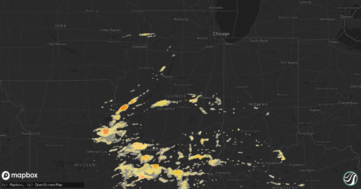
Hail Map in Illinois on May 11, 2016
Get this storm
May 11 map
$229
one time, instant access
Download today. No call, no setup
Keep the $229
Bought the map and want the full workflow? Apply the entire $229 to a subscription within 7 days. None of it is wasted.
Every map, not just this one
This buys you this map. Subscription and you get every map we run, in the markets you choose from a few cities to whole states to nationwide. Plus real-time alerts the moment a storm fires.
Contact data
Name, contact info, occupancy, even credit band for addresses in the footprint. You go from where it hit to who to call.
Become the source they trust
Unlimited branding weather history reports on demand. You already have the documented answer ready for the property owner, and you are the one who showed up with it.
Property data and RoofTrace estimates
Pull up any address you have got, its value and the exact code rules for that jurisdiction, straight from One Click Code. Then RoofTrace estimates the squares, pitch, and roof value, priced the way you price.
Storm reports in Illinois
Illinois
| Date | Description |
|---|---|
| 05/11/20166:24 PM CDT | A local report indicates 1.00 inch wind near DU QUOIN |
| 05/11/20165:23 PM CDT | Wind speed estimate up to 70 mph. |
| 05/11/20165:18 PM CDT | A local report indicates 1.50 inch wind near DU QUOIN |
| 05/11/20165:17 PM CDT | Trees blocking the road west side of evansville. Wind gust 71 mph |
| 05/11/20165:17 PM CDT | A local report indicates 71 MPH wind near MOUNT CARMEL AIRPORT |
| 05/11/20165:15 PM CDT | Quarter to half dollar size hail |
| 05/11/20165:03 PM CDT | A local report indicates 70 MPH wind near BELLAIR |
| 05/11/20165:02 PM CDT | A local report indicates 1.00 inch wind near EVANSVILLE |
| 05/11/20164:57 PM CDT | 65 to 70 mph winds |
| 05/11/20164:55 PM CDT | A local report indicates 60 MPH wind near 3 N HENNING |
| 05/11/20164:45 PM CDT | A local report indicates 1.00 inch wind near 5 S RUMA |
| 05/11/20164:44 PM CDT | A local report indicates 1.00 inch wind near MODOC |
| 05/11/20164:40 PM CDT | Estimated 65 mph winds. Tore off some roof shingles. |
| 05/11/20164:38 PM CDT | Railroad crossing arms broken off. |
| 05/11/20164:30 PM CDT | Power lines blown down. |
| 05/11/20164:25 PM CDT | Trees bent and hanging over the road at route 37. |
| 05/11/20164:25 PM CDT | Trees and power lines down along the mason ebberle road. |
| 05/11/20164:18 PM CDT | Two trees down on roads. |
| 05/11/20164:15 PM CDT | Small tree limbs down |
| 05/11/20164:12 PM CDT | A local report indicates 1.75 inch wind near 1 E GRAYVILLE |
| 05/11/20163:45 PM CDT | Objects blown off porches |
| 05/11/20163:45 PM CDT | Few trees and limbs down |
| 05/11/20163:42 PM CDT | A local report indicates 1.75 inch wind near FAIRFIELD |
| 05/11/20163:38 PM CDT | A local report indicates 1.00 inch wind near RED BUD |
| 05/11/20163:34 PM CDT | A local report indicates 2.00 inch wind near RED BUD |
| 05/11/20163:32 PM CDT | A local report indicates 1.50 inch wind near FAIRFIELD |
| 05/11/20163:30 PM CDT | A local report indicates 1.25 inch wind near RED BUD |
| 05/11/20163:29 PM CDT | Quarter size hail. |
| 05/11/20163:29 PM CDT | Quarter size hail at the airport. |
| 05/11/20163:26 PM CDT | A local report indicates 1.00 inch wind near FAIRFIELD |
| 05/11/20163:24 PM CDT | A local report indicates 62 MPH wind near MONTICELLO |
| 05/11/20163:21 PM CDT | Hail up to egg size reported by trained spotter through sheriff office. |
| 05/11/20163:15 PM CDT | A local report indicates 1.50 inch wind near WAYNE CITY |
| 05/11/20163:15 PM CDT | Tree uprooted. Large branches down. |
| 05/11/20163:13 PM CDT | A local report indicates 66 MPH wind near 1 NW MONTICELLO |
| 05/11/20163:08 PM CDT | Trees down in carlyle. One tree knocked down a power pole near us 50 and il 127. |
| 05/11/20163:05 PM CDT | Trees down |
| 05/11/20163:05 PM CDT | Few trees and limbs down |
| 05/11/20163:00 PM CDT | A local report indicates 1.00 inch wind near 2 N BREESE |
| 05/11/20163:00 PM CDT | Numerous trees and powerlines down. Ponding on roads as well |
| 05/11/20162:56 PM CDT | A few 1.5 ft diameter trees down. Shingles blown off of a few roofs. |
| 05/11/20162:55 PM CDT | Power lines down |
| 05/11/20162:55 PM CDT | Numerous trees and power lines down |
| 05/11/20162:55 PM CDT | Trees and power lines down |
| 05/11/20162:50 PM CDT | 12 inch diameter tree down. |
| 05/11/20162:50 PM CDT | A local report indicates 1.00 inch wind near FULTS |
| 05/11/20162:48 PM CDT | A local report indicates 1.00 inch wind near SHILOH |
| 05/11/20162:48 PM CDT | Power lines down. |
| 05/11/20162:45 PM CDT | Numerous trees down...top part of a silo blown off...power lines down |
| 05/11/20162:40 PM CDT | Large tree down in summerfield. Photo from twitter. Time consistent with radar. |
| 05/11/20162:40 PM CDT | A local report indicates 76 MPH wind near 3 S NEW BADEN |
| 05/11/20162:39 PM CDT | A local report indicates 1.00 inch wind near MAEYSTOWN |
| 05/11/20162:39 PM CDT | A local report indicates 1.00 inch wind near 2 SSW MAEYSTOWN |
| 05/11/20162:38 PM CDT | Numerous trees down |
| 05/11/20162:35 PM CDT | A local report indicates 70 MPH wind near NEW BADEN |
| 05/11/20162:35 PM CDT | Trees down. One blocking route 15. |
| 05/11/20162:35 PM CDT | A local report indicates 1.00 inch wind near SHILOH |
| 05/11/20162:24 PM CDT | Estimated wind gusts of 35-40 mph |
| 05/11/20162:15 PM CDT | Large tree limbs blown down. |
| 05/11/20162:14 PM CDT | A local report indicates 1.00 inch wind near MILLSTADT |
| 05/11/20162:10 PM CDT | A local report indicates 1.00 inch wind near NEW ATHENS |
| 05/11/20162:07 PM CDT | Shingles blown off of a house |
| 05/11/20162:00 PM CDT | Several trees and large limbs down |
| 05/11/20161:58 PM CDT | Northern side of town. |
| 05/11/20161:55 PM CDT | A local report indicates 1.00 inch wind near NEW HANDOVER |
| 05/11/20161:50 PM CDT | A local report indicates 1.00 inch wind near NEW HANDOVER |
| 05/11/20161:39 PM CDT | Multiple tree limbs down. One apple tree snapped at the base. Swop report. |
| 05/11/20161:39 PM CDT | Pea size hail for about 5 minutes. Swop report. Measured wind speed corrected. |
| 05/11/20161:33 PM CDT | Several trees down near il route 29 and indian point road. |
| 05/11/20161:30 PM CDT | Seven power poles snapped at cline rd and il route 123. |
| 05/11/20161:28 PM CDT | 0.5 inch hail also reported. |
| 05/10/201611:16 PM CDT | Several large limbs down in southwest side of the city |
| 05/10/201610:05 PM CDT | Hail ranging from one half inch to one inch. Estimated 40-50 mph winds. |
| 05/10/20169:20 PM CDT | Three quarter inch to one inch diameter hail. |
| 05/10/20167:52 PM CDT | From khqa |
| 05/10/20167:50 PM CDT | A local report indicates 2.00 inch wind near KELLERVILLE |
| 05/10/20167:42 PM CDT | A local report indicates 1.00 inch wind near LIBERTY |
| 05/10/20167:37 PM CDT | A local report indicates 1.75 inch wind near PAYSON |
| 05/10/20167:34 PM CDT | A local report indicates 1.00 inch wind near 3 ESE BURTON |
| 05/10/20167:33 PM CDT | A local report indicates 2.75 inch wind near 3 NE PAYSON |
| 05/10/20167:30 PM CDT | A local report indicates 1.75 inch wind near PAYSON |
| 05/10/20167:29 PM CDT | A local report indicates 1.00 inch wind near MARION |
| 05/10/20167:27 PM CDT | From khqa |
| 05/10/20167:25 PM CDT | A local report indicates 2.75 inch wind near PAYSON |
| 05/10/20167:22 PM CDT | A local report indicates 4.50 inch wind near PAYSON |
| 05/10/20167:17 PM CDT | A local report indicates 2.00 inch wind near PAYSON |
| 05/10/20167:12 PM CDT | A local report indicates 4.50 inch wind near PAYSON |
All States Impacted by Hail Map on May 11, 2016
Cities Impacted by Hail Map on May 11, 2016
- Saint Charles, MO
- Wentzville, MO
- Bridgeton, MO
- Saint Louis, MO
- Hazelwood, MO
- Saint Ann, MO
- Lake Saint Louis, MO
- Defiance, MO
- Chesterfield, MO
- Earth City, MO
- Maryland Heights, MO
- O'Fallon, MO
- Saint Peters, MO
- Silex, MO
- Dover, AR
- Lamar, AR
- Summersville, MO
- Mountain View, MO
- Willow Springs, MO
- Nocona, TX
- Freeburg, IL
- New Baden, IL
- Mascoutah, IL
- Marissa, IL
- New Athens, IL
- Addieville, IL
- Crawford, TN
- Ada, OK
- Sasakwa, OK
- Konawa, OK
- Walters, OK
- Geronimo, OK
- Flora, IL
- Sainte Genevieve, MO
- Mineral Point, MO
- Cadet, MO
- Bismarck, MO
- Park Hills, MO
- Farmington, MO
- Valles Mines, MO
- Bonne Terre, MO
- Blackwell, MO
- Richwoods, MO
- Leadwood, MO
- Potosi, MO
- Stonefort, IL
- Dongola, IL
- Buncombe, IL
- Mount Vernon, IN
- Ewing, MO
- La Grange, MO
- Snyder, TX
- Greenwood, AR
- Merkel, TX
- Trent, TX
- Red Bud, IL
- Coalgate, OK
- Centrahoma, OK
- Centralia, IL
- Clyde, TX
- Raymondville, MO
- Lawton, OK
- Eldorado, OK
- Gould, OK
- Poplar Bluff, MO
- Qulin, MO
- Broseley, MO
- Lesterville, MO
- Booneville, KY
- Timewell, IL
- Clayton, IL
- Stratford, OK
- Laddonia, MO
- Centralia, MO
- Bowling Green, MO
- Curryville, MO
- Hallsville, MO
- Mexico, MO
- Columbia, MO
- Rush Hill, MO
- Thompson, MO
- Martinsburg, MO
- Auxvasse, MO
- Benton City, MO
- Vandalia, MO
- Farber, MO
- Wellsville, MO
- Bellevue, TX
- Flat Rock, IL
- Clarendon, TX
- Claude, TX
- Johnsonville, IL
- Keenes, IL
- Cisne, IL
- Fairfield, IL
- Sims, IL
- Golden Gate, IL
- Bluford, IL
- Geff, IL
- Mount Vernon, IL
- Okawville, IL
- Nashville, IL
- Edgewood, IL
- Mason, IL
- Altamont, IL
- Avoca, WI
- Dodgeville, WI
- Spring Green, WI
- Bourbon, MO
- Fredonia, KY
- Marion, KY
- La Grange, KY
- Crestwood, KY
- Tolar, TX
- Granbury, TX
- Glen Rose, TX
- Danville, KY
- Lancaster, KY
- Stanford, KY
- Wilburton, OK
- Red Oak, OK
- Burkett, TX
- Coleman, TX
- Roff, OK
- Roanoke, VA
- Hardy, VA
- Wirtz, VA
- Vinton, VA
- Moneta, VA
- Comanche, OK
- Duncan, OK
- Hawley, TX
- Pacific, MO
- House Springs, MO
- Catawissa, MO
- Vermont, IL
- Astoria, IL
- Ipava, IL
- Waldron, AR
- Mena, AR
- Parks, AR
- Boles, AR
- Cisco, IL
- White Heath, IL
- Argenta, IL
- Monticello, IL
- New London, MO
- Jonesville, LA
- Liberty, IL
- Hull, IL
- Hannibal, MO
- Payson, IL
- Plainville, IL
- Quincy, IL
- Midlothian, TX
- Center, MO
- Perry, MO
- Boss, MO
- Abilene, TX
- Alton, MO
- Houston, MO
- Mount Sterling, IL
- Martin, TN
- Dresden, TN
- Moran, TX
- Dahlgren, IL
- Childress, TX
- Quanah, TX
- Hollis, OK
- Warrenton, MO
- Marthasville, MO
- Vernon, TX
- Loogootee, IN
- Mountain Park, OK
- Highland, WI
- Blair, OK
- Indiahoma, OK
- Snyder, OK
- Roosevelt, OK
- Marlow, OK
- Norris City, IL
- Broughton, IL
- Belleview, MO
- Bixby, MO
- Black, MO
- Ursa, IL
- Cuba, MO
- Ranger, TX
- Tipton, IA
- Tahlequah, OK
- Oaks, OK
- Peggs, OK
- Hulbert, OK
- Rose, OK
- Twin Oaks, OK
- Kinmundy, IL
- Iuka, IL
- West Frankfort, IL
- Benton, IL
- Orient, IL
- Seminole, OK
- Byars, OK
- Allen, OK
- Austin, IN
- Union, MO
- Fort Smith, AR
- Dawson Springs, KY
- Saint Croix, IN
- Collison, IL
- Lone Wolf, OK
- Granite, OK
- Koshkonong, MO
- Augusta, MO
- Robinson, IL
- Bridgeport, IL
- Lawrenceville, IL
- Sumner, IL
- Jacksboro, TX
- Owensville, IN
- Griffin, IN
- Mount Carmel, IL
- Grayville, IL
- Crossville, IL
- Jayton, TX
- Duke, OK
- Davidson, OK
- Lelia Lake, TX
- Memphis, TX
- Dodson, TX
- Wellington, TX
- Vega, TX
- Hedley, TX
- Chillicothe, TX
- Panhandle, TX
- Amarillo, TX
- Odell, TX
- Groom, TX
- Masterson, TX
- Sullivan, MO
- Leasburg, MO
- Steelville, MO
- Saint James, MO
- Bardstown, KY
- Odon, IN
- Corydon, IN
- Pisgah Forest, NC
- Brevard, NC
- Cedar Mountain, NC
- Middletown, MO
- Fulton, KY
- Teutopolis, IL
- Wheeler, IL
- Newman, IL
- Hume, IL
- Harrellsville, NC
- Morrison, MO
- Hermann, MO
- McKenzie, TN
- Henry, TN
- Mangum, OK
- Kopperl, TX
- Hopkinsville, KY
- Frohna, MO
- Farrar, MO
- Perryville, MO
- Carlyle, IL
- Bedford, IN
- Mitchell, IN
- Campbellsburg, IN
- Springfield, KY
- Lebanon, KY
- Cleveland, SC
- Carrier Mills, IL
- Ravenden, AR
- Harrisonburg, LA
- Smithfield, KY
- Goshen, KY
- Fulton, MO
- Chapin, IL
- Jacksonville, IL
- Pauls Valley, OK
- Leslie, MO
- Gerald, MO
- New Haven, MO
- Clinton, IL
- Dewitt, IL
- Shawnee, OK
- Meeker, OK
- Waurika, OK
- Marysville, IN
- Nabb, IN
- Scottsburg, IN
- Herod, IL
- Ozark, AR
- Sylvester, TX
- East Saint Louis, IL
- Granite City, IL
- Dumas, TX
- McLeansboro, IL
- Macedonia, IL
- Springfield, AR
- Damascus, AR
- Cleburne, TX
- Rosman, NC
- Sunset, SC
- Prairie Du Rocher, IL
- Modoc, IL
- Sparta, IL
- Baldwin, IL
- Walsh, IL
- Festus, MO
- Evansville, IL
- French Village, MO
- Fults, IL
- Ellis Grove, IL
- Chester, IL
- Bloomsdale, MO
- Fairland, IN
- Indianapolis, IN
- Fountaintown, IN
- Water Valley, KY
- Russell Springs, KY
- Princeville, IL
- Cache, OK
- Faxon, OK
- Headrick, OK
- Willow, OK
- New Haven, KY
- Gans, OK
- Dublin, TX
- Cross Plains, TX
- Tye, TX
- Dyess Afb, TX
- Tuscola, TX
- Goldsboro, TX
- Albany, TX
- Buffalo Gap, TX
- McCaulley, TX
- Baird, TX
- May, TX
- Avoca, TX
- Brownwood, TX
- Comanche, TX
- Aspermont, TX
- Novice, TX
- Hamlin, TX
- Rising Star, TX
- Roby, TX
- Cisco, TX
- Anson, TX
- Rotan, TX
- Lueders, TX
- Stamford, TX
- Valmeyer, IL
- High Ridge, MO
- Imperial, MO
- Barnhart, MO
- Fenton, MO
- Columbia, IL
- Arnold, MO
- Bryson, TX
- Cookeville, TN
- Caledonia, MO
- Louisville, KY
- Roscoe, TX
- Breckenridge, TX
- Bluff Dale, TX
- Lipan, TX
- Iredell, TX
- Girard, TX
- Westminster, SC
- Lenzburg, IL
- Goliad, TX
- De Leon, TX
- Jacob, IL
- Kinta, OK
- Ninnekah, OK
- Lebanon Junction, KY
- Dewey, IL
- Mahomet, IL
- Palo Pinto, TX
- Santo, TX
- Saint Libory, IL
- Scott Air Force Base, IL
- Trenton, IL
- Breese, IL
- Lebanon, IL
- Aviston, IL
- Highland, IL
- Saint Jacob, IL
- Summerfield, IL
- Frankford, MO
- Neelyville, MO
- Bellflower, MO
- Anna, IL
- Medora, IN
- Norman, IN
- Channing, TX
- Bloomington, IN
- Mingus, TX
- Montgomery City, MO
- New Florence, MO
- Monterey, TN
- Dalhart, TX
- Nara Visa, NM
- Amistad, NM
- Springdale, AR
- Hartford, AR
- Mansfield, AR
- Marion, IL
- Belleville, IL
- Adrian, TX
- Chrisman, IL
- Clinton, IN
- Ina, IL
- Whittington, IL
- Ewing, IL
- Rockville, IN
- Monroe City, MO
- Stephenville, TX
- Camp Point, IL
- Rushville, IL
- De Witt, IA
- Camanche, IA
- Goose Lake, IA
- Clinton, IA
- Harrisburg, IL
- Como, NC
- Cantrall, IL
- Petersburg, IL
- Athens, IL
- Tyner, NC
- Hobbsville, NC
- Collinsville, IL
- O'Fallon, IL
- Caseyville, IL
- Gorham, IL
- Murphysboro, IL
- Graford, TX
- Mineral Wells, TX
- Mount Pulaski, IL
- Strawn, TX
- Smithton, IL
- Purcell, OK
- Goreville, IL
- Princeton, IN
- Fort Branch, IN
- Eunice, MO
- Yukon, MO
- Park Hill, OK
- Vian, OK
- Cookson, OK
- Bunch, OK
- Gore, OK
- Ballwin, MO
- Wildwood, MO
- Wright City, MO
- Troy, MO
- Albion, IL
- Pinckneyville, IL
- Cutler, IL
- Coulterville, IL
- Junction City, KY
- Ellington, MO
- Marietta, SC
- Easley, SC
- Travelers Rest, SC
- Taylors, SC
- Greenville, SC
- Hodgen, OK
- Heavener, OK
- Carlisle, IN
- Beardstown, IL
- Crossville, TN
- Crofton, KY
- Hico, TX
- Union City, TN
- Brocton, IL
- Foster, OK
- Crawfordsville, IN
- Maud, OK
- Du Bois, IL
- Walnut, IL
- Ohio, IL
- Belle Rive, IL
- Plainville, IN
- Washington, IN
- Henryville, IN
- New Washington, IN
- Charlestown, IN
- Hanover, IN
- Underwood, IN
- Otisco, IN
- Bedford, KY
- Bethlehem, IN
- Westport, KY
- Pendleton, KY
- Lexington, IN
- Van Buren, AR
- Spiro, OK
- Arkoma, OK
- Hagarville, AR
- Williamsburg, MO
- Portland, MO
- De Soto, MO
- Sallisaw, OK
- Muldrow, OK
- Bennettsville, SC
- Hartford, KY
- Eureka, MO
- Pauline, SC
- Arcola, IL
- Tuscola, IL
- Carlton, TX
- Maysville, OK
- Lindsay, OK
- Pleasant Plains, IL
- Sherman, IL
- Elkhart, IL
- Williamsville, IL
- Tallula, IL
- Springfield, IL
- Greenview, IL
- Ashland, IL
- Equality, IL
- Junction, IL
- Brownstown, IN
- Calvin, OK
- Doe Run, MO
- Pembroke, KY
- Robertsville, MO
- Carbon, IN
- Rosedale, IN
- Bridgeton, IN
- Oakdale, IL
- Wayne, OK
- Barry, IL
- Hendersonville, NC
- Waterloo, IL
- Rhineland, MO
- Keota, OK
- Annapolis, IL
- Oakland City, IN
- Charleston, AR
- Rule, TX
- Old Glory, TX
- Caddo, TX
- Eastland, TX
- Gorman, TX
- Carbon, TX
- Sidney, TX
- Santa Anna, TX
- Sweetwater, TX
- Winters, TX
- Vallonia, IN
- Paris, MO
- Dale, IL
- Thompsonville, IL
- Doniphan, MO
- Borger, TX
- Kinderhook, IL
- Clarksville, MO
- Sturgeon, MO
- Kingdom City, MO
- Truxton, MO
- Steedman, MO
- Louisiana, MO
- High Hill, MO
- Camden, IL
- Jonesburg, MO
- Ashland, MO
- Eolia, MO
- Hawk Point, MO
- Versailles, IL
- Fairview, IL
- Farmington, IL
- Brussels, IL
- Batchtown, IL
- Winfield, MO
- Old Monroe, MO
- Jonesboro, IL
- Labadie, MO
- Bone Gap, IL
- Morrison, IL
- Uniontown, KY
- Morganfield, KY
- Walnut Hill, IL
- Fisk, MO
- Browns, IL
- Poseyville, IN
- New Harmony, IN
- Springfield, TN
- Orlinda, TN
- Cook Sta, MO
- Paoli, OK
- Waltonville, IL
- Scheller, IL
- Tamaroa, IL
- Ashley, IL
- Mulkeytown, IL
- Royalton, IL
- Elkville, IL
- Effingham, IL
- Booneville, AR
- Solgohachia, AR
- Center Ridge, AR
- Noble, IL
- Ingraham, IL
- Louisville, IL
- Dieterich, IL
- Newton, IL
- West Liberty, IL
- Couch, MO
- New Salem, IL
- Pittsfield, IL
- Cross Plains, TN
- Portland, TN
- Tunnelton, IN
- Cecil, AR
- Elizabeth, AR
- Viola, AR
- Stilwell, OK
- Waynesburg, KY
- Sharon, SC
- Worthington, IN
- Coal City, IN
- Freedom, IN
- Dora, MO
- Vienna, IL
- Ozark, IL
- Carbondale, IL
- Makanda, IL
- Creal Springs, IL
- Carmi, IL
- Harned, KY
- Vandalia, IL
- Campbell Hill, IL
- Bokoshe, OK
- Clarkesville, GA
- Du Quoin, IL
- New Hope, KY
- Alma, AR
- Godley, TX
- Carmel, IN
- Ennis, TX
- Bradley, OK
- Gainesboro, TN
- Palmyra, MO
- Sandgap, KY
- Mountainburg, AR
- Belgrade, MO
- Mount Gilead, NC
- Albemarle, NC
- Desdemona, TX
- Pickens, SC
- Dixon, MO
- Enfield, IL
- Elizabethtown, IL
- Berger, MO
- Patoka, IL
- West Fork, AR
- Fayetteville, AR
- South Fulton, TN
- Elizabethtown, KY
- Cecilia, KY
- Barnhill, IL
- Salem, KY
- Baylis, IL
- Hustonville, KY
- Florissant, MO
- Chester, AR
- Rudy, AR
- East Alton, IL
- Alton, IL
- Graham, TX
- Maquon, IL
- Yates City, IL
- Sedalia, KY
- Wingo, KY
- Mayfield, KY
- New Middletown, IN
- Catlin, IL
- Westville, IL
- Mcalester, OK
- Dallas, TX
- Vergennes, IL
- Ava, IL
- Hurst, IL
- Dowell, IL
- De Soto, IL
- Carterville, IL
- Christopher, IL
- Eldred, IL
- Princeton, IL
- Wyanet, IL
- Sage, AR
- Melbourne, AR
- Franklin, AR
- Chestnut, IL
- Latham, IL
- Red Oak, TX
- Waxahachie, TX
- Manns Harbor, NC
- Avon, IN
- Brownsburg, IN
- Patterson, MO
- Davisville, MO
- Lonedell, MO
- Saint Mary, MO
- Crystal City, MO
- Nashville, NC
- Rocky Mount, NC
- Jasonville, IN
- Natural Dam, AR
- Greenbrier, AR
- Birch Tree, MO
- Woodlawn, IL
- Sandoval, IL
- Richview, IL
- Irvington, IL
- Dix, IL
- Horseshoe Bend, AR
- Gordon, TX
- White Deer, TX
- Maroa, IL
- Cleveland, GA
- Springerton, IL
- Morgantown, KY
- Shelbyville, MO
- Welling, OK
- Vincent, KY
- Wayne City, IL
- Mount Erie, IL
- West Salem, IL
- Ellery, IL
- Winslow, AR
- Elkins, AR
- Sullivan, IN
- Noble, OK
- Lexington, OK
- Washington, OK
- Martin, GA
- Eastanollee, GA
- Chambersburg, IL
- Griggsville, IL
- Brownstown, IL
- Pevely, MO
- Hillsboro, MO
- Ogden, IL
- Fithian, IL
- Heltonville, IN
- Shawneetown, IL
- Madisonville, KY
- Kampsville, IL
- Nebo, IL
- Mcloud, OK
- Throckmorton, TX
- Edwardsport, IN
- Oaktown, IN
- Fulton, IL
- Cedarville, AR
- Huntingburg, IN
- Saint Elizabeth, MO
- Brimfield, IL
- Hanna City, IL
- Edwards, IL
- Mount Vernon, KY
- Stuart, OK
- Haubstadt, IN
- Calhoun, GA
- Farmer City, IL
- Mansfield, IL
- Weldon, IL
- De Land, IL
- Farina, IL
- Leavenworth, IN
- Eure, NC
- Chamois, MO
- Pocola, OK
- Cameron, OK
- Peace Valley, MO
- Tecumseh, OK
- Skellytown, TX
- Fritch, TX
- Pampa, TX
- Mclean, TX
- Percy, IL
- Maywood, MO
- Taylor, MO
- Jackson, KY
- Ferris, TX
- Rockwood, IL
- Crane, IN
- Salem, MO
- Hattieville, AR
- Lavaca, AR
- Poteau, OK
- Hackett, AR
- Tennyson, IN
- Evansville, AR
- Canehill, AR
- Atoka, OK
- Rosebud, MO
- Owensville, MO
- Tupelo, OK
- Earlsboro, OK
- Pettigrew, AR
- Cynthiana, IN
- Francisco, IN
- Texico, IL
- Seymour, IL
- Champaign, IL
- Halifax, NC
- Alma, IL
- Saint Elmo, IL
- Xenia, IL
- Quinton, OK
- Palmer, TX
- Sautee Nacoochee, GA
- Demorest, GA
- Millstadt, IL
- Eldorado, IL
- Saint Clair, MO
- Sesser, IL
- New Burnside, IL
- Irondale, MO
- Saint Albans, MO
- Cedar Hill, MO
- Viburnum, MO
- Ironton, MO
- Middle Brook, MO
- Cambria, IL
- Herrin, IL
- Bunker, MO
- Beaufort, MO
- Omaha, IL
- Cobden, IL
- Herculaneum, MO
- Villa Ridge, MO
- Gray Summit, MO
- Johnston City, IL
- Foristell, MO
- Galatia, IL
- Zeigler, IL
- Logan, IL
- Cherryville, MO
- Washington, MO
- Pittsburg, IL
- Steeleville, IL
- Buckner, IL
- Parkersburg, IL
- Calhoun, IL
- White Plains, KY
- Toccoa, GA
- Lecompton, KS
- New Canton, IL
- Mccurtain, OK
- Branchville, IN
- English, IN
- Leopold, IN
- Bristow, IN
- Birdseye, IN
- Bement, IL
- Mulberry, AR
- Gleason, TN
- Marion, SC
- Sellers, SC
- Holdenville, OK
- Fairmount, IL
- Oakwood, IL
- Ringgold, TX
- Henrietta, TX
- Foley, MO
- Elsberry, MO
- Depauw, IN
- Milltown, IN
- Jamestown, KY
- Carthage, NC
- Vass, NC
- Lowden, IA
- Solsberry, IN
- Prairie Grove, AR
- Eufaula, OK
- Huntington, AR
- Erick, OK
- Munfordville, KY
- Oblong, IL
- Wellston, OK
- Elkton, KY
- Greenville, KY
- Howe, OK
- Perrin, TX
- Montrose, IL
- Marengo, IN
- Ramsey, IN
- Lowell, AR
- Paradise, TX
- Boyd, TX
- Glen Carbon, IL
- Edwardsville, IL
- Roachdale, IN
- Auburn, KY
- Moscow Mills, MO
- Lancaster, SC
- Peachland, NC
- Alvarado, TX
- Troy, IL
- Speer, IL
- Edelstein, IL
- Danville, AR
- Olmstead, KY
- Sharon Grove, KY
- Guthrie, KY
- Russellville, KY
- Lewisburg, KY
- Trenton, KY
- Allensville, KY
- Newalla, OK
- Pittsburg, OK
- Hindsboro, IL
- Atwood, IL
- Keyesport, IL
- Dillon, SC
- Granville, TN
- Whitleyville, TN
- Sidney, IL
- Broadlands, IL
- Homer, IL
- Longview, IL
- Fort Worth, TX
- Manitou, KY
- Wappapello, MO
- Sacramento, KY
- Hartshorn, MO
- Cannelton, IN
- Payneville, KY
- Arcadia, MO
- Hermleigh, TX
- Loraine, TX
- Virginia, IL
- Macomb, IL
- Cannelburg, IN
- Albany, IL
- Prague, OK
- Talihina, OK
- Macomb, OK
- Paris, IL
- Georgetown, IL
- Indianola, IL
- Sidell, IL
- Ridge Farm, IL
- Elmwood, IL
- West Union, IL
- Hutsonville, IL
- West York, IL
- Wewoka, OK
- Holland, IN
- Hodgenville, KY
- Loretto, KY
- Dittmer, MO
- Simpson, IL
- Salem, IL
- Clay City, IL
- La Belle, MO
- Van Buren, MO
- Dustin, OK
- Golconda, IL
- Waverly, KY
- Rio Vista, TX
- Lyons, IN
- Wetumka, OK
- Alexander, IL
- Tell City, IN
- Derby, IN
- Saluda, NC
- Zirconia, NC
- Union Hall, VA
- Nortonville, KY
- Elnora, IN
- Wadesboro, NC
- Norwood, NC
- Ferdinand, IN
- Mount Sidney, VA
- Loveland, OK
- Oak Grove, KY
- Wapello, IA
- Adairville, KY
- Kiowa, OK
- Danville, IN
- Island, KY
- Centertown, KY
- Central City, KY
- Bremen, KY
- Greenville, MO
- Weatherford, TX
- Hidalgo, IL
- Olney, IL
- Ratcliff, AR
- New Palestine, IN
- Greenwood, IN
- Mill Shoals, IL
- Burnt Prairie, IL
- Allerton, IL
- Gravelly, AR
- Harvey, AR
- Whitefield, OK
- Stigler, OK
- Shelbyville, KY
- Spartanburg, SC
- Roebuck, SC
- Moore, SC
- Elizabeth, IN
- Augusta, IL
- Plymouth, IL
- Palestine, IL
- Cerro Gordo, IL
- Milmine, IL
- Canton, IL
- Clarence, IA
- Perryville, KY
- Linn, MO
- Winslow, IN
- Wardville, OK
- Wanette, OK
- Tiskilwa, IL
- Bureau, IL
- Hennepin, IL
- Cleveland, TN
- De Soto, KS
- Bonner Springs, KS
- Linwood, KS
- Olathe, KS
- Eudora, KS
- Paola, KS
- Edgerton, KS
- Spring Hill, KS
- Wellsville, KS
- Rantoul, KS
- Louisburg, KS
- Bucyrus, KS
- Ringling, OK
- Colchester, IL
- Hartley, TX
- Sunray, TX
- Stinnett, TX
- Hartshorne, OK
- Goodview, VA
- Salem, VA


