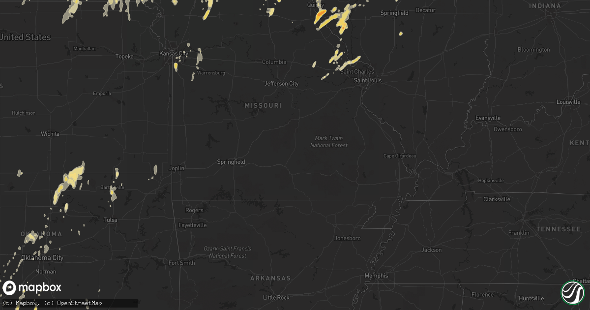
Hail Map in Wisconsin on May 11, 2011
Get this storm
May 11 map
$229
one time, instant access
Download today. No call, no setup
Keep the $229
Bought the map and want the full workflow? Apply the entire $229 to a subscription within 7 days. None of it is wasted.
Every map, not just this one
This buys you this map. Subscription and you get every map we run, in the markets you choose from a few cities to whole states to nationwide. Plus real-time alerts the moment a storm fires.
Contact data
Name, contact info, occupancy, even credit band for addresses in the footprint. You go from where it hit to who to call.
Become the source they trust
Unlimited branding weather history reports on demand. You already have the documented answer ready for the property owner, and you are the one who showed up with it.
Property data and RoofTrace estimates
Pull up any address you have got, its value and the exact code rules for that jurisdiction, straight from One Click Code. Then RoofTrace estimates the squares, pitch, and roof value, priced the way you price.
Storm reports in Wisconsin
Wisconsin
| Date | Description |
|---|---|
| 05/11/20114:50 PM CDT | A local report indicates 1.00 inch wind near 2 SW COTTAGE GROVE |
| 05/11/20114:45 PM CDT | At intersection of broadway and highway 51. |
| 05/11/20114:44 PM CDT | A local report indicates 1.25 inch wind near HARTLAND |
| 05/11/20114:40 PM CDT | A local report indicates 1.00 inch wind near 1 S HARTLAND |
| 05/11/20114:37 PM CDT | A local report indicates 1.00 inch wind near 1 S MONONA |
| 05/11/20114:30 PM CDT | Delayed report. |
| 05/11/20114:28 PM CDT | A local report indicates 1.25 inch wind near 2 S MADISON |
| 05/11/20114:08 PM CDT | A local report indicates 1.25 inch wind near NE VERONA |
| 05/11/20112:56 PM CDT | A local report indicates 1.00 inch wind near 5 E SPARTA |
| 05/11/20112:43 PM CDT | A local report indicates 1.75 inch wind near S JEFFERSON |
| 05/11/20112:40 PM CDT | A local report indicates 2.00 inch wind near 1 N JEFFERSON |
| 05/11/20112:40 PM CDT | Delayed report of baseball sized hail and broken windows. |
| 05/11/20112:34 PM CDT | Softball size hail reported at intersection of highways 18 and 89. |
| 05/11/20112:30 PM CDT | A local report indicates 1.00 inch wind near 4 WNW LAKE MILLS |
| 05/11/20112:28 PM CDT | A local report indicates 1.00 inch wind near 1 W SUN PRAIRIE |
| 05/11/20112:26 PM CDT | Reported by sheriff deputy at intersection of highway 12 and highway j. |
| 05/11/20112:01 PM CDT | Hail damage to police cars on highway 16 se of tomah. |
| 05/11/20112:00 PM CDT | Delayed report. Video and images of ice cube sized hail in traffic on i-90. |
| 05/11/20111:47 PM CDT | A local report indicates 1.25 inch wind near 1 E MADISON TRUAX AIRPO |
| 05/11/20111:47 PM CDT | A local report indicates 1.50 inch wind near 2 E MADISON TRUAX AIRPO |
| 05/11/20111:45 PM CDT | A local report indicates 1.25 inch wind near 3 E MADISON |
| 05/11/20111:43 PM CDT | A local report indicates 1.00 inch wind near MCFARLAND |
| 05/11/20111:43 PM CDT | A local report indicates 1.00 inch wind near 2 E MADISON TRUAX AIRPO |
| 05/11/20111:41 PM CDT | A local report indicates 1.00 inch wind near MADISON TRUAX AIRPORT |
| 05/11/20111:36 PM CDT | A local report indicates 1.00 inch wind near 1 E MADISON |
| 05/11/201111:47 AM CDT | Minor branch damage |
| 05/11/201111:30 AM CDT | A local report indicates 1.00 inch wind near 2 SSW MENOMONIE |
| 05/11/20119:38 AM CDT | A local report indicates 1.00 inch wind near OCONTO FALLS |
| 05/11/20119:37 AM CDT | Delayed report |
| 05/11/20117:00 AM CDT | A local report indicates 1.00 inch wind near POUND |
All States Impacted by Hail Map on May 11, 2011
Cities Impacted by Hail Map on May 11, 2011
- Marble Falls, TX
- Johnson City, TX
- Llano, TX
- Horseshoe Bay, TX
- Round Mountain, TX
- Williamstown, MO
- Kahoka, MO
- Saint Patrick, MO
- Maple City, MI
- Chase, KS
- Raymond, KS
- Madison, WI
- Vona, CO
- Anabel, MO
- Atlanta, MO
- Macon, MO
- Macomb, IL
- Wellington, MO
- Bates City, MO
- Holden, MO
- Napoleon, MO
- Odessa, MO
- Northport, MI
- Plymouth, OH
- Shiloh, OH
- Audubon, IA
- Temple, TX
- Bellevue, TX
- Morrisonville, IL
- Burlington, CO
- Elgin, OK
- Mesick, MI
- Alva, OK
- Wahoo, NE
- Ithaca, NE
- Barnard, KS
- Kansas, OH
- Wayne, OH
- Fostoria, OH
- Risingsun, OH
- Egg Harbor, WI
- Peshtigo, WI
- Marinette, WI
- Sturgeon Bay, WI
- Elk Mound, WI
- Colfax, WI
- Falls City, NE
- Horton, KS
- Hiawatha, KS
- Fairview, KS
- Eldorado, TX
- Palmyra, WI
- Dousman, WI
- Burlington, WI
- Dexter, MI
- Chelsea, MI
- Ann Arbor, MI
- Krakow, WI
- Abrams, WI
- Oconto Falls, WI
- Little Suamico, WI
- Oconto, WI
- Lena, WI
- Gillett, WI
- Cecil, WI
- Calumet, OK
- Okarche, OK
- El Reno, OK
- Britton, MI
- Westmoreland, KS
- Rapid City, MI
- Alden, MI
- Macedonia, IA
- Ludington, MI
- Melvin, TX
- Old Monroe, MO
- Golden Eagle, IL
- Wentzville, MO
- Grafton, IL
- Brussels, IL
- O'Fallon, MO
- Winfield, MO
- Skiatook, OK
- Paw Paw, MI
- Mattawan, MI
- Kiel, WI
- Catawba, WI
- Prentice, WI
- Kennan, WI
- Eden, TX
- La Plata, MO
- Mount Sterling, IL
- New Salem, IL
- New London, MO
- Rockport, IL
- Baylis, IL
- Versailles, IL
- Chambersburg, IL
- Hull, IL
- Pittsfield, IL
- Nebo, IL
- Beardstown, IL
- Pleasant Hill, IL
- Perry, IL
- Barry, IL
- New Canton, IL
- Frankford, MO
- Kinderhook, IL
- Griggsville, IL
- Arenzville, IL
- Clarence, MO
- Olsburg, KS
- Manhattan, KS
- Goldthwaite, TX
- Pottsville, TX
- Hamilton, TX
- San Saba, TX
- Mullin, TX
- Winfield, KS
- Burden, KS
- Pound, WI
- Tomah, WI
- Wilton, WI
- Warrens, WI
- North Aurora, IL
- Aurora, IL
- Batavia, IL
- Tippecanoe, IN
- Mentone, IN
- Warsaw, IN
- Bourbon, IN
- Etna Green, IN
- Guthrie, OK
- Weldon, IA
- Garden Grove, IA
- Elk Creek, VA
- Independence, VA
- Joliet, IL
- Lockport, IL
- Prague, NE
- Del Rio, TX
- Comstock, TX
- Mchenry, IL
- Fox Lake, IL
- Spring Grove, IL
- Sterling, NE
- Tecumseh, NE
- Onondaga, MI
- Rives Junction, MI
- Holland, MI
- Fullerton, NE
- Sheridan, MO
- Clarinda, IA
- Morrill, KS
- Sabetha, KS
- Dryden, TX
- Salado, TX
- Killeen, TX
- Jarrell, TX
- Belton, TX
- Bartlett, TX
- Florence, TX
- Georgetown, TX
- Independence, KS
- Cainsville, MO
- Crystal Lake, IL
- Woodstock, IL
- Channahon, IL
- Mereta, TX
- Miles, TX
- San Angelo, TX
- Eola, TX
- Gilman City, MO
- Junction, TX
- Wimberley, TX
- Blanco, TX
- Ashland, OH
- Greenwich, OH
- Mansfield, OH
- Wymore, NE
- Lorena, TX
- Bruceville, TX
- Hewitt, TX
- McGregor, TX
- Moody, TX
- Waco, TX
- Voss, TX
- Ruthven, IA
- Terril, IA
- Dickens, IA
- Foster, OK
- Duncan, OK
- Marlow, OK
- Comanche, OK
- Loco, OK
- Rhinelander, WI
- Brackettville, TX
- Henrietta, TX
- Callao, MO
- Ulysses, NE
- Crivitz, WI
- Adrian, MI
- Palmyra, MI
- Jasper, MI
- Sauk City, WI
- Mazomanie, WI
- Russell, KS
- Great Bend, KS
- Hoisington, KS
- Olmitz, KS
- Lineville, IA
- Princeton, MO
- Mercer, MO
- Millbury, OH
- Walbridge, OH
- Oregon, OH
- Perrysburg, OH
- Harbor View, OH
- Toledo, OH
- Northwood, OH
- Yukon, OK
- Mustang, OK
- Maple City, KS
- Dexter, KS
- Cedar Vale, KS
- Kaw City, OK
- Burbank, OK
- Ponca City, OK
- Shidler, OK
- Newkirk, OK
- Bellwood, NE
- Chillicothe, TX
- Odell, TX
- Vernon, TX
- Christoval, TX
- Hartland, WI
- Fort Worth, TX
- Lakemont, GA
- Elsberry, MO
- Silex, MO
- Troy, MO
- Hawk Point, MO
- Foley, MO
- Springfield, NE
- Louisville, NE
- Murdock, NE
- Wheeler, TX
- Briscoe, TX
- Morris, IL
- Santa Anna, TX
- Knox, IN
- Northbrook, IL
- Highland Park, IL
- Glencoe, IL
- Kingfisher, OK
- Mason, TX
- Osceola, NE
- Stromsburg, NE
- Ridgeway, MO
- Bethany, MO
- Eagleville, MO
- Quemado, TX
- Coleman, WI
- Porterfield, WI
- La Valle, WI
- Lyndon Station, WI
- Dane, WI
- Deforest, WI
- Camp Douglas, WI
- Manistee, MI
- Chippewa Falls, WI
- Eau Claire, WI
- Dowling, MI
- Hastings, MI
- San Jose, IL
- Delavan, IL
- Mason City, IL
- Green Valley, IL
- Easton, IL
- Petersburg, IL
- Oakford, IL
- Quincy, IL
- Payson, IL
- Hayes Center, NE
- Palisade, NE
- Wauneta, NE
- Albany, WI
- Farragut, IA
- Buda, TX
- Driftwood, TX
- San Marcos, TX
- Kyle, TX
- Mountain Rest, SC
- Westminster, SC
- Long Creek, SC
- Walhalla, SC
- Brownwood, TX
- Early, TX
- Blanket, TX
- Zephyr, TX
- Polk, NE
- Bradshaw, NE
- Sparta, WI
- Duke, OK
- Kingsland, TX
- Fredericksburg, TX
- Willow City, TX
- Nelson, NE
- Weston, NE
- Ceresco, NE
- Harrietta, MI
- Welch, OK
- Sweetwater, OK
- Athelstane, WI
- Genoa, NE
- Silver Creek, NE
- Clarks, NE
- Weatherford, OK
- Thomas, OK
- Granite, OK
- Jeromesville, OH
- Imogene, IA
- Shenandoah, IA
- Essex, IA
- Bedford, IA
- Nodaway, IA
- New Market, IA
- Creston, IA
- Gravity, IA
- Sharpsburg, IA
- Prescott, IA
- Carbon, IA
- Villisca, IA
- Corning, IA
- Stanton, IA
- Red Oak, IA
- Lenox, IA
- Paint Rock, TX
- Rowena, TX
- Reydon, OK
- Crawford, OK
- Cedar Rapids, NE
- Cisco, TX
- Rising Star, TX
- Cheyenne, OK
- Sutton, NE
- Geneva, NE
- Fairmont, NE
- Grafton, NE
- Charlotte, MI
- Vermillion, SD
- Wilmington, IL
- Arcadia, OK
- Hopkins, MI
- Dorr, MI
- Tiffin, OH
- Bradner, OH
- West Millgrove, OH
- Red Rock, OK
- Marland, OK
- Tonkawa, OK
- Tampico, IL
- Murray, NE
- Weeping Water, NE
- Nehawka, NE
- Rocksprings, TX
- Barksdale, TX
- Plainville, IL
- Hannibal, MO
- Buckholts, TX
- Holland, TX
- Rogers, TX
- Marlin, TX
- Whiting, IA
- Salix, IA
- Sloan, IA
- Climbing Hill, IA
- Hornick, IA
- Bronson, IA
- Winnebago, NE
- Hartley, IA
- Schaumburg, IL
- Elk Grove Village, IL
- Sonora, TX
- New Hampton, MO
- Albany, MO
- Martinsville, MO
- Fort Hood, TX
- Spring Hill, KS
- Caddo, TX
- Breckenridge, TX
- Rock Port, MO
- Stanley, WI
- Springtown, TX
- Mead, NE
- Oneida, KS
- Sheffield, IL
- Saint Edward, NE
- Chico, TX
- Sunset, TX
- Mcfarland, WI
- Sun Prairie, WI
- Verona, WI
- Milford, NE
- Pleasant Dale, NE
- Seward, NE
- Waurika, OK
- Watertown, WI
- Alto, MI
- Fall Creek, WI
- Altoona, WI
- Castell, TX
- Buchanan Dam, TX
- Doss, TX
- Elgin, IL
- Maple Park, IL
- Hampshire, IL
- Gilberts, IL
- Huntley, IL
- Carpentersville, IL
- Algonquin, IL
- Lake In The Hills, IL
- Dundee, IL
- Crockett, TX
- Groveton, TX
- Pennington, TX
- Dodge City, KS
- Green Castle, MO
- Green City, MO
- Three Oaks, MI
- Rolling Prairie, IN
- New Carlisle, IN
- La Porte, IN
- Galien, MI
- Rush Center, KS
- Albert, KS
- Otis, KS
- Stoughton, WI
- Oregon, WI
- Jefferson, WI
- Cambridge, WI
- Lake Mills, WI
- Johnson Creek, WI
- Deerfield, WI
- Helenville, WI
- Cottage Grove, WI
- Waterloo, WI
- Fort Atkinson, WI
- Millersburg, OH
- Fresno, OH
- Kansas City, MO
- Ninnekah, OK
- Rush Springs, OK
- Walters, OK
- Temple, OK
- Oskaloosa, IA
- Benton, IA
- Campobello, SC
- Bremen, IN
- Smithville, OK
- Watson, OK
- Elmo, MO
- Burlington Junction, MO
- Ballinger, TX
- Talpa, TX
- Coleman, TX
- Hawarden, IA
- Stephenson, MI
- Randall, KS
- Jewell, KS
- Frankfort, KS
- Argos, IN
- Hardy, NE
- Byron, NE
- Deshler, NE
- Bartlesville, OK
- Ochelata, OK
- Ramona, OK
- Bridgeport, TX
- Nelson, WI
- York, NE
- Hampton, NE
- Barnes, KS
- Wellington, OH
- Carleton, NE
- Hebron, NE
- Shickley, NE
- Silver City, IA
- Malvern, IA
- Glenwood, IA
- Wellsville, KS
- Rantoul, KS
- Edgerton, KS
- Williamston, MI
- Crete, NE
- Scottville, MI
- Stockbridge, MI
- Hordville, NE
- La Harpe, IL
- Blandinsville, IL
- Bertram, TX
- Chesterton, IN
- Valparaiso, IN
- Mineral Wells, TX
- Alvord, TX
- Minooka, IL
- Shorewood, IL
- Plainfield, IL
- Craig, MO
- Forest City, MO
- Carlton, TX
- Olney, TX
- Richland Springs, TX
- Rochelle, TX
- Johnstown, NE
- Scotland, TX
- Edina, MO
- Novelty, MO
- Taylor, NE
- Columbus, NC
- Cashion, OK
- Tamassee, SC
- West Union, SC
- Frontenac, KS
- Pittsburg, KS
- Gould, OK
- Garland, NE
- Brady, TX
- Hamburg, IA
- Sidney, IA
- Emerson, IA
- Randolph, IA
- Westboro, MO
- Northboro, IA
- Tarkio, MO
- Delphos, KS
- Lawton, OK
- Jacksboro, TX
- Garden City, MO
- Pleasant Hill, MO
- Kingsville, MO
- Tremont, IL
- Neodesha, KS
- Elk City, KS
- Leonard, MO
- Wausaukee, WI
- Pembine, WI
- Amberg, WI
- Dunbar, WI
- Daggett, MI
- Lane, OK
- Spickard, MO
- King City, MO
- Luther, MI
- Justin, TX
- Ponder, TX
- Coldwater, MI
- Minco, OK
- Anadarko, OK
- Pocasset, OK
- Salem, SC
- Atwood, KS
- Denver, MO
- Gentry, MO
- Helena, OH
- Gibsonburg, OH
- Balko, OK
- Oak Lawn, IL
- Palos Hills, IL
- Burbank, IL
- Willow Springs, IL
- Justice, IL
- Bridgeview, IL
- Worth, IL
- Palos Park, IL
- Chicago Ridge, IL
- Hickory Hills, IL
- Lemont, IL
- Willowbrook, IL
- Robinson, KS
- Fairfax, MO
- White Cloud, KS
- Oregon, MO
- Mound City, MO
- Rulo, NE
- Maitland, MO
- Fillmore, MO
- Winters, TX
- Wolbach, NE
- Graford, TX
- Graham, TX
- Minneapolis, KS
- Lindsay, OK
- Quanah, TX
- Table Rock, NE
- Johnson, NE
- Elk Creek, NE
- Cook, NE
- Lawrence, MI
- Percival, IA
- Gregory, MI
- Fowlerville, MI
- Webberville, MI
- Mundelein, IL
- Vernon Hills, IL
- Unionville, MO
- Crowell, TX
- Pewaukee, WI
- Delafield, WI
- Nashotah, WI
- Landrum, SC
- Tryon, NC
- Franklin, TX
- Hearne, TX
- Plymouth, IN
- Culver, IN
- North Judson, IN
- Hamlet, IN
- Grovertown, IN
- Nekoma, KS
- Grandview, MO
- Crescent, OK
- Prospect Heights, IL
- Mount Prospect, IL
- Glenview, IL
- Wallace, NE
- Staplehurst, NE
- Surprise, NE
- Bangs, TX
- Brookesmith, TX
- Wautoma, WI
- Coloma, WI
- Westfield, WI
- Wright, KS
- Waunakee, WI
- Rosebud, TX
- Lott, TX
- Odell, NE
- Bremen, KS
- Marysville, KS
- Kirksville, MO
- Argonne, WI
- Stanberry, MO
- Plattsmouth, NE
- Marion, MI
- Nolanville, TX
- Harker Heights, TX
- Briggs, TX
- Benedict, KS
- Altoona, KS
- Thayer, KS
- Chanute, KS
- Belleville, WI
- Brooklyn, WI
- Dewey, OK
- Elliott, IA
- Pollock, MO
- Lucerne, MO
- Newtown, MO
- Shepherd, TX
- Livingston, TX
- Goodrich, TX
- Arkansas City, KS
- Wayland, MI
- Shelbyville, MI
- Medicine Park, OK
- Schuyler, NE
- Hext, TX
- Menard, TX
- Durand, WI
- Menomonie, WI
- Fontanelle, IA
- Tupelo, OK
- Stonewall, OK
- Friendship, WI
- Plainfield, WI
- Hancock, WI
- Lincoln, KS
- Almond, WI
- Wild Rose, WI
- Eagle, MI
- Portland, MI
- Pinckney, MI
- Howell, MI
- Clarkson, NE
- Leigh, NE
- Miltonvale, KS
- Union Star, MO
- Darlington, MO
- Wellston, MI
- Brethren, MI
- Free Soil, MI
- Oglesby, TX
- Gatesville, TX
- Kempner, TX
- Lampasas, TX
- Copperas Cove, TX
- Burnet, TX
- Caledonia, MI
- Middleville, MI
- Tescott, KS
- Leon, IA
- Mondovi, WI
- Skidmore, MO
- Kendall, WI
- Beaver, OK
- Decatur, TX
- Troutdale, VA
- Mouth Of Wilson, VA
- Powersville, MO
- Belleville, MI
- Ypsilanti, MI
- Mulliken, MI
- Frederick, OK
- Kellerton, IA
- Merrimac, WI
- Baraboo, WI
- Humeston, IA
- Liberty, IL
- Edmond, OK
- Ottawa Lake, MI
- Gleason, WI
- Glen Flora, WI
- Tony, WI
- Ogema, WI
- Brantwood, WI
- Delton, MI
- Toccoa, GA
- Brevard, NC
- Rosman, NC
- Lake Toxaway, NC
- Sunset, SC
- Tiger, GA
- Clarkesville, GA
- Harris, MO
- Milan, MO
- Michigan City, IN
- Westville, IN
- Hobart, IN
- Woodway, TX
- Washington, KS
- Idalia, CO
- Orlando, FL
- Phillips, WI
- Bostic, NC
- Ellenboro, NC
- Novice, TX
- Lawn, TX
- Goldsboro, TX
- Liberty, NE
- Oketo, KS
- Hamilton, IL
- Telephone, TX
- Allerton, IA
- Corydon, IA
- Jetmore, KS
- Amherst, WI
- Dewitt, MI
- Cherokee, TX
- Sterling City, TX
- Keller, TX
- Tomahawk, WI
- Gallatin, MO
- Jameson, MO
- Oconomowoc, WI
- Sussex, WI
- Colgate, WI
- Bridgewater, IA
- Liberty Hill, TX
- Lodi, WI
- Jamesport, MO
- Morse Bluff, NE
- Colon, NE
- Malmo, NE
- Madison, NE
- Indiahoma, OK
- Ranger, TX
- Strawn, TX
- Wann, OK
- Caney, KS
- Copan, OK
- Speedwell, VA
- Rural Retreat, VA
- Newcastle, TX
- Columbus, NE
- Hamlin, IA
- Exira, IA
- Hazelhurst, WI
- Tripoli, WI
- Sweetwater, TX
- Nocona, TX
- Mulhall, OK
- Chilton, TX
- Eddy, TX
- Durand, IL
- Brodhead, WI
- Davis, IL
- Mankato, KS
- Moulton, IA
- Unionville, IA
- Centerville, IA
- Udell, IA
- University Park, IA
- Eddyville, IA
- Spearville, KS
- Ford, KS
- Eastland, TX
- Greenville, TX
- Fountain, MI
- Branch, MI
- Rutherfordton, NC
- Oklahoma City, OK
- Lucas, KS
- Black River Falls, WI
- Shannon City, IA
- Gainesville, TX
- Bern, KS
- Byron Center, MI
- Hamilton, MI
- Allegan, MI
- Hudsonville, MI
- Zeeland, MI
- Perry, OK
- Orlando, OK
- Momence, IL
- Utica, NE
- Gresham, NE
- Waco, NE
- Syracuse, NE
- Unadilla, NE
- Nebraska City, NE
- Dunbar, NE
- Webber, KS
- Formoso, KS
- Bowie, TX
- Lac Du Flambeau, WI
- Finley, OK
- Moyers, OK
- Antlers, OK
- Richmond, IL
- Pacific Junction, IA
- Amity, MO
- Goff, KS
- Soldier, KS
- Concordia, KS
- Aurora, KS
- Clyde, KS
- Eaton Rapids, MI
- Glasco, KS
- Garnett, KS
- Adams, NE
- Cortland, NE
- Coin, IA
- Blanchard, IA
- Piedmont, KS
- Dorchester, NE
- Conway Springs, KS
- Viola, KS
- Hinckley, IL
- Avoca, NE
- Otoe, NE
- Yorkville, IL
- Rib Lake, WI
- Breckenridge, MO
- Hamilton, MO
- Suring, WI
- Palmer, NE
- Central City, NE
- Archer, NE
- Binger, OK
- Grand Ledge, MI
- Dillard, GA
- Cazenovia, WI
- Osceola, IA
- Murray, IA
- Homer, NE
- Luther, OK
- Blakesburg, IA
- Drakesville, IA
- Ottumwa, IA
- Valera, TX
- Beatrice, NE
- Fairbury, NE
- Alcester, SD
- Hudson, SD
- Stringtown, OK
- Creston, NE
- Spicewood, TX
- Clyde, TX
- Luray, KS
- New Glarus, WI
- Kennard, TX
- Forestburg, TX
- Saint Jo, TX
- Muenster, TX
- Albion, MI
- Homer, MI
- Monmouth, IL
- Addison, IL
- Itasca, IL
- Wood Dale, IL
- Royal, IA
- Everly, IA
- Spencer, IA
- Bryson, TX
- Bruno, NE
- Cache, OK
- Moville, IA
- Canute, OK
- Three Lakes, WI
- Harper, TX
- Comanche, TX
- Voca, TX
- Hennessey, OK
- Evansville, WI
- Janesville, WI
- Poolville, TX
- Weatherford, TX
- Whitt, TX
- Buckner, MO
- Baird, TX
- Edgar, NE
- Grand Island, NE
- Chapman, NE
- Pawnee, OK
- Irons, MI
- Parma, MI
- Ellsworth, KS
- Wilson, KS
- Sylvan Grove, KS
- Nashville, MI
- Vermontville, MI
- Greenleaf, KS
- La Belle, MO
- Benzonia, MI
- Frankfort, MI
- Grand Ridge, IL
- Marseilles, IL
- Ransom, IL
- Trenton, MO
- Saint Charles, IL
- Wayne, IL
- South Elgin, IL
- Coal City, IL
- Valparaiso, NE
- Concord, MI
- Carbon, TX
- Avon, IL
- Virginia, IL
- Waukegan, IL
- Zion, IL
- Helena, MO
- Beverly, KS
- Watonga, OK
- Sylva, NC
- Roff, OK
- Tustin, MI
- McBain, MI
- Leroy, MI
- Cadillac, MI
- Cornell, WI
- Whitewater, WI
- Lambertville, MI
- Temperance, MI
- Maitland, FL
- Winter Park, FL
- Wisner, NE
- Seneca, KS
- Smithland, IA
- Fort Pierce, FL
- Grassy Creek, NC
- Geary, OK
- Waterville, KS
- Hanover, KS
- Exline, IA
- Cincinnati, IA
- Blackstone, IL
- Kinsman, IL
- New Lisbon, WI
- Jansen, NE
- Stratton, CO
- Stanton, NE
- Lake, MI
- Harrison, MI
- Loudonville, OH
- Bluff City, KS
- Tow, TX
- Valley Spring, TX
- Lake Geneva, WI
- Elkhorn, WI
- Marthasville, MO
- Warrenton, MO
- Chattanooga, OK
- Loveland, OK
- Mangum, OK
- Olustee, OK
- Kanorado, KS
- Bellevue, NE
- Papillion, NE
- Erick, OK
- Ursa, IL
- Mendon, IL
- Fowler, IL
- Pender, NE
- Plymouth, NE
- De Witt, NE
- Palmer, KS
- Lindsay, NE
- Maxwell, NE
- Wonder Lake, IL
- Hebron, IL
- New Florence, MO
- Lakeville, OH
- Elkhart Lake, WI
- Custer, MI
- Wilber, NE
- Morrowville, KS
- Afton, IA
- Tennessee, IL
- Plymouth, IL
- Willow, OK
- Elkhart, TX
- Glencoe, OK
- Stillwater, OK
- Evart, MI
- Corrigan, TX
- Oberlin, KS
- Moscow Mills, MO
- Groesbeck, TX
- Gracemont, OK
- Clayton, IL
- Art, TX
- Clayton, GA
- Loraine, TX
- Roscoe, TX
- Onekama, MI
- Bear Lake, MI
- Union City, OK
- Seibert, CO
- Cameron, TX
- Gause, TX
- McCool Junction, NE
- Galesburg, MI
- Norfolk, NE
- Raymore, MO
- Belton, MO
- Hurdland, MO
- Elroy, WI
- Mauston, WI
- Linn, KS
- Waupaca, WI
- Dresden, KS
- Dawson, NE
- Du Bois, NE
- Humboldt, NE
- Salem, NE
- Wolfe City, TX
- Necedah, WI
- Eureka, KS
- Cushing, OK
- Braymer, MO
- Lock Springs, MO
- Crandon, WI
- Pawhuska, OK
- Stanfield, NC
- Midland, NC
- Monroe, NC
- Waterford, WI
- Union Grove, WI
- Berger, MO
- Beloit, KS
- Courtland, KS
- Lorimor, IA
- Manchester, OK
- Anthony, KS
- Athens, IL
- Decatur, IA
- Dublin, TX
- Shelbina, MO
- Grandville, MI
- Jenison, MI
- Grand Rapids, MI
- Wyoming, MI
- Paola, KS
- Eudora, KS
- Baldwin City, KS
- Bison, KS
- Marshall, WI
- Shawano, WI
- Ringwood, IL
- Colby, KS
- Hustler, WI
- Gorman, TX
- Shreve, OH
- Clearfield, IA
- Hatfield, MO
- Blythedale, MO
- Chillicothe, MO
- Agenda, KS
- Belleville, KS
- Independence, MO
- Genoa, OH
- Curtice, OH
- Grapeland, TX
- Douglas, NE
- Firth, NE
- Filley, NE
- Blue Springs, NE
- Hickman, NE
- Bennet, NE
- Pickrell, NE
- Crab Orchard, NE
- Rattan, OK
- Thayer, IA
- Ellston, IA
- Evant, TX
- Gouldbusk, TX
- Sergeant Bluff, IA
- Fort McKavett, TX
- Leslie, MI
- Galesburg, IL
- Davidson, OK
- Malcolm, NE
- Raymond, NE
- Monroe, WI
- Juda, WI
- Watson, MO
- Shamrock, TX
- Holcombe, WI
- Conrath, WI
- Ryan, OK
- Marquette, NE
- Henderson, NE
- Stroud, OK
- Normangee, TX
- Girard, KS
- Burr, NE
- Saint Cloud, FL
- Foristell, MO
- North Manchester, IN
- Seagoville, TX
- Forney, TX
- Tipton, KS
- Osborne, KS
- Elkhart, IL
- Windthorst, TX
- Greenfield, IA
- Denton, TX
- Stark, KS
- Cross Plains, TX
- Milligan, NE
- Kaleva, MI
- Copemish, MI
- Pelican Lake, WI
- Fredonia, TX
- Dallas City, IL
- Lawton, IA
- Sioux City, IA
- Pawnee City, NE
- Lewiston, NE
- Burchard, NE
- Steinauer, NE
- Poynette, WI
- Dodge, NE
- Beemer, NE
- Howells, NE
- West Point, NE
- Hayesville, OH
- Big Prairie, OH
- Perrysville, OH
- Shelby, OH
- Dwight, NE
- Baileyville, KS
- Axtell, KS
- Minneola, KS
- Chickasha, OK
- Pattonsburg, MO
- Dekalb, IL
- Ingleside, IL
- Elburn, IL
- Grant City, MO
- Worth, MO
- Harrold, TX
- Henderson, IA
- Durham, OK
- Thurman, IA
- Portage, IN
- Verdon, NE
- Centralia, KS
- Wichita, KS
- Colwich, KS
- Goddard, KS
- Maize, KS
- Bunker Hill, KS
- Bushton, KS
- Holyrood, KS
- Claflin, KS
- Burkett, TX
- Abingdon, IL
- Maquon, IL
- Riesel, TX
- New Virginia, IA
- Phillips, NE
- Garden City, TX
- Westbrook, TX
- Bucklin, KS
- Arlington, WI
- Rio, WI
- Culbertson, NE
- Diagonal, IA
- Argyle, TX
- Duncan, NE
- Monroe, NE
- Jackson, MI
- David City, NE
- Burdett, KS
- Olivet, MI
- Bellevue, MI
- Harshaw, WI
- Dwight, IL
- Diller, NE
- La Crosse, KS
- Larned, KS
- Moran, TX
- Kingston, OK
- Glen Ellyn, IL
- Glendale Heights, IL
- Lombard, IL
- Lamoni, IA
- Orrick, MO
- Excelsior Springs, MO
- Highlands, NC
- Cedar, MI
- Springfield, WI
- Sparta, MI
- London Mills, IL
- Morrison, OK
- Park Falls, WI
- Boyd, WI
- Humboldt, KS
- Colchester, IL
- Muir, MI
- Fenwick, MI
- Ionia, MI
- Ruskin, NE
- Republic, KS
- Norton, TX
- Barrington, IL
- Cary, IL
- Diboll, TX
- Lovelady, TX
- Trinity, TX
- Crockett, VA
- Crumpler, NC
- Piney Creek, NC
- Wytheville, VA
- Springport, MI
- Wright City, MO
- Ringgold, TX
- Hartington, NE
- Newcastle, NE
- Wynot, NE
- Argonia, KS
- Freeport, KS
- Knox City, MO
- Wonewoc, WI
- Florence, WI
- Manitowoc, WI
- Valders, WI
- Newton, WI
- Brainard, NE
- Riverton, IA
- Lansing, NC
- Libertyville, IL
- Grayslake, IL
- Gurnee, IL
- Berkey, OH
- Blissfield, MI
- Metamora, OH
- Thornton, TX
- Kosse, TX
- Elmer, OK
- Bellevue, OH
- Columbus, KS
- Chetopa, KS
- Danbury, NE
- Sidney, TX
- Milton, KS
- Garden Plain, KS
- Union, NE
- Humphreys, MO
- Plainwell, MI
- Hinton, OK
- Sheridan, MI
- Bruning, NE
- Strang, NE
- Davenport, NE
- Burkburnett, TX
- Randlett, OK
- Wichita Falls, TX
- Bassett, NE
- Bryan, TX
- Apache, OK
- Battle Creek, MI
- Sanger, TX
- Ringling, OK
- Wallace, MI
- Cedar Springs, MI
- Perrin, TX
- Home, KS
- Columbus, WI
- Jones, OK
- Hawkins, WI
- Hopedale, IL
- Green Springs, OH
- Clay Center, KS
- Jerseyville, IL
- Pentwater, MI
- Arkdale, WI
- Broaddus, TX
- Orient, IA
- Bethune, CO
- Mart, TX
- Stuart, IA
- Bee, NE
- Clatonia, NE
- Swanton, NE
- Endicott, NE
- Antioch, IL
- Emmetsburg, IA
- Graettinger, IA
- Fremont, OH
- Troy, TX
- Coshocton, OH
- Calvin, OK
- Stuart, OK
- Aurora, NE
- Granger, TX
- Leander, TX
- Priddy, TX
- Little River Academy, TX
- Pontotoc, TX
- Mountain Home, TX
- Bluffton, TX
- Kalamazoo, MI
- Brashear, MO
- Jasper, TX
- Orange City, IA
- Longford, KS
- Honor, MI
- Lake Tomahawk, WI
- Carnegie, OK
- Miami, OK
- Evanston, IL
- Wilmette, IL
- Skokie, IL
- May, TX
- Carter, OK
- Sentinel, OK
- Lone Wolf, OK
- Scammon, KS
- Iola, KS
- Middleton, WI
- Sullivan, WI
- Sheldon, WI
- Elmwood, NE
- Denton, NE
- Greeley, KS
- Wisconsin Dells, WI
- Grand Marsh, WI
- Irma, WI
- Omaha, NE
- Gretna, NE
- Cedar Creek, NE
- Manley, NE
- Aledo, TX
- Colmesneil, TX
- Woodville, TX
- Uniontown, KS
- Spring Arbor, MI
- Horton, MI
- Seneca, IL
- Axtell, TX
- Conklin, MI
- South Sioux City, NE
- Deerfield, IL
- Perryton, TX
- Blue Springs, MO
- Altus, OK
- Minocqua, WI
- Cyril, OK
- Medford, WI
- Talmage, NE
- Virginia, NE
- Panama, NE
- Brock, NE
- Dakota City, NE
- Rogers, NE
- Era, TX
- Orfordville, WI
- Mount Horeb, WI
- Humphrey, NE
- Valley View, TX
- Kimballton, IA
- Sioux Center, IA
- Atoka, OK
- Boswell, OK
- Vickery, OH
- Clyde, OH
- Cedar Bluffs, NE
- Martin, OH
- Laurel Springs, NC
- Sparta, NC
- Camden, MO
- Henrietta, MO
- Cleveland, WI
- Gardner, KS
- Olathe, KS
- Steele City, NE
- Hollenberg, KS
- Western, NE
- Friend, NE
- Azle, TX
- Fay, OK
- Bennington, OK
- North Bend, NE
- Mukwonago, WI
- Hubbardston, MI
- Saline, MI
- Terral, OK
- Clarksville, MO
- Delaware, OK
- Union Mills, IN
- Baroda, MI
- Buchanan, MI
- Mill Creek, IN
- Sawyer, MI
- Rochester, IN
- Drumright, OK
- Jennings, OK
- Childress, TX
- Seneca, SC
- Millerton, IA
- Russell, IA
- Eolia, MO
- Lansing, MI
- Sulphur, OK
- Dripping Springs, TX
- Grandfield, OK
- Atlanta, KS
- Clyde, MO
- Pierceton, IN
- Ellisville, IL
- Circleville, KS
- Davis City, IA
- Piedmont, OK
- Newark, IL
- Edgerton, WI
- Bethel, OK
- Collinsville, TX
- Great Lakes, IL
- North Chicago, IL
- Wakefield, NE
- Wayne, NE
- Hebron, IN
- Elmwood, WI
- Bronson, MI
- Pontiac, IL
- Moravia, IA
- Bloomfield, IA
- Swanton, OH
- West Jefferson, NC
- Cromwell, IA
- Macksburg, IA
- Hastings, IA
- Winterset, IA
- De Leon, TX
- Clifton, TX
- McFall, MO
- Coffey, MO
- Rising City, NE
- Sedgwick, KS
- Valley Center, KS
- Brussels, WI
- Mount Ayr, IA
- Gaylord, KS
- Gary, IN
- Lake Station, IN
- Quincy, MI
- Greenville, MI
- Romeoville, IL
- Beaver Crossing, NE
- Griffith, IN
- Palmyra, MO
- Grand River, IA
- Ireton, IA
- Reedsburg, WI
- Mazon, IL
- Flat Rock, NC
- Zirconia, NC
- Rock Valley, IA
- Colorado City, TX
- Crest Hill, IL
- Millersview, TX
- Monticello, WI
- East Troy, WI
- Lagrange, OH
- Madill, OK
- Fence, WI
- Round Lake, IL
- Wauconda, IL
- Arlington Heights, IL
- Des Plaines, IL
- Wheeling, IL
- Walnut, IL
- Tabor, IA
- Gowen, MI
- Shelby, NE
- Broken Bow, OK
- Redding, IA
- Goliad, TX
- Lake Zurich, IL
- Hoffman Estates, IL
- Texola, OK
- Cresson, TX
- Lucien, OK
- Covington, OK
- Cornell, IL
- Fort Cobb, OK
- Summerfield, KS
- Beattie, KS
- Bartlett, IL
- Streamwood, IL
- Hanover Park, IL
- Bath, MI
- Jim Falls, WI
- Walthill, NE
- Thompsonville, MI
- Elwood, IL
- New Lenox, IL
- Manhattan, IL
- Stratton, NE
- Arma, KS
- Franklin, KS
- Hinsdale, IL
- Oak Brook, IL
- Westmont, IL
- Clarendon Hills, IL
- Tyro, KS


