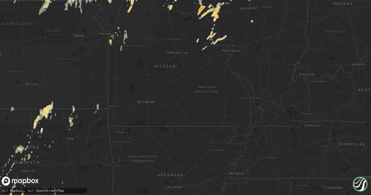
Hail Map in Texas on May 11, 2011
Get this storm
May 11 map
$229
one time, instant access
Download today. No call, no setup
Keep the $229
Bought the map and want the full workflow? Apply the entire $229 to a subscription within 7 days. None of it is wasted.
Every map, not just this one
This buys you this map. Subscription and you get every map we run, in the markets you choose from a few cities to whole states to nationwide. Plus real-time alerts the moment a storm fires.
Contact data
Name, contact info, occupancy, even credit band for addresses in the footprint. You go from where it hit to who to call.
Become the source they trust
Unlimited branding weather history reports on demand. You already have the documented answer ready for the property owner, and you are the one who showed up with it.
Property data and RoofTrace estimates
Pull up any address you have got, its value and the exact code rules for that jurisdiction, straight from One Click Code. Then RoofTrace estimates the squares, pitch, and roof value, priced the way you price.
Storm reports in Texas
Texas
| Date | Description |
|---|---|
| 05/11/20116:55 PM CDT | Golf ball size hail reported 11 miles south of mason. Sheiffs office reports a vehicle lost control due to the hail but no injuries were reported. |
| 05/11/20116:45 PM CDT | Ping pong ball size hail and 1.90 inches of rainfall in 30 minutes. |
| 05/11/20115:55 PM CDT | A local report indicates 65 MPH wind near MOFFAT |
| 05/11/20115:30 PM CDT | Large hail near oatmeal along with an inch of rainfall in less than 30 miniutes. |
| 05/11/20115:20 PM CDT | W side of fort hood |
| 05/11/20115:20 PM CDT | W side of fort hood |
| 05/11/20114:58 PM CDT | Quarter size hail reported 3 miles nw of mason |
| 05/11/20114:35 PM CDT | Large tree branches blown down... Roof blown off a boat deck |
| 05/11/20114:31 PM CDT | Golf ball size hail reported 3 miles nw of mason. |
| 05/11/20114:17 PM CDT | Golf ball size hail reported in mason. |
| 05/11/20113:39 PM CDT | A local report indicates 1.00 inch wind near LLANO |
| 05/11/20113:12 PM CDT | A local report indicates 1.75 inch wind near QUEMADO |
| 05/11/20112:55 PM CDT | 62 mph gust measured at sherman/denison airport |
| 05/11/20112:50 PM CDT | Pea to 1 hail and heavy rain |
| 05/11/20112:45 PM CDT | Trailer home damaged and automobile overturned |
| 05/11/20112:41 PM CDT | A local report indicates 58 MPH wind near COLLINSVILLE |
| 05/11/20112:40 PM CDT | Partial roof off a residence. Suburban vehicle was flipped on its side and 8 outbuildings destroyed. Reports were on the 500 block of crow road. |
| 05/11/20112:37 PM CDT | Damage to barns and outbuildings 1 se of gainesville |
| 05/11/20112:35 PM CDT | 5 miles w of sherman |
| 05/11/20112:33 PM CDT | 65 mph wind gust measured in irving |
| 05/11/20112:15 PM CDT | Photos relayed through media |
| 05/11/20112:10 PM CDT | Intersection of roanoke and knox in north keller |
| 05/11/20112:04 PM CDT | Measured 50 kts at nws office in fort worth |
| 05/11/20111:55 PM CDT | A 30'x15' post barn was destroyed with the debris scattered approximately 1/4 mile to the northeast. The posts of the barn were ripped out of the ground. |
| 05/11/20111:55 PM CDT | Some quarter size hail was reported in the mullin area |
| 05/11/20111:55 PM CDT | Roof off home and power poles snapped on fm 2264 approx. 3 to 4 mi west of denton county line. |
| 05/11/20111:54 PM CDT | Tractor trailers blown off road at the intersection of hwy 287 and fm 407; estimated 65 mph winds. |
| 05/11/20111:45 PM CDT | Restaurant sign damage along 287 in decatur; time estimated by radar |
| 05/11/20111:42 PM CDT | Power lines down at fm 2123 and sh 114 in bridgeport |
| 05/11/20111:35 PM CDT | Mobile home blown off foundation; out buildings blown into trees; intersection of cr 1655 and fm 1810 |
| 05/11/20111:35 PM CDT | Few tree limbs down and damage to the roof of a barn. |
| 05/11/20111:33 PM CDT | A local report indicates 66 MPH wind near 1 N SPRINGTOWN |
| 05/11/20111:19 PM CDT | Bethel road and horseshoe bend road |
| 05/11/20111:18 PM CDT | Hail was at least the size of quarters |
| 05/11/20111:00 PM CDT | Report of cars blown off the road 10 mi n of stephenville on hwy 108 |
| 05/11/201112:20 PM CDT | Wind gusts estimated between 60 and 70 mph on the southwest side of possum kingdom lake |
| 05/11/201112:20 PM CDT | Quarter size hail reported on the southwest side of possum kingdom lake |
| 05/11/201112:04 PM CDT | A local report indicates 1.00 inch wind near 13 NW KERR WILDLIFE MGM |
| 05/11/201111:15 AM CDT | Report from ktxs employee |
| 05/11/201110:15 AM CDT | Hail just under the size of golf balls and winds of 50-60 mph 4 miles north of the concho and runnels county line on u.s. Highway 83. |
| 05/11/201110:05 AM CDT | Quarter size hail at krun studios in south ballinger. |
| 05/11/20116:45 AM CDT | A local report indicates 1.00 inch wind near 10 N ALAMO VILLAGE |
| 05/11/20115:50 AM CDT | A local report indicates 1.00 inch wind near CARTA VALLEY |
| 05/11/20115:25 AM CDT | A local report indicates 1.00 inch wind near 10 SW CARTA VALLEY |
| 05/11/20114:30 AM CDT | Devils river st pk |
| 05/10/201110:56 PM CDT | Golf ball size hail along with heavy rain. |
| 05/10/201110:42 PM CDT | A local report indicates 1.00 inch wind near 1 N BARTLETT |
| 05/10/201110:42 PM CDT | A local report indicates 60 MPH wind near 1 N BARTLETT |
| 05/10/201110:15 PM CDT | One inch hail and wind gusts to 40 mph. |
| 05/10/201110:15 PM CDT | Half inch to one inch size hail and strong winds. 1.20 inches of rainfall. |
| 05/10/201110:15 PM CDT | 10 inch diameter trees downed |
| 05/10/201110:09 PM CDT | Half inch to inch size hail in jarrell |
| 05/10/20119:41 PM CDT | Quarter size hail |
| 05/10/20119:10 PM CDT | A local report indicates 65 MPH wind near KILLEEN |
| 05/10/20119:00 PM CDT | 18-24 inch in diameter tree blown down on 18th street in killeen |
| 05/10/20118:40 PM CDT | Reported 1.6nm ene of kgrk |
| 05/10/20118:23 PM CDT | A local report indicates 1.00 inch wind near LORENA |
| 05/10/20118:15 PM CDT | A local report indicates 1.25 inch wind near MOODY |
| 05/10/20118:08 PM CDT | Quarter sized hail in moody |
| 05/10/20117:20 PM CDT | Half inch to golfball size hail and heavy rain. |
| 05/10/20117:20 PM CDT | Nickel to near quarter size hail. |
All States Impacted by Hail Map on May 11, 2011
Cities Impacted by Hail Map on May 11, 2011
- Marble Falls, TX
- Johnson City, TX
- Llano, TX
- Horseshoe Bay, TX
- Round Mountain, TX
- Williamstown, MO
- Kahoka, MO
- Saint Patrick, MO
- Maple City, MI
- Chase, KS
- Raymond, KS
- Madison, WI
- Vona, CO
- Anabel, MO
- Atlanta, MO
- Macon, MO
- Macomb, IL
- Wellington, MO
- Bates City, MO
- Holden, MO
- Napoleon, MO
- Odessa, MO
- Northport, MI
- Plymouth, OH
- Shiloh, OH
- Audubon, IA
- Temple, TX
- Bellevue, TX
- Morrisonville, IL
- Burlington, CO
- Elgin, OK
- Mesick, MI
- Alva, OK
- Wahoo, NE
- Ithaca, NE
- Barnard, KS
- Kansas, OH
- Wayne, OH
- Fostoria, OH
- Risingsun, OH
- Egg Harbor, WI
- Peshtigo, WI
- Marinette, WI
- Sturgeon Bay, WI
- Elk Mound, WI
- Colfax, WI
- Falls City, NE
- Horton, KS
- Hiawatha, KS
- Fairview, KS
- Eldorado, TX
- Palmyra, WI
- Dousman, WI
- Burlington, WI
- Dexter, MI
- Chelsea, MI
- Ann Arbor, MI
- Krakow, WI
- Abrams, WI
- Oconto Falls, WI
- Little Suamico, WI
- Oconto, WI
- Lena, WI
- Gillett, WI
- Cecil, WI
- Calumet, OK
- Okarche, OK
- El Reno, OK
- Britton, MI
- Westmoreland, KS
- Rapid City, MI
- Alden, MI
- Macedonia, IA
- Ludington, MI
- Melvin, TX
- Old Monroe, MO
- Golden Eagle, IL
- Wentzville, MO
- Grafton, IL
- Brussels, IL
- O'Fallon, MO
- Winfield, MO
- Skiatook, OK
- Paw Paw, MI
- Mattawan, MI
- Kiel, WI
- Catawba, WI
- Prentice, WI
- Kennan, WI
- Eden, TX
- La Plata, MO
- Mount Sterling, IL
- New Salem, IL
- New London, MO
- Rockport, IL
- Baylis, IL
- Versailles, IL
- Chambersburg, IL
- Hull, IL
- Pittsfield, IL
- Nebo, IL
- Beardstown, IL
- Pleasant Hill, IL
- Perry, IL
- Barry, IL
- New Canton, IL
- Frankford, MO
- Kinderhook, IL
- Griggsville, IL
- Arenzville, IL
- Clarence, MO
- Olsburg, KS
- Manhattan, KS
- Goldthwaite, TX
- Pottsville, TX
- Hamilton, TX
- San Saba, TX
- Mullin, TX
- Winfield, KS
- Burden, KS
- Pound, WI
- Tomah, WI
- Wilton, WI
- Warrens, WI
- North Aurora, IL
- Aurora, IL
- Batavia, IL
- Tippecanoe, IN
- Mentone, IN
- Warsaw, IN
- Bourbon, IN
- Etna Green, IN
- Guthrie, OK
- Weldon, IA
- Garden Grove, IA
- Elk Creek, VA
- Independence, VA
- Joliet, IL
- Lockport, IL
- Prague, NE
- Del Rio, TX
- Comstock, TX
- Mchenry, IL
- Fox Lake, IL
- Spring Grove, IL
- Sterling, NE
- Tecumseh, NE
- Onondaga, MI
- Rives Junction, MI
- Holland, MI
- Fullerton, NE
- Sheridan, MO
- Clarinda, IA
- Morrill, KS
- Sabetha, KS
- Dryden, TX
- Salado, TX
- Killeen, TX
- Jarrell, TX
- Belton, TX
- Bartlett, TX
- Florence, TX
- Georgetown, TX
- Independence, KS
- Cainsville, MO
- Crystal Lake, IL
- Woodstock, IL
- Channahon, IL
- Mereta, TX
- Miles, TX
- San Angelo, TX
- Eola, TX
- Gilman City, MO
- Junction, TX
- Wimberley, TX
- Blanco, TX
- Ashland, OH
- Greenwich, OH
- Mansfield, OH
- Wymore, NE
- Lorena, TX
- Bruceville, TX
- Hewitt, TX
- McGregor, TX
- Moody, TX
- Waco, TX
- Voss, TX
- Ruthven, IA
- Terril, IA
- Dickens, IA
- Foster, OK
- Duncan, OK
- Marlow, OK
- Comanche, OK
- Loco, OK
- Rhinelander, WI
- Brackettville, TX
- Henrietta, TX
- Callao, MO
- Ulysses, NE
- Crivitz, WI
- Adrian, MI
- Palmyra, MI
- Jasper, MI
- Sauk City, WI
- Mazomanie, WI
- Russell, KS
- Great Bend, KS
- Hoisington, KS
- Olmitz, KS
- Lineville, IA
- Princeton, MO
- Mercer, MO
- Millbury, OH
- Walbridge, OH
- Oregon, OH
- Perrysburg, OH
- Harbor View, OH
- Toledo, OH
- Northwood, OH
- Yukon, OK
- Mustang, OK
- Maple City, KS
- Dexter, KS
- Cedar Vale, KS
- Kaw City, OK
- Burbank, OK
- Ponca City, OK
- Shidler, OK
- Newkirk, OK
- Bellwood, NE
- Chillicothe, TX
- Odell, TX
- Vernon, TX
- Christoval, TX
- Hartland, WI
- Fort Worth, TX
- Lakemont, GA
- Elsberry, MO
- Silex, MO
- Troy, MO
- Hawk Point, MO
- Foley, MO
- Springfield, NE
- Louisville, NE
- Murdock, NE
- Wheeler, TX
- Briscoe, TX
- Morris, IL
- Santa Anna, TX
- Knox, IN
- Northbrook, IL
- Highland Park, IL
- Glencoe, IL
- Kingfisher, OK
- Mason, TX
- Osceola, NE
- Stromsburg, NE
- Ridgeway, MO
- Bethany, MO
- Eagleville, MO
- Quemado, TX
- Coleman, WI
- Porterfield, WI
- La Valle, WI
- Lyndon Station, WI
- Dane, WI
- Deforest, WI
- Camp Douglas, WI
- Manistee, MI
- Chippewa Falls, WI
- Eau Claire, WI
- Dowling, MI
- Hastings, MI
- San Jose, IL
- Delavan, IL
- Mason City, IL
- Green Valley, IL
- Easton, IL
- Petersburg, IL
- Oakford, IL
- Quincy, IL
- Payson, IL
- Hayes Center, NE
- Palisade, NE
- Wauneta, NE
- Albany, WI
- Farragut, IA
- Buda, TX
- Driftwood, TX
- San Marcos, TX
- Kyle, TX
- Mountain Rest, SC
- Westminster, SC
- Long Creek, SC
- Walhalla, SC
- Brownwood, TX
- Early, TX
- Blanket, TX
- Zephyr, TX
- Polk, NE
- Bradshaw, NE
- Sparta, WI
- Duke, OK
- Kingsland, TX
- Fredericksburg, TX
- Willow City, TX
- Nelson, NE
- Weston, NE
- Ceresco, NE
- Harrietta, MI
- Welch, OK
- Sweetwater, OK
- Athelstane, WI
- Genoa, NE
- Silver Creek, NE
- Clarks, NE
- Weatherford, OK
- Thomas, OK
- Granite, OK
- Jeromesville, OH
- Imogene, IA
- Shenandoah, IA
- Essex, IA
- Bedford, IA
- Nodaway, IA
- New Market, IA
- Creston, IA
- Gravity, IA
- Sharpsburg, IA
- Prescott, IA
- Carbon, IA
- Villisca, IA
- Corning, IA
- Stanton, IA
- Red Oak, IA
- Lenox, IA
- Paint Rock, TX
- Rowena, TX
- Reydon, OK
- Crawford, OK
- Cedar Rapids, NE
- Cisco, TX
- Rising Star, TX
- Cheyenne, OK
- Sutton, NE
- Geneva, NE
- Fairmont, NE
- Grafton, NE
- Charlotte, MI
- Vermillion, SD
- Wilmington, IL
- Arcadia, OK
- Hopkins, MI
- Dorr, MI
- Tiffin, OH
- Bradner, OH
- West Millgrove, OH
- Red Rock, OK
- Marland, OK
- Tonkawa, OK
- Tampico, IL
- Murray, NE
- Weeping Water, NE
- Nehawka, NE
- Rocksprings, TX
- Barksdale, TX
- Plainville, IL
- Hannibal, MO
- Buckholts, TX
- Holland, TX
- Rogers, TX
- Marlin, TX
- Whiting, IA
- Salix, IA
- Sloan, IA
- Climbing Hill, IA
- Hornick, IA
- Bronson, IA
- Winnebago, NE
- Hartley, IA
- Schaumburg, IL
- Elk Grove Village, IL
- Sonora, TX
- New Hampton, MO
- Albany, MO
- Martinsville, MO
- Fort Hood, TX
- Spring Hill, KS
- Caddo, TX
- Breckenridge, TX
- Rock Port, MO
- Stanley, WI
- Springtown, TX
- Mead, NE
- Oneida, KS
- Sheffield, IL
- Saint Edward, NE
- Chico, TX
- Sunset, TX
- Mcfarland, WI
- Sun Prairie, WI
- Verona, WI
- Milford, NE
- Pleasant Dale, NE
- Seward, NE
- Waurika, OK
- Watertown, WI
- Alto, MI
- Fall Creek, WI
- Altoona, WI
- Castell, TX
- Buchanan Dam, TX
- Doss, TX
- Elgin, IL
- Maple Park, IL
- Hampshire, IL
- Gilberts, IL
- Huntley, IL
- Carpentersville, IL
- Algonquin, IL
- Lake In The Hills, IL
- Dundee, IL
- Crockett, TX
- Groveton, TX
- Pennington, TX
- Dodge City, KS
- Green Castle, MO
- Green City, MO
- Three Oaks, MI
- Rolling Prairie, IN
- New Carlisle, IN
- La Porte, IN
- Galien, MI
- Rush Center, KS
- Albert, KS
- Otis, KS
- Stoughton, WI
- Oregon, WI
- Jefferson, WI
- Cambridge, WI
- Lake Mills, WI
- Johnson Creek, WI
- Deerfield, WI
- Helenville, WI
- Cottage Grove, WI
- Waterloo, WI
- Fort Atkinson, WI
- Millersburg, OH
- Fresno, OH
- Kansas City, MO
- Ninnekah, OK
- Rush Springs, OK
- Walters, OK
- Temple, OK
- Oskaloosa, IA
- Benton, IA
- Campobello, SC
- Bremen, IN
- Smithville, OK
- Watson, OK
- Elmo, MO
- Burlington Junction, MO
- Ballinger, TX
- Talpa, TX
- Coleman, TX
- Hawarden, IA
- Stephenson, MI
- Randall, KS
- Jewell, KS
- Frankfort, KS
- Argos, IN
- Hardy, NE
- Byron, NE
- Deshler, NE
- Bartlesville, OK
- Ochelata, OK
- Ramona, OK
- Bridgeport, TX
- Nelson, WI
- York, NE
- Hampton, NE
- Barnes, KS
- Wellington, OH
- Carleton, NE
- Hebron, NE
- Shickley, NE
- Silver City, IA
- Malvern, IA
- Glenwood, IA
- Wellsville, KS
- Rantoul, KS
- Edgerton, KS
- Williamston, MI
- Crete, NE
- Scottville, MI
- Stockbridge, MI
- Hordville, NE
- La Harpe, IL
- Blandinsville, IL
- Bertram, TX
- Chesterton, IN
- Valparaiso, IN
- Mineral Wells, TX
- Alvord, TX
- Minooka, IL
- Shorewood, IL
- Plainfield, IL
- Craig, MO
- Forest City, MO
- Carlton, TX
- Olney, TX
- Richland Springs, TX
- Rochelle, TX
- Johnstown, NE
- Scotland, TX
- Edina, MO
- Novelty, MO
- Taylor, NE
- Columbus, NC
- Cashion, OK
- Tamassee, SC
- West Union, SC
- Frontenac, KS
- Pittsburg, KS
- Gould, OK
- Garland, NE
- Brady, TX
- Hamburg, IA
- Sidney, IA
- Emerson, IA
- Randolph, IA
- Westboro, MO
- Northboro, IA
- Tarkio, MO
- Delphos, KS
- Lawton, OK
- Jacksboro, TX
- Garden City, MO
- Pleasant Hill, MO
- Kingsville, MO
- Tremont, IL
- Neodesha, KS
- Elk City, KS
- Leonard, MO
- Wausaukee, WI
- Pembine, WI
- Amberg, WI
- Dunbar, WI
- Daggett, MI
- Lane, OK
- Spickard, MO
- King City, MO
- Luther, MI
- Justin, TX
- Ponder, TX
- Coldwater, MI
- Minco, OK
- Anadarko, OK
- Pocasset, OK
- Salem, SC
- Atwood, KS
- Denver, MO
- Gentry, MO
- Helena, OH
- Gibsonburg, OH
- Balko, OK
- Oak Lawn, IL
- Palos Hills, IL
- Burbank, IL
- Willow Springs, IL
- Justice, IL
- Bridgeview, IL
- Worth, IL
- Palos Park, IL
- Chicago Ridge, IL
- Hickory Hills, IL
- Lemont, IL
- Willowbrook, IL
- Robinson, KS
- Fairfax, MO
- White Cloud, KS
- Oregon, MO
- Mound City, MO
- Rulo, NE
- Maitland, MO
- Fillmore, MO
- Winters, TX
- Wolbach, NE
- Graford, TX
- Graham, TX
- Minneapolis, KS
- Lindsay, OK
- Quanah, TX
- Table Rock, NE
- Johnson, NE
- Elk Creek, NE
- Cook, NE
- Lawrence, MI
- Percival, IA
- Gregory, MI
- Fowlerville, MI
- Webberville, MI
- Mundelein, IL
- Vernon Hills, IL
- Unionville, MO
- Crowell, TX
- Pewaukee, WI
- Delafield, WI
- Nashotah, WI
- Landrum, SC
- Tryon, NC
- Franklin, TX
- Hearne, TX
- Plymouth, IN
- Culver, IN
- North Judson, IN
- Hamlet, IN
- Grovertown, IN
- Nekoma, KS
- Grandview, MO
- Crescent, OK
- Prospect Heights, IL
- Mount Prospect, IL
- Glenview, IL
- Wallace, NE
- Staplehurst, NE
- Surprise, NE
- Bangs, TX
- Brookesmith, TX
- Wautoma, WI
- Coloma, WI
- Westfield, WI
- Wright, KS
- Waunakee, WI
- Rosebud, TX
- Lott, TX
- Odell, NE
- Bremen, KS
- Marysville, KS
- Kirksville, MO
- Argonne, WI
- Stanberry, MO
- Plattsmouth, NE
- Marion, MI
- Nolanville, TX
- Harker Heights, TX
- Briggs, TX
- Benedict, KS
- Altoona, KS
- Thayer, KS
- Chanute, KS
- Belleville, WI
- Brooklyn, WI
- Dewey, OK
- Elliott, IA
- Pollock, MO
- Lucerne, MO
- Newtown, MO
- Shepherd, TX
- Livingston, TX
- Goodrich, TX
- Arkansas City, KS
- Wayland, MI
- Shelbyville, MI
- Medicine Park, OK
- Schuyler, NE
- Hext, TX
- Menard, TX
- Durand, WI
- Menomonie, WI
- Fontanelle, IA
- Tupelo, OK
- Stonewall, OK
- Friendship, WI
- Plainfield, WI
- Hancock, WI
- Lincoln, KS
- Almond, WI
- Wild Rose, WI
- Eagle, MI
- Portland, MI
- Pinckney, MI
- Howell, MI
- Clarkson, NE
- Leigh, NE
- Miltonvale, KS
- Union Star, MO
- Darlington, MO
- Wellston, MI
- Brethren, MI
- Free Soil, MI
- Oglesby, TX
- Gatesville, TX
- Kempner, TX
- Lampasas, TX
- Copperas Cove, TX
- Burnet, TX
- Caledonia, MI
- Middleville, MI
- Tescott, KS
- Leon, IA
- Mondovi, WI
- Skidmore, MO
- Kendall, WI
- Beaver, OK
- Decatur, TX
- Troutdale, VA
- Mouth Of Wilson, VA
- Powersville, MO
- Belleville, MI
- Ypsilanti, MI
- Mulliken, MI
- Frederick, OK
- Kellerton, IA
- Merrimac, WI
- Baraboo, WI
- Humeston, IA
- Liberty, IL
- Edmond, OK
- Ottawa Lake, MI
- Gleason, WI
- Glen Flora, WI
- Tony, WI
- Ogema, WI
- Brantwood, WI
- Delton, MI
- Toccoa, GA
- Brevard, NC
- Rosman, NC
- Lake Toxaway, NC
- Sunset, SC
- Tiger, GA
- Clarkesville, GA
- Harris, MO
- Milan, MO
- Michigan City, IN
- Westville, IN
- Hobart, IN
- Woodway, TX
- Washington, KS
- Idalia, CO
- Orlando, FL
- Phillips, WI
- Bostic, NC
- Ellenboro, NC
- Novice, TX
- Lawn, TX
- Goldsboro, TX
- Liberty, NE
- Oketo, KS
- Hamilton, IL
- Telephone, TX
- Allerton, IA
- Corydon, IA
- Jetmore, KS
- Amherst, WI
- Dewitt, MI
- Cherokee, TX
- Sterling City, TX
- Keller, TX
- Tomahawk, WI
- Gallatin, MO
- Jameson, MO
- Oconomowoc, WI
- Sussex, WI
- Colgate, WI
- Bridgewater, IA
- Liberty Hill, TX
- Lodi, WI
- Jamesport, MO
- Morse Bluff, NE
- Colon, NE
- Malmo, NE
- Madison, NE
- Indiahoma, OK
- Ranger, TX
- Strawn, TX
- Wann, OK
- Caney, KS
- Copan, OK
- Speedwell, VA
- Rural Retreat, VA
- Newcastle, TX
- Columbus, NE
- Hamlin, IA
- Exira, IA
- Hazelhurst, WI
- Tripoli, WI
- Sweetwater, TX
- Nocona, TX
- Mulhall, OK
- Chilton, TX
- Eddy, TX
- Durand, IL
- Brodhead, WI
- Davis, IL
- Mankato, KS
- Moulton, IA
- Unionville, IA
- Centerville, IA
- Udell, IA
- University Park, IA
- Eddyville, IA
- Spearville, KS
- Ford, KS
- Eastland, TX
- Greenville, TX
- Fountain, MI
- Branch, MI
- Rutherfordton, NC
- Oklahoma City, OK
- Lucas, KS
- Black River Falls, WI
- Shannon City, IA
- Gainesville, TX
- Bern, KS
- Byron Center, MI
- Hamilton, MI
- Allegan, MI
- Hudsonville, MI
- Zeeland, MI
- Perry, OK
- Orlando, OK
- Momence, IL
- Utica, NE
- Gresham, NE
- Waco, NE
- Syracuse, NE
- Unadilla, NE
- Nebraska City, NE
- Dunbar, NE
- Webber, KS
- Formoso, KS
- Bowie, TX
- Lac Du Flambeau, WI
- Finley, OK
- Moyers, OK
- Antlers, OK
- Richmond, IL
- Pacific Junction, IA
- Amity, MO
- Goff, KS
- Soldier, KS
- Concordia, KS
- Aurora, KS
- Clyde, KS
- Eaton Rapids, MI
- Glasco, KS
- Garnett, KS
- Adams, NE
- Cortland, NE
- Coin, IA
- Blanchard, IA
- Piedmont, KS
- Dorchester, NE
- Conway Springs, KS
- Viola, KS
- Hinckley, IL
- Avoca, NE
- Otoe, NE
- Yorkville, IL
- Rib Lake, WI
- Breckenridge, MO
- Hamilton, MO
- Suring, WI
- Palmer, NE
- Central City, NE
- Archer, NE
- Binger, OK
- Grand Ledge, MI
- Dillard, GA
- Cazenovia, WI
- Osceola, IA
- Murray, IA
- Homer, NE
- Luther, OK
- Blakesburg, IA
- Drakesville, IA
- Ottumwa, IA
- Valera, TX
- Beatrice, NE
- Fairbury, NE
- Alcester, SD
- Hudson, SD
- Stringtown, OK
- Creston, NE
- Spicewood, TX
- Clyde, TX
- Luray, KS
- New Glarus, WI
- Kennard, TX
- Forestburg, TX
- Saint Jo, TX
- Muenster, TX
- Albion, MI
- Homer, MI
- Monmouth, IL
- Addison, IL
- Itasca, IL
- Wood Dale, IL
- Royal, IA
- Everly, IA
- Spencer, IA
- Bryson, TX
- Bruno, NE
- Cache, OK
- Moville, IA
- Canute, OK
- Three Lakes, WI
- Harper, TX
- Comanche, TX
- Voca, TX
- Hennessey, OK
- Evansville, WI
- Janesville, WI
- Poolville, TX
- Weatherford, TX
- Whitt, TX
- Buckner, MO
- Baird, TX
- Edgar, NE
- Grand Island, NE
- Chapman, NE
- Pawnee, OK
- Irons, MI
- Parma, MI
- Ellsworth, KS
- Wilson, KS
- Sylvan Grove, KS
- Nashville, MI
- Vermontville, MI
- Greenleaf, KS
- La Belle, MO
- Benzonia, MI
- Frankfort, MI
- Grand Ridge, IL
- Marseilles, IL
- Ransom, IL
- Trenton, MO
- Saint Charles, IL
- Wayne, IL
- South Elgin, IL
- Coal City, IL
- Valparaiso, NE
- Concord, MI
- Carbon, TX
- Avon, IL
- Virginia, IL
- Waukegan, IL
- Zion, IL
- Helena, MO
- Beverly, KS
- Watonga, OK
- Sylva, NC
- Roff, OK
- Tustin, MI
- McBain, MI
- Leroy, MI
- Cadillac, MI
- Cornell, WI
- Whitewater, WI
- Lambertville, MI
- Temperance, MI
- Maitland, FL
- Winter Park, FL
- Wisner, NE
- Seneca, KS
- Smithland, IA
- Fort Pierce, FL
- Grassy Creek, NC
- Geary, OK
- Waterville, KS
- Hanover, KS
- Exline, IA
- Cincinnati, IA
- Blackstone, IL
- Kinsman, IL
- New Lisbon, WI
- Jansen, NE
- Stratton, CO
- Stanton, NE
- Lake, MI
- Harrison, MI
- Loudonville, OH
- Bluff City, KS
- Tow, TX
- Valley Spring, TX
- Lake Geneva, WI
- Elkhorn, WI
- Marthasville, MO
- Warrenton, MO
- Chattanooga, OK
- Loveland, OK
- Mangum, OK
- Olustee, OK
- Kanorado, KS
- Bellevue, NE
- Papillion, NE
- Erick, OK
- Ursa, IL
- Mendon, IL
- Fowler, IL
- Pender, NE
- Plymouth, NE
- De Witt, NE
- Palmer, KS
- Lindsay, NE
- Maxwell, NE
- Wonder Lake, IL
- Hebron, IL
- New Florence, MO
- Lakeville, OH
- Elkhart Lake, WI
- Custer, MI
- Wilber, NE
- Morrowville, KS
- Afton, IA
- Tennessee, IL
- Plymouth, IL
- Willow, OK
- Elkhart, TX
- Glencoe, OK
- Stillwater, OK
- Evart, MI
- Corrigan, TX
- Oberlin, KS
- Moscow Mills, MO
- Groesbeck, TX
- Gracemont, OK
- Clayton, IL
- Art, TX
- Clayton, GA
- Loraine, TX
- Roscoe, TX
- Onekama, MI
- Bear Lake, MI
- Union City, OK
- Seibert, CO
- Cameron, TX
- Gause, TX
- McCool Junction, NE
- Galesburg, MI
- Norfolk, NE
- Raymore, MO
- Belton, MO
- Hurdland, MO
- Elroy, WI
- Mauston, WI
- Linn, KS
- Waupaca, WI
- Dresden, KS
- Dawson, NE
- Du Bois, NE
- Humboldt, NE
- Salem, NE
- Wolfe City, TX
- Necedah, WI
- Eureka, KS
- Cushing, OK
- Braymer, MO
- Lock Springs, MO
- Crandon, WI
- Pawhuska, OK
- Stanfield, NC
- Midland, NC
- Monroe, NC
- Waterford, WI
- Union Grove, WI
- Berger, MO
- Beloit, KS
- Courtland, KS
- Lorimor, IA
- Manchester, OK
- Anthony, KS
- Athens, IL
- Decatur, IA
- Dublin, TX
- Shelbina, MO
- Grandville, MI
- Jenison, MI
- Grand Rapids, MI
- Wyoming, MI
- Paola, KS
- Eudora, KS
- Baldwin City, KS
- Bison, KS
- Marshall, WI
- Shawano, WI
- Ringwood, IL
- Colby, KS
- Hustler, WI
- Gorman, TX
- Shreve, OH
- Clearfield, IA
- Hatfield, MO
- Blythedale, MO
- Chillicothe, MO
- Agenda, KS
- Belleville, KS
- Independence, MO
- Genoa, OH
- Curtice, OH
- Grapeland, TX
- Douglas, NE
- Firth, NE
- Filley, NE
- Blue Springs, NE
- Hickman, NE
- Bennet, NE
- Pickrell, NE
- Crab Orchard, NE
- Rattan, OK
- Thayer, IA
- Ellston, IA
- Evant, TX
- Gouldbusk, TX
- Sergeant Bluff, IA
- Fort McKavett, TX
- Leslie, MI
- Galesburg, IL
- Davidson, OK
- Malcolm, NE
- Raymond, NE
- Monroe, WI
- Juda, WI
- Watson, MO
- Shamrock, TX
- Holcombe, WI
- Conrath, WI
- Ryan, OK
- Marquette, NE
- Henderson, NE
- Stroud, OK
- Normangee, TX
- Girard, KS
- Burr, NE
- Saint Cloud, FL
- Foristell, MO
- North Manchester, IN
- Seagoville, TX
- Forney, TX
- Tipton, KS
- Osborne, KS
- Elkhart, IL
- Windthorst, TX
- Greenfield, IA
- Denton, TX
- Stark, KS
- Cross Plains, TX
- Milligan, NE
- Kaleva, MI
- Copemish, MI
- Pelican Lake, WI
- Fredonia, TX
- Dallas City, IL
- Lawton, IA
- Sioux City, IA
- Pawnee City, NE
- Lewiston, NE
- Burchard, NE
- Steinauer, NE
- Poynette, WI
- Dodge, NE
- Beemer, NE
- Howells, NE
- West Point, NE
- Hayesville, OH
- Big Prairie, OH
- Perrysville, OH
- Shelby, OH
- Dwight, NE
- Baileyville, KS
- Axtell, KS
- Minneola, KS
- Chickasha, OK
- Pattonsburg, MO
- Dekalb, IL
- Ingleside, IL
- Elburn, IL
- Grant City, MO
- Worth, MO
- Harrold, TX
- Henderson, IA
- Durham, OK
- Thurman, IA
- Portage, IN
- Verdon, NE
- Centralia, KS
- Wichita, KS
- Colwich, KS
- Goddard, KS
- Maize, KS
- Bunker Hill, KS
- Bushton, KS
- Holyrood, KS
- Claflin, KS
- Burkett, TX
- Abingdon, IL
- Maquon, IL
- Riesel, TX
- New Virginia, IA
- Phillips, NE
- Garden City, TX
- Westbrook, TX
- Bucklin, KS
- Arlington, WI
- Rio, WI
- Culbertson, NE
- Diagonal, IA
- Argyle, TX
- Duncan, NE
- Monroe, NE
- Jackson, MI
- David City, NE
- Burdett, KS
- Olivet, MI
- Bellevue, MI
- Harshaw, WI
- Dwight, IL
- Diller, NE
- La Crosse, KS
- Larned, KS
- Moran, TX
- Kingston, OK
- Glen Ellyn, IL
- Glendale Heights, IL
- Lombard, IL
- Lamoni, IA
- Orrick, MO
- Excelsior Springs, MO
- Highlands, NC
- Cedar, MI
- Springfield, WI
- Sparta, MI
- London Mills, IL
- Morrison, OK
- Park Falls, WI
- Boyd, WI
- Humboldt, KS
- Colchester, IL
- Muir, MI
- Fenwick, MI
- Ionia, MI
- Ruskin, NE
- Republic, KS
- Norton, TX
- Barrington, IL
- Cary, IL
- Diboll, TX
- Lovelady, TX
- Trinity, TX
- Crockett, VA
- Crumpler, NC
- Piney Creek, NC
- Wytheville, VA
- Springport, MI
- Wright City, MO
- Ringgold, TX
- Hartington, NE
- Newcastle, NE
- Wynot, NE
- Argonia, KS
- Freeport, KS
- Knox City, MO
- Wonewoc, WI
- Florence, WI
- Manitowoc, WI
- Valders, WI
- Newton, WI
- Brainard, NE
- Riverton, IA
- Lansing, NC
- Libertyville, IL
- Grayslake, IL
- Gurnee, IL
- Berkey, OH
- Blissfield, MI
- Metamora, OH
- Thornton, TX
- Kosse, TX
- Elmer, OK
- Bellevue, OH
- Columbus, KS
- Chetopa, KS
- Danbury, NE
- Sidney, TX
- Milton, KS
- Garden Plain, KS
- Union, NE
- Humphreys, MO
- Plainwell, MI
- Hinton, OK
- Sheridan, MI
- Bruning, NE
- Strang, NE
- Davenport, NE
- Burkburnett, TX
- Randlett, OK
- Wichita Falls, TX
- Bassett, NE
- Bryan, TX
- Apache, OK
- Battle Creek, MI
- Sanger, TX
- Ringling, OK
- Wallace, MI
- Cedar Springs, MI
- Perrin, TX
- Home, KS
- Columbus, WI
- Jones, OK
- Hawkins, WI
- Hopedale, IL
- Green Springs, OH
- Clay Center, KS
- Jerseyville, IL
- Pentwater, MI
- Arkdale, WI
- Broaddus, TX
- Orient, IA
- Bethune, CO
- Mart, TX
- Stuart, IA
- Bee, NE
- Clatonia, NE
- Swanton, NE
- Endicott, NE
- Antioch, IL
- Emmetsburg, IA
- Graettinger, IA
- Fremont, OH
- Troy, TX
- Coshocton, OH
- Calvin, OK
- Stuart, OK
- Aurora, NE
- Granger, TX
- Leander, TX
- Priddy, TX
- Little River Academy, TX
- Pontotoc, TX
- Mountain Home, TX
- Bluffton, TX
- Kalamazoo, MI
- Brashear, MO
- Jasper, TX
- Orange City, IA
- Longford, KS
- Honor, MI
- Lake Tomahawk, WI
- Carnegie, OK
- Miami, OK
- Evanston, IL
- Wilmette, IL
- Skokie, IL
- May, TX
- Carter, OK
- Sentinel, OK
- Lone Wolf, OK
- Scammon, KS
- Iola, KS
- Middleton, WI
- Sullivan, WI
- Sheldon, WI
- Elmwood, NE
- Denton, NE
- Greeley, KS
- Wisconsin Dells, WI
- Grand Marsh, WI
- Irma, WI
- Omaha, NE
- Gretna, NE
- Cedar Creek, NE
- Manley, NE
- Aledo, TX
- Colmesneil, TX
- Woodville, TX
- Uniontown, KS
- Spring Arbor, MI
- Horton, MI
- Seneca, IL
- Axtell, TX
- Conklin, MI
- South Sioux City, NE
- Deerfield, IL
- Perryton, TX
- Blue Springs, MO
- Altus, OK
- Minocqua, WI
- Cyril, OK
- Medford, WI
- Talmage, NE
- Virginia, NE
- Panama, NE
- Brock, NE
- Dakota City, NE
- Rogers, NE
- Era, TX
- Orfordville, WI
- Mount Horeb, WI
- Humphrey, NE
- Valley View, TX
- Kimballton, IA
- Sioux Center, IA
- Atoka, OK
- Boswell, OK
- Vickery, OH
- Clyde, OH
- Cedar Bluffs, NE
- Martin, OH
- Laurel Springs, NC
- Sparta, NC
- Camden, MO
- Henrietta, MO
- Cleveland, WI
- Gardner, KS
- Olathe, KS
- Steele City, NE
- Hollenberg, KS
- Western, NE
- Friend, NE
- Azle, TX
- Fay, OK
- Bennington, OK
- North Bend, NE
- Mukwonago, WI
- Hubbardston, MI
- Saline, MI
- Terral, OK
- Clarksville, MO
- Delaware, OK
- Union Mills, IN
- Baroda, MI
- Buchanan, MI
- Mill Creek, IN
- Sawyer, MI
- Rochester, IN
- Drumright, OK
- Jennings, OK
- Childress, TX
- Seneca, SC
- Millerton, IA
- Russell, IA
- Eolia, MO
- Lansing, MI
- Sulphur, OK
- Dripping Springs, TX
- Grandfield, OK
- Atlanta, KS
- Clyde, MO
- Pierceton, IN
- Ellisville, IL
- Circleville, KS
- Davis City, IA
- Piedmont, OK
- Newark, IL
- Edgerton, WI
- Bethel, OK
- Collinsville, TX
- Great Lakes, IL
- North Chicago, IL
- Wakefield, NE
- Wayne, NE
- Hebron, IN
- Elmwood, WI
- Bronson, MI
- Pontiac, IL
- Moravia, IA
- Bloomfield, IA
- Swanton, OH
- West Jefferson, NC
- Cromwell, IA
- Macksburg, IA
- Hastings, IA
- Winterset, IA
- De Leon, TX
- Clifton, TX
- McFall, MO
- Coffey, MO
- Rising City, NE
- Sedgwick, KS
- Valley Center, KS
- Brussels, WI
- Mount Ayr, IA
- Gaylord, KS
- Gary, IN
- Lake Station, IN
- Quincy, MI
- Greenville, MI
- Romeoville, IL
- Beaver Crossing, NE
- Griffith, IN
- Palmyra, MO
- Grand River, IA
- Ireton, IA
- Reedsburg, WI
- Mazon, IL
- Flat Rock, NC
- Zirconia, NC
- Rock Valley, IA
- Colorado City, TX
- Crest Hill, IL
- Millersview, TX
- Monticello, WI
- East Troy, WI
- Lagrange, OH
- Madill, OK
- Fence, WI
- Round Lake, IL
- Wauconda, IL
- Arlington Heights, IL
- Des Plaines, IL
- Wheeling, IL
- Walnut, IL
- Tabor, IA
- Gowen, MI
- Shelby, NE
- Broken Bow, OK
- Redding, IA
- Goliad, TX
- Lake Zurich, IL
- Hoffman Estates, IL
- Texola, OK
- Cresson, TX
- Lucien, OK
- Covington, OK
- Cornell, IL
- Fort Cobb, OK
- Summerfield, KS
- Beattie, KS
- Bartlett, IL
- Streamwood, IL
- Hanover Park, IL
- Bath, MI
- Jim Falls, WI
- Walthill, NE
- Thompsonville, MI
- Elwood, IL
- New Lenox, IL
- Manhattan, IL
- Stratton, NE
- Arma, KS
- Franklin, KS
- Hinsdale, IL
- Oak Brook, IL
- Westmont, IL
- Clarendon Hills, IL
- Tyro, KS


