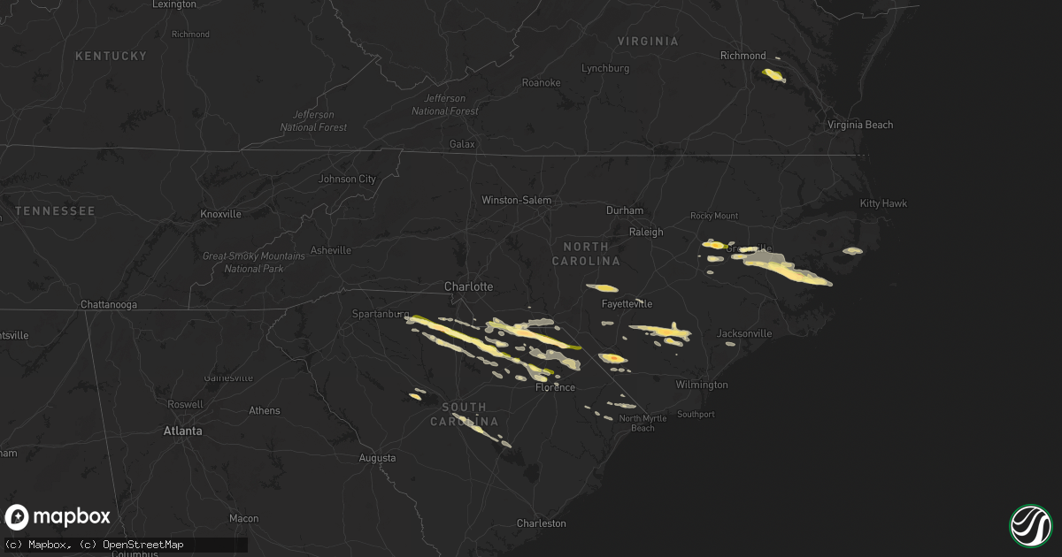
Hail Map in North Carolina on May 10, 2024
Get this storm
May 10 map
$229
one time, instant access
Download today. No call, no setup
Keep the $229
Bought the map and want the full workflow? Apply the entire $229 to a subscription within 7 days. None of it is wasted.
Every map, not just this one
This buys you this map. Subscription and you get every map we run, in the markets you choose from a few cities to whole states to nationwide. Plus real-time alerts the moment a storm fires.
Contact data
Name, contact info, occupancy, even credit band for addresses in the footprint. You go from where it hit to who to call.
Become the source they trust
Unlimited branding weather history reports on demand. You already have the documented answer ready for the property owner, and you are the one who showed up with it.
Property data and RoofTrace estimates
Pull up any address you have got, its value and the exact code rules for that jurisdiction, straight from One Click Code. Then RoofTrace estimates the squares, pitch, and roof value, priced the way you price.
Storm reports in North Carolina
North Carolina
| Date | Description |
|---|---|
| 05/10/20245:59 PM CDT | Duke energy outage caused by fallen trees or limbs damaging equipment. |
| 05/10/20245:04 PM CDT | Several areas of power outages east of aurora caused by falling tree limbs or power pole damage. |
| 05/10/20244:50 PM CDT | A few power poles damaged due to thunderstorm wind gusts. |
| 05/10/20244:50 PM CDT | Downed trees along the 100 block of webster street in downtown whiteville. Time estimated by radar. |
| 05/10/20244:47 PM CDT | Over 1...000 power outages reported near blounts creek. |
| 05/10/20244:44 PM CDT | Delayed report. Beaufort county 911 reported trees and power lines down... And trees blocking roads from blounts creek to aurora. |
| 05/10/20244:35 PM CDT | Columbus county em reports tree down at old lumberton rd and paul wiloughby rd in evergreen. Time estimated via radar. |
| 05/10/20244:21 PM CDT | Downed tree near the intersection of red hill road and green elkins road. Time estimated by radar. |
| 05/10/20244:00 PM CDT | Lots of quarter size hail reported in greenville. Some stones were slightly larger. Report relayed via witn. |
| 05/10/20244:00 PM CDT | Downed trees along old lumberton road just south of the arthur collier road intersection in evergreen. Time estimated by radar. |
| 05/10/20244:00 PM CDT | Delayed report. Trees down in berkley estates southeast of greenville. Report via pitt county. Time estimated via radar. |
| 05/10/20243:59 PM CDT | Report from mping: quarter |
| 05/10/20243:57 PM CDT | Power outages reported by jones-onslow electric membership corporation. |
| 05/10/20243:53 PM CDT | Quarter size hail reported in orrum... Nc |
| 05/10/20243:44 PM CDT | Robeson county em reports golf ball size hail near proctorville |
| 05/10/20243:44 PM CDT | Robeson county em reports trees down at atkinson rd and broadridge rd. Time estimated via radar. |
| 05/10/20243:44 PM CDT | Robeson county e |
| 05/10/20243:41 PM CDT | Still hailing at this time. Estimated wind gust of 30 to 40 mph with initial outflow. |
| 05/10/20243:25 PM CDT | Bladen county em reports tree down at nc 701 and nc 210 |
| 05/10/20243:24 PM CDT | Estimated ping pong size hail reported in saratoga... Nc. Hail damage to car and metal roof of pavilion. |
| 05/10/20243:21 PM CDT | A local report indicates 1.75 inch wind near Garland |
| 05/10/20243:16 PM CDT | Bladen county em reports tree down at nc 701 and nc 210. Time estimated via radar |
| 05/10/20243:09 PM CDT | Tree on a home near the intersection of odell rd. And goodyear dr. |
| 05/10/20243:09 PM CDT | Roof torn off a mobile home on romie st. |
| 05/10/20243:06 PM CDT | Pk wnd 31057/06. |
| 05/10/20242:51 PM CDT | Delayed report. Tree down on heber hudson road. Time estimated based on radar. |
All States Impacted by Hail Map on May 10, 2024
Cities Impacted by Hail Map on May 10, 2024
- Enterprise, MS
- Meridian, MS
- Vossburg, MS
- Paulding, MS
- Pachuta, MS
- Quitman, MS
- Heidelberg, MS
- Rose Hill, MS
- McDavid, FL
- Century, FL
- Bay Minette, AL
- Baker, FL
- Laurel Hill, FL
- Jay, FL
- Crestview, FL
- Milton, FL
- Molino, FL
- Defuniak Springs, FL
- Waynesville, GA
- Waverly, GA
- White Oak, GA
- Gulfport, MS
- Fountain, FL
- Alford, FL
- Cantonment, FL
- Robertsdale, AL
- Perry, FL
- Mayo, FL
- Day, FL
- Jasper, FL
- White Springs, FL
- Jacksonville, FL
- Atlantic Beach, FL
- Pensacola, FL
- Biloxi, MS
- Diberville, MS
- Ocean Springs, MS
- Gulf Breeze, FL
- Hosford, FL
- Carrabelle, FL
- Sopchoppy, FL
- Panacea, FL
- Vancourt, TX
- Waxhaw, NC
- Monroe, NC
- Pacolet, SC
- Gaffney, SC
- Marshville, NC
- Pageland, SC
- Hickory Grove, SC
- Sharon, SC
- Crawfordville, FL
- Jonesville, SC
- Lancaster, SC
- Maryneal, TX
- Mount Croghan, SC
- McConnells, SC
- Chester, SC
- Ruby, SC
- Chesterfield, SC
- Blackwell, TX
- Shannon, NC
- Red Springs, NC
- Wadesboro, NC
- York, SC
- Rock Hill, SC
- Cheraw, SC
- Polkton, NC
- Peachland, NC
- Morven, NC
- Rockingham, NC
- Wingate, TX
- Richburg, SC
- San Saba, TX
- Fredonia, TX
- Catawba, SC
- Saint Pauls, NC
- Lumber Bridge, NC
- Jefferson, SC
- Cherokee, TX
- Fort Lawn, SC
- Wallace, SC
- Farmville, NC
- Snow Hill, NC
- Kershaw, SC
- Bennettsville, SC
- Clio, SC
- Edgemoor, SC
- Heath Springs, SC
- Tar Heel, NC
- White Oak, NC
- Greenville, NC
- Ayden, NC
- Winterville, NC
- Carthage, NC
- Pontotoc, TX
- Valley Spring, TX
- McBee, SC
- Vass, NC
- Fort Bragg, NC
- Southern Pines, NC
- Cameron, NC
- Patrick, SC
- Fayetteville, NC
- Eldorado, TX
- Union, SC
- Black Creek, NC
- Wilson, NC
- Elizabethtown, NC
- Garland, NC
- Spring Lake, NC
- Pope Army Airfield, NC
- Hartsville, SC
- Lampasas, TX
- McColl, SC
- Little Rock, SC
- Bethune, SC
- Harrells, NC
- Society Hill, SC
- Stantonsburg, NC
- Charles City, VA
- Providence Forge, VA
- Walstonburg, NC
- Carlisle, SC
- Washington, NC
- Blackstock, SC
- Rose Hill, NC
- Pikeville, NC
- Fremont, NC
- Stedman, NC
- Spring Grove, VA
- New Kent, VA
- Fairmont, NC
- Orrum, NC
- Blenheim, SC
- Wallace, NC
- Lumberton, NC
- Fountain, NC
- Latta, SC
- Menard, TX
- Willard, NC
- Great Falls, SC
- Darlington, SC
- Goldsboro, NC
- La Grange, NC
- Ivanhoe, NC
- Grimesland, NC
- Camden, SC
- Vanceboro, NC
- Chocowinity, NC
- Lometa, TX
- Bend, TX
- Evergreen, NC
- Maple Hill, NC
- Cassatt, SC
- Westville, SC
- Blounts Creek, NC
- Kelly, NC
- Brady, TX
- Edward, NC
- Engelhard, NC
- Fairfield, NC
- Bishopville, SC
- Columbia, SC
- Aurora, NC
- Hopkins, SC
- Lamar, SC
- Cerro Gordo, NC
- Chadbourn, NC
- Bath, NC
- Hobucken, NC
- Saint Matthews, SC
- Florence, SC
- Lowland, NC
- Gadsden, SC
- Bayboro, NC
- Pinewood, SC
- Loris, SC
- Aynor, SC
- Lilesville, NC
- Gresham, SC
- Marion, SC
- Summerton, SC
- Galivants Ferry, SC
- Eastover, SC
- Cameron, SC
- Hamlet, NC
- Conway, SC
- Little River, SC
- Prosperity, SC
- Leesville, SC
- Chapin, SC
- Little Mountain, SC
- Clinton, NC
- Gilbert, SC
- Rowland, NC
- Lake View, SC
- Moriarty, NM
- Creswell, NC
- Belhaven, NC
- Orlando, FL


