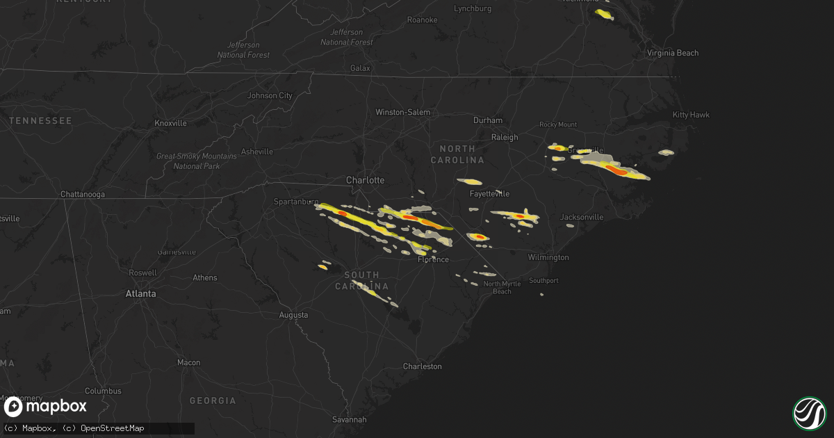
Hail Map on May 10, 2024
Get this storm
May 10 map
$229
one time, instant access
Download today. No call, no setup
Keep the $229
Bought the map and want the full workflow? Apply the entire $229 to a subscription within 7 days. None of it is wasted.
Every map, not just this one
This buys you this map. Subscription and you get every map we run, in the markets you choose from a few cities to whole states to nationwide. Plus real-time alerts the moment a storm fires.
Contact data
Name, contact info, occupancy, even credit band for addresses in the footprint. You go from where it hit to who to call.
Become the source they trust
Unlimited branding weather history reports on demand. You already have the documented answer ready for the property owner, and you are the one who showed up with it.
Property data and RoofTrace estimates
Pull up any address you have got, its value and the exact code rules for that jurisdiction, straight from One Click Code. Then RoofTrace estimates the squares, pitch, and roof value, priced the way you price.
States Impacted by Hail Map on May 10, 2024
Storm reports
Minnesota
| Date | Description |
|---|---|
| 05/10/20245:45 PM CDT | Large red pine tree on house. |
| 05/10/20245:33 PM CDT | Tree down on munger shaw road. |
| 05/10/20245:28 PM CDT | Tree down at gypsy creek farm. |
| 05/10/20245:16 PM CDT | Large tree down with a picture of where it clipped a house damaging the roof and gutters. Also posted a video of frothy lake as the storm passed. From facebook. |
South Carolina
| Date | Description |
|---|---|
| 05/10/20246:15 PM CDT | Public call reported large limb down in backyard in conway |
| 05/10/20246:00 PM CDT | Sc highway patrol reported a tree down in roadway on i95... East of summerton. Time estimated by radar. |
| 05/10/20245:31 PM CDT | Public report with numerous photos of farming irrigation pivots flipped and power poles knocked down in the fields one mile southeast of us 601 and sc 267. Time estimat |
| 05/10/20245:26 PM CDT | Calhoun county em reported quarter size hail at the intersection of adams road and sc 419. Time estimated by radar. |
| 05/10/20245:26 PM CDT | Corrects previous tstm wnd dmg report from 7 ne saint matthews. Calhoun county em reported quarter size hail at the intersection of adams road and sc 419. Time estimate |
| 05/10/20245:10 PM CDT | Sc highway patrol reported trees blocking roadway in eastover at main street and henry street. Time estimated by radar. |
| 05/10/20245:00 PM CDT | Pictures of quarter sized hail reported via social media along timmonsville highway. Time estimated via radar. |
| 05/10/20244:50 PM CDT | Lee county dispatch reported tree down on shirley circle and ashland stokes bridge road. Time estimated by radar. |
| 05/10/20244:40 PM CDT | Public report of quarter size hail at 540pm in cassatt. |
| 05/10/20244:40 PM CDT | Sc highway patrol reported trees down on roadway along arcadia woods road. Time esti |
| 05/10/20244:40 PM CDT | Public report of |
| 05/10/20244:40 PM CDT | Sc highway patrol reported trees down on roadway along arcadia woods road. Time estimated by radar. |
| 05/10/20244:30 PM CDT | Spotter reported trees down at cherokee trail and old cherokee road. Time estimated by radar. |
| 05/10/20244:30 PM CDT | Powerlines down along weed drive. Time estimated by radar. |
| 05/10/20244:12 PM CDT | Picture of hail stones larger than a quarter in mechanicsville submitted via social media. Time estimated via radar. |
| 05/10/20244:05 PM CDT | Public report of greater than quarter sized hail along prosperity highway. Time estimated by radar. |
| 05/10/20243:45 PM CDT | Estimated half dollar size hail reported in hartsville. Time estimated from radar. |
| 05/10/20243:30 PM CDT | Public report of dime sized and quarter sized hail at highway 151 and 5th street in mcbee. |
| 05/10/20242:55 PM CDT | Public report and video of quarter sized at the gold mine in kershaw. |
| 05/10/20242:51 PM CDT | Public report of quarter sized hail with photos on the north side of kershaw. |
| 05/10/20242:47 PM CDT | Public report with video of ping pong ball sized hail at andrew jackson high school northwest of kershaw. Time estimated by radar. |
| 05/10/20242:47 PM CDT | Corrects previous tstm wnd dmg report from 3 nw kershaw. Public report with video of ping pong ball sized hail at andrew jackson high school northwest of kershaw. Time |
| 05/10/20242:36 PM CDT | Quarter-sized hail fell in bennettsville. Photo evidence tweeted by broadcast media. Event time estimated by radar. |
| 05/10/20242:32 PM CDT | Public report of dime and quarter sized hail near lancaster golf course. Time estimated. |
| 05/10/20242:32 PM CDT | Public report with photos of quarter sized hail just south of lancaster. Time estimated. |
| 05/10/20242:20 PM CDT | Ibhs meteorologist reported up to 1.3 inch diameter hail in fort lawn. |
| 05/10/20242:15 PM CDT | Skywarn spotters noted several reports of quarter sized hail just north of cheraw along highway 52 at 315pm. |
| 05/10/20242:12 PM CDT | Broadcast meteorologist passed on a public report with photo of roughly ping-pong sized hail in cheraw. |
| 05/10/20242:07 PM CDT | Report from mping: quarter |
| 05/10/20242:05 PM CDT | Picture of 1.0-1.25 inch hail in the town of richburg. |
| 05/10/20242:00 PM CDT | A local report indicates 1.00 inch wind near Lowrys |
| 05/10/20241:55 PM CDT | Chesterfield county emergency manager reported quarter sized hail in chesterfield city limits. Time estimated. |
| 05/10/20241:55 PM CDT | Golf ball hail. |
| 05/10/20241:55 PM CDT | Broadcast meteorologist reported ping-pong to golf ball sized hail in ruby at 255pm. |
| 05/10/20241:55 PM CDT | Chesterfield county emergency manager reported a tree down on house in chesterfield city limits. Time estimated. |
| 05/10/20241:16 PM CDT | Quarter sized hail reported at 2:16p near the wolf pond rd and sc 207 by buford sc fire. |
| 05/09/20247:57 PM CDT | Broadcast media relayed a public report of a tree blown down on a home on minnie st in west ashley... Causing considerable damage. |
| 05/09/20247:35 PM CDT | Tree down on forks rd. |
| 05/09/20247:14 PM CDT | Tree down on clatty farm rd. |
| 05/09/20247:14 PM CDT | Tree down on clatty farm rd |
| 05/09/20247:13 PM CDT | Tree down on beavers pass rd at sunrise rd. |
Virginia
| Date | Description |
|---|---|
| 05/10/20243:30 PM CDT | A local report indicates 1.25 inch wind near New Hope |
| 05/10/20243:29 PM CDT | Quarter size hail covering the ground. |
Wisconsin
| Date | Description |
|---|---|
| 05/10/20246:05 PM CDT | Pea size hail and heavy wind around 605 pm blew over a 40 pound deck chair with a steel base and branches around 1.5 inches in diameter came off a few trees. |
Florida
| Date | Description |
|---|---|
| 05/10/202410:53 AM CDT | Golf ball sized hail falling in alligator point on alligator dr. |
| 05/10/20249:30 AM CDT | Reports of 11 schools without power in duval county. Trees down county wide... With some having fallen on homes. |
| 05/10/20249:25 AM CDT | As of 10:25am... ~200f customers without power in columbia county...fl. |
| 05/10/20249:00 AM CDT | Reports of 18000/24000 |
| 05/10/20248:53 AM CDT | Asos station kcrg jacksonvil craig. |
| 05/10/20248:52 AM CDT | Awos station knrb mayport naval station. |
| 05/10/20248:52 AM CDT | Photos of tree damage and power lines down along neptune lane in neptune beach. Time based off gust reading from knrb. |
| 05/10/20248:44 AM CDT | Mesonet station xjak jacksonville. |
| 05/10/20248:40 AM CDT | Mesonet station 1323w 1.3 se jacksonville |
| 05/10/20248:40 AM CDT | Mesonet station 1483w fswn jfrd station 40. |
| 05/10/20248:31 AM CDT | Trees snapped from severe winds at bryceville... Fl homes. Time based off nearest mesonet station gust reading of 47mph. |
| 05/10/20248:30 AM CDT | Mesonet station blif1 1 wnw fort caroline. |
| 05/10/20248:24 AM CDT | Awos station knip jacksonville nas. |
| 05/10/20248:20 AM CDT | Video of roof damage to business. Time based off kjax wind gust reading of 64 mph. |
| 05/10/20248:20 AM CDT | Asos station kjax jacksonville intl airport. |
| 05/10/20248:05 AM CDT | Report from mping: trees uprooted or snapped; roof blown off. |
| 05/10/20247:55 AM CDT | Reports of trees down on property. No structural damage. Time est off radar. |
| 05/10/20247:50 AM CDT | Report from mping: 1-inch tree limbs broken; shingles blown off. Time estimated by radar. |
| 05/10/20247:48 AM CDT | Numerous trees down to the northeast of sanderson. Some older buildings sustained some damage. Power still out in some locations. Time est based on radar. |
| 05/10/20247:38 AM CDT | Several trees down across chiefland and fanning springs. One of those trees fell on a powerline. |
| 05/10/20247:38 AM CDT | Several trees down across chiefland and fanning springs. One of those trees feel on a powerline. |
| 05/10/20247:35 AM CDT | Awos station klcq lake city. |
| 05/10/20247:30 AM CDT | Mesonet station 1175w 5.1 sw belmont |
| 05/10/20247:25 AM CDT | Old oak trees snapped... Twisted trees... Lawn furniture blown around... Power outage. Images provided through social media. |
| 05/10/20247:10 AM CDT | Davis weather station gusted to 60 mph. |
| 05/10/20247:10 AM CDT | Several trees down across lafayette county. |
| 05/10/20247:03 AM CDT | Tree down on power lines on county road 141 madison county side. |
| 05/10/20241:17 AM CDT | The asos at the orlando executive airport measured a wind gust of 56mph/49kts from the west-northwest. |
| 05/10/20241:05 AM CDT | [delayed report] trees reported down on corsino st in the tuscany neighborhood. |
Texas
| Date | Description |
|---|---|
| 05/10/20244:35 PM CDT | A local report indicates 1.50 inch wind near Menard |
| 05/10/20244:35 PM CDT | A local report indicates 1.00 inch wind near Menard |
| 05/10/20242:35 PM CDT | Marble to ping pong size hail in cherokee. |
| 05/10/20241:35 PM CDT | Tree damage... Including a chinese elm laying on the roof of a building. |
North Carolina
| Date | Description |
|---|---|
| 05/10/20245:59 PM CDT | Duke energy outage caused by fallen trees or limbs damaging equipment. |
| 05/10/20245:04 PM CDT | Several areas of power outages east of aurora caused by falling tree limbs or power pole damage. |
| 05/10/20244:50 PM CDT | Downed trees along the 100 block of webster street in downtown whiteville. Time estimated by radar. |
| 05/10/20244:50 PM CDT | A few power poles damaged due to thunderstorm wind gusts. |
| 05/10/20244:47 PM CDT | Over 1...000 power outages reported near blounts creek. |
| 05/10/20244:44 PM CDT | Delayed report. Beaufort county 911 reported trees and power lines down... And trees blocking roads from blounts creek to aurora. |
| 05/10/20244:35 PM CDT | Columbus county em reports tree down at old lumberton rd and paul wiloughby rd in evergreen. Time estimated via radar. |
| 05/10/20244:21 PM CDT | Downed tree near the intersection of red hill road and green elkins road. Time estimated by radar. |
| 05/10/20244:00 PM CDT | Downed trees along old lumberton road just south of the arthur collier road intersection in evergreen. Time estimated by radar. |
| 05/10/20244:00 PM CDT | Lots of quarter size hail reported in greenville. Some stones were slightly larger. Report relayed via witn. |
| 05/10/20244:00 PM CDT | Delayed report. Trees down in berkley estates southeast of greenville. Report via pitt county. Time estimated via radar. |
| 05/10/20243:59 PM CDT | Report from mping: quarter |
| 05/10/20243:57 PM CDT | Power outages reported by jones-onslow electric membership corporation. |
| 05/10/20243:53 PM CDT | Quarter size hail reported in orrum... Nc |
| 05/10/20243:44 PM CDT | Robeson county em reports golf ball size hail near proctorville |
| 05/10/20243:44 PM CDT | Robeson county e |
| 05/10/20243:44 PM CDT | Robeson county em reports trees down at atkinson rd and broadridge rd. Time estimated via radar. |
| 05/10/20243:41 PM CDT | Still hailing at this time. Estimated wind gust of 30 to 40 mph with initial outflow. |
| 05/10/20243:25 PM CDT | Bladen county em reports tree down at nc 701 and nc 210 |
| 05/10/20243:24 PM CDT | Estimated ping pong size hail reported in saratoga... Nc. Hail damage to car and metal roof of pavilion. |
| 05/10/20243:21 PM CDT | A local report indicates 1.75 inch wind near Garland |
| 05/10/20243:16 PM CDT | Bladen county em reports tree down at nc 701 and nc 210. Time estimated via radar |
| 05/10/20243:09 PM CDT | Roof torn off a mobile home on romie st. |
| 05/10/20243:09 PM CDT | Tree on a home near the intersection of odell rd. And goodyear dr. |
| 05/10/20243:06 PM CDT | Pk wnd 31057/06. |
| 05/10/20242:51 PM CDT | Delayed report. Tree down on heber hudson road. Time estimated based on radar. |
Georgia
| Date | Description |
|---|---|
| 05/10/20248:10 AM CDT | Trees uprooted... Power outages... Minor structural damage reported. Time est off radar. |
| 05/10/20248:05 AM CDT | Gusts knocked down trees and power lines across charlton county... Ga... Leading to power outages. Time est based off radar. |
| 05/10/20247:00 AM CDT | Tree down along new statenville highway. |
| 05/10/20247:00 AM CDT | Tree down on boring pond road. |
Cities Impacted by Hail Map on May 10, 2024
- Enterprise, MS
- Meridian, MS
- Vossburg, MS
- Paulding, MS
- Pachuta, MS
- Quitman, MS
- Heidelberg, MS
- Rose Hill, MS
- McDavid, FL
- Century, FL
- Bay Minette, AL
- Baker, FL
- Laurel Hill, FL
- Jay, FL
- Crestview, FL
- Milton, FL
- Molino, FL
- Defuniak Springs, FL
- Waynesville, GA
- Waverly, GA
- White Oak, GA
- Gulfport, MS
- Fountain, FL
- Alford, FL
- Cantonment, FL
- Robertsdale, AL
- Perry, FL
- Mayo, FL
- Day, FL
- Jasper, FL
- White Springs, FL
- Jacksonville, FL
- Atlantic Beach, FL
- Pensacola, FL
- Biloxi, MS
- Diberville, MS
- Ocean Springs, MS
- Gulf Breeze, FL
- Hosford, FL
- Carrabelle, FL
- Sopchoppy, FL
- Panacea, FL
- Vancourt, TX
- Waxhaw, NC
- Monroe, NC
- Pacolet, SC
- Gaffney, SC
- Marshville, NC
- Pageland, SC
- Hickory Grove, SC
- Sharon, SC
- Crawfordville, FL
- Jonesville, SC
- Lancaster, SC
- Maryneal, TX
- Mount Croghan, SC
- McConnells, SC
- Chester, SC
- Ruby, SC
- Chesterfield, SC
- Blackwell, TX
- Shannon, NC
- Red Springs, NC
- Wadesboro, NC
- York, SC
- Rock Hill, SC
- Cheraw, SC
- Polkton, NC
- Peachland, NC
- Morven, NC
- Rockingham, NC
- Wingate, TX
- Richburg, SC
- San Saba, TX
- Fredonia, TX
- Catawba, SC
- Saint Pauls, NC
- Lumber Bridge, NC
- Jefferson, SC
- Cherokee, TX
- Fort Lawn, SC
- Wallace, SC
- Farmville, NC
- Snow Hill, NC
- Kershaw, SC
- Bennettsville, SC
- Clio, SC
- Edgemoor, SC
- Heath Springs, SC
- Tar Heel, NC
- White Oak, NC
- Greenville, NC
- Ayden, NC
- Winterville, NC
- Carthage, NC
- Pontotoc, TX
- Valley Spring, TX
- McBee, SC
- Vass, NC
- Fort Bragg, NC
- Southern Pines, NC
- Cameron, NC
- Patrick, SC
- Fayetteville, NC
- Eldorado, TX
- Union, SC
- Black Creek, NC
- Wilson, NC
- Elizabethtown, NC
- Garland, NC
- Spring Lake, NC
- Pope Army Airfield, NC
- Hartsville, SC
- Lampasas, TX
- McColl, SC
- Little Rock, SC
- Bethune, SC
- Harrells, NC
- Society Hill, SC
- Stantonsburg, NC
- Charles City, VA
- Providence Forge, VA
- Walstonburg, NC
- Carlisle, SC
- Washington, NC
- Blackstock, SC
- Rose Hill, NC
- Pikeville, NC
- Fremont, NC
- Stedman, NC
- Spring Grove, VA
- New Kent, VA
- Fairmont, NC
- Orrum, NC
- Blenheim, SC
- Wallace, NC
- Lumberton, NC
- Fountain, NC
- Latta, SC
- Menard, TX
- Willard, NC
- Great Falls, SC
- Darlington, SC
- Goldsboro, NC
- La Grange, NC
- Ivanhoe, NC
- Grimesland, NC
- Camden, SC
- Vanceboro, NC
- Chocowinity, NC
- Lometa, TX
- Bend, TX
- Evergreen, NC
- Maple Hill, NC
- Cassatt, SC
- Westville, SC
- Blounts Creek, NC
- Kelly, NC
- Brady, TX
- Edward, NC
- Engelhard, NC
- Fairfield, NC
- Bishopville, SC
- Columbia, SC
- Aurora, NC
- Hopkins, SC
- Lamar, SC
- Cerro Gordo, NC
- Chadbourn, NC
- Bath, NC
- Hobucken, NC
- Saint Matthews, SC
- Florence, SC
- Lowland, NC
- Gadsden, SC
- Bayboro, NC
- Pinewood, SC
- Loris, SC
- Aynor, SC
- Lilesville, NC
- Gresham, SC
- Marion, SC
- Summerton, SC
- Galivants Ferry, SC
- Eastover, SC
- Cameron, SC
- Hamlet, NC
- Conway, SC
- Little River, SC
- Prosperity, SC
- Leesville, SC
- Chapin, SC
- Little Mountain, SC
- Clinton, NC
- Gilbert, SC
- Rowland, NC
- Lake View, SC
- Moriarty, NM
- Creswell, NC
- Belhaven, NC
- Orlando, FL