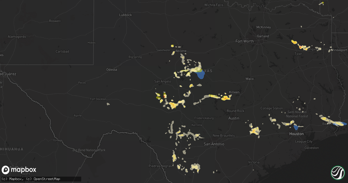
Hail Map in Texas on May 8, 2023
Get this storm
May 8 map
$229
one time, instant access
Download today. No call, no setup
Keep the $229
Bought the map and want the full workflow? Apply the entire $229 to a subscription within 7 days. None of it is wasted.
Every map, not just this one
This buys you this map. Subscription and you get every map we run, in the markets you choose from a few cities to whole states to nationwide. Plus real-time alerts the moment a storm fires.
Contact data
Name, contact info, occupancy, even credit band for addresses in the footprint. You go from where it hit to who to call.
Become the source they trust
Unlimited branding weather history reports on demand. You already have the documented answer ready for the property owner, and you are the one who showed up with it.
Property data and RoofTrace estimates
Pull up any address you have got, its value and the exact code rules for that jurisdiction, straight from One Click Code. Then RoofTrace estimates the squares, pitch, and roof value, priced the way you price.
Storm reports in Texas
Texas
| Date | Description |
|---|---|
| 05/08/20236:40 PM CDT | Wind gust occurred at the kiah asos site. |
| 05/08/20236:23 PM CDT | *** 1 fatal *** law enforcement reported that a tree fell on a vehicle near the intersection of east cypresswood dr and whitewood dr. One fatality reported. |
| 05/08/20235:56 PM CDT | Public and media reports of hail between quarter and half dollar size. |
| 05/08/20235:35 PM CDT | Quarter size hail currently falling. |
| 05/08/20235:00 PM CDT | Hail size estimated via public photo on social media. |
| 05/08/20234:37 PM CDT | Large portion of orange texas without power after storm has passed. |
| 05/08/20234:36 PM CDT | Part of a tin roof was blown across 9th street in orange... Tx. Taking down a power line. |
| 05/08/20234:36 PM CDT | Large branch broken off a tree. |
| 05/08/20234:36 PM CDT | Large tree fell on house... Damaging a roof. |
| 05/08/20234:34 PM CDT | A trampoline was blown trough a fence off of snake road. |
| 05/08/20234:30 PM CDT | Tin roof blown off of a hair salon. |
| 05/08/20234:19 PM CDT | Mesonet reports thunderstorm wind gust of 59 mph. |
| 05/08/20233:43 PM CDT | Nickel to quarter size hail in la grange. |
| 05/08/20233:42 PM CDT | Softwood tree split in half. |
| 05/08/20233:25 PM CDT | Numerous power outages reported in and around lumberton. Time estimated by radar. |
| 05/08/20233:15 PM CDT | Media reports 1 inch hail west of lumberton. |
| 05/08/20233:10 PM CDT | Hardin 911 reports possible tornado touched down on fm 421 between sour lake and lumberton. Numerous trees were downed onto the roadway and power lines. Time estimated |
| 05/08/20232:00 AM CDT | Mesonet station xspp spiw park. |
| 05/08/20231:54 AM CDT | Buoy station ptit2 port isabel... Tx. |
| 05/08/20231:54 AM CDT | Corrects previous marine tstm wind report from 1 sse port isabel. The noaa national ocean service station at port isabel recorded a wind gust of 52 knots... Or 60 mph.. |
| 05/08/20231:45 AM CDT | Member of the public from isla blanca reported power being out... Two trailers flipped onto their ceilings... Awnings ripped off... Trailer jacks bent... Road signs ben |
| 05/08/20231:41 AM CDT | The port isabel police department shared pictures on social media showing damage to the sunoco gas station awning at the corner of hwy48 and hwy100 and an ice chest tha |
| 05/08/20231:41 AM CDT | Port isabel police department reported several powerlines down around town. Timing based on radar. |
| 05/08/20231:25 AM CDT | Metal carport blown over and across street. Time estimated from radar. |
| 05/08/20231:19 AM CDT | Asos station kbro brownsville. |
| 05/08/20231:19 AM CDT | The asos station at brownsville-south padre international airport gusted to 64 mph at 1:19am cdt. |
| 05/08/20231:15 AM CDT | 18 inch diameter tree trunk split in half. Estimated wind speed 60 mph. |
| 05/07/20239:31 PM CDT | Report from mping quarter. |
| 05/07/20239:30 PM CDT | Trained spotters reported winds of 60 to 65 mph in the city of bangs. |
| 05/07/20238:23 PM CDT | A local report indicates 1.00 inch wind near COLEMAN |
| 05/07/20238:20 PM CDT | Golfball size hail fell near the hainesville community. |
| 05/07/20238:19 PM CDT | A local report indicates 1.00 inch wind near BALLINGER |
| 05/07/20238:06 PM CDT | Hail currently falling... Most is pea size... |
| 05/07/20238:06 PM CDT | Hail currently falling... Most is pea size... But the biggest is a little bigger than quarter size. |
| 05/07/20237:35 PM CDT | Mostly quarter size hail with some much larger hailstones in excess of golfballs are covering the ground in hawkins. |
| 05/07/20237:21 PM CDT | A lot of small hail... But biggest hail was up to golf ball size. |
| 05/07/20237:15 PM CDT | A picture was posted to social media of golf ball size hail that fell in the friendship community southwest of gladewater. |
All States Impacted by Hail Map on May 8, 2023
Cities Impacted by Hail Map on May 8, 2023
- Morocco, IN
- Brook, IN
- Carmi, IL
- Kountze, TX
- Lumberton, TX
- La Grange, TX
- Rolla, MO
- Newburg, MO
- Saint James, MO
- Salem, MO
- Cook Sta, MO
- Orange, TX
- Bridge City, TX
- Vidor, TX
- Cameron, LA
- Vinton, LA
- Butler, MO
- Amoret, MO
- Foster, MO
- Sulphur, LA
- Deepwater, MO
- Lowry City, MO
- Boss, MO
- Hackberry, LA
- Merkel, TX
- Springfield, MN
- Gravois Mills, MO
- Climax Springs, MO
- Edwards, MO
- Sleepy Eye, MN
- Comfrey, MN
- Muldoon, TX
- Schulenburg, TX
- Bunker, MO
- Tomball, TX
- Spring, TX
- Rich Hill, MO
- Rockville, MO
- Camdenton, MO
- Sunrise Beach, MO
- Roach, MO
- Winona, TX
- Waller, TX
- Hempstead, TX
- Marshall, TX
- Benton, LA
- Bossier City, LA
- Gladewater, TX
- Saratoga, TX
- Smithville, TX
- Clarkston, WA
- Lewiston, ID
- Wilmar, AR
- Plain Dealing, LA
- Livingston, TX
- Corrigan, TX
- Chester, TX
- Waskom, TX
- West Point, TX
- Longview, TX
- Garrison, TX
- Mount Enterprise, TX
- Jefferson, TX
- Malta, MT
- Camden, AR
- Huntsville, TX
- New Waverly, TX
- Waldo, AR
- McHenry, MS
- Giddings, TX
- Fayetteville, TX
- Ellinger, TX
- Chappell Hill, TX
- Washington, TX
- Brenham, TX
- Warren, AR
- Hallsville, TX
- Beaumont, TX
- Buckner, AR
- Thornton, AR
- Shepherd, TX
- Cleveland, TX
- Somerville, TX
- Weimar, TX
- Montgomery, TX
- Mooringsport, LA
- Shreveport, LA
- Big Sandy, TX
- Flatonia, TX
- Chidester, AR
- De Berry, TX
- Stephens, AR
- Brookshire, TX
- Coldspring, TX
- McNeil, AR
- Round Top, TX
- Burton, TX
- Navasota, TX
- Anderson, TX
- Karnack, TX
- Buna, TX
- Silsbee, TX
- Greenwood, LA
- Texarkana, AR
- Black, MO
- Crocker, MO
- Richland, MO
- Elk Point, SD
- Beldenville, WI
- Ellsworth, WI
- Spring Valley, WI
- Elmwood, WI
- Maiden Rock, WI
- Centerville, MO
- Montreal, MO
- Linn Creek, MO
- Stoutland, MO
- Hume, MO
- Fort Scott, KS
- Prescott, KS
- Schell City, MO
- Walker, MO
- Waynesville, MO
- Lesterville, MO
- Stockholm, WI
- Humble, TX
- Houston, TX
- Amboy, MN
- Mapleton, MN
- Good Thunder, MN
- Steelville, MO
- Terril, IA
- Milford, IA
- Briggs, TX
- Lampasas, TX
- Ruthven, IA
- Kempner, TX
- Graettinger, IA
- Emmetsburg, IA
- Estherville, IA
- London, TX
- Laquey, MO
- Menard, TX
- Armstrong, IA
- Richards, MO
- Deerfield, MO
- Junction, TX
- Nevada, MO
- Fenton, IA
- Bancroft, IA
- Swea City, IA
- Lone Rock, IA
- Jackson, MN
- Christoval, TX
- Spirit Lake, IA
- Eldorado, TX
- Alpha, MN
- Dunnell, MN
- Dolliver, IA
- Coleman, TX
- Santa Anna, TX
- Dixon, MO
- Devils Elbow, MO
- Elysian, MN
- Duke, MO
- Waterville, MN
- Edgar Springs, MO
- Janesville, MN
- Waseca, MN
- Bertram, TX
- Bourbon, MO
- Cylinder, IA
- West Bend, IA
- Whittemore, IA
- Smithland, IA
- Rodney, IA
- Mapleton, IA
- Oto, IA
- Hawkins, TX
- Tyler, TX
- Lindale, TX
- Annapolis, MO
- Ute, IA
- Charter Oak, IA
- Denison, IA
- Faribault, MN
- Nerstrand, MN
- Burnet, TX
- Des Arc, MO
- Milo, MO
- Dixon, KY
- Manitou, KY
- Slaughters, KY
- Sebree, KY
- El Dorado, AR
- De Queen, AR
- Horatio, AR
- Ballinger, TX
- Dow City, IA
- Arion, IA
- Ottosen, IA
- Mineola, TX
- Quitman, TX
- Hanson, KY
- Rowena, TX
- Ellington, MO
- Redford, MO
- Silva, MO
- Fredericktown, MO
- Greenville, MO
- Sheldon, MO
- Talpa, TX
- Moundville, MO
- Bangs, TX
- Brownwood, TX
- Madisonville, KY
- Earlington, KY
- Alba, TX
- San Saba, TX
- Piedmont, MO
- Vulcan, MO
- Cherokee, TX
- Early, TX
- May, TX
- Kirkman, IA
- Defiance, IA
- Irwin, IA
- Harlan, IA
- Brookesmith, TX
- Zephyr, TX
- Blanket, TX
- Glenallen, MO
- Patterson, MO
- Farlington, KS
- Arcadia, KS
- Marble Hill, MO
- Zalma, MO
- Mulberry, KS
- Willow Springs, MO
- Vanzant, MO
- Advance, MO
- Sturdivant, MO
- Brownwood, MO
- Bloomfield, MO
- Oran, MO
- Bell City, MO
- Essex, MO
- Sikeston, MO
- Vanduser, MO
- Bertrand, MO
- Benton, MO
- Charleston, MO
- Chaffee, MO
- Cape Girardeau, MO
- Whitewater, MO
- Scott City, MO
- Thebes, IL
- Tamms, IL
- Olive Branch, IL
- Miller City, IL
- Cherryville, MO
- Cairo, IL
- Villa Ridge, IL
- Mounds, IL
- Pulaski, IL
- Seligman, MO
- Pineville, MO
- Wickliffe, KY
- Mound City, IL
- Barlow, KY
- Olmsted, IL
- La Center, KY
- Kevil, KY
- Trinity, TX
- Saint Joseph, LA
- Waterproof, LA
- Eureka Springs, AR
- Killeen, TX
- Iberia, MO
- Mount Vernon, TX
- Sonora, TX
- Leasburg, MO
- Cuba, MO
- Cypress, TX
- Appleton City, MO
- Bixby, MO
- Hawley, TX
- Abilene, TX
- Bonne Terre, MO
- Kaiser, MO
- Ulman, MO
- Osage Beach, MO
- Lake Ozark, MO
- Brumley, MO
- Prairie Du Rocher, IL
- Castana, IA
- Manilla, IA
- Northfield, MN
- Kenyon, MN
- Morganfield, KY
- Nebo, KY
- Eden, TX
- Crosby, TX
- Huffman, TX
- San Angelo, TX
- Clyde, TX
- Gouldbusk, TX
- Goodhue, MN
- Red Wing, MN
- Welch, MN
- Florence, TX
- Goldsboro, TX
- Greenwell Springs, LA
- Richwoods, MO
- McGee, MO
- Cross Plains, TX
- Hanska, MN
- Saint James, MN
- Madelia, MN
- Valera, TX
- Waverly, KY
- Uniontown, KY
- White Oak, TX
- Worthington, MN
- Sullivan, MO
- Rolfe, IA
- Bradgate, IA
- Rutland, IA
- Mallard, IA
- Sanborn, MN
- Bay City, WI
- Greenville, KY
- Magnolia, AR
- Emerson, AR
- Hillsboro, MO
- De Soto, MO
- Ceylon, MN
- Lu Verne, IA
- Wesley, IA
- Algona, IA
- Fairmont, MN
- Burt, IA
- Sherburn, MN
- Ovalo, TX
- Burbank, SD
- Hockley, TX
- Hager City, WI
- Potosi, MO
- Clubb, MO
- Fort Stockton, TX
- Garden City, MN
- Vernon Center, MN
- Bastrop, TX
- Lewisburg, KY
- Burkett, TX
- Brady, TX
- Melvin, TX
- Festus, MO
- Fults, IL
- Valmeyer, IL
- Fort McKavett, TX
- Novice, TX
- Tuscola, TX
- Lawn, TX
- Clinton, LA
- Madison Lake, MN
- Anthon, IA
- Climbing Hill, IA
- Hornick, IA
- Pea Ridge, AR
- Bella Vista, AR
- Cross Timbers, MO
- Bloomsdale, MO
- Taylor, AR
- Rising Star, TX
- Peace Valley, MO
- West Plains, MO
- Licking, MO
- Baldwin, WI
- Sainte Genevieve, MO
- Puxico, MO
- Saint Robert, MO
- Vichy, MO
- Voss, TX
- Williamsville, MO
- Bucyrus, MO
- Jackson, NE
- Hubbard, NE
- Fordsville, KY
- Mount Holly, AR
- Elkton, KY
- Wappapello, MO
- White Plains, KY
- Graham, KY
- Arma, KS
- Cabool, MO
- Bronaugh, MO
- Winthrop, AR
- Haworth, OK
- Lake Crystal, MN
- Delavan, MN
- Corydon, KY
- Lillie, LA
- Junction City, AR
- Washburn, MO
- Eagle Lake, MN
- Conroe, TX
- Magnolia, TX
- Gilmer, TX
- Hampton, AR
- Fulton, KS
- Ponca, NE
- Corwith, IA
- Blackwell, TX
- Brinktown, MO
- Harwood, MO
- Osceola, MO
- Lowndes, MO
- Gipsy, MO
- Houston, MO
- Solo, MO
- Paige, TX
- Lakefield, MN
- Fort Leonard Wood, MO
- Dierks, AR
- Newhope, AR
- Valles Mines, MO
- Lodi, MO
- Jerome, MO
- Stover, MO
- New Richmond, WI
- Roberts, WI
- Uniontown, KS
- Pleasanton, KS
- Corydon, IN
- Elizabeth, IN
- New Middletown, IN
- Lanesville, IN
- Louisville, KY
- Laconia, IN
- New Albany, IN
- Fairdale, KY
- Fisherville, KY
- Simpsonville, KY
- Finchville, KY
- Georgetown, IN
- Russellville, KY
- Callender, IA
- Moorland, IA
- Fort Dodge, IA
- Story City, IA
- Boone, IA
- Stanhope, IA
- Rumsey, KY
- Calhoun, KY
- Zumbrota, MN
- Harrisburg, AR
- Jonesboro, AR
- Walsh, IL
- Ellis Grove, IL
- Chester, IL
- Pinckneyville, IL
- Coulterville, IL
- Medford, MN
- Stanford, KY
- Danville, KY
- Olaton, KY
- Bluejacket, OK
- Munford, TN
- Brighton, TN
- Atoka, TN
- Westmoreland, TN
- Adolphus, KY
- Rocksprings, TX
- Dilley, TX
- Sharon Grove, KY
- Bandera, TX
- Sonora, KY
- Cotulla, TX
- Humboldt, IA
- Bay, AR
- Weiner, AR
- Edinburg, TX
- Crofton, KY
- Hopkinsville, KY
- New Salisbury, IN
- Crandall, IN
- Ramsey, IN
- Sturgeon Lake, MN
- Kettle River, MN
- Cecilia, KY
- Eastview, KY
- Central, IN
- Leavenworth, IN
- Mauckport, IN
- Cannelton, IN
- Battletown, KY
- Rochelle, TX
- Richland Springs, TX
- Evansville, IL
- Red Bud, IL
- East Bernstadt, KY
- London, KY
- Shell Knob, MO
- Mertzon, TX
- Adairville, KY
- Springfield, TN
- Bono, AR
- Turrell, AR
- Gilmore, AR
- Leachville, AR
- Manila, AR
- Monette, AR
- Utopia, TX
- Paducah, KY
- West Paducah, KY
- Percy, IL
- Sparta, IL
- Cutler, IL
- Steeleville, IL
- Art, TX
- Pontotoc, TX
- Greenbrier, TN
- Brodhead, KY
- Mount Vernon, KY
- Irvine, KY
- Sabinal, TX
- Princeton, KY
- Garland, KS
- Uvalde, TX
- Rio Frio, TX
- Leakey, TX
- Vanderpool, TX
- Medina, TX
- Tarpley, TX
- Concan, TX
- Olmstead, KY
- Eddyville, KY
- Walnut, KS
- Payneville, KY
- Brandenburg, KY
- Eubank, KY
- Waynesburg, KY
- Franklin, KY
- Girard, KS
- Bremen, KY
- Pearsall, TX
- Johnstown, OH
- Central City, KY
- McKee, KY
- Huntsville, AR
- Crystal City, TX
- La Pryor, TX
- Friendship, TN
- Covington, TN
- Drummonds, TN
- Byrdstown, TN
- D Hanis, TX
- Halls, TN
- Valley Spring, TX
- Falls Of Rough, KY
- Dundee, KY
- Hartford, KY
- Stanchfield, MN
- Cambridge, MN
- Junction City, KY
- Parksville, KY
- Mindenmines, MO
- Couch, MO
- Cedar Hill, TN
- Mico, TX
- Crab Orchard, KY
- Cadiz, KY
- Cerulean, KY
- Brownsville, TN
- Carrier Mills, IL
- Lepanto, AR
- Trumann, AR
- Tyronza, AR
- Marked Tree, AR
- Baldwin, IL
- West Point, KY
- Shepherdsville, KY
- Camp Wood, TX
- Cedar Grove, TN
- Whitesville, KY
- Reynolds Station, KY
- Philpot, KY
- Hawesville, KY
- Trenton, TN
- Newbern, TN
- Milan, TN
- Humboldt, TN
- Lavinia, TN
- Finley, TN
- Lohn, TX
- Millington, TN
- Adams, TN
- Cloverport, KY
- Alton, MO
- Duncombe, IA
- Somerset, KY
- Mason, TX
- Dyersburg, TN
- Kuttawa, KY
- Hondo, TX
- Hunt, TX
- Webster City, IA
- Livingston, KY
- Utica, KY
- Pembroke, KY
- Sacramento, KY
- Trenton, KY
- Drakesboro, KY
- Powderly, KY
- Beech Creek, KY
- Auburn, KY
- Cottontown, TN
- White House, TN
- Cross Plains, TN
- Stonefort, IL
- Berea, KY
- Clay, KY
- Pocahontas, IA
- Havelock, IA
- Laurens, IA
- Sandgap, KY
- Hudson, KY
- Garfield, KY
- Big Clifty, KY
- Barksdale, TX
- Mozelle, KY
- Essie, KY
- Stinnett, KY
- Henderson, KY
- Hepler, KS
- Pipe Creek, TX
- Joiner, AR
- Dyess, AR
- Lake City, AR
- Golden, MO
- Rockwood, TX
- Robards, KY
- Owensboro, KY
- State University, AR
- Centertown, KY
- Beaver Dam, KY
- Rockport, KY
- Vinita, OK
- Black Oak, AR
- Knoxville, TN
- Dyer, TN
- Saint Francis, KS
- Bird City, KS
- Benkelman, NE
- Scott City, KS
- McDonald, KS
- Max, NE
- Colby, KS
- Oakley, KS
- Arlington, TN
- Arjay, KY
- Lost Creek, KY
- Clayhole, KY
- Emporia, KS
- Strong City, KS
- White Pine, TN
- Newport, TN
- Stark, KS
- Carrizo Springs, TX
- Abilene, KS
- Booneville, KY
- Beattyville, KY
- Owingsville, KY
- Sharpsburg, KY
- Cottonwood Falls, KS
- Elmdale, KS
- Goodlettsville, TN
- Hendersonville, TN
- Moorefield, KY
- Carlisle, KY
- Welda, KS
- Blue Mound, KS
- Calliham, TX
- Tilden, TX
- Jefferson City, TN
- Dandridge, TN
- Erie, KS
- Sunbright, TN
- Big Wells, TX
- Tazewell, TN
- Linden, TN
- English, IN
- Jamestown, TN
- Burlington, KS
- Waverly, KS
- Burnsville, MS
- Columbia, TN
- Culleoka, TN
- West Liberty, KY
- Flatgap, KY
- Henderson, TN
- Finger, TN
- Powell, TN
- Clinton, TN
- Jackson, KY
- Harrogate, TN
- Morristown, TN
- Centerville, KS
- Lafayette, TN
- Scottsville, KY
- Orlando, KY
- Batesville, TX
- Oak Ridge, TN
- Harriman, TN
- Oliver Springs, TN
- Milltown, IN
- Depauw, IN
- Shelbyville, KY
- Asherton, TX
- Fayetteville, TN
- Redfield, KS
- Bybee, TN
- Liberal, MO
- Ravenna, KY
- Sneedville, TN
- Thorn Hill, TN
- Hohenwald, TN
- Gadsden, TN
- Elsmore, KS
- Savonburg, KS
- Louisa, KY
- Pall Mall, TN
- Mapleton, KS
- Fort Gay, WV
- Winona, KS
- Monument, KS
- Brooks, KY
- Parks, NE
- Kincaid, KS
- Westphalia, KS
- Victoria, TX


