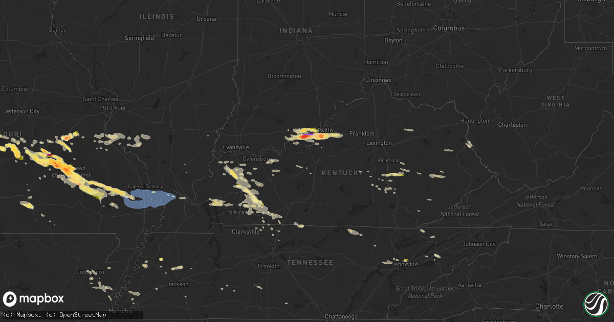
Hail Map in Kentucky on May 8, 2023
Get this storm
May 8 map
$229
one time, instant access
Download today. No call, no setup
Keep the $229
Bought the map and want the full workflow? Apply the entire $229 to a subscription within 7 days. None of it is wasted.
Every map, not just this one
This buys you this map. Subscription and you get every map we run, in the markets you choose from a few cities to whole states to nationwide. Plus real-time alerts the moment a storm fires.
Contact data
Name, contact info, occupancy, even credit band for addresses in the footprint. You go from where it hit to who to call.
Become the source they trust
Unlimited branding weather history reports on demand. You already have the documented answer ready for the property owner, and you are the one who showed up with it.
Property data and RoofTrace estimates
Pull up any address you have got, its value and the exact code rules for that jurisdiction, straight from One Click Code. Then RoofTrace estimates the squares, pitch, and roof value, priced the way you price.
Storm reports in Kentucky
Kentucky
| Date | Description |
|---|---|
| 05/08/202311:32 AM CDT | Several trees down throughout the city and county. |
| 05/08/20232:43 AM CDT | A local report indicates 1.75 inch wind near LOUISVILLE INT'L AIRPOR |
| 05/08/20232:39 AM CDT | A local report indicates 1.75 inch wind near 1 S SHIVELY |
| 05/08/20231:20 AM CDT | Media image shared of estimated quarter sized hail. Time estimated from radar. |
| 05/07/202311:50 PM CDT | Trees and powerlines down across the county. |
| 05/07/202311:36 PM CDT | Trees down in mayfield. |
| 05/07/202311:32 PM CDT | Corrects previous tstm wnd dmg report from 1 w paducah. Several trees down throughout the city and county. Corrected time. |
| 05/07/202311:15 PM CDT | Public social media picture relayed by broadcast media. |
| 05/07/202311:09 PM CDT | Corrects previous tstm wnd dmg report from 1 wsw la center. Trees and powerlines down across the county. |
| 05/07/202311:05 PM CDT | Roof/side of building damaged/removed from wind. Trees also down in the area. |
| 05/07/202310:06 PM CDT | Several trees down around the county. |
| 05/07/20239:39 PM CDT | Quarter sized hail in graham. |
| 05/07/20238:35 PM CDT | A local report indicates 1.25 inch wind near HANSON |
| 05/07/20238:04 PM CDT | Half dollar and quarter sized hail in dixon. |
All States Impacted by Hail Map on May 8, 2023
Cities Impacted by Hail Map on May 8, 2023
- Morocco, IN
- Brook, IN
- Carmi, IL
- Kountze, TX
- Lumberton, TX
- La Grange, TX
- Rolla, MO
- Newburg, MO
- Saint James, MO
- Salem, MO
- Cook Sta, MO
- Orange, TX
- Bridge City, TX
- Vidor, TX
- Cameron, LA
- Vinton, LA
- Butler, MO
- Amoret, MO
- Foster, MO
- Sulphur, LA
- Deepwater, MO
- Lowry City, MO
- Boss, MO
- Hackberry, LA
- Merkel, TX
- Springfield, MN
- Gravois Mills, MO
- Climax Springs, MO
- Edwards, MO
- Sleepy Eye, MN
- Comfrey, MN
- Muldoon, TX
- Schulenburg, TX
- Bunker, MO
- Tomball, TX
- Spring, TX
- Rich Hill, MO
- Rockville, MO
- Camdenton, MO
- Sunrise Beach, MO
- Roach, MO
- Winona, TX
- Waller, TX
- Hempstead, TX
- Marshall, TX
- Benton, LA
- Bossier City, LA
- Gladewater, TX
- Saratoga, TX
- Smithville, TX
- Clarkston, WA
- Lewiston, ID
- Wilmar, AR
- Plain Dealing, LA
- Livingston, TX
- Corrigan, TX
- Chester, TX
- Waskom, TX
- West Point, TX
- Longview, TX
- Garrison, TX
- Mount Enterprise, TX
- Jefferson, TX
- Malta, MT
- Camden, AR
- Huntsville, TX
- New Waverly, TX
- Waldo, AR
- McHenry, MS
- Giddings, TX
- Fayetteville, TX
- Ellinger, TX
- Chappell Hill, TX
- Washington, TX
- Brenham, TX
- Warren, AR
- Hallsville, TX
- Beaumont, TX
- Buckner, AR
- Thornton, AR
- Shepherd, TX
- Cleveland, TX
- Somerville, TX
- Weimar, TX
- Montgomery, TX
- Mooringsport, LA
- Shreveport, LA
- Big Sandy, TX
- Flatonia, TX
- Chidester, AR
- De Berry, TX
- Stephens, AR
- Brookshire, TX
- Coldspring, TX
- McNeil, AR
- Round Top, TX
- Burton, TX
- Navasota, TX
- Anderson, TX
- Karnack, TX
- Buna, TX
- Silsbee, TX
- Greenwood, LA
- Texarkana, AR
- Black, MO
- Crocker, MO
- Richland, MO
- Elk Point, SD
- Beldenville, WI
- Ellsworth, WI
- Spring Valley, WI
- Elmwood, WI
- Maiden Rock, WI
- Centerville, MO
- Montreal, MO
- Linn Creek, MO
- Stoutland, MO
- Hume, MO
- Fort Scott, KS
- Prescott, KS
- Schell City, MO
- Walker, MO
- Waynesville, MO
- Lesterville, MO
- Stockholm, WI
- Humble, TX
- Houston, TX
- Amboy, MN
- Mapleton, MN
- Good Thunder, MN
- Steelville, MO
- Terril, IA
- Milford, IA
- Briggs, TX
- Lampasas, TX
- Ruthven, IA
- Kempner, TX
- Graettinger, IA
- Emmetsburg, IA
- Estherville, IA
- London, TX
- Laquey, MO
- Menard, TX
- Armstrong, IA
- Richards, MO
- Deerfield, MO
- Junction, TX
- Nevada, MO
- Fenton, IA
- Bancroft, IA
- Swea City, IA
- Lone Rock, IA
- Jackson, MN
- Christoval, TX
- Spirit Lake, IA
- Eldorado, TX
- Alpha, MN
- Dunnell, MN
- Dolliver, IA
- Coleman, TX
- Santa Anna, TX
- Dixon, MO
- Devils Elbow, MO
- Elysian, MN
- Duke, MO
- Waterville, MN
- Edgar Springs, MO
- Janesville, MN
- Waseca, MN
- Bertram, TX
- Bourbon, MO
- Cylinder, IA
- West Bend, IA
- Whittemore, IA
- Smithland, IA
- Rodney, IA
- Mapleton, IA
- Oto, IA
- Hawkins, TX
- Tyler, TX
- Lindale, TX
- Annapolis, MO
- Ute, IA
- Charter Oak, IA
- Denison, IA
- Faribault, MN
- Nerstrand, MN
- Burnet, TX
- Des Arc, MO
- Milo, MO
- Dixon, KY
- Manitou, KY
- Slaughters, KY
- Sebree, KY
- El Dorado, AR
- De Queen, AR
- Horatio, AR
- Ballinger, TX
- Dow City, IA
- Arion, IA
- Ottosen, IA
- Mineola, TX
- Quitman, TX
- Hanson, KY
- Rowena, TX
- Ellington, MO
- Redford, MO
- Silva, MO
- Fredericktown, MO
- Greenville, MO
- Sheldon, MO
- Talpa, TX
- Moundville, MO
- Bangs, TX
- Brownwood, TX
- Madisonville, KY
- Earlington, KY
- Alba, TX
- San Saba, TX
- Piedmont, MO
- Vulcan, MO
- Cherokee, TX
- Early, TX
- May, TX
- Kirkman, IA
- Defiance, IA
- Irwin, IA
- Harlan, IA
- Brookesmith, TX
- Zephyr, TX
- Blanket, TX
- Glenallen, MO
- Patterson, MO
- Farlington, KS
- Arcadia, KS
- Marble Hill, MO
- Zalma, MO
- Mulberry, KS
- Willow Springs, MO
- Vanzant, MO
- Advance, MO
- Sturdivant, MO
- Brownwood, MO
- Bloomfield, MO
- Oran, MO
- Bell City, MO
- Essex, MO
- Sikeston, MO
- Vanduser, MO
- Bertrand, MO
- Benton, MO
- Charleston, MO
- Chaffee, MO
- Cape Girardeau, MO
- Whitewater, MO
- Scott City, MO
- Thebes, IL
- Tamms, IL
- Olive Branch, IL
- Miller City, IL
- Cherryville, MO
- Cairo, IL
- Villa Ridge, IL
- Mounds, IL
- Pulaski, IL
- Seligman, MO
- Pineville, MO
- Wickliffe, KY
- Mound City, IL
- Barlow, KY
- Olmsted, IL
- La Center, KY
- Kevil, KY
- Trinity, TX
- Saint Joseph, LA
- Waterproof, LA
- Eureka Springs, AR
- Killeen, TX
- Iberia, MO
- Mount Vernon, TX
- Sonora, TX
- Leasburg, MO
- Cuba, MO
- Cypress, TX
- Appleton City, MO
- Bixby, MO
- Hawley, TX
- Abilene, TX
- Bonne Terre, MO
- Kaiser, MO
- Ulman, MO
- Osage Beach, MO
- Lake Ozark, MO
- Brumley, MO
- Prairie Du Rocher, IL
- Castana, IA
- Manilla, IA
- Northfield, MN
- Kenyon, MN
- Morganfield, KY
- Nebo, KY
- Eden, TX
- Crosby, TX
- Huffman, TX
- San Angelo, TX
- Clyde, TX
- Gouldbusk, TX
- Goodhue, MN
- Red Wing, MN
- Welch, MN
- Florence, TX
- Goldsboro, TX
- Greenwell Springs, LA
- Richwoods, MO
- McGee, MO
- Cross Plains, TX
- Hanska, MN
- Saint James, MN
- Madelia, MN
- Valera, TX
- Waverly, KY
- Uniontown, KY
- White Oak, TX
- Worthington, MN
- Sullivan, MO
- Rolfe, IA
- Bradgate, IA
- Rutland, IA
- Mallard, IA
- Sanborn, MN
- Bay City, WI
- Greenville, KY
- Magnolia, AR
- Emerson, AR
- Hillsboro, MO
- De Soto, MO
- Ceylon, MN
- Lu Verne, IA
- Wesley, IA
- Algona, IA
- Fairmont, MN
- Burt, IA
- Sherburn, MN
- Ovalo, TX
- Burbank, SD
- Hockley, TX
- Hager City, WI
- Potosi, MO
- Clubb, MO
- Fort Stockton, TX
- Garden City, MN
- Vernon Center, MN
- Bastrop, TX
- Lewisburg, KY
- Burkett, TX
- Brady, TX
- Melvin, TX
- Festus, MO
- Fults, IL
- Valmeyer, IL
- Fort McKavett, TX
- Novice, TX
- Tuscola, TX
- Lawn, TX
- Clinton, LA
- Madison Lake, MN
- Anthon, IA
- Climbing Hill, IA
- Hornick, IA
- Pea Ridge, AR
- Bella Vista, AR
- Cross Timbers, MO
- Bloomsdale, MO
- Taylor, AR
- Rising Star, TX
- Peace Valley, MO
- West Plains, MO
- Licking, MO
- Baldwin, WI
- Sainte Genevieve, MO
- Puxico, MO
- Saint Robert, MO
- Vichy, MO
- Voss, TX
- Williamsville, MO
- Bucyrus, MO
- Jackson, NE
- Hubbard, NE
- Fordsville, KY
- Mount Holly, AR
- Elkton, KY
- Wappapello, MO
- White Plains, KY
- Graham, KY
- Arma, KS
- Cabool, MO
- Bronaugh, MO
- Winthrop, AR
- Haworth, OK
- Lake Crystal, MN
- Delavan, MN
- Corydon, KY
- Lillie, LA
- Junction City, AR
- Washburn, MO
- Eagle Lake, MN
- Conroe, TX
- Magnolia, TX
- Gilmer, TX
- Hampton, AR
- Fulton, KS
- Ponca, NE
- Corwith, IA
- Blackwell, TX
- Brinktown, MO
- Harwood, MO
- Osceola, MO
- Lowndes, MO
- Gipsy, MO
- Houston, MO
- Solo, MO
- Paige, TX
- Lakefield, MN
- Fort Leonard Wood, MO
- Dierks, AR
- Newhope, AR
- Valles Mines, MO
- Lodi, MO
- Jerome, MO
- Stover, MO
- New Richmond, WI
- Roberts, WI
- Uniontown, KS
- Pleasanton, KS
- Corydon, IN
- Elizabeth, IN
- New Middletown, IN
- Lanesville, IN
- Louisville, KY
- Laconia, IN
- New Albany, IN
- Fairdale, KY
- Fisherville, KY
- Simpsonville, KY
- Finchville, KY
- Georgetown, IN
- Russellville, KY
- Callender, IA
- Moorland, IA
- Fort Dodge, IA
- Story City, IA
- Boone, IA
- Stanhope, IA
- Rumsey, KY
- Calhoun, KY
- Zumbrota, MN
- Harrisburg, AR
- Jonesboro, AR
- Walsh, IL
- Ellis Grove, IL
- Chester, IL
- Pinckneyville, IL
- Coulterville, IL
- Medford, MN
- Stanford, KY
- Danville, KY
- Olaton, KY
- Bluejacket, OK
- Munford, TN
- Brighton, TN
- Atoka, TN
- Westmoreland, TN
- Adolphus, KY
- Rocksprings, TX
- Dilley, TX
- Sharon Grove, KY
- Bandera, TX
- Sonora, KY
- Cotulla, TX
- Humboldt, IA
- Bay, AR
- Weiner, AR
- Edinburg, TX
- Crofton, KY
- Hopkinsville, KY
- New Salisbury, IN
- Crandall, IN
- Ramsey, IN
- Sturgeon Lake, MN
- Kettle River, MN
- Cecilia, KY
- Eastview, KY
- Central, IN
- Leavenworth, IN
- Mauckport, IN
- Cannelton, IN
- Battletown, KY
- Rochelle, TX
- Richland Springs, TX
- Evansville, IL
- Red Bud, IL
- East Bernstadt, KY
- London, KY
- Shell Knob, MO
- Mertzon, TX
- Adairville, KY
- Springfield, TN
- Bono, AR
- Turrell, AR
- Gilmore, AR
- Leachville, AR
- Manila, AR
- Monette, AR
- Utopia, TX
- Paducah, KY
- West Paducah, KY
- Percy, IL
- Sparta, IL
- Cutler, IL
- Steeleville, IL
- Art, TX
- Pontotoc, TX
- Greenbrier, TN
- Brodhead, KY
- Mount Vernon, KY
- Irvine, KY
- Sabinal, TX
- Princeton, KY
- Garland, KS
- Uvalde, TX
- Rio Frio, TX
- Leakey, TX
- Vanderpool, TX
- Medina, TX
- Tarpley, TX
- Concan, TX
- Olmstead, KY
- Eddyville, KY
- Walnut, KS
- Payneville, KY
- Brandenburg, KY
- Eubank, KY
- Waynesburg, KY
- Franklin, KY
- Girard, KS
- Bremen, KY
- Pearsall, TX
- Johnstown, OH
- Central City, KY
- McKee, KY
- Huntsville, AR
- Crystal City, TX
- La Pryor, TX
- Friendship, TN
- Covington, TN
- Drummonds, TN
- Byrdstown, TN
- D Hanis, TX
- Halls, TN
- Valley Spring, TX
- Falls Of Rough, KY
- Dundee, KY
- Hartford, KY
- Stanchfield, MN
- Cambridge, MN
- Junction City, KY
- Parksville, KY
- Mindenmines, MO
- Couch, MO
- Cedar Hill, TN
- Mico, TX
- Crab Orchard, KY
- Cadiz, KY
- Cerulean, KY
- Brownsville, TN
- Carrier Mills, IL
- Lepanto, AR
- Trumann, AR
- Tyronza, AR
- Marked Tree, AR
- Baldwin, IL
- West Point, KY
- Shepherdsville, KY
- Camp Wood, TX
- Cedar Grove, TN
- Whitesville, KY
- Reynolds Station, KY
- Philpot, KY
- Hawesville, KY
- Trenton, TN
- Newbern, TN
- Milan, TN
- Humboldt, TN
- Lavinia, TN
- Finley, TN
- Lohn, TX
- Millington, TN
- Adams, TN
- Cloverport, KY
- Alton, MO
- Duncombe, IA
- Somerset, KY
- Mason, TX
- Dyersburg, TN
- Kuttawa, KY
- Hondo, TX
- Hunt, TX
- Webster City, IA
- Livingston, KY
- Utica, KY
- Pembroke, KY
- Sacramento, KY
- Trenton, KY
- Drakesboro, KY
- Powderly, KY
- Beech Creek, KY
- Auburn, KY
- Cottontown, TN
- White House, TN
- Cross Plains, TN
- Stonefort, IL
- Berea, KY
- Clay, KY
- Pocahontas, IA
- Havelock, IA
- Laurens, IA
- Sandgap, KY
- Hudson, KY
- Garfield, KY
- Big Clifty, KY
- Barksdale, TX
- Mozelle, KY
- Essie, KY
- Stinnett, KY
- Henderson, KY
- Hepler, KS
- Pipe Creek, TX
- Joiner, AR
- Dyess, AR
- Lake City, AR
- Golden, MO
- Rockwood, TX
- Robards, KY
- Owensboro, KY
- State University, AR
- Centertown, KY
- Beaver Dam, KY
- Rockport, KY
- Vinita, OK
- Black Oak, AR
- Knoxville, TN
- Dyer, TN
- Saint Francis, KS
- Bird City, KS
- Benkelman, NE
- Scott City, KS
- McDonald, KS
- Max, NE
- Colby, KS
- Oakley, KS
- Arlington, TN
- Arjay, KY
- Lost Creek, KY
- Clayhole, KY
- Emporia, KS
- Strong City, KS
- White Pine, TN
- Newport, TN
- Stark, KS
- Carrizo Springs, TX
- Abilene, KS
- Booneville, KY
- Beattyville, KY
- Owingsville, KY
- Sharpsburg, KY
- Cottonwood Falls, KS
- Elmdale, KS
- Goodlettsville, TN
- Hendersonville, TN
- Moorefield, KY
- Carlisle, KY
- Welda, KS
- Blue Mound, KS
- Calliham, TX
- Tilden, TX
- Jefferson City, TN
- Dandridge, TN
- Erie, KS
- Sunbright, TN
- Big Wells, TX
- Tazewell, TN
- Linden, TN
- English, IN
- Jamestown, TN
- Burlington, KS
- Waverly, KS
- Burnsville, MS
- Columbia, TN
- Culleoka, TN
- West Liberty, KY
- Flatgap, KY
- Henderson, TN
- Finger, TN
- Powell, TN
- Clinton, TN
- Jackson, KY
- Harrogate, TN
- Morristown, TN
- Centerville, KS
- Lafayette, TN
- Scottsville, KY
- Orlando, KY
- Batesville, TX
- Oak Ridge, TN
- Harriman, TN
- Oliver Springs, TN
- Milltown, IN
- Depauw, IN
- Shelbyville, KY
- Asherton, TX
- Fayetteville, TN
- Redfield, KS
- Bybee, TN
- Liberal, MO
- Ravenna, KY
- Sneedville, TN
- Thorn Hill, TN
- Hohenwald, TN
- Gadsden, TN
- Elsmore, KS
- Savonburg, KS
- Louisa, KY
- Pall Mall, TN
- Mapleton, KS
- Fort Gay, WV
- Winona, KS
- Monument, KS
- Brooks, KY
- Parks, NE
- Kincaid, KS
- Westphalia, KS
- Victoria, TX


