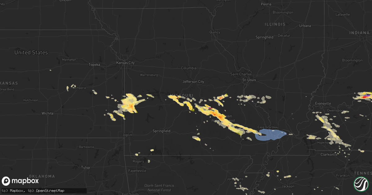
Hail Map in Missouri on May 8, 2023
Get this storm
May 8 map
$229
one time, instant access
Download today. No call, no setup
Keep the $229
Bought the map and want the full workflow? Apply the entire $229 to a subscription within 7 days. None of it is wasted.
Every map, not just this one
This buys you this map. Subscription and you get every map we run, in the markets you choose from a few cities to whole states to nationwide. Plus real-time alerts the moment a storm fires.
Contact data
Name, contact info, occupancy, even credit band for addresses in the footprint. You go from where it hit to who to call.
Become the source they trust
Unlimited branding weather history reports on demand. You already have the documented answer ready for the property owner, and you are the one who showed up with it.
Property data and RoofTrace estimates
Pull up any address you have got, its value and the exact code rules for that jurisdiction, straight from One Click Code. Then RoofTrace estimates the squares, pitch, and roof value, priced the way you price.
Storm reports in Missouri
Missouri
| Date | Description |
|---|---|
| 05/08/20236:59 PM CDT | A local report indicates 1.00 inch wind near LAKE SPRING |
| 05/08/20236:55 PM CDT | A local report indicates 1.50 inch wind near SAINT ROBERT |
| 05/08/20236:55 PM CDT | Delayed report 7 miles west of schell city of a few rounds of dime to quarter size hail. |
| 05/08/20236:55 PM CDT | A local report indicates 1.00 inch wind near 5 NNW LECOMA |
| 05/08/20236:55 PM CDT | Corrects previous hail report from 3 sw oates. Radar estimated time. Video of falling hail provided via twitter. |
| 05/08/20236:48 PM CDT | Via social media pic. |
| 05/08/20236:47 PM CDT | Report from mping: quarter |
| 05/08/20236:36 PM CDT | A local report indicates 1.50 inch wind near CROCKER |
| 05/08/20236:35 PM CDT | Radar estimated time. Occurred in buick... Mo. |
| 05/08/20236:30 PM CDT | Via social media pic. |
| 05/08/20236:25 PM CDT | Social media picture. |
| 05/08/20236:25 PM CDT | Delayed report of hail at least half dollar size hail west of crocker. |
| 05/08/20236:25 PM CDT | Quarter to ping pong size. |
| 05/08/20236:24 PM CDT | Via social media picture. |
| 05/08/20236:20 PM CDT | Via social media pic. |
| 05/08/20236:17 PM CDT | Relayed via social media. |
| 05/08/20236:15 PM CDT | Via social media pic. |
| 05/08/20236:14 PM CDT | Delayed report of hail slightly larger than golf balls in boss. |
| 05/08/20236:12 PM CDT | Via social media. |
| 05/08/20235:58 PM CDT | Lime to tennis ball sized hail in marcoot missouri. |
| 05/08/20235:46 PM CDT | A local report indicates 1.25 inch wind near 6 SE ROLLA |
| 05/08/20235:40 PM CDT | Delayed report. Coffman bend area of climax springs had a bunch of quarter sized hail. Time estimated via radar. |
| 05/08/20235:31 PM CDT | Corrects the time of previous hail report from 5 wnw stone hill. Confirmed this round of golf ball to tennis ball size hail fell around 530pm per social media. |
| 05/08/20235:30 PM CDT | Relayed via social media. |
| 05/08/20235:12 PM CDT | Via social media picture. |
| 05/08/20235:11 PM CDT | Report from mping: quarter |
| 05/08/20235:02 PM CDT | Some hail approaching half dollar size. |
| 05/08/20234:54 PM CDT | Delayed report. Near mounce which is near howe’s mill. 3 rounds about 20 minutes apart of large hail. Video shows hail falling at least baseball size. Additional hail |
| 05/08/20234:45 PM CDT | Chaser looked like golf balls possibly bigger... But no bigger than 2 inches. |
| 05/08/20234:20 PM CDT | Trained spotter measured hail ranging from 1.75 inches mostly... To a few 2 inches stones. |
| 05/08/20233:56 PM CDT | Quarter to nickel size hail. On mo 72. |
| 05/07/202311:11 PM CDT | Numerous trees down i-55 sb at the 86 mile marker. |
| 05/07/202311:02 PM CDT | Numerous trees down i-55 sb at the 86 mile marker. |
| 05/07/202310:45 PM CDT | Cgi asos reported a 62 kt wind gust. |
| 05/07/202310:45 PM CDT | A local report indicates 70 MPH wind near EAST PRAIRIE |
| 05/07/202310:44 PM CDT | Cgi asos peak gust of 61kt. |
| 05/07/202310:35 PM CDT | Estimated to at least 60 mph. |
| 05/07/202310:30 PM CDT | Nearly 100 power outages in the peace valley area. Time estimated via radar. |
| 05/07/202310:28 PM CDT | Tree fell on house. |
| 05/07/202310:14 PM CDT | Public weather station recorded a 72 mph wind gust at advance. |
| 05/07/202310:06 PM CDT | Report from mping: 3-inch tree limbs broken; power poles broken. |
| 05/07/202310:05 PM CDT | Tree fell across road in bloomfield. |
| 05/07/20239:49 PM CDT | Several trees down and reports of at least quarter sized hail. |
| 05/07/20239:46 PM CDT | Large tree uprooted and partially snapped. |
| 05/07/20239:45 PM CDT | S.o. Reports trees down countywide. |
| 05/07/20239:35 PM CDT | Via social media. |
| 05/07/20239:25 PM CDT | Reported at arrowhead campground. |
| 05/07/20239:10 PM CDT | Quarter sized hail covering the ground in cascade. |
| 05/07/20239:01 PM CDT | Delayed report of quarter size hail in the moundville area. |
| 05/07/20238:49 PM CDT | Relayed report of large trees down over highway 21. Time estimated by radar. |
| 05/07/20238:48 PM CDT | Via phone call. Between mm 91.5 and 81.5. Winds estimated 60 mph. |
| 05/07/20238:15 PM CDT | Delayed report of quarter size hail between nevada and fort scott kansas. Time estimated via radar. |
| 05/07/20238:00 PM CDT | Via broadcast media with a picture. |
| 05/07/20237:45 PM CDT | A local report indicates 1.25 inch wind near NEVADA |
| 05/07/20237:44 PM CDT | Public report submitted via social media. Report was accompanied by a photo. Time estimated by radar. |
| 05/07/20237:41 PM CDT | Via social media pic. |
| 05/07/20237:41 PM CDT | Corrects size of previous hail report from 5 wnw stone hill. Via social media pic. |
| 05/07/20237:36 PM CDT | Quarter sized hail covering the ground. |
| 05/07/20237:36 PM CDT | Report from mping: quarter |
| 05/07/20237:34 PM CDT | Report from mping: quarter |
| 05/07/20237:33 PM CDT | Report from mping: quarter |
| 05/07/20237:30 PM CDT | Reported via weather net. Reported from bixby country store. |
| 05/07/20237:30 PM CDT | Via email to contact. |
| 05/07/20237:25 PM CDT | A local report indicates 1.75 inch wind near 4 NW NEVADA |
| 05/07/20237:24 PM CDT | Via social media picture. |
| 05/07/20237:15 PM CDT | Report from mping: quarter |
| 05/07/20237:05 PM CDT | Delayed report 7 miles west of schell city of a few rounds of dime to quarter size hail. Large hail fell for about 20 minutes straight. |
| 05/07/20237:04 PM CDT | Dime to quarter size hail. Still hailing. |
| 05/07/20237:02 PM CDT | Report from mping: quarter |
| 05/07/20237:00 PM CDT | Radar estimated time. Video of falling hail provided via twitter. |
| 05/07/20237:00 PM CDT | Nickel to quarter size hail. |
All States Impacted by Hail Map on May 8, 2023
Cities Impacted by Hail Map on May 8, 2023
- Morocco, IN
- Brook, IN
- Carmi, IL
- Kountze, TX
- Lumberton, TX
- La Grange, TX
- Rolla, MO
- Newburg, MO
- Saint James, MO
- Salem, MO
- Cook Sta, MO
- Orange, TX
- Bridge City, TX
- Vidor, TX
- Cameron, LA
- Vinton, LA
- Butler, MO
- Amoret, MO
- Foster, MO
- Sulphur, LA
- Deepwater, MO
- Lowry City, MO
- Boss, MO
- Hackberry, LA
- Merkel, TX
- Springfield, MN
- Gravois Mills, MO
- Climax Springs, MO
- Edwards, MO
- Sleepy Eye, MN
- Comfrey, MN
- Muldoon, TX
- Schulenburg, TX
- Bunker, MO
- Tomball, TX
- Spring, TX
- Rich Hill, MO
- Rockville, MO
- Camdenton, MO
- Sunrise Beach, MO
- Roach, MO
- Winona, TX
- Waller, TX
- Hempstead, TX
- Marshall, TX
- Benton, LA
- Bossier City, LA
- Gladewater, TX
- Saratoga, TX
- Smithville, TX
- Clarkston, WA
- Lewiston, ID
- Wilmar, AR
- Plain Dealing, LA
- Livingston, TX
- Corrigan, TX
- Chester, TX
- Waskom, TX
- West Point, TX
- Longview, TX
- Garrison, TX
- Mount Enterprise, TX
- Jefferson, TX
- Malta, MT
- Camden, AR
- Huntsville, TX
- New Waverly, TX
- Waldo, AR
- McHenry, MS
- Giddings, TX
- Fayetteville, TX
- Ellinger, TX
- Chappell Hill, TX
- Washington, TX
- Brenham, TX
- Warren, AR
- Hallsville, TX
- Beaumont, TX
- Buckner, AR
- Thornton, AR
- Shepherd, TX
- Cleveland, TX
- Somerville, TX
- Weimar, TX
- Montgomery, TX
- Mooringsport, LA
- Shreveport, LA
- Big Sandy, TX
- Flatonia, TX
- Chidester, AR
- De Berry, TX
- Stephens, AR
- Brookshire, TX
- Coldspring, TX
- McNeil, AR
- Round Top, TX
- Burton, TX
- Navasota, TX
- Anderson, TX
- Karnack, TX
- Buna, TX
- Silsbee, TX
- Greenwood, LA
- Texarkana, AR
- Black, MO
- Crocker, MO
- Richland, MO
- Elk Point, SD
- Beldenville, WI
- Ellsworth, WI
- Spring Valley, WI
- Elmwood, WI
- Maiden Rock, WI
- Centerville, MO
- Montreal, MO
- Linn Creek, MO
- Stoutland, MO
- Hume, MO
- Fort Scott, KS
- Prescott, KS
- Schell City, MO
- Walker, MO
- Waynesville, MO
- Lesterville, MO
- Stockholm, WI
- Humble, TX
- Houston, TX
- Amboy, MN
- Mapleton, MN
- Good Thunder, MN
- Steelville, MO
- Terril, IA
- Milford, IA
- Briggs, TX
- Lampasas, TX
- Ruthven, IA
- Kempner, TX
- Graettinger, IA
- Emmetsburg, IA
- Estherville, IA
- London, TX
- Laquey, MO
- Menard, TX
- Armstrong, IA
- Richards, MO
- Deerfield, MO
- Junction, TX
- Nevada, MO
- Fenton, IA
- Bancroft, IA
- Swea City, IA
- Lone Rock, IA
- Jackson, MN
- Christoval, TX
- Spirit Lake, IA
- Eldorado, TX
- Alpha, MN
- Dunnell, MN
- Dolliver, IA
- Coleman, TX
- Santa Anna, TX
- Dixon, MO
- Devils Elbow, MO
- Elysian, MN
- Duke, MO
- Waterville, MN
- Edgar Springs, MO
- Janesville, MN
- Waseca, MN
- Bertram, TX
- Bourbon, MO
- Cylinder, IA
- West Bend, IA
- Whittemore, IA
- Smithland, IA
- Rodney, IA
- Mapleton, IA
- Oto, IA
- Hawkins, TX
- Tyler, TX
- Lindale, TX
- Annapolis, MO
- Ute, IA
- Charter Oak, IA
- Denison, IA
- Faribault, MN
- Nerstrand, MN
- Burnet, TX
- Des Arc, MO
- Milo, MO
- Dixon, KY
- Manitou, KY
- Slaughters, KY
- Sebree, KY
- El Dorado, AR
- De Queen, AR
- Horatio, AR
- Ballinger, TX
- Dow City, IA
- Arion, IA
- Ottosen, IA
- Mineola, TX
- Quitman, TX
- Hanson, KY
- Rowena, TX
- Ellington, MO
- Redford, MO
- Silva, MO
- Fredericktown, MO
- Greenville, MO
- Sheldon, MO
- Talpa, TX
- Moundville, MO
- Bangs, TX
- Brownwood, TX
- Madisonville, KY
- Earlington, KY
- Alba, TX
- San Saba, TX
- Piedmont, MO
- Vulcan, MO
- Cherokee, TX
- Early, TX
- May, TX
- Kirkman, IA
- Defiance, IA
- Irwin, IA
- Harlan, IA
- Brookesmith, TX
- Zephyr, TX
- Blanket, TX
- Glenallen, MO
- Patterson, MO
- Farlington, KS
- Arcadia, KS
- Marble Hill, MO
- Zalma, MO
- Mulberry, KS
- Willow Springs, MO
- Vanzant, MO
- Advance, MO
- Sturdivant, MO
- Brownwood, MO
- Bloomfield, MO
- Oran, MO
- Bell City, MO
- Essex, MO
- Sikeston, MO
- Vanduser, MO
- Bertrand, MO
- Benton, MO
- Charleston, MO
- Chaffee, MO
- Cape Girardeau, MO
- Whitewater, MO
- Scott City, MO
- Thebes, IL
- Tamms, IL
- Olive Branch, IL
- Miller City, IL
- Cherryville, MO
- Cairo, IL
- Villa Ridge, IL
- Mounds, IL
- Pulaski, IL
- Seligman, MO
- Pineville, MO
- Wickliffe, KY
- Mound City, IL
- Barlow, KY
- Olmsted, IL
- La Center, KY
- Kevil, KY
- Trinity, TX
- Saint Joseph, LA
- Waterproof, LA
- Eureka Springs, AR
- Killeen, TX
- Iberia, MO
- Mount Vernon, TX
- Sonora, TX
- Leasburg, MO
- Cuba, MO
- Cypress, TX
- Appleton City, MO
- Bixby, MO
- Hawley, TX
- Abilene, TX
- Bonne Terre, MO
- Kaiser, MO
- Ulman, MO
- Osage Beach, MO
- Lake Ozark, MO
- Brumley, MO
- Prairie Du Rocher, IL
- Castana, IA
- Manilla, IA
- Northfield, MN
- Kenyon, MN
- Morganfield, KY
- Nebo, KY
- Eden, TX
- Crosby, TX
- Huffman, TX
- San Angelo, TX
- Clyde, TX
- Gouldbusk, TX
- Goodhue, MN
- Red Wing, MN
- Welch, MN
- Florence, TX
- Goldsboro, TX
- Greenwell Springs, LA
- Richwoods, MO
- McGee, MO
- Cross Plains, TX
- Hanska, MN
- Saint James, MN
- Madelia, MN
- Valera, TX
- Waverly, KY
- Uniontown, KY
- White Oak, TX
- Worthington, MN
- Sullivan, MO
- Rolfe, IA
- Bradgate, IA
- Rutland, IA
- Mallard, IA
- Sanborn, MN
- Bay City, WI
- Greenville, KY
- Magnolia, AR
- Emerson, AR
- Hillsboro, MO
- De Soto, MO
- Ceylon, MN
- Lu Verne, IA
- Wesley, IA
- Algona, IA
- Fairmont, MN
- Burt, IA
- Sherburn, MN
- Ovalo, TX
- Burbank, SD
- Hockley, TX
- Hager City, WI
- Potosi, MO
- Clubb, MO
- Fort Stockton, TX
- Garden City, MN
- Vernon Center, MN
- Bastrop, TX
- Lewisburg, KY
- Burkett, TX
- Brady, TX
- Melvin, TX
- Festus, MO
- Fults, IL
- Valmeyer, IL
- Fort McKavett, TX
- Novice, TX
- Tuscola, TX
- Lawn, TX
- Clinton, LA
- Madison Lake, MN
- Anthon, IA
- Climbing Hill, IA
- Hornick, IA
- Pea Ridge, AR
- Bella Vista, AR
- Cross Timbers, MO
- Bloomsdale, MO
- Taylor, AR
- Rising Star, TX
- Peace Valley, MO
- West Plains, MO
- Licking, MO
- Baldwin, WI
- Sainte Genevieve, MO
- Puxico, MO
- Saint Robert, MO
- Vichy, MO
- Voss, TX
- Williamsville, MO
- Bucyrus, MO
- Jackson, NE
- Hubbard, NE
- Fordsville, KY
- Mount Holly, AR
- Elkton, KY
- Wappapello, MO
- White Plains, KY
- Graham, KY
- Arma, KS
- Cabool, MO
- Bronaugh, MO
- Winthrop, AR
- Haworth, OK
- Lake Crystal, MN
- Delavan, MN
- Corydon, KY
- Lillie, LA
- Junction City, AR
- Washburn, MO
- Eagle Lake, MN
- Conroe, TX
- Magnolia, TX
- Gilmer, TX
- Hampton, AR
- Fulton, KS
- Ponca, NE
- Corwith, IA
- Blackwell, TX
- Brinktown, MO
- Harwood, MO
- Osceola, MO
- Lowndes, MO
- Gipsy, MO
- Houston, MO
- Solo, MO
- Paige, TX
- Lakefield, MN
- Fort Leonard Wood, MO
- Dierks, AR
- Newhope, AR
- Valles Mines, MO
- Lodi, MO
- Jerome, MO
- Stover, MO
- New Richmond, WI
- Roberts, WI
- Uniontown, KS
- Pleasanton, KS
- Corydon, IN
- Elizabeth, IN
- New Middletown, IN
- Lanesville, IN
- Louisville, KY
- Laconia, IN
- New Albany, IN
- Fairdale, KY
- Fisherville, KY
- Simpsonville, KY
- Finchville, KY
- Georgetown, IN
- Russellville, KY
- Callender, IA
- Moorland, IA
- Fort Dodge, IA
- Story City, IA
- Boone, IA
- Stanhope, IA
- Rumsey, KY
- Calhoun, KY
- Zumbrota, MN
- Harrisburg, AR
- Jonesboro, AR
- Walsh, IL
- Ellis Grove, IL
- Chester, IL
- Pinckneyville, IL
- Coulterville, IL
- Medford, MN
- Stanford, KY
- Danville, KY
- Olaton, KY
- Bluejacket, OK
- Munford, TN
- Brighton, TN
- Atoka, TN
- Westmoreland, TN
- Adolphus, KY
- Rocksprings, TX
- Dilley, TX
- Sharon Grove, KY
- Bandera, TX
- Sonora, KY
- Cotulla, TX
- Humboldt, IA
- Bay, AR
- Weiner, AR
- Edinburg, TX
- Crofton, KY
- Hopkinsville, KY
- New Salisbury, IN
- Crandall, IN
- Ramsey, IN
- Sturgeon Lake, MN
- Kettle River, MN
- Cecilia, KY
- Eastview, KY
- Central, IN
- Leavenworth, IN
- Mauckport, IN
- Cannelton, IN
- Battletown, KY
- Rochelle, TX
- Richland Springs, TX
- Evansville, IL
- Red Bud, IL
- East Bernstadt, KY
- London, KY
- Shell Knob, MO
- Mertzon, TX
- Adairville, KY
- Springfield, TN
- Bono, AR
- Turrell, AR
- Gilmore, AR
- Leachville, AR
- Manila, AR
- Monette, AR
- Utopia, TX
- Paducah, KY
- West Paducah, KY
- Percy, IL
- Sparta, IL
- Cutler, IL
- Steeleville, IL
- Art, TX
- Pontotoc, TX
- Greenbrier, TN
- Brodhead, KY
- Mount Vernon, KY
- Irvine, KY
- Sabinal, TX
- Princeton, KY
- Garland, KS
- Uvalde, TX
- Rio Frio, TX
- Leakey, TX
- Vanderpool, TX
- Medina, TX
- Tarpley, TX
- Concan, TX
- Olmstead, KY
- Eddyville, KY
- Walnut, KS
- Payneville, KY
- Brandenburg, KY
- Eubank, KY
- Waynesburg, KY
- Franklin, KY
- Girard, KS
- Bremen, KY
- Pearsall, TX
- Johnstown, OH
- Central City, KY
- McKee, KY
- Huntsville, AR
- Crystal City, TX
- La Pryor, TX
- Friendship, TN
- Covington, TN
- Drummonds, TN
- Byrdstown, TN
- D Hanis, TX
- Halls, TN
- Valley Spring, TX
- Falls Of Rough, KY
- Dundee, KY
- Hartford, KY
- Stanchfield, MN
- Cambridge, MN
- Junction City, KY
- Parksville, KY
- Mindenmines, MO
- Couch, MO
- Cedar Hill, TN
- Mico, TX
- Crab Orchard, KY
- Cadiz, KY
- Cerulean, KY
- Brownsville, TN
- Carrier Mills, IL
- Lepanto, AR
- Trumann, AR
- Tyronza, AR
- Marked Tree, AR
- Baldwin, IL
- West Point, KY
- Shepherdsville, KY
- Camp Wood, TX
- Cedar Grove, TN
- Whitesville, KY
- Reynolds Station, KY
- Philpot, KY
- Hawesville, KY
- Trenton, TN
- Newbern, TN
- Milan, TN
- Humboldt, TN
- Lavinia, TN
- Finley, TN
- Lohn, TX
- Millington, TN
- Adams, TN
- Cloverport, KY
- Alton, MO
- Duncombe, IA
- Somerset, KY
- Mason, TX
- Dyersburg, TN
- Kuttawa, KY
- Hondo, TX
- Hunt, TX
- Webster City, IA
- Livingston, KY
- Utica, KY
- Pembroke, KY
- Sacramento, KY
- Trenton, KY
- Drakesboro, KY
- Powderly, KY
- Beech Creek, KY
- Auburn, KY
- Cottontown, TN
- White House, TN
- Cross Plains, TN
- Stonefort, IL
- Berea, KY
- Clay, KY
- Pocahontas, IA
- Havelock, IA
- Laurens, IA
- Sandgap, KY
- Hudson, KY
- Garfield, KY
- Big Clifty, KY
- Barksdale, TX
- Mozelle, KY
- Essie, KY
- Stinnett, KY
- Henderson, KY
- Hepler, KS
- Pipe Creek, TX
- Joiner, AR
- Dyess, AR
- Lake City, AR
- Golden, MO
- Rockwood, TX
- Robards, KY
- Owensboro, KY
- State University, AR
- Centertown, KY
- Beaver Dam, KY
- Rockport, KY
- Vinita, OK
- Black Oak, AR
- Knoxville, TN
- Dyer, TN
- Saint Francis, KS
- Bird City, KS
- Benkelman, NE
- Scott City, KS
- McDonald, KS
- Max, NE
- Colby, KS
- Oakley, KS
- Arlington, TN
- Arjay, KY
- Lost Creek, KY
- Clayhole, KY
- Emporia, KS
- Strong City, KS
- White Pine, TN
- Newport, TN
- Stark, KS
- Carrizo Springs, TX
- Abilene, KS
- Booneville, KY
- Beattyville, KY
- Owingsville, KY
- Sharpsburg, KY
- Cottonwood Falls, KS
- Elmdale, KS
- Goodlettsville, TN
- Hendersonville, TN
- Moorefield, KY
- Carlisle, KY
- Welda, KS
- Blue Mound, KS
- Calliham, TX
- Tilden, TX
- Jefferson City, TN
- Dandridge, TN
- Erie, KS
- Sunbright, TN
- Big Wells, TX
- Tazewell, TN
- Linden, TN
- English, IN
- Jamestown, TN
- Burlington, KS
- Waverly, KS
- Burnsville, MS
- Columbia, TN
- Culleoka, TN
- West Liberty, KY
- Flatgap, KY
- Henderson, TN
- Finger, TN
- Powell, TN
- Clinton, TN
- Jackson, KY
- Harrogate, TN
- Morristown, TN
- Centerville, KS
- Lafayette, TN
- Scottsville, KY
- Orlando, KY
- Batesville, TX
- Oak Ridge, TN
- Harriman, TN
- Oliver Springs, TN
- Milltown, IN
- Depauw, IN
- Shelbyville, KY
- Asherton, TX
- Fayetteville, TN
- Redfield, KS
- Bybee, TN
- Liberal, MO
- Ravenna, KY
- Sneedville, TN
- Thorn Hill, TN
- Hohenwald, TN
- Gadsden, TN
- Elsmore, KS
- Savonburg, KS
- Louisa, KY
- Pall Mall, TN
- Mapleton, KS
- Fort Gay, WV
- Winona, KS
- Monument, KS
- Brooks, KY
- Parks, NE
- Kincaid, KS
- Westphalia, KS
- Victoria, TX


