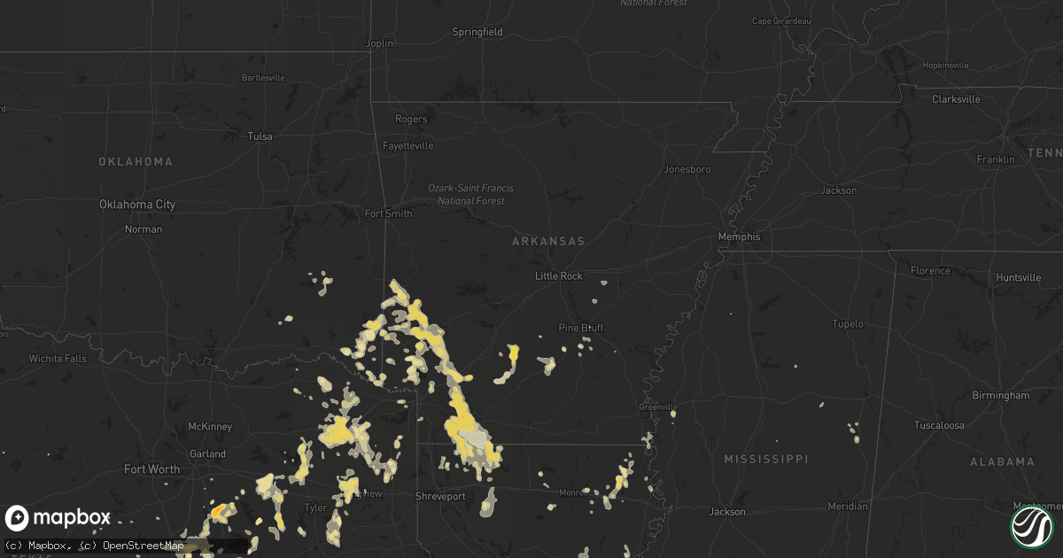
Hail Map in Mississippi on May 7, 2012
Get this storm
May 7 map
$229
one time, instant access
Download today. No call, no setup
Keep the $229
Bought the map and want the full workflow? Apply the entire $229 to a subscription within 7 days. None of it is wasted.
Every map, not just this one
This buys you this map. Subscription and you get every map we run, in the markets you choose from a few cities to whole states to nationwide. Plus real-time alerts the moment a storm fires.
Contact data
Name, contact info, occupancy, even credit band for addresses in the footprint. You go from where it hit to who to call.
Become the source they trust
Unlimited branding weather history reports on demand. You already have the documented answer ready for the property owner, and you are the one who showed up with it.
Property data and RoofTrace estimates
Pull up any address you have got, its value and the exact code rules for that jurisdiction, straight from One Click Code. Then RoofTrace estimates the squares, pitch, and roof value, priced the way you price.
Storm reports in Mississippi
Mississippi
| Date | Description |
|---|---|
| 05/07/20124:05 PM CDT | Trees were downed along springfield road...beau pre road...and artman road. |
| 05/07/20124:00 PM CDT | Trees were downed on col john pitchford parkway and john r dunkin drive. A tree fell on a house on pinewood circle. |
| 05/07/20124:00 PM CDT | A tree was downed on morgantown road |
| 05/07/20123:55 PM CDT | Large limbs were downed causing road blockage near marion ave...copiah lincoln community college...and pinewood cir. |
| 05/07/20123:40 PM CDT | A tree had fallen on a home on spears road...which had caused an injury. |
| 05/07/20123:39 PM CDT | Trees were blown down. The locations were as follows around yazoo city. Dark corner road...courts road...steed lane...fox road...rebecca road...eden midway...scotland r |
| 05/07/20121:40 PM CDT | Trees were blown down along jeff davis road |
| 05/07/20121:30 PM CDT | A shed was blown over on highway 481 near leesburg |
| 05/07/20121:10 PM CDT | Power lines were blown down across i-55 near woodrow wilson drive. Three lanes of the interstate are closed. |
| 05/07/20121:10 PM CDT | 2 trees down in the county. One in the city of vicksburg and another one down in the county. |
| 05/07/20121:00 PM CDT | A couple trees were downed along gluckstadt road |
| 05/07/201212:45 PM CDT | One tree down at junction of south montgomery and poorhouse roads |
| 05/07/201212:43 PM CDT | Trees down on powerlines on old highway 12 |
All States Impacted by Hail Map on May 7, 2012
Cities Impacted by Hail Map on May 7, 2012
- Greenville, FL
- Madison, FL
- Fredericksburg, TX
- Epps, LA
- Pioneer, LA
- Boerne, TX
- Melvin, TX
- Brady, TX
- Ennis, TX
- Pearsall, TX
- Pineville, LA
- Thornton, TX
- Harleton, TX
- Marshall, TX
- Jefferson, TX
- Choudrant, LA
- Farmerville, LA
- Dryden, TX
- Theriot, LA
- Doss, TX
- Jacksonville, FL
- Lamesa, TX
- Welch, TX
- Lockesburg, AR
- Winchester, IN
- Parker City, IN
- Selma, IN
- Ridgeville, IN
- Muncie, IN
- Albany, IN
- Farmland, IN
- Malakoff, TX
- Eustace, TX
- Mabank, TX
- Pecos, TX
- Texarkana, AR
- Yorktown, IN
- Green Cove Springs, FL
- Garden City, TX
- Big Lake, TX
- Artesia, NM
- Lake Arthur, NM
- Detroit, TX
- Clarksville, TX
- Hope, AR
- Morral, OH
- Harpster, OH
- Paint Rock, TX
- Eden, TX
- Rice, TX
- Marion, OH
- Nevada, OH
- Monroe, LA
- Jasper, AL
- Eagletown, OK
- Broken Bow, OK
- Watson, OK
- Laredo, TX
- Malone, TX
- Vienna, OH
- Girard, OH
- Youngstown, OH
- Hubbard, OH
- Dierks, AR
- Chidester, AR
- Lowellville, OH
- Campbell, OH
- Eagle Pass, TX
- Quemado, TX
- Kemp, TX
- Kaufman, TX
- Rushville, OH
- Crystal City, TX
- Haworth, OK
- De Queen, AR
- Gillham, AR
- Lovington, NM
- Maljamar, NM
- Glen Rose, TX
- Franklin, LA
- Jeanerette, LA
- Sondheimer, LA
- Seminole, TX
- Hobbs, NM
- Mason, TX
- Menard, TX
- London, TX
- Springport, IN
- Mount Pleasant, TX
- Winfield, TX
- Pittsburg, TX
- Denham Springs, LA
- Sterling City, TX
- Leander, TX
- Austin, TX
- Cedar Park, TX
- Hondo, TX
- Mico, TX
- Castroville, TX
- Rio Medina, TX
- Homer, LA
- Yantis, TX
- Como, TX
- Umpire, AR
- Mena, AR
- Sparkman, AR
- Eldorado, TX
- Geneva, OH
- Austinburg, OH
- Batesville, TX
- La Pryor, TX
- Big Wells, TX
- Junction, TX
- Athens, TX
- Murchison, TX
- Mayhill, NM
- Weed, NM
- Hope, NM
- Macon, MS
- Hamilton, TX
- Jefferson, OH
- Ashtabula, OH
- Axtell, TX
- Linden, TX
- Emory, TX
- Shongaloo, LA
- Springhill, LA
- Sarepta, LA
- Andrews, TX
- Quitman, TX
- Fulton, AR
- Nashville, AR
- Rochelle, TX
- San Angelo, TX
- Hubbard, TX
- Hillsboro, TX
- Bynum, TX
- Emmet, AR
- Big Sandy, TX
- White Oak, TX
- Kilgore, TX
- Longview, TX
- Gladewater, TX
- Gilmer, TX
- Murfreesboro, AR
- Richland Springs, TX
- San Saba, TX
- Ozona, TX
- Gatesville, TX
- Abbott, TX
- Waskom, TX
- Saint Henry, OH
- Fort Recovery, OH
- Coldwater, OH
- North Salem, IN
- Lizton, IN
- Pittsboro, IN
- Brownsburg, IN
- Fairfield, TX
- Teague, TX
- Oakwood, TX
- Streetman, TX
- Alba, TX
- Wilton, AR
- Gould, AR
- Edinburg, PA
- Penelope, TX
- Clinton, LA
- Slaughter, LA
- Tyler, TX
- Overton, TX
- Winona, TX
- Buchanan Dam, TX
- Llano, TX
- Jbsa Lackland, TX
- Fort Stockton, TX
- Saint Johns, FL
- Ashdown, AR
- Mineral Springs, AR
- Vidalia, LA
- Barnhart, TX
- Mertzon, TX
- Castell, TX
- Valley Spring, TX
- Art, TX
- Pontotoc, TX
- Comfort, TX
- Taylor, AR
- Magnolia, AR
- Waldo, AR
- Stamps, AR
- Lancaster, OH
- Pyote, TX
- Barstow, TX
- Lampasas, TX
- Daytona Beach, FL
- New Smyrna Beach, FL
- Deland, FL
- Frankston, TX
- Horatio, AR
- Canton, TX
- Wills Point, TX
- Edgewood, TX
- Mount Calm, TX
- Adrian, PA
- New Bethlehem, PA
- Dayton, PA
- Templeton, PA
- Kittanning, PA
- Salt Flat, TX
- Pipe Creek, TX
- Grannis, AR
- Abbeville, LA
- Maurice, LA
- Eros, LA
- Live Oak, FL
- Lee, FL
- Pickton, TX
- Mineola, TX
- Asherton, TX
- Carrizo Springs, TX
- Camp Wood, TX
- Caledonia, OH
- Troup, TX
- Jacksonville, TX
- Bogata, TX
- Wortham, TX
- Ambrose, GA
- Douglas, GA
- Prairie Hill, TX
- Coolidge, TX
- Natchez, MS
- Saint Francisville, LA
- Ashland, KY
- Rush, KY
- Paris, TX
- Pattonville, TX
- Ravenna, OH
- Brooksville, MS
- Webster, FL
- Mart, TX
- Riesel, TX
- Rayville, LA
- Barksdale, TX
- Ringgold, LA
- Dubberly, LA
- Jamestown, LA
- Brackettville, TX
- Niles, OH
- Masury, OH
- Hermitage, PA
- Warren, OH
- Farrell, PA
- Sharon, PA
- Brookfield, OH
- New Wilmington, PA
- Wheatland, PA
- West Middlesex, PA
- Manor, TX
- Colorado City, TX
- Westbrook, TX
- Lewisville, AR
- Buckner, AR
- Groesbeck, TX
- McGuffey, OH
- Dola, OH
- Harrod, OH
- Ada, OH
- Alger, OH
- Forest, OH
- Kenton, OH
- Rison, AR
- Chatfield, TX
- Orange Park, FL
- Seagraves, TX
- Deltona, FL
- Thornton, AR
- Fordyce, AR
- Emerson, AR
- Haynesville, LA
- Medina, TX
- Bagwell, TX
- Milford, TX
- Corsicana, TX
- Breckenridge, TX
- Graham, TX
- Ocala, FL
- Batesville, MS
- Devine, TX
- Woodworth, LA
- Lecompte, LA
- Alexandria, LA
- Forest Hill, LA
- Dawson, TX
- Marksville, LA
- Effie, LA
- Newhope, AR
- Washington, AR
- McCaskill, AR
- Trafalgar, IN
- Morgantown, IN
- Oak Grove, LA
- Blacklick, OH
- New Albany, OH
- Hughes Springs, TX
- Texarkana, TX
- Hooks, TX
- Comstock, TX
- New Plymouth, OH
- La Coste, TX
- Fowler, OH
- Transfer, PA
- Sharpsville, PA
- Burghill, OH
- Atlanta, TX
- Medina, OH
- Lodi, OH
- Larue, TX
- Greens Fork, IN
- Talihina, OK
- Nashoba, OK
- Upper Sandusky, OH
- Bandera, TX
- Rocksprings, TX
- Selman City, TX
- Arp, TX
- Mcconnelsville, OH
- Blue Rock, OH
- Alamo, GA
- Arkadelphia, AR
- Fredonia, TX
- Voca, TX
- Big Spring, TX
- Lancaster, TX
- Ferris, TX
- Rushsylvania, OH
- Ridgeway, OH
- Huntsville, OH
- Bellefontaine, OH
- Belle Center, OH
- Idabel, OK
- Harrisonburg, LA
- Marlin, TX
- Elm Mott, TX
- Waco, TX
- Cookville, TX
- Lone Star, TX
- Naples, TX
- Omaha, TX
- Daingerfield, TX
- Leland, MS
- Greenville, MS
- Lindale, TX
- Grand Saline, TX
- Winnsboro, TX
- Cotton Valley, LA
- Plain Dealing, LA
- San Antonio, TX
- Benton, LA
- Olla, LA
- Pulaski, PA
- Mercer, PA
- Boston, GA
- Antlers, OK
- Hastings, FL
- Minden, LA
- Willow City, TX
- Liberty Hill, TX
- Ozan, AR
- Thomasville, GA
- Houma, LA
- Bucyrus, OH
- Coyanosa, TX
- Imperial, TX
- Saint Marys, OH
- New Knoxville, OH
- Montezuma, OH
- Wapakoneta, OH
- Botkins, OH
- Maria Stein, OH
- Celina, OH
- New Bremen, OH
- Cortland, OH
- Atascosa, TX
- Powell, TX
- Kingsville, OH
- Roswell, NM
- Aimwell, LA
- Columbia, LA
- Enterprise, LA
- Cove, AR
- Hatfield, AR
- Garvin, OK
- Mount Vernon, TX
- Starkville, MS
- Sturgis, MS
- Bradley, AR
- Cameron, TX
- Rock Creek, OH
- Fruitvale, TX
- Clayton, LA
- Loraine, TX
- McCall Creek, MS
- Zachary, LA
- Ethel, LA
- Walker, LA
- Greenwell Springs, LA
- Pride, LA
- Monticello, FL
- Annona, TX
- Chrisman, IL
- Avinger, TX
- Jonesville, LA
- Moore, TX
- Yoakum, TX
- Kosciusko, MS
- Sanford, FL
- Winthrop, AR
- Millersview, TX
- Miles, TX
- Mereta, TX
- Wall, TX
- Hext, TX
- Vancourt, TX
- Eola, TX
- Goodfellow Afb, TX
- Bristolville, OH
- Donalsonville, GA
- Iron City, GA
- Bigfoot, TX
- Richland, TX
- Bunnell, FL
- Center Point, TX
- Kerrville, TX
- Frost, TX
- Shelby, OH
- Galion, OH
- Crestline, OH
- Star City, AR
- Carlisle, AR
- Finley, OK
- Moyers, OK
- Mayo, FL
- Gurdon, AR
- Scroggins, TX
- Midkiff, TX
- Athens, LA
- Dilley, TX
- Heflin, LA
- Avery, TX
- Wildwood, FL
- Oxford, FL
- Paige, TX
- Ben Wheeler, TX
- La Rue, OH
- Mount Victory, OH
- Ivan, AR
- Kingsland, AR
- Pine Bluff, AR
- Albany, TX
- Portland, IN
- Anderson, IN
- Union City, IN
- Alexandria, IN
- Daleville, IN
- Altamonte Springs, FL
- Navarre, OH
- Beach City, OH
- Tow, TX
- Guilford, IN
- Barry, TX
- Blooming Grove, TX
- Sarver, PA
- Woodville, MS
- Inverness, FL
- Wickes, AR
- Gibsland, LA
- Castor, LA
- Sugar Grove, OH
- Bremen, OH
- Bluffton, TX
- Burnet, TX
- Bertram, TX
- Freeport, PA
- Leechburg, PA
- Langley, AR
- Smithville, OK
- Prescott, AR
- Rosston, AR
- Vandervoort, AR
- Blevins, AR
- Columbus, AR
- Lumber City, GA
- Ford City, PA
- Cadogan, PA
- Foreman, AR
- Sealy, TX
- Cat Spring, TX
- Orlando, FL
- Tuskahoma, OK
- Mansfield, OH
- Ashland, OH
- Ocilla, GA
- McDonald, OH
- Mansfield, TX
- Purdon, TX
- Mertens, TX
- Clayton, OK
- Lawrenceburg, IN
- Christmas, FL
- Oviedo, FL
- Leesburg, TX
- Cherokee, TX
- Alpine, TX
- Columbus, OH
- Eudora, AR
- Oak Ridge, LA
- Volant, PA
- Carlton, TX
- Hico, TX
- Glenwood, GA
- Ansonia, OH
- Hollandale, MS
- Lakeland, FL
- Dade City, FL
- Bainbridge, GA
- Brinson, GA
- New Ulm, TX
- New Bloomington, OH
- Fort Hood, TX
- Van, TX
- Calhoun City, MS
- Lytle, TX
- D Hanis, TX
- Powderly, TX
- Haughton, LA
- Carthage, AR
- Elgin, TX
- Mentone, TX
- Baskin, LA
- Delhi, LA
- Youngsville, LA
- Hazen, AR
- Ferriday, LA
- Reagan, TX
- Erath, LA
- New Iberia, LA
- Melbourne, FL
- Ore City, TX
- Kerens, TX
- Callahan, FL
- Hilliard, FL
- Sonora, TX
- De Kalb, TX
- Anson, TX
- Hamlin, TX
- Tallulah, LA
- Cabot, PA
- Shuqualak, MS
- Saratoga, AR
- New Castle, PA
- McCaulley, TX
- Sylvester, TX
- Sweetwater, TX
- Ojo Caliente, NM
- Mangham, LA
- Pataskala, OH
- Elkton, FL
- McRae Helena, GA
- Seagoville, TX
- Balmorhea, TX
- Calvert, TX
- Clifton, TX
- Bullard, TX
- Bivins, TX
- Palestine, TX
- Montalba, TX
- Poteet, TX
- Von Ormy, TX
- Del Rio, TX
- Deport, TX
- Lometa, TX
- Danville, IN
- England, AR
- Cowansville, PA
- Brookhaven, MS
- Cleburne, TX
- Spring Church, PA
- Apollo, PA
- Vandergrift, PA
- Talco, TX
- Bluff Dale, TX
- Fredericksburg, OH
- Dundee, OH
- Apopka, FL
- Saint Joseph, LA
- Waterproof, LA
- New Philadelphia, OH
- Stone Creek, OH
- Grandview, TX
- Moundsville, WV
- Powhatan Point, OH
- Wray, GA
- Saxonburg, PA
- Falmouth, IN
- Transylvania, LA
- Summerfield, FL
- Bastrop, TX
- Uvalde, TX
- Somerville, TX
- Floral City, FL


