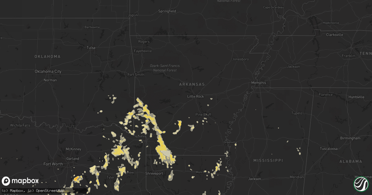
Hail Map in Louisiana on May 7, 2012
Get this storm
May 7 map
$229
one time, instant access
Download today. No call, no setup
Keep the $229
Bought the map and want the full workflow? Apply the entire $229 to a subscription within 7 days. None of it is wasted.
Every map, not just this one
This buys you this map. Subscription and you get every map we run, in the markets you choose from a few cities to whole states to nationwide. Plus real-time alerts the moment a storm fires.
Contact data
Name, contact info, occupancy, even credit band for addresses in the footprint. You go from where it hit to who to call.
Become the source they trust
Unlimited branding weather history reports on demand. You already have the documented answer ready for the property owner, and you are the one who showed up with it.
Property data and RoofTrace estimates
Pull up any address you have got, its value and the exact code rules for that jurisdiction, straight from One Click Code. Then RoofTrace estimates the squares, pitch, and roof value, priced the way you price.
Storm reports in Louisiana
Louisiana
| Date | Description |
|---|---|
| 05/07/20126:00 PM CDT | Public reported quarter sized hail. |
| 05/07/20126:00 PM CDT | Trees down on highway 955. |
| 05/07/20121:50 PM CDT | Multiple trees down near mayfield elementary on highway 190. |
| 05/07/201212:55 PM CDT | Trees down on duckworth road |
| 05/07/201212:36 PM CDT | Tree blown down along sand road |
| 05/06/20129:30 PM CDT | Tree down across the road near the town of bienville. |
| 05/06/20128:45 PM CDT | Trees reported down in minden. |
| 05/06/20128:00 PM CDT | Alot of trees down across northern parts of webster parish. |
All States Impacted by Hail Map on May 7, 2012
Cities Impacted by Hail Map on May 7, 2012
- Greenville, FL
- Madison, FL
- Fredericksburg, TX
- Epps, LA
- Pioneer, LA
- Boerne, TX
- Melvin, TX
- Brady, TX
- Ennis, TX
- Pearsall, TX
- Pineville, LA
- Thornton, TX
- Harleton, TX
- Marshall, TX
- Jefferson, TX
- Choudrant, LA
- Farmerville, LA
- Dryden, TX
- Theriot, LA
- Doss, TX
- Jacksonville, FL
- Lamesa, TX
- Welch, TX
- Lockesburg, AR
- Winchester, IN
- Parker City, IN
- Selma, IN
- Ridgeville, IN
- Muncie, IN
- Albany, IN
- Farmland, IN
- Malakoff, TX
- Eustace, TX
- Mabank, TX
- Pecos, TX
- Texarkana, AR
- Yorktown, IN
- Green Cove Springs, FL
- Garden City, TX
- Big Lake, TX
- Artesia, NM
- Lake Arthur, NM
- Detroit, TX
- Clarksville, TX
- Hope, AR
- Morral, OH
- Harpster, OH
- Paint Rock, TX
- Eden, TX
- Rice, TX
- Marion, OH
- Nevada, OH
- Monroe, LA
- Jasper, AL
- Eagletown, OK
- Broken Bow, OK
- Watson, OK
- Laredo, TX
- Malone, TX
- Vienna, OH
- Girard, OH
- Youngstown, OH
- Hubbard, OH
- Dierks, AR
- Chidester, AR
- Lowellville, OH
- Campbell, OH
- Eagle Pass, TX
- Quemado, TX
- Kemp, TX
- Kaufman, TX
- Rushville, OH
- Crystal City, TX
- Haworth, OK
- De Queen, AR
- Gillham, AR
- Lovington, NM
- Maljamar, NM
- Glen Rose, TX
- Franklin, LA
- Jeanerette, LA
- Sondheimer, LA
- Seminole, TX
- Hobbs, NM
- Mason, TX
- Menard, TX
- London, TX
- Springport, IN
- Mount Pleasant, TX
- Winfield, TX
- Pittsburg, TX
- Denham Springs, LA
- Sterling City, TX
- Leander, TX
- Austin, TX
- Cedar Park, TX
- Hondo, TX
- Mico, TX
- Castroville, TX
- Rio Medina, TX
- Homer, LA
- Yantis, TX
- Como, TX
- Umpire, AR
- Mena, AR
- Sparkman, AR
- Eldorado, TX
- Geneva, OH
- Austinburg, OH
- Batesville, TX
- La Pryor, TX
- Big Wells, TX
- Junction, TX
- Athens, TX
- Murchison, TX
- Mayhill, NM
- Weed, NM
- Hope, NM
- Macon, MS
- Hamilton, TX
- Jefferson, OH
- Ashtabula, OH
- Axtell, TX
- Linden, TX
- Emory, TX
- Shongaloo, LA
- Springhill, LA
- Sarepta, LA
- Andrews, TX
- Quitman, TX
- Fulton, AR
- Nashville, AR
- Rochelle, TX
- San Angelo, TX
- Hubbard, TX
- Hillsboro, TX
- Bynum, TX
- Emmet, AR
- Big Sandy, TX
- White Oak, TX
- Kilgore, TX
- Longview, TX
- Gladewater, TX
- Gilmer, TX
- Murfreesboro, AR
- Richland Springs, TX
- San Saba, TX
- Ozona, TX
- Gatesville, TX
- Abbott, TX
- Waskom, TX
- Saint Henry, OH
- Fort Recovery, OH
- Coldwater, OH
- North Salem, IN
- Lizton, IN
- Pittsboro, IN
- Brownsburg, IN
- Fairfield, TX
- Teague, TX
- Oakwood, TX
- Streetman, TX
- Alba, TX
- Wilton, AR
- Gould, AR
- Edinburg, PA
- Penelope, TX
- Clinton, LA
- Slaughter, LA
- Tyler, TX
- Overton, TX
- Winona, TX
- Buchanan Dam, TX
- Llano, TX
- Jbsa Lackland, TX
- Fort Stockton, TX
- Saint Johns, FL
- Ashdown, AR
- Mineral Springs, AR
- Vidalia, LA
- Barnhart, TX
- Mertzon, TX
- Castell, TX
- Valley Spring, TX
- Art, TX
- Pontotoc, TX
- Comfort, TX
- Taylor, AR
- Magnolia, AR
- Waldo, AR
- Stamps, AR
- Lancaster, OH
- Pyote, TX
- Barstow, TX
- Lampasas, TX
- Daytona Beach, FL
- New Smyrna Beach, FL
- Deland, FL
- Frankston, TX
- Horatio, AR
- Canton, TX
- Wills Point, TX
- Edgewood, TX
- Mount Calm, TX
- Adrian, PA
- New Bethlehem, PA
- Dayton, PA
- Templeton, PA
- Kittanning, PA
- Salt Flat, TX
- Pipe Creek, TX
- Grannis, AR
- Abbeville, LA
- Maurice, LA
- Eros, LA
- Live Oak, FL
- Lee, FL
- Pickton, TX
- Mineola, TX
- Asherton, TX
- Carrizo Springs, TX
- Camp Wood, TX
- Caledonia, OH
- Troup, TX
- Jacksonville, TX
- Bogata, TX
- Wortham, TX
- Ambrose, GA
- Douglas, GA
- Prairie Hill, TX
- Coolidge, TX
- Natchez, MS
- Saint Francisville, LA
- Ashland, KY
- Rush, KY
- Paris, TX
- Pattonville, TX
- Ravenna, OH
- Brooksville, MS
- Webster, FL
- Mart, TX
- Riesel, TX
- Rayville, LA
- Barksdale, TX
- Ringgold, LA
- Dubberly, LA
- Jamestown, LA
- Brackettville, TX
- Niles, OH
- Masury, OH
- Hermitage, PA
- Warren, OH
- Farrell, PA
- Sharon, PA
- Brookfield, OH
- New Wilmington, PA
- Wheatland, PA
- West Middlesex, PA
- Manor, TX
- Colorado City, TX
- Westbrook, TX
- Lewisville, AR
- Buckner, AR
- Groesbeck, TX
- McGuffey, OH
- Dola, OH
- Harrod, OH
- Ada, OH
- Alger, OH
- Forest, OH
- Kenton, OH
- Rison, AR
- Chatfield, TX
- Orange Park, FL
- Seagraves, TX
- Deltona, FL
- Thornton, AR
- Fordyce, AR
- Emerson, AR
- Haynesville, LA
- Medina, TX
- Bagwell, TX
- Milford, TX
- Corsicana, TX
- Breckenridge, TX
- Graham, TX
- Ocala, FL
- Batesville, MS
- Devine, TX
- Woodworth, LA
- Lecompte, LA
- Alexandria, LA
- Forest Hill, LA
- Dawson, TX
- Marksville, LA
- Effie, LA
- Newhope, AR
- Washington, AR
- McCaskill, AR
- Trafalgar, IN
- Morgantown, IN
- Oak Grove, LA
- Blacklick, OH
- New Albany, OH
- Hughes Springs, TX
- Texarkana, TX
- Hooks, TX
- Comstock, TX
- New Plymouth, OH
- La Coste, TX
- Fowler, OH
- Transfer, PA
- Sharpsville, PA
- Burghill, OH
- Atlanta, TX
- Medina, OH
- Lodi, OH
- Larue, TX
- Greens Fork, IN
- Talihina, OK
- Nashoba, OK
- Upper Sandusky, OH
- Bandera, TX
- Rocksprings, TX
- Selman City, TX
- Arp, TX
- Mcconnelsville, OH
- Blue Rock, OH
- Alamo, GA
- Arkadelphia, AR
- Fredonia, TX
- Voca, TX
- Big Spring, TX
- Lancaster, TX
- Ferris, TX
- Rushsylvania, OH
- Ridgeway, OH
- Huntsville, OH
- Bellefontaine, OH
- Belle Center, OH
- Idabel, OK
- Harrisonburg, LA
- Marlin, TX
- Elm Mott, TX
- Waco, TX
- Cookville, TX
- Lone Star, TX
- Naples, TX
- Omaha, TX
- Daingerfield, TX
- Leland, MS
- Greenville, MS
- Lindale, TX
- Grand Saline, TX
- Winnsboro, TX
- Cotton Valley, LA
- Plain Dealing, LA
- San Antonio, TX
- Benton, LA
- Olla, LA
- Pulaski, PA
- Mercer, PA
- Boston, GA
- Antlers, OK
- Hastings, FL
- Minden, LA
- Willow City, TX
- Liberty Hill, TX
- Ozan, AR
- Thomasville, GA
- Houma, LA
- Bucyrus, OH
- Coyanosa, TX
- Imperial, TX
- Saint Marys, OH
- New Knoxville, OH
- Montezuma, OH
- Wapakoneta, OH
- Botkins, OH
- Maria Stein, OH
- Celina, OH
- New Bremen, OH
- Cortland, OH
- Atascosa, TX
- Powell, TX
- Kingsville, OH
- Roswell, NM
- Aimwell, LA
- Columbia, LA
- Enterprise, LA
- Cove, AR
- Hatfield, AR
- Garvin, OK
- Mount Vernon, TX
- Starkville, MS
- Sturgis, MS
- Bradley, AR
- Cameron, TX
- Rock Creek, OH
- Fruitvale, TX
- Clayton, LA
- Loraine, TX
- McCall Creek, MS
- Zachary, LA
- Ethel, LA
- Walker, LA
- Greenwell Springs, LA
- Pride, LA
- Monticello, FL
- Annona, TX
- Chrisman, IL
- Avinger, TX
- Jonesville, LA
- Moore, TX
- Yoakum, TX
- Kosciusko, MS
- Sanford, FL
- Winthrop, AR
- Millersview, TX
- Miles, TX
- Mereta, TX
- Wall, TX
- Hext, TX
- Vancourt, TX
- Eola, TX
- Goodfellow Afb, TX
- Bristolville, OH
- Donalsonville, GA
- Iron City, GA
- Bigfoot, TX
- Richland, TX
- Bunnell, FL
- Center Point, TX
- Kerrville, TX
- Frost, TX
- Shelby, OH
- Galion, OH
- Crestline, OH
- Star City, AR
- Carlisle, AR
- Finley, OK
- Moyers, OK
- Mayo, FL
- Gurdon, AR
- Scroggins, TX
- Midkiff, TX
- Athens, LA
- Dilley, TX
- Heflin, LA
- Avery, TX
- Wildwood, FL
- Oxford, FL
- Paige, TX
- Ben Wheeler, TX
- La Rue, OH
- Mount Victory, OH
- Ivan, AR
- Kingsland, AR
- Pine Bluff, AR
- Albany, TX
- Portland, IN
- Anderson, IN
- Union City, IN
- Alexandria, IN
- Daleville, IN
- Altamonte Springs, FL
- Navarre, OH
- Beach City, OH
- Tow, TX
- Guilford, IN
- Barry, TX
- Blooming Grove, TX
- Sarver, PA
- Woodville, MS
- Inverness, FL
- Wickes, AR
- Gibsland, LA
- Castor, LA
- Sugar Grove, OH
- Bremen, OH
- Bluffton, TX
- Burnet, TX
- Bertram, TX
- Freeport, PA
- Leechburg, PA
- Langley, AR
- Smithville, OK
- Prescott, AR
- Rosston, AR
- Vandervoort, AR
- Blevins, AR
- Columbus, AR
- Lumber City, GA
- Ford City, PA
- Cadogan, PA
- Foreman, AR
- Sealy, TX
- Cat Spring, TX
- Orlando, FL
- Tuskahoma, OK
- Mansfield, OH
- Ashland, OH
- Ocilla, GA
- McDonald, OH
- Mansfield, TX
- Purdon, TX
- Mertens, TX
- Clayton, OK
- Lawrenceburg, IN
- Christmas, FL
- Oviedo, FL
- Leesburg, TX
- Cherokee, TX
- Alpine, TX
- Columbus, OH
- Eudora, AR
- Oak Ridge, LA
- Volant, PA
- Carlton, TX
- Hico, TX
- Glenwood, GA
- Ansonia, OH
- Hollandale, MS
- Lakeland, FL
- Dade City, FL
- Bainbridge, GA
- Brinson, GA
- New Ulm, TX
- New Bloomington, OH
- Fort Hood, TX
- Van, TX
- Calhoun City, MS
- Lytle, TX
- D Hanis, TX
- Powderly, TX
- Haughton, LA
- Carthage, AR
- Elgin, TX
- Mentone, TX
- Baskin, LA
- Delhi, LA
- Youngsville, LA
- Hazen, AR
- Ferriday, LA
- Reagan, TX
- Erath, LA
- New Iberia, LA
- Melbourne, FL
- Ore City, TX
- Kerens, TX
- Callahan, FL
- Hilliard, FL
- Sonora, TX
- De Kalb, TX
- Anson, TX
- Hamlin, TX
- Tallulah, LA
- Cabot, PA
- Shuqualak, MS
- Saratoga, AR
- New Castle, PA
- McCaulley, TX
- Sylvester, TX
- Sweetwater, TX
- Ojo Caliente, NM
- Mangham, LA
- Pataskala, OH
- Elkton, FL
- McRae Helena, GA
- Seagoville, TX
- Balmorhea, TX
- Calvert, TX
- Clifton, TX
- Bullard, TX
- Bivins, TX
- Palestine, TX
- Montalba, TX
- Poteet, TX
- Von Ormy, TX
- Del Rio, TX
- Deport, TX
- Lometa, TX
- Danville, IN
- England, AR
- Cowansville, PA
- Brookhaven, MS
- Cleburne, TX
- Spring Church, PA
- Apollo, PA
- Vandergrift, PA
- Talco, TX
- Bluff Dale, TX
- Fredericksburg, OH
- Dundee, OH
- Apopka, FL
- Saint Joseph, LA
- Waterproof, LA
- New Philadelphia, OH
- Stone Creek, OH
- Grandview, TX
- Moundsville, WV
- Powhatan Point, OH
- Wray, GA
- Saxonburg, PA
- Falmouth, IN
- Transylvania, LA
- Summerfield, FL
- Bastrop, TX
- Uvalde, TX
- Somerville, TX
- Floral City, FL


