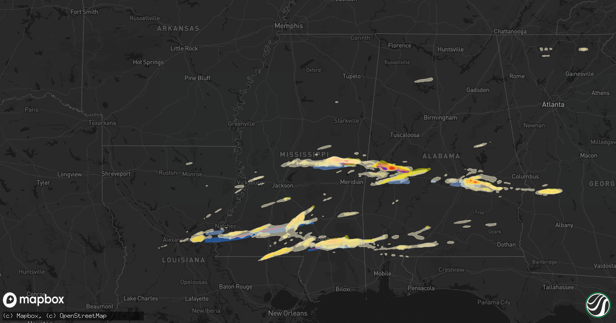
Hail Map in Mississippi on May 6, 2026
Get this storm
May 6 map
$229
one time, instant access
Download today. No call, no setup
Keep the $229
Bought the map and want the full workflow? Apply the entire $229 to a subscription within 7 days. None of it is wasted.
Every map, not just this one
This buys you this map. Subscription and you get every map we run, in the markets you choose from a few cities to whole states to nationwide. Plus real-time alerts the moment a storm fires.
Contact data
Name, contact info, occupancy, even credit band for addresses in the footprint. You go from where it hit to who to call.
Become the source they trust
Unlimited branding weather history reports on demand. You already have the documented answer ready for the property owner, and you are the one who showed up with it.
Property data and RoofTrace estimates
Pull up any address you have got, its value and the exact code rules for that jurisdiction, straight from One Click Code. Then RoofTrace estimates the squares, pitch, and roof value, priced the way you price.
Storm reports in Mississippi
Mississippi
| Date | Description |
|---|---|
| 05/06/20266:55 PM CDT | Confirmed tornado - a tds was observed on the 88d radar network. |
| 05/06/20266:45 PM CDT | A local report indicates 1.75 inch wind near 2 N Clem |
| 05/06/20266:41 PM CDT | Confirmed tornado - a tds was observed on the 88d radar network. |
| 05/06/20266:23 PM CDT | Law enforcement reported multiple trees down across lawrence county. |
| 05/06/20266:10 PM CDT | A local report indicates 1.75 inch wind near 1 SSE De Kalb |
| 05/06/20266:10 PM CDT | Numerous trees were snapped and uprooted and blocking roads. This damage report and related photos were relayed through social media. |
| 05/06/20266:00 PM CDT | Photo of tree down across highway 27 south of lexie. Possible tornado damage. |
| 05/06/20266:00 PM CDT | Video showed several trees downed near stallings bridge road. Possible tornado damage. |
| 05/06/20266:00 PM CDT | 2 to 2.75 hail at hwy 16 and 493. Trees also down in the area. |
| 05/06/20265:54 PM CDT | A local report indicates 1.25 inch wind near 2 NW Tylertown |
| 05/06/20265:54 PM CDT | A local report indicates 1.50 inch wind near 1 NNE Tylertown |
| 05/06/20265:51 PM CDT | Emergency manager reported trees down on hwy 25 and pea size hail. |
| 05/06/20265:51 PM CDT | Emergency manager reported golf to baseball size hail near rd 452. |
| 05/06/20265:45 PM CDT | Pictures of damage to steel awning on county road 505 were relayed. |
| 05/06/20265:45 PM CDT | Several trees were snapped and uprooted in the bloomo community. This was relayed through social media. |
| 05/06/20265:40 PM CDT | Numerous trees were snapped and uprooted and blocking roads in the williamsville community. This damage report and related photos were relayed through social media. |
| 05/06/20265:39 PM CDT | Emergency manager reported golf ball size hail at hwy 21 s and hwy 488. |
| 05/06/20265:35 PM CDT | A picture on social media showed golf ball sized hail in osyka. |
| 05/06/20265:02 PM CDT | Trees down on lines in e madison. |
| 05/06/20265:00 PM CDT | This was reported by a nearby convenience store... And video was taken of the hail as well. |
| 05/05/202611:23 PM CDT | Marion county ema reports that trees were down and a house destroyed on ridgewood drive. |
| 05/05/20269:15 PM CDT | A concentrated area of tree and power line damage occurred along wilson road. One tree fell onto a home. |
| 05/05/20269:10 PM CDT | A concentrated area of tree and power line damage occurred along salem church road. |
| 05/05/20268:58 PM CDT | Storm chaser reported power flashes and flying debris at ms hwy 42 near fate ward rd. |
| 05/05/20268:26 PM CDT | Confirmed tornado - a tds was observed on the 88d radar network. |
| 05/05/20268:14 PM CDT | Confirmed tornado - a tds was observed on the 88d radar network. |
| 05/05/20268:03 PM CDT | Confirmed tornado - a tds was observed on the 88d radar network. |
| 05/05/20267:57 PM CDT | Confirmed tornado - a tds was observed on the 88d radar network. |
| 05/05/20267:49 PM CDT | Confirmed tornado - a tds was observed on the 88d radar network. |
| 05/05/20267:37 PM CDT | Confirmed tornado - a tds was observed on the 88d radar network. |
| 05/05/20267:26 PM CDT | Emergency manager reported damage to office building. |
| 05/05/20267:12 PM CDT | Confirmed tornado - a tds was observed on the 88d radar network. |
| 05/05/20267:10 PM CDT | Confirmed tornado - a tds was observed on the 88d radar network. |
| 05/05/20267:07 PM CDT | Corrects time of previous tornado report from 2 n purvis and updated damage info. Major damage occurred to buildings along ms highway 589 and old highway 11. An office |
| 05/05/20267:02 PM CDT | Confirmed tornado - a tds was observed on the 88d radar network. |
Cities Impacted by Hail Map on May 6, 2026
- Sonora, TX
- Ozona, TX
- Junction, TX
- Menard, TX
- London, TX
- Roosevelt, TX
- Mason, TX
- Art, TX
- Castell, TX
- Llano, TX
- Buchanan Dam, TX
- Doss, TX
- Harper, TX
- Burnet, TX
- Kingsland, TX
- Fredericksburg, TX
- Bluffton, TX
- Willow City, TX
- Bertram, TX
- Round Mountain, TX
- Johnson City, TX
- Spicewood, TX
- Ward, AL
- York, AL
- Jachin, AL
- Demopolis, AL
- Deville, LA
- Linden, AL
- Gallion, AL
- Faunsdale, AL
- Thomaston, AL
- Uniontown, AL
- Safford, AL
- Jonesville, LA
- Monterey, LA
- Vidalia, LA
- Selma, AL
- Tyler, AL
- Natchez, MS
- Double Springs, AL
- Prattville, AL
- Addison, AL
- Houston, AL
- Autaugaville, AL
- Canton, MS
- Lowndesboro, AL
- Hope Hull, AL
- Montgomery, AL
- Meadville, MS
- Camden, MS
- Logan, AL
- Arley, AL
- Cullman, AL
- Vinemont, AL
- Bentonia, MS
- Bude, MS
- Carthage, MS
- Pike Road, AL
- Lena, MS
- Walnut Grove, MS
- McCall Creek, MS
- Brookhaven, MS
- Kentwood, LA
- Greensburg, LA
- Shorter, AL
- Union, MS
- Philadelphia, MS
- Hardaway, AL
- Cecil, AL
- Fitzpatrick, AL
- Jena, LA
- Effie, LA
- Magnolia, MS
- Osyka, MS
- Harrisonburg, LA
- Center Point, LA
- Tuskegee, AL
- Mccomb, MS
- Mathews, AL
- Union Springs, AL
- Clayton, LA
- Tylertown, MS
- Collinsville, MS
- De Kalb, MS
- Hurtsboro, AL
- Midway, AL
- Marksville, LA
- Thomasville, AL
- Fort Davis, AL
- Summit, MS
- Jayess, MS
- Hazlehurst, MS
- Crystal Springs, MS
- Ellijay, GA
- Vicksburg, MS
- Monticello, MS
- Porterville, MS
- Scooba, MS
- Foxworth, MS
- Columbia, MS
- Oak Vale, MS
- Silver Creek, MS
- Florence, MS
- Prentiss, MS
- Kokomo, MS
- Crosby, MS
- Epes, AL
- Emelle, AL
- Newhebron, MS
- Carson, MS
- Harrisville, MS
- Downsville, LA
- Sandy Hook, MS
- Roxie, MS
- Talking Rock, GA
- Acme, LA
- Woodville, MS
- Gloster, MS
- Sumrall, MS
- Helen, GA
- Sautee Nacoochee, GA
- Mize, MS
- Magee, MS
- Mount Olive, MS
- Livingston, AL
- Boligee, AL
- Wetumpka, AL
- Collins, MS
- Gainesville, AL
- Braxton, MS
- Farmerville, LA
- Sterlington, LA
- Lumberton, MS
- Columbia, LA
- Purvis, MS
- Hattiesburg, MS
- Forkland, AL
- Eclectic, AL
- Millbrook, AL
- New Augusta, MS
- Petal, MS
- Richton, MS
- Greensboro, AL
- Newbern, AL
- Hineston, LA
- Tallassee, AL
- Elmer, LA
- Sawyerville, AL
- Bogue Chitto, MS
- Beaumont, MS
- Lauderdale, MS
- Toomsuba, MS
- Mangham, LA
- Marion, AL
- Smithdale, MS
- Cuba, AL
- Leakesville, MS
- Neely, MS
- Noxapater, MS
- Pineville, LA
- Kosciusko, MS
- State Line, MS
- McCool, MS
- Louisville, MS
- Tuskegee Institute, AL
- Ruth, MS
- Little Rock, MS
- Redwood, MS
- Alexander City, AL
- Kellyton, AL
- Sontag, MS
- Goodwater, AL
- McLain, MS
- Bellamy, AL
- Vinegar Bend, AL
- Fruitdale, AL
- Hatchechubbee, AL
- Daleville, MS
- Tibbie, AL
- Deer Park, AL
- McIntosh, AL
- Seale, AL
- Pittsview, AL
- Tallulah, LA
- Sunflower, AL
- Fort Mitchell, AL
- Wagarville, AL
- Seminary, MS
- Cusseta, GA
- Omaha, GA
- Edwards, MS
- Richland, GA
- Jackson, AL
- Lumpkin, GA
- Americus, GA
- Buena Vista, GA
- Preston, GA
- Ellaville, GA
- Laurel, MS
- Shubuta, MS
- Evergreen, AL
- Repton, AL
- Bailey, MS
- Meridian, MS
- Waynesboro, MS
- Plains, GA
- Soso, MS
- Preston, MS
- Taylorsville, MS
- Brantley, AL
- Rutledge, AL
- Luverne, AL
- Greenville, AL
- Bassfield, MS
- Heidelberg, MS
- Louin, MS
- Bay Springs, MS
- Rose Hill, MS
- Citronelle, AL
- Little River, AL
- Uriah, AL
- Mount Vernon, AL
- Stockton, AL
- Lisman, AL
- Atmore, AL
- Brewton, AL
- Marion Junction, AL
- Castleberry, AL
- Woodland, MS
- Houston, MS
- Daviston, AL
- Brooklyn, MS
- Dozier, AL
- Frisco City, AL
- Glenwood, AL
- Monroeville, AL
- Lenox, AL
- Range, AL
- Ariton, AL
- Brundidge, AL
- Bay Minette, AL
- Perdido, AL
- McDavid, FL
- Andalusia, AL


