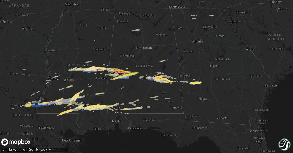
Hail Map in Alabama on May 6, 2026
Get this storm
May 6 map
$229
one time, instant access
Download today. No call, no setup
Keep the $229
Bought the map and want the full workflow? Apply the entire $229 to a subscription within 7 days. None of it is wasted.
Every map, not just this one
This buys you this map. Subscription and you get every map we run, in the markets you choose from a few cities to whole states to nationwide. Plus real-time alerts the moment a storm fires.
Contact data
Name, contact info, occupancy, even credit band for addresses in the footprint. You go from where it hit to who to call.
Become the source they trust
Unlimited branding weather history reports on demand. You already have the documented answer ready for the property owner, and you are the one who showed up with it.
Property data and RoofTrace estimates
Pull up any address you have got, its value and the exact code rules for that jurisdiction, straight from One Click Code. Then RoofTrace estimates the squares, pitch, and roof value, priced the way you price.
Storm reports in Alabama
Alabama
| Date | Description |
|---|---|
| 05/06/20266:52 PM CDT | Broadcast media relayed viewer video of ping pong ball sized hail near boligee. |
| 05/06/20265:45 PM CDT | Hail of at least quarter sized observed by broadcast meteorologist just north of cr 2 in macon county. |
| 05/06/20265:45 PM CDT | Quarter sized hail reported by the public in fort davis around 5:45 pm. Time and location approximate. |
| 05/06/20265:33 PM CDT | Location approximate. |
| 05/06/20265:18 PM CDT | Baseball sized hail reported along interstate 85 at exit 10 reported by trained spotter. Time approximate. |
| 05/06/20265:12 PM CDT | Quarter sized hail reported by the public at mellow mushroom. Time approximate. |
| 05/06/20265:07 PM CDT | Public reported a portion of a tree fell on a car near pike road close to u.s. 231. Time and location approximate. |
| 05/06/20265:05 PM CDT | Report and photo of trees down... Some impacting power lines near trotman road west of pike road. |
| 05/06/20265:04 PM CDT | Report of trees down along snowdoun chambers road southeast of montgomery. Time and location approximate. |
| 05/06/20265:03 PM CDT | Report of tennis ball size hail reported along taylor road near eastchase mall. Time approximate. |
| 05/06/20265:02 PM CDT | Mgm 062202z 35014g50kt 1/2sm +tsra fg bkn018 bkn034 ovc044 22/21 a2991 rmk ao2 pk wnd 33050/2155 wshft 2146 ltg dsnt n-se p0059 t02170211. |
| 05/06/20264:59 PM CDT | Tree down along west wareingwood drive in montgomery. Time approximate. |
| 05/06/20264:55 PM CDT | Corrected to show peak gust time of 2155z. Mgm 062202z 35014g50kt 1/2sm +tsra fg bkn018 bkn034 ovc044 22/21 a2991 rmk ao2 pk wnd 33050/2155 wshft 2146 ltg dsnt n-se p00 |
| 05/06/20264:53 PM CDT | Tree reported down across 180 west blvd west of montgomery. Time approxmiate. |
| 05/06/20264:51 PM CDT | Montgomery county ema reports 3303 power outages... 7 trees down... 4 power lines down and 5 traffic lights out. Time and location approximate. |
| 05/06/20262:30 PM CDT | Trees down across highway 69 south of gallion. |
| 05/06/20266:12 AM CDT | Report of a tree down near cr 113 and cr72. |
| 05/05/20268:30 PM CDT | Numerous trees down in the belmont area. Time estimated by radar. |
| 05/05/20267:33 PM CDT | Hale county ema reports many without power in southern hale county... Many trees down and some power poles snapped. Hail up to golf ball size reported west of newbern. |
| 05/05/20267:31 PM CDT | At least ping pong ball size hail reported near the lock five community. |
| 05/05/20267:28 PM CDT | Report of trees down with large hail in the lock five community. Time and location approximate. |
| 05/05/20267:28 PM CDT | Corrects previous tstm wnd dmg report from 3 ne arcola. Report of trees down with large hail in the lock five community. Photo of a camper on its side submitted by the |
| 05/05/20267:13 PM CDT | Photo submitted by the public of baseball sized hail along u.s. Highway 43 in greene county. Time and location approximate. |
| 05/05/20267:11 PM CDT | Broadcast media relayed viewer report of at least golf ball hail covering the ground... Backyard garden destroyed. |
| 05/05/20267:11 PM CDT | Public submitted photo of ping pong ball sized hail in forkland. |
| 05/05/20267:10 PM CDT | Report of ping pong ball sized hail at forkland campground. |
Cities Impacted by Hail Map on May 6, 2026
- Sonora, TX
- Ozona, TX
- Junction, TX
- Menard, TX
- London, TX
- Roosevelt, TX
- Mason, TX
- Art, TX
- Castell, TX
- Llano, TX
- Buchanan Dam, TX
- Doss, TX
- Harper, TX
- Burnet, TX
- Kingsland, TX
- Fredericksburg, TX
- Bluffton, TX
- Willow City, TX
- Bertram, TX
- Round Mountain, TX
- Johnson City, TX
- Spicewood, TX
- Ward, AL
- York, AL
- Jachin, AL
- Demopolis, AL
- Deville, LA
- Linden, AL
- Gallion, AL
- Faunsdale, AL
- Thomaston, AL
- Uniontown, AL
- Safford, AL
- Jonesville, LA
- Monterey, LA
- Vidalia, LA
- Selma, AL
- Tyler, AL
- Natchez, MS
- Double Springs, AL
- Prattville, AL
- Addison, AL
- Houston, AL
- Autaugaville, AL
- Canton, MS
- Lowndesboro, AL
- Hope Hull, AL
- Montgomery, AL
- Meadville, MS
- Camden, MS
- Logan, AL
- Arley, AL
- Cullman, AL
- Vinemont, AL
- Bentonia, MS
- Bude, MS
- Carthage, MS
- Pike Road, AL
- Lena, MS
- Walnut Grove, MS
- McCall Creek, MS
- Brookhaven, MS
- Kentwood, LA
- Greensburg, LA
- Shorter, AL
- Union, MS
- Philadelphia, MS
- Hardaway, AL
- Cecil, AL
- Fitzpatrick, AL
- Jena, LA
- Effie, LA
- Magnolia, MS
- Osyka, MS
- Harrisonburg, LA
- Center Point, LA
- Tuskegee, AL
- Mccomb, MS
- Mathews, AL
- Union Springs, AL
- Clayton, LA
- Tylertown, MS
- Collinsville, MS
- De Kalb, MS
- Hurtsboro, AL
- Midway, AL
- Marksville, LA
- Thomasville, AL
- Fort Davis, AL
- Summit, MS
- Jayess, MS
- Hazlehurst, MS
- Crystal Springs, MS
- Ellijay, GA
- Vicksburg, MS
- Monticello, MS
- Porterville, MS
- Scooba, MS
- Foxworth, MS
- Columbia, MS
- Oak Vale, MS
- Silver Creek, MS
- Florence, MS
- Prentiss, MS
- Kokomo, MS
- Crosby, MS
- Epes, AL
- Emelle, AL
- Newhebron, MS
- Carson, MS
- Harrisville, MS
- Downsville, LA
- Sandy Hook, MS
- Roxie, MS
- Talking Rock, GA
- Acme, LA
- Woodville, MS
- Gloster, MS
- Sumrall, MS
- Helen, GA
- Sautee Nacoochee, GA
- Mize, MS
- Magee, MS
- Mount Olive, MS
- Livingston, AL
- Boligee, AL
- Wetumpka, AL
- Collins, MS
- Gainesville, AL
- Braxton, MS
- Farmerville, LA
- Sterlington, LA
- Lumberton, MS
- Columbia, LA
- Purvis, MS
- Hattiesburg, MS
- Forkland, AL
- Eclectic, AL
- Millbrook, AL
- New Augusta, MS
- Petal, MS
- Richton, MS
- Greensboro, AL
- Newbern, AL
- Hineston, LA
- Tallassee, AL
- Elmer, LA
- Sawyerville, AL
- Bogue Chitto, MS
- Beaumont, MS
- Lauderdale, MS
- Toomsuba, MS
- Mangham, LA
- Marion, AL
- Smithdale, MS
- Cuba, AL
- Leakesville, MS
- Neely, MS
- Noxapater, MS
- Pineville, LA
- Kosciusko, MS
- State Line, MS
- McCool, MS
- Louisville, MS
- Tuskegee Institute, AL
- Ruth, MS
- Little Rock, MS
- Redwood, MS
- Alexander City, AL
- Kellyton, AL
- Sontag, MS
- Goodwater, AL
- McLain, MS
- Bellamy, AL
- Vinegar Bend, AL
- Fruitdale, AL
- Hatchechubbee, AL
- Daleville, MS
- Tibbie, AL
- Deer Park, AL
- McIntosh, AL
- Seale, AL
- Pittsview, AL
- Tallulah, LA
- Sunflower, AL
- Fort Mitchell, AL
- Wagarville, AL
- Seminary, MS
- Cusseta, GA
- Omaha, GA
- Edwards, MS
- Richland, GA
- Jackson, AL
- Lumpkin, GA
- Americus, GA
- Buena Vista, GA
- Preston, GA
- Ellaville, GA
- Laurel, MS
- Shubuta, MS
- Evergreen, AL
- Repton, AL
- Bailey, MS
- Meridian, MS
- Waynesboro, MS
- Plains, GA
- Soso, MS
- Preston, MS
- Taylorsville, MS
- Brantley, AL
- Rutledge, AL
- Luverne, AL
- Greenville, AL
- Bassfield, MS
- Heidelberg, MS
- Louin, MS
- Bay Springs, MS
- Rose Hill, MS
- Citronelle, AL
- Little River, AL
- Uriah, AL
- Mount Vernon, AL
- Stockton, AL
- Lisman, AL
- Atmore, AL
- Brewton, AL
- Marion Junction, AL
- Castleberry, AL
- Woodland, MS
- Houston, MS
- Daviston, AL
- Brooklyn, MS
- Dozier, AL
- Frisco City, AL
- Glenwood, AL
- Monroeville, AL
- Lenox, AL
- Range, AL
- Ariton, AL
- Brundidge, AL
- Bay Minette, AL
- Perdido, AL
- McDavid, FL
- Andalusia, AL


