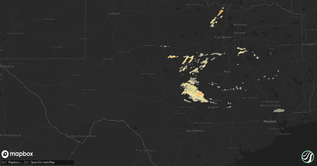
Hail Map in Texas on May 5, 2023
Get this storm
May 5 map
$229
one time, instant access
Download today. No call, no setup
Keep the $229
Bought the map and want the full workflow? Apply the entire $229 to a subscription within 7 days. None of it is wasted.
Every map, not just this one
This buys you this map. Subscription and you get every map we run, in the markets you choose from a few cities to whole states to nationwide. Plus real-time alerts the moment a storm fires.
Contact data
Name, contact info, occupancy, even credit band for addresses in the footprint. You go from where it hit to who to call.
Become the source they trust
Unlimited branding weather history reports on demand. You already have the documented answer ready for the property owner, and you are the one who showed up with it.
Property data and RoofTrace estimates
Pull up any address you have got, its value and the exact code rules for that jurisdiction, straight from One Click Code. Then RoofTrace estimates the squares, pitch, and roof value, priced the way you price.
Storm reports in Texas
Texas
| Date | Description |
|---|---|
| 05/05/20236:58 PM CDT | Egg size hail reported on hwy 29 near the brandenburg plumbing business to the east of burnet. |
| 05/05/20236:56 PM CDT | Report from mping ping pong ball |
| 05/05/20236:56 PM CDT | A local report indicates 2.00 inch wind near 3 ESE BURNET |
| 05/05/20236:50 PM CDT | Report from mping quarter |
| 05/05/20236:44 PM CDT | A local report indicates 1.75 inch wind near BURNET |
| 05/05/20236:35 PM CDT | Cracked windshield on vehicle. |
| 05/05/20236:32 PM CDT | Video of ping pong size hail near the intersection of hwy 29 and rr 2341. Time estimated via radar. |
| 05/05/20236:19 PM CDT | A local report indicates 1.00 inch wind near 5 NNE INKS LAKE STATE P |
| 05/05/20235:34 PM CDT | Report from mping. |
| 05/05/20235:32 PM CDT | Report from mping: golf ball |
| 05/05/20235:26 PM CDT | Report from mping: ping pong ball |
| 05/05/20235:17 PM CDT | Report from mping: golf ball |
| 05/05/20235:03 PM CDT | A local report indicates 1.25 inch wind near 4 SSW HARKEYVILLE |
| 05/05/20235:02 PM CDT | Pea to quarter sized hail falling at the state park. |
| 05/05/20234:40 PM CDT | A local report indicates 1.25 inch wind near 9 WNW VALLEY VIEW |
| 05/05/20234:40 PM CDT | A local report indicates 1.25 inch wind near ALVORD |
| 05/05/20234:32 PM CDT | 4 inch tree limbs down along fm 1655. |
| 05/05/20234:30 PM CDT | 4 inch tree limbs down along fm 1450. |
| 05/05/20234:26 PM CDT | A local report indicates 1.00 inch wind near 4 SSE EARLY |
| 05/05/20234:15 PM CDT | A local report indicates 2.00 inch wind near 9 ESE OPLIN |
| 05/05/20234:15 PM CDT | A local report indicates 1.00 inch wind near 1 N BRIDGEPORT |
| 05/04/202311:53 PM CDT | Delayed report: kact asos reported 50 knot wind gust. |
| 05/04/202311:32 PM CDT | Nearly 1800 customers reported without power due to thunderstorms in robertson and brazos counties. |
| 05/04/202311:30 PM CDT | Weatherstem station at kyle field. |
| 05/04/202311:20 PM CDT | Social media picture of metal roofing blown off of a barn near the intersection of thurman rd and old cameron ranch road north of bryan. Time estimated by radar. |
| 05/04/202310:47 PM CDT | Estimated winds of 50 to 60 mph at fm 1460 and westinghouse rd. |
| 05/04/202310:25 PM CDT | A local report indicates 1.00 inch wind near 3 E ENCHANTED ROCK STAT |
| 05/04/202310:18 PM CDT | Report from mping quarter. |
| 05/04/202310:16 PM CDT | T35 |
| 05/04/202310:10 PM CDT | A local report indicates 1.00 inch wind near 1 NNW LAGO VISTA |
| 05/04/202310:02 PM CDT | 64 mph measured at aprswxnet/cwop station fw7040 in lago vista. |
| 05/04/20239:25 PM CDT | Mostly dime and nickel size with quarter size mixed in. |
| 05/04/20239:11 PM CDT | Report from mping half dollar. |
| 05/04/20239:02 PM CDT | A local report indicates 1.00 inch wind near 2 W BERTRAM |
| 05/04/20238:59 PM CDT | Report from mping quarter. |
| 05/04/20238:56 PM CDT | Report from mping quarter. |
| 05/04/20238:56 PM CDT | Report from mping 3-inch tree limbs broken... Power poles broken. |
| 05/04/20238:56 PM CDT | Downed trees near the intersection of fm 1431 and phillips ranch rd; 1100 people without power in granite shoals. Time estimated via radar. |
| 05/04/20238:55 PM CDT | Reports of down power pole and several transformers out near sunrise beach. Time estimated via radar. |
| 05/04/20238:50 PM CDT | Trees and power poles down from sandy mountain to sunrise beach. Time estimated via radar. |
| 05/04/20238:45 PM CDT | Report from mping quarter. |
| 05/04/20238:42 PM CDT | Reports of down power pole and several transformers out near kingsland. Time estimated via radar. |
| 05/04/20238:25 PM CDT | A local report indicates 1.25 inch wind near 1 E LLANO |
| 05/04/20238:15 PM CDT | A local report indicates 68 MPH wind near 3 NNE LLANO |
| 05/04/20238:07 PM CDT | A local report indicates 1.00 inch wind near LLANO |
| 05/04/20237:30 PM CDT | Time estimated via radar. |
| 05/04/20237:10 PM CDT | Intersection of fm 690 and peninsula drive. Time estimated. |
| 05/04/20237:10 PM CDT | A local report indicates 1.00 inch wind near 3 N HICO |
| 05/04/20237:05 PM CDT | Social media picture of hail measured up to near tennis ball size near the burnet municipal airport with rough time estimate of 7:05 pm. |
All States Impacted by Hail Map on May 5, 2023
Cities Impacted by Hail Map on May 5, 2023
- Lake City, MN
- Pinola, MS
- Newhebron, MS
- Mendenhall, MS
- Prentiss, MS
- Mount Olive, MS
- Bassfield, MS
- Carson, MS
- Collins, MS
- Sumrall, MS
- Seminary, MS
- Hattiesburg, MS
- Coleman, TX
- Clyde, TX
- Abilene, TX
- Burkett, TX
- Cross Plains, TX
- Baird, TX
- Brookesmith, TX
- Brownwood, TX
- Bridgeport, TX
- Paradise, TX
- Chico, TX
- Alvord, TX
- Early, TX
- Zephyr, TX
- Blanket, TX
- San Saba, TX
- Cherokee, TX
- Hay Springs, NE
- Forestburg, TX
- May, TX
- Comanche, TX
- Decatur, TX
- Era, TX
- Gainesville, TX
- Rosston, TX
- Muenster, TX
- Sidney, TX
- Alma, NE
- Republican City, NE
- Naponee, NE
- De Leon, TX
- Mullin, TX
- Goldthwaite, TX
- Bloomington, NE
- Franklin, NE
- Tow, TX
- Lampasas, TX
- Riverton, NE
- Harrison, NE
- Georgetown, MS
- Bush, LA
- Poplarville, MS
- Picayune, MS
- Carriere, MS
- Petal, MS
- New Augusta, MS
- Lusk, WY
- Morrill, NE
- Lyman, NE
- Minatare, NE
- Bayard, NE
- Hazlehurst, MS
- Silver Creek, MS
- Crystal Springs, MS
- Harrisville, MS
- Magee, MS
- Stamford, NE
- Oxford, NE
- Orleans, NE
- Burnet, TX
- Bluffton, TX
- Hamilton, TX
- Inavale, NE
- Bertram, TX
- Art, TX
- Mason, TX
- Castell, TX
- Valley Spring, TX
- Red Cloud, NE
- Eustis, NE
- Cambridge, NE
- Holbrook, NE
- Julesburg, CO
- Amherst, CO
- Venango, NE
- Wray, CO
- Haigler, NE
- Parks, NE
- Benkelman, NE
- Imperial, NE
- Champion, NE
- Llano, TX
- Arapahoe, NE
- Elwood, NE
- Grant, NE
- Enders, NE
- Edison, NE
- Bertrand, NE
- Wauneta, NE
- Marble Falls, TX
- Wilcox, NE
- Hayes Center, NE
- Cozad, NE
- Hildreth, NE
- Loomis, NE
- Buchanan Dam, TX
- Holdrege, NE
- Kingsland, TX
- Lexington, NE
- Maywood, NE
- Paoli, CO
- Holyoke, CO
- Haxtun, CO
- Sutherland, NE
- Paxton, NE
- Elsie, NE
- North Platte, NE
- Wallace, NE
- Hershey, NE
- Palisade, NE
- Funk, NE
- Axtell, NE
- Palmer, TX
- Ennis, TX
- Corsicana, TX
- Rice, TX
- Chatfield, TX
- Maxwell, NE
- Minden, NE
- Kearney, NE
- Fredericksburg, TX
- Round Mountain, TX
- Spicewood, TX
- Leander, TX
- Waxahachie, TX
- Wellfleet, NE
- Crookston, NE
- Farnam, NE
- Hico, TX
- Stephenville, TX
- Dickens, NE
- Angora, NE
- Rushville, NE
- Oshkosh, NE
- Ogallala, NE
- Madrid, NE
- Ovid, CO
- Lisco, NE
- Edgemont, SD
- Moorefield, NE
- Meridian, TX
- Morgan, TX
- Walnut Springs, TX
- Iredell, TX
- Rising Star, TX
- Carlton, TX
- Evant, TX
- Pottsville, TX
- Stockville, NE
- Priddy, TX
- Blum, TX
- Kopperl, TX
- Dublin, TX
- Lebanon, KS
- Lometa, TX
- Broadwater, NE
- Bridgeport, NE
- Rio Vista, TX
- Cleburne, TX
- Glen Rose, TX
- Gustine, TX
- Perkinston, MS
- Sunset, TX
- Brady, NE
- Killeen, TX
- Pearl River, LA
- Horseshoe Bay, TX
- Pontotoc, TX
- Bangs, TX
- Abita Springs, LA
- Covington, TX
- Fort Hood, TX
- Hubbard, TX
- Coolidge, TX
- Salado, TX
- Belton, TX
- Bartley, NE
- Rochelle, TX
- Overton, NE
- Curtis, NE
- Smithfield, NE
- Elm Creek, NE
- Eddyville, NE
- Sumner, NE
- Loup City, NE
- Calvert, TX
- Platte Center, NE
- Primrose, NE
- Mason City, NE
- Blooming Grove, TX
- Barry, TX
- Litchfield, NE
- Bend, TX
- Pleasanton, NE
- Paige, TX
- Amherst, NE
- Cairo, NE
- Newman Grove, NE
- Monroe, NE
- Gibbon, NE
- Palmer, NE
- Belgrade, NE
- Fullerton, NE
- Malakoff, TX
- Saint Paul, NE
- Saint Libory, NE
- Farwell, NE
- Boelus, NE
- Dannebrog, NE
- Ashton, NE
- Elba, NE
- Rockville, NE
- Archer, NE
- Chapman, NE
- Wolbach, NE
- Cedar Rapids, NE
- Pilger, NE
- Wisner, NE
- Bullard, TX
- Flint, TX
- West Point, NE
- Dodge, NE
- Willow City, TX
- Cedar Park, TX
- Austin, TX
- Pflugerville, TX
- Manor, TX
- Saint Edward, NE
- McCook, NE
- Howells, NE
- Clarkson, NE
- Kennard, TX
- Gothenburg, NE
- Hearne, TX
- Franklin, TX
- Genoa, NE
- Lindsay, NE
- Tennessee Colony, TX
- Montalba, TX
- Athens, TX
- Goldsboro, TX
- Creston, NE
- Columbus, NE
- Leigh, NE
- Kemp, TX
- Silver Creek, NE
- Crockett, TX
- Central City, NE
- Rogers, TX
- Lexington, TX
- Odessa, NE
- Shelton, NE
- Cameron, TX
- Alto, TX
- Miller, NE
- Centerville, TX
- Bryan, TX
- Buckholts, TX
- Grand Island, NE
- Holland, TX
- Lincoln, TX
- Giddings, TX
- Mabank, TX
- Bancroft, NE
- Pender, NE
- Oconto, NE
- Essex, IA
- Red Oak, IA
- Sidney, IA
- Tabor, IA
- Winnebago, NE
- Liberty, TX
- Dayton, TX
- New Caney, TX
- Huffman, TX
- Cleveland, TX
- Porter, TX
- Humphrey, NE
- Callaway, NE
- Imogene, IA
- Randolph, IA
- Beemer, NE
- Emerson, IA
- Shenandoah, IA
- Farragut, IA


